North Carolina Highway 182

Last updated

NC 182.svg

North Carolina Highway 182
NC 182 map.svg
Route information
Maintained by NCDOT
Length 23.3 mi [1] (37.5 km)
Existed 1952 – present
Major junctions
West endNC 226.svg NC 226 in Polkville
East endNC 27.svg NC 27 near Lincolnton
Location
Counties Cleveland, Lincoln
Highway system
NC 181.svg NC 181 NC 183 NC 183.svg

North Carolina Highway 182 (NC 182) is a primary state highway in the U.S. state of North Carolina. It serves to connect the towns of Polkville and Lawndale with the city of Lincolnton.

A state highway, state road, or state route is usually a road that is either numbered or maintained by a sub-national state or province. A road numbered by a state or province falls below numbered national highways in the hierarchy. Roads maintained by a state or province include both nationally numbered highways and un-numbered state highways. Depending on the state, "state highway" may be used for one meaning and "state road" or "state route" for the other.

North Carolina State of the United States of America

North Carolina is a state in the southeastern region of the United States. It borders South Carolina and Georgia to the south, Tennessee to the west, Virginia to the north, and the Atlantic Ocean to the east. North Carolina is the 28th-most extensive and the 9th-most populous of the U.S. states. The state is divided into 100 counties. The capital is Raleigh, which along with Durham and Chapel Hill is home to the largest research park in the United States. The most populous municipality is Charlotte, which is the second-largest banking center in the United States after New York City.

Polkville, North Carolina Town in North Carolina, United States

Polkville is a small city in Cleveland County, North Carolina, United States. The population was 545 at the 2010 census.

Contents

Route description

NC 27 and NC 182, near Lincolnton NC27-NC182-Lincolnton.jpg
NC 27 and NC 182, near Lincolnton

NC 182 is a two-lane rural highway that begins at NC 226 in Polkville and ends at NC 27 near Lincolnton. The 23.3-mile (37.5 km) route is a mildly curvy road crossing the First Broad River in Lawndale. [1] All of NC 182 is concurrent with North Carolina Bicycle Route 8. [2]

North Carolina Highway 226 highway in North Carolina

North Carolina Highway 226 (NC 226) is a primary state highway in the U.S. state of North Carolina. Traveling north–south through Western North Carolina, it connects the cities and towns of Grover, Shelby, Marion, Spruce Pine and Bakersville. It also a scenic byway in the South Mountains area and connects with the summer colony of Little Switzerland, via NC 226A.

North Carolina Highway 27 highway in North Carolina

North Carolina Highway 27 (NC 27) is a primary state highway in the U.S. state of North Carolina. The route traverses 198 miles (319 km) through southern and central North Carolina, about 100 miles (160 km) of it as a concurrency with NC 24.

The First Broad River is a tributary of the Broad River, about 60 mi (95 km) long in western North Carolina in the United States. Via the Broad and Congaree Rivers, it is part of the watershed of the Santee River, which flows to the Atlantic Ocean.

History

NC 182 was established in 1952 as a renumbering of NC 180 between Polkville and Fallston and a new primary routing between Fallston and NC 7 near Lincolnton. [3] The route has remained unchanged since inception.

North Carolina Highway 180 highway in North Carolina

North Carolina Highway 180 (NC 180) is a primary state highway in the U.S. state of North Carolina. The highway serves as a bypass east of Shelby.

Fallston, North Carolina Hamlet in North Carolina, United States

Fallston is a hamlet in Cleveland County, North Carolina, United States. The population was 607 at the 2010 census.

Junction list

CountyLocationmi [1] kmDestinationsNotes
Cleveland Polkville 0.00.0NC 226.svg NC 226 (Polkville Road) Shelby, Marion
Fallston 8.513.7NC 18.svg NC 18 (Fallston Road) Shelby, Morganton
Lincoln 13.922.4NC 274.svg NC 274  Cherryville, Morganton
23.337.5NC 27.svg NC 27  Lincolnton, Morganton
1.000 mi = 1.609 km; 1.000 km = 0.621 mi

Related Research Articles

U.S. Route 321 highway in the United States

U.S. Route 321 (US 321) is a spur of U.S. Route 21. It runs for 516.9 miles (831.9 km) from Hardeeville, South Carolina to Lenoir City, Tennessee; with both serving as southern termini. It reaches its northernmost point at Elizabethton, Tennessee. Because of its unusual "north–south–north" routing, U.S. Route 321 intersects both Interstate 40 and U.S. Route 70 three separate times. The highway serves different roles in each state: An alternate route to interstates in South Carolina, a major highway in North Carolina, and a scenic route in Tennessee.

North Carolina Highway 615 highway in North Carolina

North Carolina Highway 615 (NC 615) is a primary state highway in the U.S. state of North Carolina. It connects Knotts Island with mainland North Carolina via the Currituck–Knotts Island Ferry.

North Carolina Highway 82 highway in North Carolina

North Carolina Highway 82 (NC 82) is a primary state highway in the U.S. state of North Carolina. The highway traverses where the Battle of Averasborough took place and connects the towns of Erwin, Godwin and Falcon. Though the road is signed as east and west, it runs physically north from Erwin to US 13 to the south near Cooper.

North Carolina Highway 150 highway in North Carolina

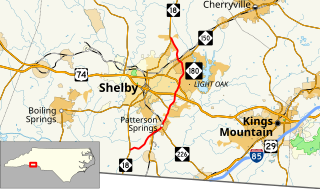
North Carolina Highway 150 (NC 150) is a primary state highway in the U.S. state of North Carolina. It serves the Foothills and Piedmont Triad areas of the state, connecting the cities of Shelby, Mooresville, Salisbury and Winston-Salem.

North Carolina Highway 10 highway in North Carolina

North Carolina Highway 10 (NC 10) is a primary state highway in the U.S. state of North Carolina. Originally established as the state's central highway, from Murphy to Beaufort. Nowadays, it serves to connect the city of Newton with the nearby communities and towns in the foothills region.

North Carolina Highway 87 highway in North Carolina

North Carolina Highway 87 (NC 87) is a primary state highway in the U.S. state of North Carolina. NC 87 begins in the Atlantic coastal town of Southport and crosses into Virginia at the Virginia state line five miles (8 km) north of Eden in Rockingham County. At 240 miles (390 km) in length, NC 87 is the second longest state highway in the U.S. state of North Carolina. Labeled as a north–south route, NC 87 travels along a relatively straight southeast–northwest path, connecting Cape Fear region with the Piedmont and connecting the cities of Fayetteville, Sanford, and Burlington.

North Carolina Highway 101 highway in North Carolina

North Carolina Highway 101 (NC 101) is a primary state highway in the U.S. state of North Carolina that serves as a shortcut for U.S. Route 70 (US 70). It links Havelock to Beaufort, bypassing Morehead City. Most of the area along NC 101 is rural with many farms and swamps.

North Carolina Highway 46 highway in North Carolina

North Carolina Highway 46 (NC 46) is a primary state highway in the U.S. state of North Carolina; it is entirely in Northampton County. The route primarily connects the communities on the north side of Roanoke Rapids Lake and Lake Gaston, as well as the north side of the Roanoke River in the county.

North Carolina Highway 119 highway in North Carolina

North Carolina Highway 119 (NC 119) is a primary state highway in the U.S. state of North Carolina.

North Carolina Highway 62 highway in North Carolina

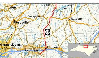
North Carolina Highway 62 (NC 62) is a primary state highway in the U.S. state of North Carolina. Primarily in the Piedmont Triad, it runs from NC 109 in Thomasville northeast to the Virginia state line in Milton.

North Carolina Highway 903 highway in North Carolina

North Carolina Highway 903 (NC 903) is a primary state highway in the U.S. state of North Carolina. It serves as predominantly rural highway in the Inner Banks region and arterial road in and around Greenville. The road covers a total of 200 miles (320 km), in a zigzag pattern through the state.

North Carolina Highway 242 highway in North Carolina

North Carolina Highway 242 (NC 242) is a primary state highway in the U.S. state of North Carolina. It traverses from Cerro Gordo to Benson, connecting the cities of Bladenboro, Elizabethtown, and Roseboro.

North Carolina Highway 306 highway in North Carolina

North Carolina Highway 306 (NC 306) is a primary state highway in the U.S. state of North Carolina. The highway provides a link between Havelock, Minnesott Beach, and Grantsboro. The route is primarily rural, and uses two free ferries to cross the Neuse and Pamlico Rivers before reaching NC 92/NC 99 near Gaylord.

North Carolina Highway 181 highway in North Carolina

North Carolina Highway 181 (NC 181) is a primary state highway in the U.S. state of North Carolina. It runs north–south from Morganton to Newland.

North Carolina Highway 93 highway in North Carolina

North Carolina Highway 93 (NC 93) is a primary state highway in the U.S. state of North Carolina. It runs from the Virginia state line to the community of Twin Oaks, entirely in Alleghany County.

North Carolina Highway 217 highway in North Carolina

North Carolina Highway 217 (NC 217) is a primary state highway in the U.S. state of North Carolina. The highway connects the town of Linden to nearby Erwin to Fayetteville.

North Carolina Highway 308 highway in North Carolina

North Carolina Highway 308 (NC 308) is a primary state highway in the U.S. state of North Carolina. It serves mainly to connect the city of Windsor to communities and towns in eastern Bertie County.

References

  1. 1 2 3 Google (June 11, 2014). "North Carolina Highway 182" (Map). Google Maps . Google. Retrieved June 11, 2014.
  2. "NC 8 - Southern Highlands". North Carolina Bike Routes Beta. Walk Bike North Carolina Bicycle Routes. Retrieved April 14, 2016.
  3. North Carolina Official Highway Map (PDF) (Map). Cartography by NCDOT. North Carolina Department of Transportation. 1960. Retrieved June 11, 2014.
KML file (edithelp)
KML is from Wikidata