South Gastonia, North Carolina

Last updated

South Gastonia, North Carolina
NCMap-doton-SouthGastonia.PNG
Location of South Gastonia, North Carolina
Coordinates: 35°13′3″N81°12′17″W / 35.21750°N 81.20472°W / 35.21750; -81.20472
Country Flag of the United States.svg  United States
State Flag of North Carolina.svg  North Carolina
County Gaston
Area
  Total6.4 sq mi (16.7 km2)
  Land6.4 sq mi (16.7 km2)
  Water0.0 sq mi (0.0 km2)
Elevation
768 ft (234 m)
Population
 (2000)
  Total5,433
  Density844.5/sq mi (326.1/km2)
Time zone UTC-5 (Eastern (EST))
  Summer (DST) UTC-4 (EDT)
ZIP code
28052
Area code 704
FIPS code 37-63180 [1]
GNIS feature ID1022708 [2]

South Gastonia is a neighborhood of Gastonia in Gaston County, North Carolina, United States. The population was 5,433 at the 2000 census, at which time it was erroneously listed as a census-designated place. [3] The majority of the community has now been annexed into the city of Gastonia and is now considered to be a neighborhood on the southside of Gastonia.

Contents

Geography

South Gastonia is located at 35°13′03″N81°12′17″W / 35.217433°N 81.204828°W / 35.217433; -81.204828 . [4]

According to the United States Census Bureau, the CDP has a total area of 6.4 square miles (17 km2), all land.

Demographics

As of the census [1] of 2000, there were 5,433 people, 2,061 households, and 1,543 families residing in the CDP. The population density was 844.5 inhabitants per square mile (326.1/km2). There were 2,232 housing units at an average density of 347.0 per square mile (134.0/km2). The racial makeup of the CDP was 84.87% White, 12.04% African American, 0.31% Native American, 0.63% Asian, 1.23% from other races, and 0.92% from two or more races. Hispanic or Latino of any race were 1.88% of the population.

There were 2,061 households, out of which 32.7% had children under the age of 18 living with them, 55.4% were married couples living together, 13.7% had a female householder with no husband present, and 25.1% were non-families. 19.7% of all households were made up of individuals, and 7.0% had someone living alone who was 65 years of age or older. The average household size was 2.64 and the average family size was 3.00.

In the CDP the population was spread out, with 24.9% under the age of 18, 8.6% from 18 to 24, 31.1% from 25 to 44, 24.7% from 45 to 64, and 10.8% who were 65 years of age or older. The median age was 36 years. For every 100 females, there were 97.0 males. For every 100 females age 18 and over, there were 95.1 males.

The median income for a household in the CDP was $38,898, and the median income for a family was $40,595. Males had a median income of $31,321 versus $22,285 for females. The per capita income for the CDP was $16,707. About 7.4% of families and 10.7% of the population were below the poverty line, including 18.5% of those under age 18 and 2.3% of those age 65 or over.

Related Research Articles

<span class="mw-page-title-main">Plantation Island, Florida</span> Census-designated place in Florida

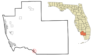
Plantation Island is a census-designated place (CDP) in Collier County, Florida, United States. The population was 163 at the 2010 census. It is part of the Naples–Marco Island Metropolitan Statistical Area.

<span class="mw-page-title-main">Cypress Gardens, Florida</span> Census-designated place in Florida, United States

Cypress Gardens is a census-designated place (CDP) in Polk County, Florida, United States. The population was 10,169 at the 2020 census. It is part of the Lakeland–Winter Haven Metropolitan Statistical Area.

<span class="mw-page-title-main">Gulf Gate Estates, Florida</span> Census-designated place in Florida, United States

Gulf Gate Estates is a census-designated place (CDP) in Sarasota County, Florida, United States. The population was 10,911 at the 2010 census. It is part of the North Port–Sarasota–Bradenton Metropolitan Statistical Area.

<span class="mw-page-title-main">Samsula-Spruce Creek, Florida</span> CDP in Florida, United States

Samsula-Spruce Creek is a census-designated place (CDP) in Volusia County, Florida, United States. The population was 5,047 at the 2010 census. While many households reside here, it is principally an agricultural area west of the cities of Port Orange and New Smyrna Beach.

<span class="mw-page-title-main">Lake Summerset, Illinois</span> Census Designated Place in Illinois, United States

Lake Summerset is a census-designated place (CDP) in Stephenson and Winnebago counties in Illinois. The population was 2,048 at the 2010 census.

<span class="mw-page-title-main">Canada Creek Ranch, Michigan</span> Census-designated place & unincorporated community in Michigan, United States

Canada Creek Ranch is an unincorporated community in Montmorency Township, Montmorency County in the U.S. state of Michigan. It is a census-designated place (CDP) used for statistical purposes. The population was 405 at the 2000 census.

<span class="mw-page-title-main">Oakville, Missouri</span> CDP in Missouri, United States

Oakville is a census-designated place (CDP) in south St. Louis County, Missouri, United States. The population was 36,301 at the 2020 census. Oakville is 18 miles south of the city of St. Louis and borders the Mississippi and Meramec rivers; the area is part of "South County".

Elrod is a census-designated place (CDP) in Robeson County, North Carolina, United States. The population was 441 at the 2000 census.

Raemon is a census-designated place (CDP) in Robeson County, North Carolina, United States. The population was 212 at the 2000 census.

<span class="mw-page-title-main">Holiday Valley, Ohio</span> Census-designated place in Ohio, United States

Holiday Valley is a census-designated place (CDP) in Clark County, Ohio, United States. The population was 1,480 at the 2020 census. It is part of the Springfield, Ohio Metropolitan Statistical Area.

<span class="mw-page-title-main">Hartstown, Pennsylvania</span> Census-designated place in Pennsylvania, United States

Hartstown is a census-designated place (CDP) in Crawford County, Pennsylvania, United States. The population was 201 at the 2010 census, down from 246 in 2000.

<span class="mw-page-title-main">Morrisville, Greene County, Pennsylvania</span> Census-designated place in Pennsylvania, United States

Morrisville is a census-designated place (CDP) in Franklin Township, Greene County, Pennsylvania, United States. The population was 1,265 at the 2010 census.

<span class="mw-page-title-main">Harrison City, Pennsylvania</span> Census-designated place in Pennsylvania, United States

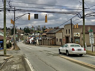
Harrison City is a census-designated place (CDP) in Westmoreland County, Pennsylvania, United States. The population was 174 at the 2020 census.

<span class="mw-page-title-main">North Eagle Butte, South Dakota</span> Census-designated place in South Dakota, United States

North Eagle Butte is a census-designated place (CDP) in Dewey County, South Dakota, United States, along the 45th parallel. The population was 1,879 at the 2020 census.

Oak Grove is a census-designated place (CDP) in Washington County, Tennessee, United States. The population was 4,425 at the 2010 census. It is part of the Johnson City Metropolitan Statistical Area, which is a component of the Johnson City–Kingsport–Bristol, TN-VA Combined Statistical Area – commonly known as the "Tri-Cities" region.

<span class="mw-page-title-main">Ratamosa, Texas</span> Census-designated place in Texas, United States

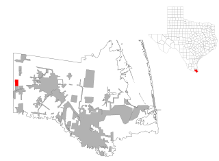
Ratamosa is a census-designated place (CDP) in Cameron County, Texas, United States. The population was 254 at the 2010 census. It is part of the Brownsville–Harlingen Metropolitan Statistical Area.

<span class="mw-page-title-main">Northwest Snohomish, Washington</span> Former CDP in Washington, United States

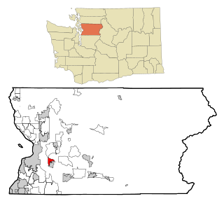
Northwest Snohomish is a former census-designated place (CDP) in Snohomish County, Washington, United States. The population was 2,061 at the 2000 census. The CDP ceased to exist at the 2010 census, with some parts having been annexed by Snohomish and other parts going to the new Fobes Hill CDP.

<span class="mw-page-title-main">Coal Fork, West Virginia</span> Census-designated place in West Virginia, United States

Coal Fork is an unincorporated census-designated place (CDP) in Kanawha County, West Virginia, United States. It is part of a larger unincorporated community known as Campbells Creek, approximately 10 minutes east of Charleston. The population was 1,233 at the 2010 census.

<span class="mw-page-title-main">Beaver, West Virginia</span> Census-designated place in West Virginia, United States

Beaver is a census-designated place (C.D.P.) in Raleigh County, West Virginia, United States. The population was 1,308 at the 2010 census.

<span class="mw-page-title-main">Piney View, West Virginia</span> Census-designated place in West Virginia, United States

Piney View is a census-designated place (CDP) in Raleigh County, West Virginia, United States. The population was 989 at the 2010 census.

References

  1. 1 2 "U.S. Census website". United States Census Bureau . Retrieved January 31, 2008.
  2. "US Board on Geographic Names". United States Geological Survey. October 25, 2007. Retrieved January 31, 2008.
  3. U.S. Census Bureau Geographic Change Notes
  4. "US Gazetteer files: 2010, 2000, and 1990". United States Census Bureau. February 12, 2011. Retrieved April 23, 2011.