McAdenville, North Carolina | |
|---|---|
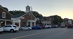 Main Street | |
| Nickname: Christmas Town USA | |
 Location of McAdenville, North Carolina | |
| Coordinates: 35°15′55″N81°04′49″W / 35.26528°N 81.08028°W | |
| Country | |
| State | |
| County | Gaston |
| Government | |
| • Mayor | Jim Robinette[ citation needed ] |
| • Mayor Pro Tempore | C. Reid Washam[ citation needed ] |
| • Council Members | Carrie Bailey, Greg Richardson, Joe Rankin, Jay McCosh[ citation needed ] |
| Area | |
• Total | 1.42 sq mi (3.67 km2) |
| • Land | 1.36 sq mi (3.51 km2) |
| • Water | 0.06 sq mi (0.16 km2) |
| Elevation | 633 ft (193 m) |
| Population (2020) | |
• Total | 890 |
| • Density | 656.34/sq mi (253.46/km2) |
| Time zone | UTC-5 (Eastern (EST)) |
| • Summer (DST) | UTC-4 (EDT) |
| ZIP code | 28101 |
| Area code | 704 |
| FIPS code | 37-39880 [3] |
| GNIS feature ID | 2406120 [2] |
| Website | www |

McAdenville is a small town in Gaston County, North Carolina, United States. It is a suburb of Gastonia and located east of Gastonia. The population was 890 at the 2020 census. [4]


