Mount Holly, North Carolina

Last updated

Mount Holly, North Carolina
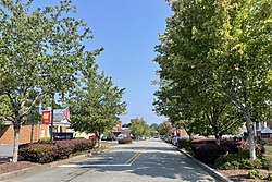
Mount Holly NC Downtown.jpg
Downtown Mount Holly
Mount Holly, NC City Seal.jpg
NCMap-doton-MountHolly.PNG
Location of Mount Holly, North Carolina
Coordinates: 35°18′51″N81°00′28″W / 35.31417°N 81.00778°W / 35.31417; -81.00778
Country Flag of the United States (23px).png  United States
State Flag of North Carolina.svg  North Carolina
County Gaston
IncorporatedMarch 11, 1879
Government
   Mayor David Moore
Area
[1]
  Total11.30 sq mi (29.26 km2)
  Land11.21 sq mi (29.05 km2)
  Water0.08 sq mi (0.21 km2)
Elevation
[2]
627 ft (191 m)
Population
 (2020)
  Total17,703
  Density1,578.51/sq mi (609.46/km2)
Time zone UTC-5 (Eastern (EST))
  Summer (DST) UTC-4 (Eastern (EDT))
ZIP code
28120, 28012
Area code(s) 704, 980
FIPS code 37-44960 [3]
GNIS feature ID2404319 [2]
Website www.mtholly.us

Mount Holly is a small suburban city in northeastern Gaston County, North Carolina, United States. The city is situated just west of the Catawba River, north of Interstate 85, south of North Carolina State Highway 16. The population was 17,703 at the 2020 census, [4] up from 13,656 in 2010.

Contents

Geography

According to the United States Census Bureau, the city has a total area of 10.0 square miles (25.9 km2), of which 9.8 square miles (25.4 km2) is land and 0.19 square miles (0.5 km2), or 1.98%, is water. [5]

Mount Holly is located 12 miles (19 km) northeast of Gastonia.

History

Mount Holly Cotton Mill Mt. Holly Cotton Mill, Mt. Holly, NC (8170289596).jpg
Mount Holly Cotton Mill

Land grants were first issued in the Mount Holly area by King George II of Great Britain around 1750. In 1754, a land grant was issued to James Kuykendall of Holland in the locale known as Dutchman's Creek. Later in 1838, a post office in the area was named Woodlawn. In 1875, the name of the town was changed to Mount Holly, after the Mount Holly Cotton Mill that was started that year. The name "Mount Holly" was used in recognition of the famed yarn made at a spinning mill in Mount Holly, New Jersey.

A.P. and D.E. Rhyne and Ambrose Costner originally owned the Mount Holly Cotton Mill. It was the fourth mill to be built in Gaston County and is the oldest surviving mill today. The mill's success and the prosperity of the area as a whole led local residents to petition the North Carolina General Assembly for incorporation of Mount Holly in 1879.

The first railroad in Gaston County, the Carolina Central Railway, began serving Mount Holly in 1860. The line, which runs parallel with North Carolina State Highway 27, is still in service and operated by CSX. In 1911, construction began on the area's second railroad, the Piedmont and Northern Railway. On May 20, 1912, it made its first run from Charlotte to Gastonia.

Electricity became available to homes and businesses around the turn of the twentieth century. The Woodlawn Mill, located on Woodlawn Avenue, was built in 1906 and was the first mill in Gaston County to be served with electricity. [6]

The Downtown Mount Holly Historic District and Mount Holly Cotton Mill are listed on the National Register of Historic Places. [7] [8]

Demographics

Historical population
CensusPop.Note
1890 472
1900 63033.5%
1910 526−16.5%
1920 1,160120.5%
1930 2,25494.3%
1940 2,055−8.8%
1950 2,2419.1%
1960 4,03780.1%
1970 5,10726.5%
1980 4,530−11.3%
1990 7,71070.2%
2000 9,61824.7%
2010 13,65642.0%
2020 17,70329.6%
U.S. Decennial Census [9]

2020 census

Mount Holly racial composition [10]
RaceNumberPercentage
White (non-Hispanic)11,73466.28%
Black or African American (non-Hispanic)3,18918.01%
Native American 500.28%
Asian 4952.79%
Pacific Islander 80.05%
Other/Mixed 8794.97%
Hispanic or Latino 1,3497.62%

As of the 2020 United States census, there were 17,703 people, 6,134 households, and 3,846 families residing in the city.

2000 census

As of the census [3] of 2000, there were 9,618 people, 4,028 households, and 2,658 families residing in the city. The population density was 1,236.3 inhabitants per square mile (477.3/km2). There were 4,241 housing units at an average density of 545.2 per square mile (210.5/km2). The racial composition of the city in 2010 was: 76.3% White, 15.8% Black or African American, 2.60% Asian American, 7.3% Hispanic or Latino American, 0.1% Native American, 0.0% Native Hawaiian or Other Pacific Islander, 0.75% some other race, and 0.9% two or more races.

There were 4,028 households, out of which 29.5% had children under the age of 18 living with them, 47.1% were married couples living together, 14.0% had a female householder with no husband present, and 34.0% were non-families. 27.9% of all households were made up of individuals, and 10.2% had someone living alone who was 65 years of age or older. The average household size was 2.37 and the average family size was 2.89.

In the city, the population was spread out, with 23.4% under the age of 18, 8.4% from 18 to 24, 34.3% from 25 to 44, 20.6% from 45 to 64, and 13.3% who were 65 years of age or older. The median age was 35 years. For every 100 females, there were 92.6 males. For every 100 females age 18 and over, there were 88.4 males.

The median income for a household in the city was $39,459, and the median income for a family was $46,295. Males had a median income of $32,128 versus $23,965 for females. The per capita income for the city was $20,161. About 8.2% of families and 10.8% of the population were below the poverty line, including 16.5% of those under age 18 and 8.5% of those age 65 or over.

Government

Mount Holly Fire Department Mount Holly, North Carolina Fire Department.jpg
Mount Holly Fire Department

The City of Mount Holly has a Council-Manager form of government with a mayor and six council members. The mayor is elected every four years in November, and the council members, elected at-large, serve four-year staggered terms. The city council appoints a professional city manager to run the day-to-day operations. [11]

Education

Mount Holly city sign Mount Holly NC City Sign.jpg
Mount Holly city sign

Three elementary schools (Pinewood, Catawba Heights and Ida Rankin), Mount Holly Middle School, East Gaston High School and Stuart W. Cramer High School are the public schools that serve Mount Holly. All six schools are part of the Gaston County Schools. Mountain Island Charter School is also located near Mount Holly near Highway 16. Because of Mount Holly's location, residents there have access to a number of public and private colleges and universities, including Belmont Abbey College, Gaston College, Central Piedmont Community College, Queens University of Charlotte, Pfeiffer University, Johnson and Wales University, the University of North Carolina at Charlotte, and Johnson C. Smith University.

The Mount Holly Branch of the Gaston County Public Library serves this community. [12]

Economy

Improvements in the regional transportation network and the economic growth of the Charlotte-Mecklenburg area, and Mount Holly's strategic location between Charlotte and Gastonia, have created conditions for an expanding population in recent years.

Freightliner manufacturing facility in Mount Holly Freightliner Factory Mount Holly NC.jpg
Freightliner manufacturing facility in Mount Holly

The textile industry continues to play a significant role in the Mount Holly area. The Gaston County Economic Development Commission's current manufacturing directory lists 19 manufacturing firms in the area, ten of which are textile related. The city's largest textile firm is American & Efird, Inc. (A&E), the world's second-largest thread maker. The firm was created with a 1952 merger of American Yarn and Processing Company (located in Mount Holly) and the Efird Manufacturing Company (located in Albemarle, North Carolina). American Yarn had its start in 1891 when Charles Egbert Hutchison founded the Nims Manufacturing Company on Dutchman's Creek. [13] With six plants and their corporate offices in Mount Holly, A&E employs more than 980 people and maintains a strong presence in the community. In 1990, the Freightliner Trucks manufacturing plant was annexed into the city. Freightliner and its subsidiary businesses have been a significant employer in Mount Holly since 1979. [6]

Since 2007 National Gypsum has operated a wallboard plant in Mount Holly. While gypsum wallboard is typically produced from gypsum rock, the Mount Holly plant uses byproduct gypsum produced by sulfur dioxide scrubbers at four of Duke Power's coal-fired power plants. [14]

Mount Holly's historic downtown district includes several restaurants, several churches, a coffee shop, salons and retail offerings in addition to offices, banks and other businesses. [15]

Related Research Articles

<span class="mw-page-title-main">Gaston County, North Carolina</span> County in North Carolina, United States

Gaston County is a county in the U.S. state of North Carolina. As of the 2020 census, the population was 227,943. The county seat is Gastonia. Dallas served as the original county seat from 1846 until 1911.

<span class="mw-page-title-main">Gypsum, Colorado</span> Town in Colorado, United States

The Town of Gypsum is the home rule municipality that is the most populous municipality in Eagle County, Colorado, United States. The town population was 8,040 at the 2020 United States Census, a +24.13% increase since the 2010 United States Census. Gypsum is a part of the Edwards, CO Micropolitan Statistical Area. Gypsum is the home of an American Gypsum drywall plant and mine.

<span class="mw-page-title-main">Belmont, North Carolina</span> City in North Carolina, United States

Belmont is a small suburban city in Gaston County, North Carolina, United States, located about 9 miles (14 km) east of Gastonia. The population was 10,076 at the 2010 census. Once known as Garibaldi Station, it was named for the New York banker August Belmont. Belmont is home to Belmont Abbey College.

<span class="mw-page-title-main">Bessemer City, North Carolina</span> City in North Carolina, United States

Bessemer City is a small suburban city in Gaston County, North Carolina, United States. The population is 5,340. The city is approximately 6 miles (10 km) northwest of Gastonia and 25 miles (40 km) west of Charlotte. It was settled in 1756 and founded in 1893.

<span class="mw-page-title-main">Cherryville, North Carolina</span> City in North Carolina, United States

Cherryville is a city in northwestern Gaston County, North Carolina, United States. The population was 5,760 at the 2010 census. The New Year's Shooters celebrate the area's German heritage by beginning each year with a customary chant and the honorary shooting of muskets. Cherryville is located approximately 38 miles (61 km) west of Charlotte and 16 miles (26 km) northwest of Gastonia.

<span class="mw-page-title-main">Cramerton, North Carolina</span> Town in North Carolina, United States

Cramerton is a small town in Gaston County, North Carolina, United States. It is a suburb of Charlotte and located east of Gastonia. The population was 4,165 at the 2010 census. A well-known feature is the Cramer Mountain gated development, featuring homes around an 18-hole golf course at Cramer Mountain Country Club.

<span class="mw-page-title-main">Dallas, North Carolina</span> Town in North Carolina, United States

Dallas is a town in Gaston County, North Carolina, United States, and a suburb of Charlotte, located north of Gastonia. The population was 4,488 at the 2010 census. It was named for George M. Dallas, Vice President of the United States under James K. Polk.

<span class="mw-page-title-main">Gastonia, North Carolina</span> City in North Carolina, United States

Gastonia is the most populous city in and the county seat of Gaston County, North Carolina, United States. It is the second-largest satellite city of the Charlotte area, behind Concord. The population was 80,411 in the 2020 census, up from 71,741 in 2010. Gastonia is the 13th-most populous city in North Carolina. It is part of the Charlotte-Concord-Gastonia, NC-SC Metropolitan Statistical Area, which is part of the Charlotte-Concord, NC-SC Combined Statistical Area.

<span class="mw-page-title-main">Lowell, North Carolina</span> City in North Carolina, United States

Lowell is a small city in Gaston County, North Carolina, United States, located east of Gastonia. The population was 3,526 at the 2010 census.

<span class="mw-page-title-main">McAdenville, North Carolina</span> Town in North Carolina, United States

McAdenville is a small town in Gaston County, North Carolina, United States. It is a suburb of Gastonia and located east of Gastonia. The population was 890 at the 2020 census.

<span class="mw-page-title-main">Ranlo, North Carolina</span> Town in North Carolina, United States

Ranlo is a small town in Gaston County, North Carolina, United States and a suburb of Charlotte, located north of Gastonia. As of the 2020 census, the town population was 4,511, up from 3,434 in 2010.

<span class="mw-page-title-main">South Gastonia, North Carolina</span> Neighborhood in Gaston, North Carolina, United States

South Gastonia is a neighborhood of Gastonia in Gaston County, North Carolina, United States. The population was 5,433 at the 2000 census, at which time it was erroneously listed as a census-designated place. The majority of the community has now been annexed into the city of Gastonia and is now considered to be a neighborhood on the southside of Gastonia.

<span class="mw-page-title-main">Spencer Mountain, North Carolina</span> Town in North Carolina, United States

Spencer Mountain is a town in Gaston County, North Carolina, United States. The population was 37 at the 2010 census.

<span class="mw-page-title-main">Lincolnton, North Carolina</span> City in North Carolina, United States

Lincolnton is a city in Lincoln County, North Carolina, United States within the Charlotte metropolitan area. The population was 10,486 at the 2010 census. Lincolnton is northwest of Charlotte, on the South Fork of the Catawba River. The city is the county seat of Lincoln County.

<span class="mw-page-title-main">Asheboro, North Carolina</span> City in North Carolina, United States

Asheboro is a city in and the county seat of Randolph County, North Carolina, United States. The population was 27,156 at the 2020 census. It is part of the Greensboro-High Point Metropolitan Area of the Piedmont Triad and is home of the state-owned North Carolina Zoo.

<span class="mw-page-title-main">Albemarle, North Carolina</span> City in North Carolina, United States

Albemarle is a city in and the county seat of Stanly County, North Carolina, United States. The population was 16,432 in the 2020 census.

<span class="mw-page-title-main">Clover, South Carolina</span> Town in South Carolina, United States

Clover is a town in York County, South Carolina, United States. It is located in the greater Charlotte metropolitan area. As of 2020, the population was at 6,671 within the town limits. Clover is twinned with the Northern Irish town of Larne on County Antrim's East Coast.

<span class="mw-page-title-main">Maiden, North Carolina</span> Town in North Carolina, United States

Maiden is a town in Catawba and Lincoln counties in the U.S. state of North Carolina. The population was 3,310 at the 2010 census.

<span class="mw-page-title-main">Kings Mountain, North Carolina</span> City in North Carolina, United States

Kings Mountain is a small suburban city within the Charlotte metropolitan area in Cleveland and Gaston counties, North Carolina, United States. Most of the city is in Cleveland County, with a small eastern portion in Gaston County. The population was 10,296 at the 2010 census.

Ransom Hunter was an American businessman, landowner, community developer and philanthropist. He is believed to be the first freed slave to own property in Gaston County, North Carolina. Between 1874 and 1913, Hunter conducted thirty financial transaction land deeds with prominent society members of the post-Civil War South. Hunter amassed over 1,920 acres of land during a period when only 1% of Gaston County's black population owned their own farms. Hunter owned the land that is known today as downtown Mount Holly, North Carolina.

References

  1. "ArcGIS REST Services Directory". United States Census Bureau. Retrieved September 20, 2022.
  2. 1 2 U.S. Geological Survey Geographic Names Information System: Mount Holly, North Carolina
  3. 1 2 "U.S. Census website". United States Census Bureau. Archived from the original on July 9, 2021. Retrieved January 31, 2008.
  4. "Geographic Identifiers: 2010 Demographic Profile Data (G001): Mount Holly city, North Carolina". U.S. Census Bureau, American Factfinder. Archived from the original on February 12, 2020. Retrieved October 27, 2013.
  5. "Geographic Identifiers: 2010 Demographic Profile Data (G001): Mount Holly city, North Carolina". U.S. Census Bureau, American Factfinder. Archived from the original on February 12, 2020. Retrieved March 27, 2013.
  6. 1 2 City of Mount Holly Website Archived September 29, 2011, at the Wayback Machine Retrieved on 2008-07-04.
  7. "National Register Information System". National Register of Historic Places . National Park Service. July 9, 2010.
  8. "National Register of Historic Places Listings". Weekly List of Actions Taken on Properties: 4/23/12 through 4/27/12. National Park Service. May 4, 2012. Archived from the original on September 24, 2014. Retrieved December 3, 2014.
  9. "Census of Population and Housing". Census.gov. Archived from the original on April 26, 2015. Retrieved June 4, 2015.
  10. "Explore Census Data". data.census.gov. Archived from the original on December 20, 2021. Retrieved December 20, 2021.
  11. "Mount Holly City Council". City of Mount Holly. Archived from the original on May 25, 2012. Retrieved March 11, 2012.
  12. "Mount Holly Branch". Archived from the original on February 1, 2014. Retrieved January 23, 2014.
  13. American & Efird, Inc. Archived April 26, 2014, at the Wayback Machine corporate website, retrieved on 2014-04-26.
  14. "National Gypsum Breaks Ground for Mt. Holly Plant", NGC Press Release Archived 2008-10-11 at the Wayback Machine , March 27, 2006, retrieved on 2008-07-14
  15. "Visit Mount Holly, NC | Visit Mount Holly, NC". www.visitmounthollync.com. Archived from the original on September 22, 2019. Retrieved September 10, 2019.