Wesley Chapel, North Carolina

Last updated

Wesley Chapel, North Carolina
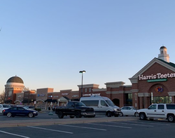
Wesley Chapel Village Commons, Wesley Chapel, North Carolina.png
Wesley Chapel Village Commons
Motto(s): 
"A Great Place to Live and Raise a Family"
USA North Carolina location map.svg
Red pog.svg
Wesley Chapel
Location of Wesley Chapel in North Carolina
Coordinates: 35°00′20″N80°40′04″W / 35.00556°N 80.66778°W / 35.00556; -80.66778
Country United States
State North Carolina
County Union
Incorporated1998 [1]
Named for Wesley's Chapel
Government
  MayorAmanda Fuller [2]
  CouncilMike Como, Lori Bailey, David Boyce, Deb Bledsoe
Area
[3]
  Total9.80 sq mi (25.39 km2)
  Land9.72 sq mi (25.17 km2)
  Water0.08 sq mi (0.22 km2)
Elevation
[4]
600 ft (200 m)
Population
 (2020)
  Total8,681
  Density893.20/sq mi (344.87/km2)
Time zone UTC-5 (Eastern (EST))
  Summer (DST) UTC-4 (EDT)
ZIP code
Area code(s) 704, 980
FIPS code 37-71940 [5]
GNIS feature ID2407569 [4]
Website www.ci.wesley-chapel.nc.us

Wesley Chapel is a village in Union County, North Carolina, United States. The population was 8,681 at the 2020 census and was estimated to be 8,883 in 2021. [6]

Contents

Geography

Wesley Chapel is located in the townships of Monroe and Sandy Ridge in eastern Union County, North Carolina. Part of the Charlotte metropolitan area, it sits east of Weddington, north of Waxhaw, west of Monroe, and south of Indian Trail. [7]

According to the United States Census Bureau, the village has a total area of 9.8 square miles (25.39 km2). It has a population density of 787.4 people per square mile. [8] The majority of the village's area is land, aside from Price Mill Creek and some small residential ponds.

NC-84 passes through the village as Weddington Road. The village's main attractions are its central business district, known as Wesley Chapel Village Commons, and Dogwood Park. [9]

History

The village of Wesley Chapel's existence can be traced back to the establishment of Wesley Chapel United Methodist Church, one of many United Methodist churches to be named after Methodism founder John Wesley's chapel in London. The Wesley Chapel church was founded in 1832 on the remains of an abandoned campground outside nearby Mineral Springs known as McWhorter Campground. The community became first recognized in the early 20th century as residents of Monroe and Vance Township in the early 20th century declared themselves as part of the Wesley Chapel vicinity of Sandy Ridge Township, taking the name from the Methodist church. [10]

The village was originally known as Price's Mill, named after the family of Joseph Price and his son James Newton Price. The Price family began as farmers but acquired a significant portion of the land of Wesley Chapel and contributed to much of the village's early development. [10]

James Newton Price served in the North Carolina General Assembly for four terms, during which he established Wesley Chapel High School in 1901 and served as the first director of the Wesley Chapel School District Board of Trustees. [11] Wesley Chapel High School was the first rural public high school in North Carolina. [12] The school burnt down in 1955 and reopened in 1961 as Wesley Chapel Elementary School following the opening of Sun Valley High School in Indian Trail. The school was destroyed in a fire and rebuilt again in 1966. [10]

Wesley Chapel was officially incorporated as a village of Union County in 1998. [10]

Demographics

Historical population
CensusPop.Note
2000 2,549
2010 7,463192.8%
2020 8,68116.3%
2021 (est.)8,8832.3%
U.S. Decennial Census [13]

2020 census

2020 racial makeup [6]
RaceNumberPercentage
White (non-Hispanic)6,84978.9%
Black or African American (non-Hispanic)6607.6%
Hispanic or Latino 6437.4%
Asian 2963.4%
Other/Mixed 2162.5%
Native American 170.2%
Pacific Islander 00.0%

As of the 2020 census, there were 2,707 households in Wesley Chapel with an average of 3.2 people per household. [6]

54.5% of the population was between the ages of 18 and 65. 29.9% were younger than 18, with 3.1% of those being younger than five. 12.5% are over the age of 65. 52.7% of residents were men, and 47.3% were women. [6]

96.2% of the population were homeowners, with the median home value being $368,200. The median income was $124,716 per the 2020 census. 3.3% of the population lives below the poverty line. [6]

66.2% of men and 53.1% of women in Wesley Chapel were employed. 85.7% of people above the age of 25 had a high school diploma, while 37.6% held a bachelor's degree or higher. [6]

2000 census

At the 2000 census there were 2,549 people, 867 households, and 762 families in the village. The population density was 302.8 inhabitants per square mile (116.9/km2). There were 912 housing units at an average density of 108.3 per square mile (41.8/km2). The racial makeup of the village was 97.02% White, 1.41% African American, 0.12% Native American, 0.31% Asian, 0.04% Pacific Islander, 0.35% from other races, and 0.75% from two or more races. Hispanic or Latino of any race were 1.88%. [5]

Of the 867 households 43.9% had children under the age of 18 living with them, 79.4% were married couples living together, 5.5% had a female householder with no husband present, and 12.0% were non-families. 9.3% of households were one person and 2.5% were one person aged 65 or older. The average household size was 2.94 and the average family size was 3.14. [5]

The age distribution was 29.1% under the age of 18, 6.2% from 18 to 24, 32.1% from 25 to 44, 25.9% from 45 to 64, and 6.7% 65 or older. The median age was 37 years. For every 100 females, there were 104.2 males. For every 100 females age 18 and over, there were 100.7 males. [5]

The median household income was $74,188 and the median family income was $73,000. Males had a median income of $41,620 versus $30,739 for females. The per capita income for the village was $30,143. About 4.1% of families and 3.4% of the population were below the poverty line, including 2.4% of those under age 18 and 10.4% of those age 65 or over. [5]
Related Research Articles

<span class="mw-page-title-main">Lamar County, Alabama</span> County in Alabama, United States

Lamar County is a county in the U.S. state of Alabama. As of the 2020 census, the population was 13,972. Its county seat is Vernon and it is a dry county. It is named in honor of Lucius Quintus Cincinnatus Lamar, a former Confederate officer and former member of both houses of the United States Congress from Mississippi.

<span class="mw-page-title-main">Union County, North Carolina</span> County in North Carolina, United States

Union County is a county located in the U.S. state of North Carolina. As of the 2020 census, the population was 238,267. Its county seat is Monroe. Union County is included in the Charlotte-Concord-Gastonia, NC-SC Metropolitan Statistical Area.

<span class="mw-page-title-main">Saxapahaw, North Carolina</span> Census-designated place in North Carolina, United States

Saxapahaw is a census-designated place (CDP) and unincorporated area in Alamance County, North Carolina, United States. It is part of the Burlington, North Carolina Metropolitan Statistical Area. The population was 1,648 at the 2010 census.

<span class="mw-page-title-main">Cedar Rock, North Carolina</span> Village in North Carolina, United States

Cedar Rock is a village in Caldwell County, North Carolina, United States. The population was 300 at the 2010 census.

<span class="mw-page-title-main">Mooresboro, North Carolina</span> Town in North Carolina, United States

Mooresboro is a town in Cleveland County, North Carolina, United States. The population was 311 at the 2010 census.

<span class="mw-page-title-main">Clemmons, North Carolina</span> Village in North Carolina

Clemmons is a village in Forsyth County, North Carolina, United States and a suburb of Winston-Salem. The population was 21,177 at the 2020 census, with an estimated population of 21,517 in 2021.

<span class="mw-page-title-main">Webster, North Carolina</span> Town in North Carolina, United States

Webster is a town in Jackson County, North Carolina, United States. As of the 2010 census, the population was 363, down from 486 in 2000.

<span class="mw-page-title-main">St. Helena, North Carolina</span> Village in North Carolina, United States

St. Helena or Saint Helena is a village in Pender County, North Carolina, United States. The population was 389 at the 2010 census. It is part of the Wilmington Metropolitan Statistical Area.

<span class="mw-page-title-main">Bethel, North Carolina</span> Town in North Carolina, United States

Bethel is a town in Pitt County, North Carolina, United States. The population was 1,577 at the 2010 census. The town is a part of the Greenville Metropolitan Area located in North Carolina's Inner Banks region. Confusingly, there are three other towns in the state named "Bethel." One is between Edenton and Hertford in the "Finger Counties" region in the northeastern corner of the state, another is in the north-central part, in Caswell County and the third is located in the Mountain Region of North Carolina, in Haywood County. There is also a community named Bethel located in Watauga County.

<span class="mw-page-title-main">Trinity, North Carolina</span> City in North Carolina, United States

Trinity is a city in Randolph County, North Carolina, United States. The population was 7,006 at the 2020 census. Trinity is part of the Greensboro-High Point Metropolitan Statistical Area of the Piedmont Triad metro region.

<span class="mw-page-title-main">Raynham, North Carolina</span> Town in North Carolina, United States

Raynham is a town in Robeson County, North Carolina, United States. The population was 72 at the 2010 census.

<span class="mw-page-title-main">Rutherfordton, North Carolina</span> Town in North Carolina, United States

Rutherfordton is a town and the county seat of Rutherford County, North Carolina, United States. The population was 4,213 at the 2010 census.

<span class="mw-page-title-main">Spindale, North Carolina</span> Town in North Carolina, United States

Spindale is a town in Rutherford County, North Carolina, United States. The population was 4,321 at the 2010 census.

<span class="mw-page-title-main">Wagram, North Carolina</span> Town in North Carolina, United States

Wagram is a town in Scotland County, North Carolina, United States. The population was 840 at the 2010 census. The town was named for the Battle of Wagram, a Napoleonic battle at Deutsch-Wagram in Austria.

<span class="mw-page-title-main">Lake Park, North Carolina</span> Village in North Carolina, United States

Lake Park is a village in Union County, North Carolina, United States. The population was 3,422 at the 2010 census.

<span class="mw-page-title-main">Unionville, North Carolina</span> Town in North Carolina, United States

Unionville is a rural town in Union County, North Carolina, United States. The population was 6,643 at the 2020 census.

<span class="mw-page-title-main">Pitsburg, Ohio</span> Village in Ohio, United States

Pitsburg is a village in Monroe Township, Darke County, Ohio, United States. The population was 381 at the 2020 census.

<span class="mw-page-title-main">Locust, North Carolina</span> City in North Carolina, United States

Locust is a small rural city in Stanly and Cabarrus counties in the U.S. state of North Carolina. The population was 2,930 at the 2010 census.

<span class="mw-page-title-main">Weddington, North Carolina</span> Town in North Carolina, United States

Weddington is a suburban town in Union County, North Carolina, United States. The population was 9,459 at the 2010 census. It is a suburb in the Charlotte metropolitan area. The current mayor of Weddington is Jim Bell.

<span class="mw-page-title-main">Denton, North Carolina</span> Town in North Carolina, United States

Denton is a town in Davidson County, North Carolina, United States. As of the 2020 census, the population of the town was 1,494.

References

  1. "North Carolina Gazetteer" . Retrieved November 24, 2023.
  2. "Mayor and Council". The Village of Wesley Chapel. December 2022.
  3. "ArcGIS REST Services Directory". United States Census Bureau. Retrieved September 20, 2022.
  4. 1 2 U.S. Geological Survey Geographic Names Information System: Wesley Chapel, North Carolina
  5. 1 2 3 4 5 "U.S. Census website". United States Census Bureau . Retrieved January 31, 2008.
  6. 1 2 3 4 5 6 "U.S. Census Bureau QuickFacts: Wesley Chapel village, North Carolina". www.census.gov. Retrieved April 11, 2023.
  7. "ArcGIS Web Application". ucnc-gis.maps.arcgis.com. Retrieved April 11, 2023.
  8. "Wesley Chapel NC - information about the village and its administration". www.citydirectory.us. Retrieved April 11, 2023.
  9. Wells, Ashley (November 4, 2020). "Top 10 Things To Do in Wesley Chapel, NC". LandMark Dentistry. Retrieved April 11, 2023.
  10. 1 2 3 4 Lee, Bill (July 15, 2008). "The History and Heritage of the Village of Wesley Chapel: Celebrating Ten Years as an Incorporated Municipality" (PDF). The Village of Wesley Chapel. Retrieved April 11, 2023.
  11. "Union County North Carolina Ancestral Trackers". www.ancestraltrackers.net. Retrieved April 12, 2023.
  12. "School Profile / Fast Facts". www.ucps.k12.nc.us. Retrieved April 12, 2023.
  13. "Census of Population and Housing". Census.gov. Retrieved June 4, 2015.