Related Research Articles
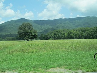
Cades Cove is an isolated valley located in the Tennessee section of the Great Smoky Mountains National Park. The valley was home to numerous settlers before the formation of the national park. Cades Cove, the single most popular destination for visitors to the park, attracts more than two million visitors annually because of its well preserved homesteads, scenic mountain views, and abundant display of wildlife. The Cades Cove Historic District is listed on the National Register of Historic Places.

Nutbush is a rural unincorporated community in Haywood County, Tennessee, United States, in the western part of the state, approximately 50 miles (80 km) north-east of Memphis. It was established in the early 19th century by European-American settlers, who bought enslaved African Americans to develop the area's cotton plantations. Houses and churches built during that time still stand.
Zephyr in an unincorporated community in western Surry County, North Carolina, United States. The community is centered on the intersection of Zephyr-Mountain Park Road and Poplar Springs Road/Zephyr Road and lies between the Mitchell River and Little Creek. Prominent landmarks in the center of the community include Gum Orchard Baptist Church and the Zephyr Cemetery.

Thurmond is an unincorporated community in north eastern Wilkes County, North Carolina, United States, along the border with Surry County.
Union Cross is an unincorporated community in the Dobson Township of central Surry County, North Carolina, United States. The community is roughly centered on the intersection of Dobbins Mill Road and Twin Oaks Road. Prominent landmarks include Union Cross Baptist Church, Union Cross Baptist Church cemetery, the Dockery Family Cemetery, and a local Ruritan club. The land for the Union Cross Ruritan Club was donated to the community for this purpose by Mrs. Minnie Shinault Dockery, widow of T. Alvin Dockery, a prominent local farmer and owner of the local general store. This Community is served by the Jot-Um-Down Volunteer Fire Department, which was founded in 1980.

West Union is an unincorporated community in Washington County, Oregon, United States. Founded in 1851, the community had the first school district in the county; it also contains the oldest cemetery in the state and the oldest Baptist church west of the Rocky Mountains. It is located north of Hillsboro near the intersection of West Union Road and Cornelius Pass Road north of the Sunset Highway. The name comes from a grove of five oak trees that was used as a meeting place of early settlers, or the "union of the west." West Union had a post office from 1874 to 1894.

Houston is an unincorporated community in Wayne County, Tennessee.

The Antioch Missionary Baptist Church Cemetery is located at 500 North McKinney Road in Sherrill, Arkansas, behind the Antioch Missionary Baptist Church. The earliest graves contain the remains of emancipated slaves, originally enslaved on the Good Hope Plantation in South Carolina, but moved to Jefferson County, Arkansas in 1860. Reverenced Lewis Mazique, a leader in the community, was the earliest documented burial, in 1885. The cemetery continues to be used today, although infrequently.
Norrington is an unincorporated community located in Harnett County, North Carolina, United States. It is an African American community located a few miles south of Lillington, the county seat, and west of Bunnlevel. The community was settled as early as the 1860s.

Gilmore is an unincorporated community in Le Flore County, Oklahoma, United States. The town, formerly incorporated, boasted a small post office, city hall, and Mayor Pratt McMillin, a rancher and oil distributor who died in April 2001, aged 84.

Turnersburg Township is a nonfunctioning administrative division in northeastern Iredell County, North Carolina, United States. Turnersburg township was established in 1868. The only major town in Turnersburg township is Harmony, which is also partially within Eagle Mills township.
Chambersburg Township is a township in Iredell County, North Carolina, United States. The 2010 United States Census reported a total population of 11,344.
Sharpesburg Township is a non-functioning administrative division of Iredell County, North Carolina, United States. By the requirements of the North Carolina Constitution of 1868, the counties were divided into townships, which included Sharpesburg township as one of sixteen townships in Iredell county.

Cool Springs Township is a non-functioning administrative division of Iredell County, North Carolina, United States. By the requirements of the North Carolina Constitution of 1868, the counties were divided into townships, which included Cool Springs township as one of sixteen townships in Iredell County.
Eagle Mills Township is a rural, non-functioning subdivision of Iredell County, North Carolina, United States. By the requirements of the North Carolina Constitution of 1868, the counties were divided into townships, which included Eagle Mills. Eagle Mills Township was named for the town of Eagle Mills, which was established by Andrew Baggerly on Hunting Creek in 1848.
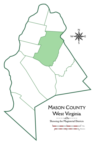
Cooper Magisterial District is one of ten magisterial districts in Mason County, West Virginia, United States. The district was originally established as a civil township in 1863, and converted into a magisterial district in 1872. In 2020, Cooper District was home to 1,700 people.
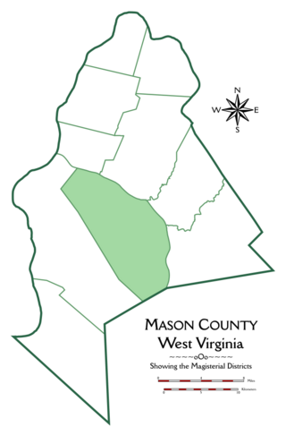
Arbuckle Magisterial District is one of ten magisterial districts in Mason County, West Virginia, United States. The district was originally established as a civil township in 1863, and converted into a magisterial district in 1872. In 2020, Arbuckle District was home to 1,054 people.
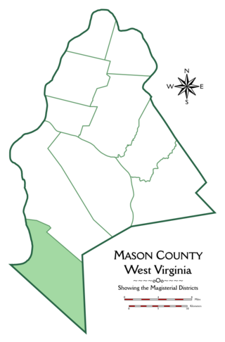
Hannan Magisterial District is one of ten magisterial districts in Mason County, West Virginia, United States. The district was originally established as a civil township in 1863, and converted into a magisterial district in 1872. In 2020, Clendenin District was home to 2,688 people.
References
- ↑ U.S. Geological Survey Geographic Names Information System: Olive Branch, North Carolina
- ↑ "Olive Branch Populated Places Profile" . Retrieved October 13, 2023.
- ↑ "They Lived Along a Rocky River" . Retrieved October 13, 2023.
Municipalities and communities of Union County, North Carolina, United States | ||
|---|---|---|
| City |  | |
| Towns | ||
| Villages | ||
| CDP | ||
| Other communities | ||
| Ghost town | ||
| Footnotes | ‡This populated place also has portions in an adjacent county or counties | |