Winterville, North Carolina

Last updated

Winterville, North Carolina
Winterville, North Carolina.jpg
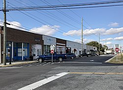
Commercial buildings along Railroad Street
Nickname(s): 
Dub-V; WV; Pinebelt Boomtown
Motto: 
"A slice of the good life!"
NCMap-doton-Winterville.PNG
Location of Winterville, North Carolina
Coordinates: 35°31′45″N77°24′00″W / 35.52917°N 77.40000°W / 35.52917; -77.40000
CountryUnited States
State North Carolina
County Pitt
Government
   Mayor Ricky Hines
Area
[1]
  Total4.93 sq mi (12.78 km2)
  Land4.93 sq mi (12.77 km2)
  Water0.00 sq mi (0.00 km2)
Elevation
[2]
69 ft (21 m)
Population
 (2020)
  Total10,462
  Density2,121.25/sq mi (819.01/km2)
Time zone UTC−5 (Eastern (EST))
  Summer (DST) UTC−4 (EDT)
ZIP code
28590
Area code 252
FIPS code 37-75060 [3]
GNIS feature ID2406905 [2]
Website http://www.wintervillenc.com/

Winterville is a town in Pitt County, North Carolina, United States. The population was 10,591 as of the 2020 census. [4] The town is a part of the Greenville Metropolitan Area.

Contents

History

The Cox-Ange House and Renston Rural Historic District are listed on the National Register of Historic Places. [5]

Geography

According to the United States Census Bureau, the town has a total area of 4.6 square miles (12 km2), all land. [4]

Demographics

Historical population
CensusPop.Note
1900 243
1910 48499.2%
1920 65034.3%
1930 6540.6%
1940 84829.7%
1950 8702.6%
1960 1,41863.0%
1970 1,4371.3%
1980 2,05242.8%
1990 2,81637.2%
2000 4,79170.1%
2010 9,26993.5%
2020 10,59114.3%
U.S. Decennial Census [6]

2020 census

Winterville racial composition [4]
RaceNumberPercentage
White (non-Hispanic)6,31460.6%
Black or African American (non-Hispanic)3,42832.9
Native American 00.0%
Asian 1461.4%
Pacific Islander 00.00%
2 or More Races 3653.5%
Hispanic or Latino 3753.6%

As of the 2020 United States census, there were 10,419 people, 4,143 households, and 2,759 families residing in the town.

2010 census

As of 2010, there were 9269 people, 1,848 households, and 1,371 families living in the town. The population density was 1,954.1 inhabitants per square mile (754.5/km2). There were 1,937 housing units at an average density of 790.0 per square mile (305.0/km2). The racial makeup of the town was 59.24% White, 38.36% African American, 0.35% Native American, 0.81% Asian, 0.10% Pacific Islander, 0.40% from other races, and 0.73% from two or more races. Hispanic or Latino of any race were 1.02% of the population.

Of the 1,848 households 38.6% had children under the age of 18 living with them, 53.6% were married couples living together, 17.5% had a female householder with no husband present, and 25.8% were non-families. 22.6% of households were one person and 7.6% were one person aged 65 or older. The average household size was 2.57 and the average family size was 3.01.

The age distribution was 28.0% under the age of 18, 7.9% from 18 to 24, 34.3% from 25 to 44, 19.7% from 45 to 64, and 10.2% 65 or older. The median age was 33 years. For every 100 females, there were 84.3 males. For every 100 females age 18 and over, there were 79.6 males.

The median household income was $37,230 and the median family income was $47,167. Males had a median income of $36,004 versus $30,000 for females. The per capita income for the town was $19,810. About 10.3% of families and 11.6% of the population were below the poverty line, including 16.4% of those under age 18 and 12.4% of those age 65 or over.

Education

Parks and recreation

Winterville Parks and Recreation has four baseball fields, an amphitheater for concerts and Movie in the Park events; it also features a mile-long trail around the park. Winterville Baseball is part of The Cal Ripken League and has succeeded in All-Star tournaments over the last decade.

Growth

In recent years, the town of Winterville has experienced major growth both residentially and commercially. Since the 1990s, subdivisions such as Winterville Crossing, Cedar Ridge, Irish Creek and many others surrounding the area have sprouted.

Notable people

Related Research Articles

<span class="mw-page-title-main">Pitt County, North Carolina</span> County in North Carolina, United States

Pitt County is a county located in the Inner Banks region of the U.S. state of North Carolina. As of the 2020 census, the population was 170,243, making it the fourteenth-most populous county in North Carolina. Its county seat is Greenville.

<span class="mw-page-title-main">Pinetops, North Carolina</span> Town in North Carolina, United States

Pinetops is a town in Edgecombe County, North Carolina, United States. It is part of the Rocky Mount, North Carolina Metropolitan Statistical Area. The population was 1,374 at the 2010 census.

<span class="mw-page-title-main">Hookerton, North Carolina</span> Town in North Carolina, United States

Hookerton is a town in Greene County, North Carolina, United States. The population was 409 at the 2010 census. It is geographically located southeast of Snow Hill on North Carolina Highway 123. The town is part of the Greenville Metropolitan Area.

<span class="mw-page-title-main">Snow Hill, North Carolina</span> Town in North Carolina, United States

Snow Hill is a town in Greene County, North Carolina, United States. The population was 1,595 at the 2010 census. It is the county seat of Greene County and is part of the Greenville Metropolitan Area. Snow Hill hosts numerous tennis tournaments during the year. Snow Hill is home to the Green Ridge Racquet Club. Many junior players and adults travel to Snow Hill in order to play in the USTA Sanctioned tournaments.

<span class="mw-page-title-main">Walstonburg, North Carolina</span> Town in North Carolina, United States

Walstonburg is a town in Greene County, North Carolina, United States. The population was 219 at the 2010 census. It is located north of Snow Hill on North Carolina Highway 91. The town is part of the Greenville Metropolitan Area.

<span class="mw-page-title-main">Ayden, North Carolina</span> Town in North Carolina, United States

Ayden is a town in Pitt County, North Carolina, United States. The population was 4,977 at the 2020 census. The town is a part of the Greenville Metropolitan Area of North Carolina's Inner Banks region.

<span class="mw-page-title-main">Bethel, North Carolina</span> Town in North Carolina, United States

Bethel is a town in Pitt County, North Carolina, United States. The population was 1,577 at the 2010 census. The town is a part of the Greenville Metropolitan Area located in North Carolina's Inner Banks region. Confusingly, there are three other towns in the state named "Bethel." One is between Edenton and Hertford in the "Finger Counties" region in the northeastern corner of the state, another is in the north-central part, in Caswell County and the third is located in the Mountain Region of North Carolina, in Haywood County. There is also a community named Bethel located in Watauga County.

<span class="mw-page-title-main">Falkland, North Carolina</span> Town in North Carolina, United States

Falkland is a town in Pitt County, North Carolina, United States. The population was 96 at the 2010 census, making it the least populous town in Pitt County. The town is a part of the Greenville Metropolitan Area located in North Carolina's Inner Banks region.

<span class="mw-page-title-main">Farmville, North Carolina</span> Town in North Carolina, United States

Farmville is a town in Pitt County, North Carolina, United States, eight miles to the west of Greenville. At the 2010 census, the population was 4,654. Farmville is a part of the Greenville Metropolitan Area located in North Carolina's Inner Banks region. Farmville has been a Tree City USA community through the Arbor Day Foundation for 36 years, proving its commitment to managing and expanding its public trees. The Town government, in cooperation with other non-profit groups that work for the advancement of the town, sponsor annual events such as the Farmville Dogwood Festival, the Christmas Parade, Independence Day Celebration, A Taste of Farmville, and the Holiday Open House, among others.

<span class="mw-page-title-main">Fountain, North Carolina</span> Town in North Carolina, United States

Fountain is a town in Pitt County, North Carolina, United States. The population was 427 at the 2010 census. The town is a part of the Greenville Metropolitan Area located in North Carolina's Inner Banks region.

<span class="mw-page-title-main">Grimesland, North Carolina</span> Town in North Carolina, United States

Grimesland is a town in Pitt County, North Carolina, United States. The population was 441 at the 2010 census. The town is a part of the Greenville Metropolitan Area located in North Carolina's Inner Banks.

<span class="mw-page-title-main">Creswell, North Carolina</span> Town in North Carolina, United States

Creswell is a town in Washington County, North Carolina, United States. The population was 276 at the 2010 census.

<span class="mw-page-title-main">Blacksburg, South Carolina</span> Town in South Carolina, United States

Blacksburg is a small town in Cherokee County, South Carolina, United States. The population was 1,848 at the 2010 census. The communities of Cherokee Falls, Kings Creek, Cashion Crossroads, Buffalo, and Mount Paran are located near the town.

<span class="mw-page-title-main">Mauldin, South Carolina</span> City in South Carolina, United States

Mauldin is a city in Greenville County, South Carolina. The population was 24,724 at the 2020 census. It is a principal city of the Greenville, SC Metropolitan Statistical Area.

Wade Hampton is a census-designated place (CDP) in Greenville County, South Carolina, United States. The population was 20,622 at the 2010 census. It is named for American Civil War general and South Carolina governor Wade Hampton.

<span class="mw-page-title-main">Gilbert, South Carolina</span> Town in South Carolina, United States

Gilbert is a town in Lexington County, South Carolina, United States. The population was 569 at the 2010 census. It is part of the Columbia, South Carolina Metropolitan Statistical Area.

<span class="mw-page-title-main">Pickens, South Carolina</span> City in South Carolina, United States

Pickens, formerly called Pickens Courthouse, is a city in and the county seat of Pickens County, South Carolina, United States. The population was 3,126 at the 2010 census. Pickens changed its classification from a town to a city in 1998, but it was not reported to the Census Bureau until 2001. It was named after Andrew Pickens (1739–1817), an American revolutionary soldier and US Congressman for South Carolina.

<span class="mw-page-title-main">Piedmont, South Carolina</span> CDP in South Carolina, United States

Piedmont is a census-designated place (CDP) along the Saluda River in Anderson and Greenville counties in the U.S. state of South Carolina. The population was 5,411 at the 2020 census.

<span class="mw-page-title-main">Winterville, Georgia</span> City in Georgia, United States

Winterville is a village in Clarke County, Georgia, United States. The population was 1,122 at the 2010 census.

The Greenville-Washington, NC Combined Statistical Area, as defined by the United States Census Bureau, is an area consisting of seven counties in Eastern North Carolina. As of the 2011 census estimate, the CSA had a population of 427,723, compared to 399,848 in the 2009 census estimate.

References

  1. "ArcGIS REST Services Directory". United States Census Bureau. Retrieved September 20, 2022.
  2. 1 2 U.S. Geological Survey Geographic Names Information System: Winterville, North Carolina
  3. "U.S. Census website". United States Census Bureau . Retrieved January 31, 2008.
  4. 1 2 3 "U.S. Census Bureau QuickFacts: Winterville town, North Carolina". www.census.gov. United States Census Bureau. Retrieved June 7, 2022.
  5. "National Register Information System". National Register of Historic Places . National Park Service. July 9, 2010.
  6. "Census of Population and Housing". Census.gov. Retrieved June 4, 2016.