Eastern North Carolina

Last updated
One interpretation of North Carolina's regions NC regions.png
One interpretation of North Carolina's regions
North Carolina Eastern Region Enc map.png
North Carolina Eastern Region

Eastern North Carolina (sometimes abbreviated as ENC) is the region encompassing the eastern tier of North Carolina, United States. It is known geographically as the state's Coastal Plain region. Primary subregions of Eastern North Carolina include the Sandhills, the Lower Cape Fear (Wilmington Area), the Crystal Coast, the Inner Banks and the Outer Banks. It is composed of the 41 most eastern counties in the state. Cities include Greenville, Jacksonville, Wilmington, Rocky Mount and North Carolina's first capital New Bern.

Contents

In 1993, the State Legislature established seven regional economic development organizations and three of these serve eastern North Carolina - Northeast North Carolina Commission (covering 16 counties), North Carolina East Alliance (representing 13 counties surrounding North Carolina's Global TransPark), and North Carolina's Southeast Commission (assisting 11 counties).

New transitions are being made in the geography of the economic sectors. Economic Development Commissions are transforming, such as North Carolina's Eastern Region Commission's transition into North Carolina East Alliance. Different EDC's have different ways to increase prosperity in the area. NCEA's first focus is to improve the talent pipeline to create a more comprehensive local workforce. Shoop, the Commissioner for Washington's EDC stated "In a private setting, they would be able to access different funds for additional economic projects or initiatives in the county." [1]

Located east of the Piedmont and west of the Atlantic Ocean, Eastern North Carolina contains very few major urban centers. Greenville is close to the region's geographic center. Fayetteville is the largest city in the region, followed by Wilmington and Greenville.

Geography

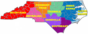
Eastern North Carolina is roughly made up of the 44 easternmost counties in North Carolina. Generally, the region denotes all of the state's counties on and east of Interstate 95 (also known as East Coast USA Main Street stretching from northern Maine to the southern tip of Florida). If defined by geological formations, eastern North Carolina comprises the 44 counties of the Inner and Outer Coastal Plains. In terms of economic similarities, the region includes 41 counties. The commonly accepted definition is all counties east of and crossed by Interstate 95, which is 41 counties. I-95 intersects with US64/264 at Wilson County and is in close proximity to I-40. This makes transportation throughout the region incredible along with easy access to the rest of the state and country. The region is further divisible into three geographic sections: the Southeast, Inner Banks and the Outer Banks.

History

The coast of North Carolina were dominated by Native Americans, primarily the Tuscarora people residing near modern Snow Hill. Eastern North Carolina is also home to the first attempted English settlement in the New World on Roanoke Island.

During the colonial era of American History, the East was the dominant region of North Carolina in both government and commerce. Towns of early significance included Bath, Beaufort, Elizabeth City, Edenton, Kinston, New Bern, Tarboro, and Wilmington. North Carolina's early economy was built upon cash crops, fisheries and turpentine industries. Early East Carolinians lived on settlements at the mouths of the various rivers. Settlers to the regions were of English, Scottish, Swiss and German descent. Eastern North Carolina was a haven for pirating and home to the infamous pirate Blackbeard. The city of New Bern was founded in 1710 by settlers from the Palantine region of Germany, and later became the colonial capital. Around the end of the eighteenth century, however, such dominance shifted to the Piedmont center of the state.

The growth in population of the western and piedmont regions of North Carolina after the American Revolution led to revisions of the Constitution of North Carolina in 1835. These amendments included electing the governor by popular vote. [2]

Education

Four-year institutions

The region is dotted with universities. There are five public universities and seven private institutions in the region. The largest is East Carolina University, a Doctoral University with Higher Research Activity on the Carnegie scale. The four other public universities are Elizabeth City State University, Fayetteville State University, University of North Carolina at Pembroke, and University of North Carolina at Wilmington. The seven private institutions are: Barton College, Campbell University, Chowan University, Methodist University, University of Mount Olive, North Carolina Wesleyan College, and Mid-Atlantic Christian University.

Community colleges

The area is also served by 23 community colleges. The two-year institutes are: Beaufort County Community College, Bladen Community College, Brunswick Community College, Cape Fear Community College, Carteret Community College, College of the Albemarle, Coastal Carolina Community College, Craven Community College, Edgecombe Community College, Fayetteville Technical Community College, James Sprunt Community College, Johnston Community College, Lenoir Community College, Roanoke-Chowan Community College, Martin Community College, Nash Community College, Pamlico Community College, Pitt Community College, Sampson Community College, Sandhills Community College, Southeastern Community College, Wayne Community College, and Wilson Community College.

Many community colleges hold programs to create a more able workforce in Eastern North Carolina. The different economic clusters, including but not limited to advanced manufacturing (aerospace, automotive and industrial machinery), life sciences (Biopharma and medical device research, development and manufacturing), value-added agriculture (food processing, forest products, etc.) and marine products (boat building) have prompted Community Colleges to offer associate degrees in related fields (e.g. Airframe/power plant maintenance, composite technology, engineering technology, biotechnology and pharmaceutical manufacturing technology, machining and welding).

Transportation

Eastern North Carolina is served by two main interstate highways and a number of U.S. routes.

Road Transportation

Over 60 motor freight carriers provide service to all parts of the nation.

FedEx, UPS, DHL and Emery have offices in all major communities.

The transportation within the region allows for easy access to anywhere in the continental United States of America. I-40 and I-95 are capable of this with close proximity to I-85 as well. Manufacturers can move their goods efficiently and families can travel with ease.

Much of the region's main highways have been designated as the Historic Albemarle Tour, which connects many historic sites in Eastern North Carolina.

Rail Transportation

CSX, Norfolk Southern Railway, and the North Carolina Railroad Company serve the industries within the region. The National Railroad Passenger Corporation, Amtrak, is a train service for passengers. Amtrak passenger stations are located in Rocky Mount, Wilson, Selma, Fayetteville and throughout North Carolina and the Eastern region.

Air Transportation

Wilmington International Airport is in Eastern North Carolina along with RDU within a short driving distance. Raleigh-Durham International can be reached via i-40 (with i-440 or 540 being additional options). There are several ways to access Wilmington International easily when in the region, using i-40 or US-17.

There are also sixteen regional airports that serve general aviation in the Eastern region of North Carolina: Greenville, Jacksonville and New Bern provide commuter service to Charlotte, Atlanta, Cincinnati and Philadelphia.

Global Transpark

The North Carolina Global TransPark (GTP) is a 2,500 acre, multi-modal industrial park. [3]

Ports

There are deep-water bulk, break-bulk cargo and container facilities in ENC at Morehead City, NC and Wilmington, NC. A third comprehensive deep-water (Panamx-ready) port exists just north of the state line in Norfolk/Portsmouth, VA. All three ports also have RoRo (roll-on, roll-off) facilities to handle autos and military equipment.

Government

The local government of Eastern North Carolina is served by seven of the 16 North Carolina Councils of Government. They include the Upper Coastal Plain Council of Governments, Mid-Carolina Council of Governments, Lumber River Council of Governments, Cape Fear Council of Governments, Eastern Carolina Council of Governments, Mid-East Commission, and the Albemarle Commission.

Socio-economic

Eastern North Carolina is by and large an impoverished area. Nearly 21 percent of people live in poverty in this region[ citation needed ]. Outsourcing of textile manufacturing jobs along with other manufacturing jobs has caused unemployment in the area to increase particularly in the northeastern area of the state. Many areas of Eastern North Carolina are experiencing little economic growth; however, areas such as Greenville and Winterville (Pitt County) are growing rapidly due to the location of East Carolina University and its associated medical facilities. Fleet Readiness Center East on board Marine Corps Air Station Cherry Point is the largest industrial employer east of Interstate-95, with an annual payroll of $277 Million. [4]

Topography

Eastern North Carolina is located in the coastal plain region of the eastern seaboard of the United States and has relatively flat land that is primarily used for farming. The Outer Banks and Inner Banks are comparable to the tidewater region of Virginia in terms of land. However, the barrier islands of the Outer Banks are highly rare.

Area

Eastern North Carolina generally consists of 41 counties, which when combined form a total regional area of roughly 9,700 square miles (25000 square km). The counties commonly included in the region are as follows: [5]

  1. Bertie County
  2. Beaufort County
  3. Bladen County
  4. Brunswick County
  5. Camden County
  6. Carteret County
  7. Chowan County
  8. Columbus County
  9. Craven County
  10. Cumberland County
  11. Currituck County
  12. Dare County
  13. Duplin County
  14. Edgecombe County
  15. Gates County
  16. Greene County
  17. Halifax County
  18. Harnett County
  19. Hertford County
  20. Hoke County
  21. Hyde County
  22. Johnston County
  23. Jones County
  24. Lenoir County
  25. Martin County
  26. Nash County
  27. New Hanover County
  28. Northampton County
  29. Onslow County
  30. Pamlico County
  31. Pasquotank County
  32. Pender County
  33. Perquimans County
  34. Pitt County
  35. Robeson County
  36. Sampson County
  37. Scotland County
  38. Tyrrell County
  39. Washington County
  40. Wayne County
  41. Wilson County

Cities and towns

Eastern North Carolina communities in the region include:

Over 50,000 in population

Fewer than 50,000 population

Related Research Articles

<span class="mw-page-title-main">Interstate 95</span> U.S. East Coast Interstate Highway

Interstate 95 (I-95) is the main north–south Interstate Highway on the East Coast of the United States, running from U.S. Route 1 (US 1) in Miami, Florida, north to the Houlton–Woodstock Border Crossing between Maine and the Canadian province of New Brunswick. The highway largely parallels the Atlantic coast and US 1, except for the portion between Savannah, Georgia, and Washington, D.C., and the portion between Portland and Houlton in Maine, both of which follow a more direct inland route.

<span class="mw-page-title-main">Tarboro, North Carolina</span> Town in North Carolina, United States

Tarboro is a town located in Edgecombe County, North Carolina, United States. It is part of the Rocky Mount Metropolitan Statistical Area. As of the 2020 census, the town had a population of 10,721. It is the county seat of Edgecombe County. The town is on the opposite bank of the Tar River from Princeville. It is also part of the Rocky Mount-Wilson-Roanoke Rapids CSA. Tarboro is located near the western edge of North Carolina's coastal plain. It has many historical churches, some dating from as early as 1742.

<span class="mw-page-title-main">U.S. Route 13</span> Highway in the United States

U.S. Route 13 or U.S. Highway 13 (US 13) is a north–south United States Numbered Highway established in 1926 that runs for 518 miles (834 km) from Interstate 95 (I-95) just north of Fayetteville, North Carolina, to US 1 in the northeastern suburbs of Philadelphia, Pennsylvania, near Morrisville. In all, it traverses five states in the Atlantic coastal plain region. It follows the Atlantic coast more closely than does the main north–south U.S. Highway of the region, US 1. Due to this, its number is out of place on the general U.S. Highway numbering grid, as it should be running west of US 11 but does not. Its routing is largely rural, the notable exceptions being the Hampton Roads area in Virginia and the northern end of the highway in Delaware and Pennsylvania. It is also notable for being the main thoroughfare for the Delmarva Peninsula and carrying the Chesapeake Bay Bridge–Tunnel to it in Virginia.

<span class="mw-page-title-main">U.S. Route 64</span> Highway in the United States

U.S. Route 64 is an east–west United States highway that runs for 2,281 miles (3,672 km) from Nags Head in eastern North Carolina to just southwest of the Four Corners in northeast Arizona. The western terminus is at U.S. Route 160 in Teec Nos Pos, Arizona. The highway's eastern terminus is at NC 12 and U.S. Route 158 at Whalebone Junction, North Carolina. Major cities served along US 64's route include Tulsa, Oklahoma, Conway, Arkansas, Memphis and Chattanooga, Tennessee, and Raleigh and Rocky Mount, North Carolina.

<span class="mw-page-title-main">U.S. Route 258</span> U.S. Highway in North Carolina and Virginia

U.S. Route 258 is a spur of US 58 in the U.S. states of North Carolina and Virginia. The U.S. Highway runs 220.15 miles (354.30 km) from US 17 Business and NC 24 Business in Jacksonville, North Carolina north to Virginia State Route 143 at Fort Monroe in Hampton, Virginia. In North Carolina, US 258 connects Jacksonville with the Inner Banks communities of Kinston, Snow Hill, Farmville, Tarboro, and Murfreesboro. The U.S. Highway continues through the Virginia city of Franklin, where the highway intersects US 58, and the town of Smithfield on its way to the Hampton Roads metropolitan area. US 258 crosses the James River on the James River Bridge and follows Mercury Boulevard through Newport News and Hampton.

<span class="mw-page-title-main">United States District Court for the Eastern District of North Carolina</span> United States federal district court in North Carolina

The United States District Court for the Eastern District of North Carolina is the United States district court that serves the eastern 44 counties in North Carolina. Appeals from the Eastern District of North Carolina are taken to the United States Court of Appeals for the Fourth Circuit.

<span class="mw-page-title-main">North Carolina Highway 58</span> State highway in North Carolina, US

North Carolina Highway 58 (NC 58) is a primary state highway in the U.S. state of North Carolina that traverses the state's Coastal Plain. The route links many of the Crystal Coast communities along its eastern segment. Its southern terminus is at the visitor center parking lot for Fort Macon State Park in Atlantic Beach and its northern terminus is at the intersection of US 401 and US 158 Business in Warrenton. The highway traverses nearly the entire length of the Bogue Banks and serves the major cities of Kinston, Snow Hill, and Wilson.

<span class="mw-page-title-main">Inner Banks</span>

The Inner Banks is a neologism made up by developers and tourism promoters to describe the inland coastal region of eastern North Carolina. Without historical precedent, the term "Inner Banks" is an early 21st-century construct that is part of an attempt to rebrand the mostly agrarian coastal plain east of I-95 as a more attractive region for visitors and retirees.

<span class="mw-page-title-main">North Carolina Highway 11</span> State highway in North Carolina, US

North Carolina Highway 11 is a primary state highway in the U.S. state of North Carolina. Traveling 193.2 miles (310.9 km) in a north–south alignment through Eastern North Carolina, it connects the towns and cities of Wallace, Kenansville, Kinston, Greenville and Murfreesboro.

<span class="mw-page-title-main">Interstate 95 Business (North Carolina)</span> Highway in North Carolina

Interstate 95 Business is a business loop of I-95 entirely within Cumberland County, North Carolina. It runs from nearby Hope Mills to Eastover, passing through the eastern side of downtown Fayetteville.

The Eastern Carolina League was a minor league baseball affiliation which operated in the Eastern part of North Carolina. The league had two distinct periods of operation: 1908 to 1910 and a revival of the league in 1928 and 1929. It was classified as a Class D level league.

<span class="mw-page-title-main">Episcopal Diocese of East Carolina</span> Diocese of the Episcopal Church in the United States

The Episcopal Diocese of East Carolina is a diocese of the Episcopal Church in the United States that covers most of eastern North Carolina. The diocese was formed from the existing Diocese of North Carolina on October 9, 1883, by action of the General Convention of the Episcopal Church. It consists of the congregations of the Episcopal Church in the eastern portion of the state of North Carolina and forms part of Province IV of the Episcopal Church. Major cities of the diocese include Wilmington, Fayetteville, New Bern, and Greenville. Originally its offices were located in Wilmington, but in 1983 a new diocesan house was built in Kinston, North Carolina, in order to be located more centrally in the diocese's territory. The diocese's current bishop is Robert Skirving.

<span class="mw-page-title-main">History of East Carolina University</span>

East Carolina University can trace its roots to 1901 when City of Wilson citizens went to Raleigh to petition the N.C. General Assembly for an Eastern North Carolina Normal College. The delegation wanted the Normal College in Wilson. The request was denied because the politicians did not want to take money away from the State Normal College.

<span class="mw-page-title-main">North Carolina Highway 33</span> State highway in North Carolina, US

North Carolina Highway 33 (NC 33) is a primary state highway in the U.S. state of North Carolina. Spanning a distance of 110 miles (180 km), the east–west route passes through many small towns and communities in Eastern North Carolina's Inner Banks. It bypasses a large portion of the cities of Rocky Mount and Greenville, and goes through central Tarboro.

<span class="mw-page-title-main">U.S. Route 70 in North Carolina</span> Highway in North Carolina

U.S. Route 70 (US 70) is a part of the United States Numbered Highway System that runs from Globe, Arizona, to the Crystal Coast of the US state of North Carolina. In North Carolina, it is a major 488-mile-long (785 km) east–west highway that runs from the Tennessee border to the Atlantic Ocean. From the Tennessee state line near Paint Rock to Asheville it follows the historic Dixie Highway, running concurrently with US 25. The highway connects several major cities including Asheville, High Point, Greensboro, Durham, Raleigh, Goldsboro, and New Bern. From Beaufort on east, US 70 shares part of the Outer Banks Scenic Byway, a National Scenic Byway, before ending in the community of Atlantic, located along Core Sound.

<span class="mw-page-title-main">U.S. Route 13 in North Carolina</span> Highway in North Carolina

U.S. Route 13 (US 13) is a United States Numbered Highway running from Eastover, North Carolina to Morrisville, Pennsylvania. In North Carolina, it runs along a northeast–southwest alignment for 189.1 miles (304.3 km) connecting the cities of Fayetteville, Goldsboro, Greenville, Williamston, and Ahoskie. The southern terminus is located at Interstate 95 (I-95) and I-295 near Eastover. From the terminus, US 13 travels along a northeastern–southwestern alignment through Newton Grove to US 117 in Mar-Mac. US 13 runs concurrently along US 117 north to Goldsboro, where it also shares a brief concurrency with US 70. The highway continues northeastward to Greenville and then turns to the north until reaching US 64 near Bethel. US 13 and US 64 run concurrently to the east until Williamston where US 13 diverges to the north, concurrent with US 17. In Windsor, US 13 diverges from US 17 and runs northward through Ahoskie. US 13 turns to the northeast near Winton and continues in that direction until reaching the Virginia state line near Gates.

In North Carolina, Down East refers to two areas of Eastern North Carolina. The first is the historical group of coastal communities east of Beaufort in Carteret County. The second is anywhere east of I-95 in North Carolina in the coastal plain region.

This article is intended to give an overview of transportation in North Carolina.

<span class="mw-page-title-main">Interstate 587 (North Carolina)</span> Interstate Highway in North Carolina

Interstate 587 (I-587) is a 37.07-mile (59.66 km) auxiliary Interstate Highway in the US state of North Carolina. The western terminus of the highway is at I-95, I-795, and US Highway 264 (US 264) near Wilson. The highway runs concurrently with I-795 and US 264 around the southern side of Wilson. I-795 diverges toward Goldsboro 4.4 miles (7.1 km) east of I-95. The eastern end of the US 264 overlap is located northwest of Saratoga. I-587 continues travelling east, bypassing Saratoga and Farmville to the north. The eastern terminus of I-587 is located at US 264 and North Carolina Highway 11 Bypass in western Greenville. I-587 is a spur of the North Carolina segment of I-87 which runs from Raleigh to Wendell. As of 2023, I-587 does not connect with its parent route.

References

  1. "2002-12-30/news/25132636_1_edc-board-private-status-fort-ritchie". Herald Mail. December 30, 2002. Archived from the original on 2013-10-30. Retrieved 2014-02-24.
  2. Cockrell, David L. (2006). "East-West Rivalry". NCPEDIA. Retrieved November 5, 2019.
  3. "North Carolina Global Transpark".
  4. "Fleet Readiness Center". www.navair.navy.mil. Archived from the original on 2010-12-27.
  5. North Carolina Department of Public Instruction (ed.). "Our State Geography". NCPEDIA. Retrieved November 5, 2019.