Bridgeton, North Carolina

Last updated

Bridgeton, North Carolina
NCMap-doton-Bridgeton.PNG
Location of Bridgeton, North Carolina
Coordinates: 35°07′13″N77°00′50″W / 35.12028°N 77.01389°W / 35.12028; -77.01389
Country United States
State North Carolina
County Craven
Area
[1]
  Total2.05 sq mi (5.31 km2)
  Land2.05 sq mi (5.30 km2)
  Water0.00 sq mi (0.01 km2)
Elevation
[2]
7 ft (2 m)
Population
 (2020)
  Total349
  Density170.49/sq mi (65.84/km2)
Time zone UTC-5 (Eastern (EST))
  Summer (DST) UTC-4 (EDT)
ZIP code
28519
Area code 252
FIPS code 37-07860 [3]
GNIS feature ID2405319 [2]
Website www.townofbridgeton.org

Bridgeton is a town in Craven County, North Carolina, United States. The population was 454 at the 2010 census. [4] It is part of the New Bern, North Carolina Micropolitan Statistical Area.

Contents

Geography

Bridgeton is located on the eastern shore of the Neuse River, directly across from the city of New Bern, the Craven County seat. U.S. Route 17 passes through the town and connects to New Bern via the massive Neuse River Bridge (opened 1999) across the Neuse River just south of the town limits. [5]

According to the United States Census Bureau, the town has a total area of 1.5 square miles (4.0 km2), of which 0.004 square miles (0.01 km2), or 0.27%, is water. [4]

Demographics

Historical population
CensusPop.Note
1910 348
1920 54857.5%
1930 72131.6%
1940 616−14.6%
1950 80530.7%
1960 638−20.7%
1970 520−18.5%
1980 461−11.3%
1990 453−1.7%
2000 328−27.6%
2010 45438.4%
2020 349−23.1%
U.S. Decennial Census [6]

2020 census

Bridgeton racial composition [7]
RaceNumberPercentage
White (non-Hispanic)26676.22%
Black or African American (non-Hispanic)4914.04%
Native American 20.57%
Pacific Islander 10.29%
Other/Mixed 154.3%
Hispanic or Latino 164.58%

As of the 2020 United States census, there were 349 people, 170 households, and 83 families residing in the town.

2000 census

As of the census [3] of 2000, there were 328 people, 156 households, and 95 families residing in the town. The population density was 920.7 inhabitants per square mile (355.5/km2). There were 211 housing units at an average density of 592.3 per square mile (228.7/km2). The racial makeup of the town was 95.73% White, 1.52% African American, 0.30% Asian, 0.61% from other races, and 1.83% from two or more races. Hispanic or Latino of any race were 0.91% of the population.

There were 156 households, out of which 19.2% had children under the age of 18 living with them, 46.2% were married couples living together, 11.5% had a female householder with no husband present, and 39.1% were non-families. 33.3% of all households were made up of individuals, and 11.5% had someone living alone who was 65 years of age or older. The average household size was 2.10 and the average family size was 2.62.

In the town, the population was spread out, with 19.5% under the age of 18, 7.3% from 18 to 24, 24.1% from 25 to 44, 28.4% from 45 to 64, and 20.7% who were 65 years of age or older. The median age was 44 years. For every 100 females, there were 94.1 males. For every 100 females age 18 and over, there were 88.6 males.

The median income for a household in the town was $30,375, and the median income for a family was $35,833. Males had a median income of $35,417 versus $35,714 for females. The per capita income for the town was $17,038. About 21.2% of families and 21.2% of the population were below the poverty line, including 31.0% of those under age 18 and 7.1% of those age 65 or over.

Related Research Articles

<span class="mw-page-title-main">Pamlico County, North Carolina</span> County in North Carolina, United States

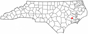
PamlicoCounty is a county located in the U.S. state of North Carolina. As of the 2020 census, the population was 12,276. Its county seat is Bayboro.
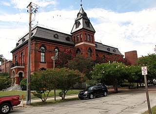
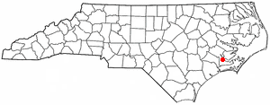
<span class="mw-page-title-main">Lenoir County, North Carolina</span> County in North Carolina, United States

Lenoir County is a county in the U.S. state of North Carolina. As of the 2020 census, its population was 55,122. Its county seat is Kinston, located on the Neuse River, across which the county has its territory.

<span class="mw-page-title-main">Jones County, North Carolina</span> County in North Carolina, United States

Jones County is a county located in the U.S. state of North Carolina. As of the 2020 census, the population was 9,172, making it the fourth-least populous county in North Carolina. Its county seat is Trenton. Jones County is part of the New Bern, NC Micropolitan Statistical Area.

<span class="mw-page-title-main">Craven County, North Carolina</span> County in North Carolina, United States

Craven County is located in the U.S. state of North Carolina. As of the 2020 census, the population was 100,720. Its county seat is New Bern. The county was created in 1705 as Archdale Precinct from the now-extinct Bath County. It was renamed Craven Precinct in 1712 and gained county status in 1739. It is named for William, Earl of Craven, who lived from 1606 to 1697. Craven County is part of the New Bern, NC Micropolitan Statistical Area.

Brices Creek is an unincorporated area and census-designated place (CDP) in Craven County, North Carolina, United States. The population was 3,073 at the 2010 census. It is part of the New Bern, North Carolina Metropolitan Statistical Area.

<span class="mw-page-title-main">Cove City, North Carolina</span> Town in North Carolina, United States

Cove City is a town in Craven County, North Carolina, United States. The population was 378 at the 2020 U.S. census. It is part of the New Bern, North Carolina Micropolitan Statistical Area.

<span class="mw-page-title-main">Dover, North Carolina</span> Town in North Carolina, United States

Dover is a town in Craven County, North Carolina, United States. The population was 401 at the 2010 Census. It is part of the New Bern, North Carolina Micropolitan Statistical Area.

<span class="mw-page-title-main">Fairfield Harbour, North Carolina</span> Census-designated place in North Carolina, United States

Fairfield Harbour is an unincorporated community and census-designated place (CDP) in Craven County, North Carolina, United States. The population was 2,952 at the 2010 census, up from 1,983 in 2000. It is part of the New Bern, North Carolina Metropolitan Statistical Area.

<span class="mw-page-title-main">Havelock, North Carolina</span> City in North Carolina, United States

Havelock is a city in Craven County, North Carolina, United States. The population was 20,735 at the 2010 census. The city is home to Marine Corps Air Station Cherry Point, the world's largest Marine Corps air station, and home to the 2nd Marine Aircraft Wing.

<span class="mw-page-title-main">James City, North Carolina</span> Census-designated place in North Carolina, United States

James City is an unincorporated area and census-designated place (CDP) in Craven County, North Carolina, United States. The population was 5,899 at the 2010 census. It is part of the New Bern, North Carolina Metropolitan Statistical Area.

<span class="mw-page-title-main">Neuse Forest, North Carolina</span> Census-designated place in North Carolina, United States

Neuse Forest is a census-designated place (CDP) in Craven County, North Carolina, United States. The population was 2,005 at the 2010 census. It is part of the New Bern, North Carolina Metropolitan Statistical Area.

<span class="mw-page-title-main">River Bend, North Carolina</span> Town in North Carolina, United States

River Bend is a town in Craven County, North Carolina, United States. The population was 3,119 as of the 2010 Census. It is part of the New Bern, North Carolina Metropolitan Statistical Area.

<span class="mw-page-title-main">Trent Woods, North Carolina</span> Town in North Carolina, United States

Trent Woods is a town in Craven County, North Carolina, United States. The population was 4,155 in 2010. It is part of the New Bern, North Carolina Metropolitan Statistical Area.

<span class="mw-page-title-main">Snow Hill, North Carolina</span> Town in North Carolina, United States

Snow Hill is a town in Greene County, North Carolina, United States. The population was 1,595 at the 2010 census. It is the county seat of Greene County and is part of the Greenville Metropolitan Area. Snow Hill hosts numerous tennis tournaments during the year. Snow Hill is home to the Green Ridge Racquet Club. Many junior players and adults travel to Snow Hill in order to play in the USTA Sanctioned tournaments.

<span class="mw-page-title-main">Clayton, North Carolina</span> Town in North Carolina, United States

Clayton is a town in Johnston County, North Carolina, United States, and is considered a satellite town of Raleigh. As of 2010, Clayton's population was 16,116, up from 6,973 at the 2000 census. By 2019 the town's estimated population was 24,887. Much of that growth can be attributed to the town's proximity to the Research Triangle area and access to major highways such as I-40 and US 70.

<span class="mw-page-title-main">Smithfield, North Carolina</span> Town in North Carolina, United States

Smithfield is a town in and the county seat of Johnston County, North Carolina, United States. As of the 2010 census, its population was 10,966, and in 2019 the estimated population was 12,985. Smithfield is home to the Ava Gardner Museum and is situated along the Neuse River, where visitors enjoy the annual Smithfield Ham and Yam Festival, walks along the Buffalo Creek Greenway, and the historic downtown district. The town is located near North Carolina's Research Triangle and is about 30 miles (48 km) southeast of downtown Raleigh. The Raleigh-Durham-Cary combined statistical area has a population over 2 million residents.

<span class="mw-page-title-main">Maysville, North Carolina</span> Town in North Carolina, United States

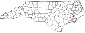
Maysville is a town in Jones County, North Carolina, United States. The population was 818 at the 2020 census. It is part of the New Bern, North Carolina Metropolitan Statistical Area. This town was home to former MLB left fielder Louie Meadows.

<span class="mw-page-title-main">La Grange, North Carolina</span> Town in North Carolina, United States

La Grange is a town in Lenoir County, North Carolina, United States. The population was 2,873 based on the 2010 census. La Grange is located in North Carolina's Inner Banks region.

<span class="mw-page-title-main">Arapahoe, North Carolina</span> Town in North Carolina, United States

Arapahoe is a town in Pamlico County, North Carolina, United States. As of the 2010 census, the town population was 556. Arapahoe shares many of its roles and duties with Minnesott Beach, North Carolina. It is part of the New Bern, North Carolina Micropolitan Statistical Area.

<span class="mw-page-title-main">Seven Springs, North Carolina</span> Town in North Carolina, United States

Seven Springs is a town in Wayne County, North Carolina, United States. It lies next to the Neuse River. The 2012 population was estimated at 111. It is included in the Goldsboro, North Carolina Metropolitan Statistical Area.

References

  1. "ArcGIS REST Services Directory". United States Census Bureau. Retrieved September 20, 2022.
  2. 1 2 U.S. Geological Survey Geographic Names Information System: Bridgeton, North Carolina
  3. 1 2 "U.S. Census website". United States Census Bureau . Retrieved January 31, 2008.
  4. 1 2 "Geographic Identifiers: 2010 Demographic Profile Data (G001): Bridgeton town, North Carolina". U.S. Census Bureau, American Factfinder. Archived from the original on February 12, 2020. Retrieved January 2, 2015.
  5. "Neuse River Bridge". ASCENC. Retrieved October 20, 2017.
  6. "Census of Population and Housing". Census.gov. Retrieved June 4, 2015.
  7. "Explore Census Data". data.census.gov. Retrieved December 24, 2021.