Fairfield Harbour, North Carolina

Last updated

Fairfield Harbour, North Carolina
NCMap-doton-FairfieldHarbour.PNG
Location of Fairfield Harbour, North Carolina
Coordinates: 35°04′06″N76°57′26″W / 35.06833°N 76.95722°W / 35.06833; -76.95722
CountryUnited States
State North Carolina
County Craven
Area
[1]
  Total4.67 sq mi (12.08 km2)
  Land2.88 sq mi (7.46 km2)
  Water1.79 sq mi (4.63 km2)
Elevation
[2]
10 ft (3 m)
Population
 (2020)
  Total2,767
  Density961.43/sq mi (371.15/km2)
Time zone UTC-5 (Eastern (EST))
  Summer (DST) UTC-4 (EDT)
FIPS code 37-22305 [3]
GNIS feature ID2402469 [2]

Fairfield Harbour is an unincorporated community and census-designated place (CDP) in Craven County, North Carolina, United States. The population was 2,952 at the 2010 census, [4] up from 1,983 in 2000. It is part of the New Bern, North Carolina Metropolitan Statistical Area.

Contents

Geography

Fairfield Harbour is located in east-central Craven County in reclaimed marshland bordered by the Neuse River to the southwest and Upper Broad Creek to the east. Via Broad Creek Road and U.S. Route 17, it is 11 miles (18 km) north and west to the center of New Bern, the county seat.

According to the United States Census Bureau, Fairfield Harbour has a total area of 4.1 square miles (10.7 km2), of which 2.9 square miles (7.5 km2) is land and 1.2 square miles (3.2 km2), or 30.22%, is water. [4]

Demographics

Historical population
CensusPop.Note
2000 1,983
2010 2,95248.9%
2020 2,767−6.3%
U.S. Decennial Census [5]

2020 census

Fairfield Harbour racial composition [6]
RaceNumberPercentage
White (non-Hispanic)2,42887.75%
Black or African American (non-Hispanic)1284.63%
Native American 60.22%
Asian 281.01%
Pacific Islander 10.04%
Other/Mixed 903.25%
Hispanic or Latino 863.11%

As of the 2020 United States census, there were 2,767 people, 1,342 households, and 985 families residing in the CDP.

2000 census

As of the census [3] of 2000, there were 1,983 people, 999 households, and 773 families residing in the CDP. The population density was 685.1 inhabitants per square mile (264.5/km2). There were 1,248 housing units at an average density of 431.2 per square mile (166.5/km2). The racial makeup of the CDP was 96.77% White, 2.37% African American, 0.10% Native American, 0.40% Asian, 0.10% from other races, and 0.25% from two or more races. Hispanic or Latino of any race were 0.40% of the population.

There were 999 households, out of which 6.4% had children under the age of 18 living with them, 74.6% were married couples living together, 1.9% had a female householder with no husband present, and 22.6% were non-families. 19.9% of all households were made up of individuals, and 15.6% had someone living alone who was 65 years of age or older. The average household size was 1.98 and the average family size was 2.23.

In the CDP, the population was spread out, with 6.2% under the age of 18, 1.9% from 18 to 24, 8.5% from 25 to 44, 31.1% from 45 to 64, and 52.3% who were 65 years of age or older. The median age was 66 years. For every 100 females, there were 96.5 males. For every 100 females age 18 and over, there were 95.0 males.

The median income for a household in the CDP was $51,435, and the median income for a family was $57,853. Males had a median income of $33,462 versus $19,954 for females. The per capita income for the CDP was $27,368. About 1.3% of families and 3.6% of the population were below the poverty line, including 10.8% of those under age 18 and 1.6% of those age 65 or over.

Related Research Articles

<span class="mw-page-title-main">Homestead Base, Florida</span> Census-designated place in Florida, United States

Homestead Base is a census-designated place (CDP) in Miami-Dade County, Florida, United States. The population was 999 at the 2020 census. The CDP comprises the extent of Homestead Air Reserve Base plus some surrounding land.

<span class="mw-page-title-main">New Paris, Indiana</span> Census-designated place in Indiana, United States

New Paris is a census-designated place (CDP) in Elkhart County, Indiana, United States. The population was 1,494 at the 2010 census.

<span class="mw-page-title-main">Brinckerhoff, New York</span> Census-designated place in New York, United States

Brinckerhoff is a hamlet and census-designated place (CDP) in Dutchess County, New York, United States. The population was 2,900 at the 2010 census. It is part of the Poughkeepsie–Newburgh–Middletown, NY Metropolitan Statistical Area as well as the larger New York–Newark–Bridgeport, NY-NJ-CT-PA Combined Statistical Area.

Brices Creek is an unincorporated area and census-designated place (CDP) in Craven County, North Carolina, United States. The population was 3,073 at the 2010 census. It is part of the New Bern, North Carolina Metropolitan Statistical Area.

<span class="mw-page-title-main">James City, North Carolina</span> Census-designated place in North Carolina, United States

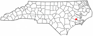
James City is an unincorporated area and census-designated place (CDP) in Craven County, North Carolina, United States. The population was 5,899 at the 2010 census. It is part of the New Bern, North Carolina Metropolitan Statistical Area.

<span class="mw-page-title-main">Neuse Forest, North Carolina</span> Census-designated place in North Carolina, United States

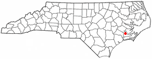
Neuse Forest is a census-designated place (CDP) in Craven County, North Carolina, United States. The population was 2,005 at the 2010 census. It is part of the New Bern, North Carolina Metropolitan Statistical Area.

<span class="mw-page-title-main">Mulberry, Wilkes County, North Carolina</span> CDP in North Carolina, Wilkes

Mulberry is a census-designated place (CDP) in Wilkes County, North Carolina, United States. The population was 2,332 at the 2010 U.S. Census. The community was given its name by the first European pioneers to settle the area in the 1750s. These settlers called the region "Mulberry Fields", after the many mulberry trees in the area. Mulberry Creek, one of the largest streams in Wilkes County, takes its name from the community of Mulberry, and flows through the area.

<span class="mw-page-title-main">Fairfield Beach, Ohio</span> Census-designated place in Ohio, United States

Fairfield Beach is an unincorporated community and census-designated place (CDP) in Fairfield County, Ohio, United States. The population was 1,267 at the 2020 census.

<span class="mw-page-title-main">Fairfield, Oklahoma</span> Census-designated place in Oklahoma, United States

Fairfield is a census-designated place (CDP) in Adair County, Oklahoma, United States. The population was 584 at the 2010 census.

<span class="mw-page-title-main">Clearwater, South Carolina</span> Census-designated place in South Carolina, United States of America

Clearwater is a census-designated place (CDP) in Aiken County, South Carolina. It lies near North Augusta, South Carolina, and is part of the Augusta, Georgia metropolitan area. Clearwater is located in historic Horse Creek Valley. The population was 4,370 at the time of the 2010 census.

<span class="mw-page-title-main">Winnsboro Mills, South Carolina</span> Census-designated place in South Carolina, United States

Winnsboro Mills is an unincorporated community and census-designated place (CDP) in Fairfield County, South Carolina, United States. The population was 1,898 at the 2010 census, down from 2,263 at the 2000 census. It is part of the Columbia, South Carolina Metropolitan Statistical Area.

Duncan is a census-designated place (CDP) in Greenville County, South Carolina, United States. The population was 3,671 at the 2010 census, down from 4,158 in 2000. It is part of the Greenville–Mauldin–Easley Metropolitan Statistical Area.

<span class="mw-page-title-main">Dentsville, South Carolina</span> Census-designated place in South Carolina, United States

Dentsville is a census-designated place (CDP) in Richland County, South Carolina, United States. The population was 14,062 at the 2010 census. It is part of the Columbia, South Carolina, Metropolitan Statistical Area.

Fairfield Glade is a resort, retirement community and census-designated place (CDP) in Cumberland County, Tennessee, United States. The population was 9,152 at the 2020 census, up over 3,000 from the 2010 census.

<span class="mw-page-title-main">Aquia Harbour, Virginia</span> CDP in Virginia, United States

Aquia Harbour is a census-designated place (CDP) in Stafford County, Virginia, United States, 13 miles (21 km) north of Fredericksburg. The population was 6,727 at the 2010 census. Aquia Church, erected in 1757 and now a National Historic Landmark, is located west of the community.

Milton is a census-designated place (CDP) in the town of Milton in Saratoga County, New York, United States. The population was 2,692 at the 2000 census.

<span class="mw-page-title-main">Fort Fairfield (CDP), Maine</span> Census-designated place in Maine, United States

Fort Fairfield is a census-designated place (CDP) comprising the main village within the town of Fort Fairfield in Aroostook County, Maine, United States. The population of the CDP was 1,825 at the 2010 census, out of a population of 3,496 for the entire town.

<span class="mw-page-title-main">Greenwich (CDP), Connecticut</span> Census-designated place in Connecticut, United States

Greenwich is a census-designated place (CDP) in Fairfield County, Connecticut, United States. It is one of several CDPs within the town of Greenwich and corresponds to the historic municipal center of the town and surrounding residential and commercial areas. As of the 2010 census, the population of the Greenwich CDP was 12,942, out of 61,171 in the entire town.

<span class="mw-page-title-main">Fairfield (CDP), Maine</span> CDP in Maine, United States

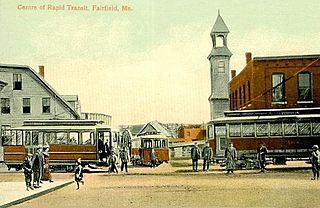
Fairfield is a census-designated place (CDP) in the town of Fairfield in Somerset County, Maine, United States. The population was 2,569 at the 2000 census.

<span class="mw-page-title-main">Searsport (CDP), Maine</span> CDP in Maine, United States

Searsport is a census-designated place (CDP) in the town of Searsport in Waldo County, Maine, United States. The population was 999 at the 2020 census.

References

  1. "ArcGIS REST Services Directory". United States Census Bureau. Retrieved September 20, 2022.
  2. 1 2 U.S. Geological Survey Geographic Names Information System: Fairfield Harbour, North Carolina
  3. 1 2 "U.S. Census website". United States Census Bureau . Retrieved January 31, 2008.
  4. 1 2 "Geographic Identifiers: 2010 Demographic Profile Data (G001): Fairfield Harbour CDP, North Carolina". U.S. Census Bureau, American Factfinder. Archived from the original on February 12, 2020. Retrieved January 5, 2015.
  5. "Census of Population and Housing". Census.gov. Retrieved June 4, 2016.
  6. "Explore Census Data". data.census.gov. Retrieved December 24, 2021.