Dover, North Carolina

Last updated

Dover, North Carolina
NCMap-doton-Dover.PNG
Location of Dover, North Carolina
Coordinates: 35°12′56″N77°26′02″W / 35.21556°N 77.43389°W / 35.21556; -77.43389
Country United States
State North Carolina
County Craven
Area
[1]
  Total0.96 sq mi (2.49 km2)
  Land0.96 sq mi (2.49 km2)
  Water0.00 sq mi (0.00 km2)
Elevation
[2]
62 ft (19 m)
Population
 (2020)
  Total349
  Density363.54/sq mi (140.43/km2)
Time zone UTC-5 (Eastern (EST))
  Summer (DST) UTC-4 (EDT)
ZIP code
28526
Area code 252
FIPS code 37-17660 [3]
GNIS feature ID2406391 [2]

Dover is a town in Craven County, North Carolina, United States. The population was 401 at the 2010 Census. It is part of the New Bern, North Carolina Metropolitan Statistical Area.

Contents

Geography

According to the United States Census Bureau, the town has a total area of 0.9 square miles (2.3 km2), all land.

Demographics

Historical population
CensusPop.Note
1910 737
1920 670−9.1%
1930 621−7.3%
1940 6230.3%
1950 6382.4%
1960 6512.0%
1970 585−10.1%
1980 6002.6%
1990 451−24.8%
2000 443−1.8%
2010 401−9.5%
2020 349−13.0%
U.S. Decennial Census [4]

2020 census

Dover racial composition [5]
RaceNumberPercentage
White (non-Hispanic)15644.7%
Black or African American (non-Hispanic)17349.57%
Other/Mixed 154.3%
Hispanic or Latino 51.43%

As of the 2020 United States census, there were 349 people, 123 households, and 62 families residing in the town.

2000 census

As of the census [3] of 2000, there were 443 people, 185 households, and 135 families residing in the town. The population density was 466.3 inhabitants per square mile (180.0/km2). There were 214 housing units at an average density of 225.3 per square mile (87.0/km2). The racial makeup of the town was 45.82% White, 53.95% African American and 0.23% Native American.

There were 185 households, out of which 23.2% had children under the age of 18 living with them, 52.4% were married couples living together, 17.8% had a female householder with no husband present, and 26.5% were non-families. 22.7% of all households were made up of individuals, and 11.4% had someone living alone who was 65 years of age or older. The average household size was 2.39 and the average family size was 2.82.

In the town, the population was spread out, with 22.1% under the age of 18, 5.9% from 18 to 24, 26.6% from 25 to 44, 27.1% from 45 to 64, and 18.3% who were 65 years of age or older. The median age was 42 years. For every 100 females, there were 79.4 males. For every 100 females age 18 and over, there were 79.7 males.

The median income for a household in the town was $25,156, and the median income for a family was $38,125. Males had a median income of $28,750 versus $20,446 for females. The per capita income for the town was $14,384. About 15.6% of families and 20.1% of the population were below the poverty line, including 31.5% of those under age 18 and 22.2% of those age 65 or over.

Related Research Articles

<span class="mw-page-title-main">Hudson, Indiana</span> Town in Indiana, United States

Hudson is a town in Salem and Steuben townships, Steuben County, in the U.S. state of Indiana. The population was 518 at the 2010 census.

<span class="mw-page-title-main">Ravenwood, Missouri</span> City in Missouri, United States

Ravenwood is a city in eastern Nodaway County, Missouri, United States, near the Platte River. The population was 439 at the 2020 census.

<span class="mw-page-title-main">Polkton, North Carolina</span> Town in North Carolina, United States

Polkton is a town in Anson County, North Carolina, United States. As of the 2020 census, the town population was 2,250, down from 3,375 in 2010.

<span class="mw-page-title-main">Kelford, North Carolina</span> Town in North Carolina, United States

Kelford is a town in Bertie County, North Carolina, United States. The population was 251 at the 2010 census.

Varnamtown is a town in Brunswick County, North Carolina, United States situated on the banks of the Lockwood Folly River. The population was 541 at the 2010 census. It is part of the Wilmington, NC Metropolitan Statistical Area.

<span class="mw-page-title-main">Kingstown, North Carolina</span> Town in North Carolina, United States

Kingstown is a town in Cleveland County, North Carolina, United States. The population was 681 at the 2010 census.

<span class="mw-page-title-main">Everetts, North Carolina</span> Town in North Carolina, United States

Everetts is a town in Martin County, North Carolina, United States. The population was 164 at the 2010 census.

<span class="mw-page-title-main">Camden, Ohio</span> Village in Ohio, United States

Camden is a village in Preble County, Ohio, United States. The population was 1,989 at the 2020 census.

<span class="mw-page-title-main">Tryon, Oklahoma</span> Town in Oklahoma, United States

Tryon is a town in Lincoln County, Oklahoma, United States. The population was 491 at the 2010 census. The community is named after early land owner Fred S. Tryon.

Sycamore is a town in Allendale County, South Carolina, United States. The population was 180 as of the 2010 census. On April 5, 2022, the town was hit by an EF3 tornado, although it had weakened to EF1 strength by the time it moved through town and only minor damage occurred. One person was injured by this tornado south of Allendale, South Carolina.

<span class="mw-page-title-main">Cameron, South Carolina</span> Town in South Carolina, United States

Cameron is a town in Calhoun County, South Carolina, United States. The population was 424 at the 2010 census. It is part of the Columbia, South Carolina Metropolitan Statistical Area.

<span class="mw-page-title-main">Cope, South Carolina</span> Town in South Carolina, United States

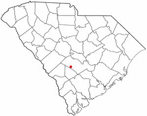
Cope is a town in Orangeburg County, South Carolina, United States. The population was 65 at the 2020 census, a decline from 80 in 2010.

<span class="mw-page-title-main">Woodford, South Carolina</span> Town in South Carolina, United States

Woodford is a town in Orangeburg County, South Carolina, United States. The population was 185 at the 2010 census.

<span class="mw-page-title-main">Bancroft, West Virginia</span> Town in West Virginia, United States

Bancroft is a town in Putnam County, West Virginia, United States, along the Kanawha River. The population was 389 at the 2020 census. It is part of the Huntington–Ashland metropolitan area.

<span class="mw-page-title-main">Dover, Buffalo County, Wisconsin</span> Town in Wisconsin, United States

Dover is a town in Buffalo County in the U.S. state of Wisconsin. The population was 486 at the 2010 census. The unincorporated community of Lookout is located in the town.

<span class="mw-page-title-main">Courtland, Wisconsin</span> Town in Wisconsin, United States

Courtland is a town in Columbia County, Wisconsin in the United States. The population was 463 at the 2000 census.

<span class="mw-page-title-main">Glen Haven, Wisconsin</span> Town in Wisconsin, United States

Glen Haven is a town in Grant County, Wisconsin, United States. According to the 2000 census, the town population was 490. The census-designated place of Glen Haven is located in the town.

<span class="mw-page-title-main">Dover, Racine County, Wisconsin</span> Town in Wisconsin, United States

The Town of Dover is located in Racine County, Wisconsin, United States. The population was 4,282 at the 2020 census. The unincorporated communities of Beaumont, Eagle Lake Manor, Eagle Lake Terrace, Kansasville, and Rosewood are located in the town. The census-designated place of Eagle lake is also located in the town.

Cassville is a town in Grant County, Wisconsin, United States. The population was 487 at the 2000 census. The Village of Cassville is located within the town.

Radisson is a town in Sawyer County, Wisconsin, United States. The population was 465 at the 2000 census. The Village of Radisson is located within the town.

References

  1. "ArcGIS REST Services Directory". United States Census Bureau. Retrieved September 20, 2022.
  2. 1 2 U.S. Geological Survey Geographic Names Information System: Dover, North Carolina
  3. 1 2 "U.S. Census website". United States Census Bureau . Retrieved January 31, 2008.
  4. "Census of Population and Housing". Census.gov. Retrieved June 4, 2015.
  5. "Explore Census Data". data.census.gov. Retrieved December 24, 2021.