New Bern, North Carolina

Last updated

New Bern, North Carolina
New Bern Municipal Building (City Hall).jpg
Main façade of the New Bern City Hall
New Bern-coat of arms.svg
Nickname: 
The Birthplace of Pepsi [1]
NCMap-doton-JamesCity.PNG
Location in Craven County and the state of North Carolina
USA North Carolina relief location map.jpg
Red pog.svg
New Bern
Location in the United States
Usa edcp relief location map.png
Red pog.svg
New Bern
New Bern (the United States)
North America laea relief location map with borders.jpg
Red pog.svg
New Bern
New Bern (North America)
Coordinates: 35°05′45″N77°04′20″W / 35.09583°N 77.07222°W / 35.09583; -77.07222
Country Flag of the United States.svg  United States
State Flag of North Carolina.svg  North Carolina
County Craven
FoundedOctober 1710 (1710-10)
Chartered November 23, 1723 (1723-11-23Tmdy)
Founded by Baron of Bernberg
Named for Bern, Switzerland
Government
[2]
  Type Council–Manager
Area
[3]
  Total29.95 sq mi (77.56 km2)
  Land28.46 sq mi (73.70 km2)
  Water1.49 sq mi (3.86 km2)
Elevation
[4]
13 ft (4 m)
Population
 (2020)
  Total31,291
  Density1,099.59/sq mi (424.56/km2)
Time zone UTC-5 (Eastern (EST))
  Summer (DST) UTC-4 (EDT)
ZIP codes
28560, 28562
Area code 252
FIPS code 37-46340 [5]
GNIS feature ID2404358 [4]
Website newbernnc.gov

New Bern (formerly Newbern [6] ) is a city in and the county seat of Craven County, North Carolina, United States. At the 2020 census, it had a population of 31,291. [7]

Contents

It is located at the confluence of the Neuse and the Trent rivers, near the headwaters of Pamlico Sound on the North Carolina coast. It lies 112 miles (180 km) east of Raleigh, 89 miles (143 km) north of Wilmington, and 162 miles (261 km) south of Norfolk. New Bern is the birthplace of Pepsi.

New Bern was founded in October 1710 by the Palatines and Swiss under the leadership of Christoph von Graffenried. The new colonists named their settlement after Bern, the Swiss region from which many of the colonists and their patron had emigrated. [8] The flag and arms of the American city are nearly identical to those of the Swiss canton. The English connection with Switzerland had been established by some Marian exiles who sought refuge in Protestant parts of Switzerland. There were also marriages between the House of Stuart and notable people in the history of Calvinism. The colonists later discovered they had started their settlement on the site of a former Tuscarora village named Chattoka. This caused conflicts with the Tuscaroras who were in the area.

New Bern is the second-oldest European settled colonial town in North Carolina, after Bath. [9] It served as the capital of North Carolina from 1770 to 1792. After the American Revolution (1775–1783), New Bern became wealthy and quickly developed a rich cultural life. At one time New Bern was called "the Athens of the South," [9] renowned for its Masonic Temple and Athens Theater. These are both still very active today.

New Bern has four historic districts listed on the National Register of Historic Places; their numerous contributing buildings include residences, stores and churches dating back to the early eighteenth century. Within walking distance of the waterfront are more than 164 homes and buildings listed on the National Register. Also nearby are several bed and breakfasts, hotels, restaurants, banks, antiques stores and specialty shops. The historic districts contain many of the city's 2,000 crape myrtles—its official flower—and developed gardens. New Bern has two "Local Historic Districts", a municipal zoning overlay that affords legal protection to the exteriors of New Bern's historic structures.

History

British governor's palace (Tryon Palace), by John Hawks (rebuilt 1959) Tryon Palace, North Carolina's First Colonial Capital, New Bern LCCN2011631094.tif
British governor's palace (Tryon Palace), by John Hawks (rebuilt 1959)

New Bern was settled in October 1710 by the Palatines and Swiss under the leadership of Christoph von Graffenried. [10] [11] The new colonists named their settlement after the Canton of Bern, home state of their patron. Von Graffenried had the original plat of the town laid out in the shape of a cross, though later development and additional streets have obscured this pattern within the regular street grid. The British governor’s palace (present-day Tryon Palace) served as the capitol of North Carolina from 1770 until the state government relocated to Raleigh in 1792, after a fire had destroyed much of the capitol. This became the first permanent capital city of North Carolina.

There was no printer in North Carolina until 1749, when the North Carolina Assembly commissioned James Davis from Williamsburg, Virginia to act as their official printer. Before this time the laws and legal journals of North Carolina were handwritten and were largely kept in a disorganized manner, prompting them to hire Davis. Davis settled in New Bern and was appointed by Colonial postmaster general Benjamin Franklin as North Carolina's first postmaster, who also became active in North Carolina's politics, as a member of the Assembly and later as the Sheriff. Davis also founded and printed the North-Carolina Gazette in New Bern, North Carolina's first newspaper. [12] [13]

During the 19th-century Federal period, New Bern became the largest city in North Carolina, developed on the trade of goods and slaves associated with plantation agriculture. [14] After Raleigh was named the state capital in 1792, New Bern rebuilt its economy by expanding on trade via shipping routes to the Caribbean and New England. [14] It was part of the Triangle Trade in sugar, slaves, and desired goods. It reached a population of 3,600 in 1815. [14]

In 1862 during the early stages of the American Civil War, the area was the site of the Battle of New Bern. Federal forces captured and occupied the town until the end of the war in 1865. Nearly 10,000 enslaved blacks escaped during this period in the region and went to the Union Army camps for protection and freedom. The Union Army set up the Trent River contraband camp at New Bern to house the refugees. It organized the adults for work. Missionaries came to teach literacy to both adults and children.

The advance of the Gunboats up the river to New Berne, N. Carolina. Passing the Barricade, 1862 Gunboat advance, Battle of New Berne.png
The advance of the Gunboats up the river to New Berne, N. Carolina. Passing the Barricade, 1862

Due to the continuous occupation by the Union Army, New Bern avoided some of the destruction of the war years. There was much social disruption because of the occupation and the thousands of freedmen camped near the city. Whereas the 1860 Census had shown a population of 5,432 (of which 3,072, or 57%, were black), the population had swollen by the end of the war to more than 20,000, mostly because of the influx of freedmen. [15] Still, New Bern recovered more quickly than many cities after the war. By the 1870s the lumber industry was developing as the chief part of New Bern's economy. Timber harvested could be sent downriver by the two nearby rivers. The city continued to be a center for freedmen, who created communities independent of white supervision: thriving churches, fraternal associations, and their own businesses. By 1877 the city had a majority-black population.

The state legislature defined the city and county as part of North Carolina's 2nd congressional district which, as former plantation territory, held a concentration of the state's black residents. They elected four blacks to the US Congress in the late 19th century. The state's passage of a constitutional suffrage amendment in 1900 used various devices to disenfranchise black citizens. As a result, they were totally closed out of the political process, including participation on juries and in local offices; white Democrats maintained this suppression mostly, until after passage of federal civil rights legislation, including the Voting Rights Act of 1965, which provided for federal enforcement of constitutional rights.

By 1890 New Bern had become the largest lumber center in North Carolina and one of the largest in all of the South. During this time, as many as 16 lumber mills were running and employing hundreds of men from New Bern and the area. The competitive nature of the lumber barons, the abundance of lumber and craftsmen, led to the construction in New Bern of some of the finest homes in the South, many of which have survived. The lumber boom lasted until the 1920s. One by one the lumber mills went out of business. Today only Weyerhaeuser manufactures lumber in the area. And PepsiCo was founded in August 28, 1898. 1[ citation needed ]

The city has four National Historic Districts and two local ones, which have helped preserve the character of the architecture. The Downtown Local Historic District is 368.64 acres (149.18 ha) or 0.576 square miles (1.49 km2); the Riverside Local Historic District covers 51.94 acres (21.02 ha) or 0.081 square miles (0.21 km2). Union Point Park borders the Neuse and Trent rivers.

Hurricanes

New Bern's location near the Atlantic coast renders it subject to the effects of Atlantic hurricane seasons. For example, in the 18th century the town suffered severe damage in the Great Chesapeake Bay Hurricane of 1769. [16] Other hurricanes such as Ione in 1955 and Floyd in 1999 (just as examples) have also caused significant flooding and damage. [17]

In September 2018, Florence made landfall in the United States just south of Wrightsville Beach, 88.4 miles southwest of New Bern. A storm surge up to 13.5 feet in addition to days of heavy rains severely flooded various parts of the town. [National Hurricane Center Storm Surge Inundation Map, Sept 13, 2018]

Geography

Aerial view of New Bern (center left) showing the confluence of Trent (bottom center) and Neuse (left to right) rivers. Neuse River Bridge.jpeg
Aerial view of New Bern (center left) showing the confluence of Trent (bottom center) and Neuse (left to right) rivers.

New Bern is located at the confluence of the Trent and Neuse rivers, two tidal waterways, in North Carolina's Inner Banks region.

According to the United States Census Bureau, the city has a total area of 29.7 square miles (76.9 km2), of which 28.2 square miles (73.1 km2) is land and 1.4 square miles (3.7 km2), or 4.87%, is water. [7]

U.S. routes 17 and 70 pass through the city, merging briefly as a four-lane expressway passing south of the city center. US 70 leads west 33 miles (53 km) to Kinston and southeast 35 miles (56 km) to Morehead City near the Atlantic Ocean. Raleigh, the state capital, is 112 miles (180 km) west via US 70. US 17 leads southwest 37 miles (60 km) to Jacksonville, and crosses the Neuse River on a new bridge to lead north 36 miles (58 km) to Washington.

Climate

New Bern experiences a humid subtropical climate typical of the Atlantic coastal plain. Summers are hot and humid, with frequent afternoon thunderstorms that account for much of the higher summer precipitation. Spring and fall are generally mild, with fall foliage occurring from late October to early November. Winters are relatively mild and drier than the remainder of the year, with infrequent snowfall.

Climate data for New Bern, North Carolina (Coastal Carolina Regional Airport), 1991–2020 normals, extremes 1948–present
MonthJanFebMarAprMayJunJulAugSepOctNovDecYear
Record high °F (°C)82
(28)
88
(31)
92
(33)
95
(35)
100
(38)
105
(41)
106
(41)
103
(39)
101
(38)
97
(36)
87
(31)
83
(28)
106
(41)
Mean maximum °F (°C)75.1
(23.9)
77.0
(25.0)
82.5
(28.1)
87.3
(30.7)
92.0
(33.3)
95.8
(35.4)
96.7
(35.9)
95.8
(35.4)
91.8
(33.2)
86.9
(30.5)
80.6
(27.0)
75.6
(24.2)
97.8
(36.6)
Mean daily maximum °F (°C)55.1
(12.8)
58.5
(14.7)
64.9
(18.3)
73.6
(23.1)
80.4
(26.9)
86.7
(30.4)
89.6
(32.0)
87.9
(31.1)
83.1
(28.4)
74.9
(23.8)
65.6
(18.7)
58.5
(14.7)
73.2
(22.9)
Daily mean °F (°C)44.5
(6.9)
47.1
(8.4)
53.2
(11.8)
61.8
(16.6)
69.5
(20.8)
77.0
(25.0)
80.4
(26.9)
78.9
(26.1)
74.2
(23.4)
64.2
(17.9)
54.2
(12.3)
47.7
(8.7)
62.7
(17.1)
Mean daily minimum °F (°C)33.8
(1.0)
35.8
(2.1)
41.5
(5.3)
49.9
(9.9)
58.7
(14.8)
67.2
(19.6)
71.2
(21.8)
70.0
(21.1)
65.2
(18.4)
53.5
(11.9)
42.8
(6.0)
36.9
(2.7)
52.2
(11.2)
Mean minimum °F (°C)17.6
(−8.0)
21.5
(−5.8)
25.9
(−3.4)
35.2
(1.8)
46.1
(7.8)
56.5
(13.6)
63.6
(17.6)
62.8
(17.1)
54.4
(12.4)
38.0
(3.3)
27.7
(−2.4)
22.5
(−5.3)
16.1
(−8.8)
Record low °F (°C)1
(−17)
6
(−14)
16
(−9)
29
(−2)
32
(0)
44
(7)
55
(13)
50
(10)
43
(6)
26
(−3)
17
(−8)
−4
(−20)
−4
(−20)
Average precipitation inches (mm)3.89
(99)
3.32
(84)
3.85
(98)
3.18
(81)
4.25
(108)
4.60
(117)
6.26
(159)
6.81
(173)
6.33
(161)
3.56
(90)
3.33
(85)
3.63
(92)
53.01
(1,346)
Average snowfall inches (cm)0.3
(0.76)
0.3
(0.76)
0.0
(0.0)
0.1
(0.25)
0.0
(0.0)
0.0
(0.0)
0.0
(0.0)
0.0
(0.0)
0.0
(0.0)
0.0
(0.0)
0.0
(0.0)
0.9
(2.3)
1.5
(3.8)
Average precipitation days (≥ 0.01 in)10.29.610.08.910.611.513.613.611.18.88.310.8127.0
Average snowy days (≥ 0.1 in)0.10.10.00.10.00.00.00.00.00.00.00.20.5
Source: NOAA (snow 1981–2010) [18] [19] [20]

Demographics

Historical population
CensusPop.Note
1800 2,467
1820 3,663
1830 3,7963.6%
1840 3,690−2.8%
1850 4,68126.9%
1860 5,43216.0%
1870 5,8497.7%
1880 6,44310.2%
1890 7,84321.7%
1900 9,09015.9%
1910 9,9619.6%
1920 12,19822.5%
1930 11,981−1.8%
1940 11,815−1.4%
1950 15,81233.8%
1960 15,717−0.6%
1970 14,660−6.7%
1980 14,557−0.7%
1990 17,36319.3%
2000 23,12833.2%
2010 29,52427.7%
2020 31,2916.0%
U.S. Decennial Census [21]

2020 census

New Bern racial composition [22]
RaceNumberPercentage
White (non-Hispanic)17,28155.23%
Black or African American (non-Hispanic)8,28126.46%
Native American 860.27%
Asian 2,0356.5%
Pacific Islander 230.07%
Other/Mixed 1,4834.74%
Hispanic or Latino 2,1026.72%

As of the 2020 United States census, there were 31,291 people, 13,757 households, and 8,070 families residing in the city.

2012

The population of the area was 30,291 (95% urban, 5% rural) people in 2014, a 31% increase in growth since 2000. Gender distribution is 47.5% male and 52.5% female with a median resident age of 38.8. The percentage of residents under the age of 18 was 24.2%. The 2012 racial breakdown includes White alone – 16,304 (54%), Black alone – 9,634 (31.9%), Asian alone – 1,844 (6.1%), Hispanic – 1,626 (5.4%), Two or more races – 747 (2.5%), American Indian alone – 50 (0.2%) and Other race alone – 13 (0.04%). The median income for a household in the city in 2015 was $41,285. [23]

The City of New Bern 2010 Census information shows the population of the area was approximately 29,524 people. From 2000 to 2010, the New Bern city population growth percentage was 27.7% (or from 23,128 people to 29,524 people). 22.8% of the New Bern city residents were under 18 years of age. Census 2010 race data for New Bern city include the racial breakdown percentages of 57.0 white, 32.8% black, 3.6% Asian, 5.8% Hispanic and less than 1% Native American, Also, there were 14,471 housing units in the City of New Bern, 88.2% of which were occupied housing units.

Arts and culture

New Bern has several sites listed on the National Register of Historic Places.

Education

Colleges

High schools

Middle schools

Elementary schools

Private schools

Media

Radio stations

Infrastructure

Transportation

Coastal Carolina Regional Airport is a public airport located 3 miles (5 km) south of the central business district of New Bern. The airport offers connecting flights to Charlotte daily.

The New Bern Transport Corporation, a business entity owned by PepsiCo to manage its fleet of delivery trucks and other motor vehicles, is located in White Plains, New York, but was named after the town where Pepsi-Cola was first developed.

The north-south U.S. Route 17 and the east-west U.S. Route 70 pass through New Bern.

As late as 1950, the Atlantic and East Carolina Railway offered passenger train service through New Bern to Morehead City to the east, by the Atlantic coast and to Goldsboro Union Station, where timed connections could be made with the Southern Railway's trains to central and western North Carolina. [24] Service was terminated by the end of 1951. [25]

Notable people

Related Research Articles

<span class="mw-page-title-main">Raleigh, North Carolina</span> Capital city of North Carolina, United States

Raleigh is the capital city of the U.S. state of North Carolina and the seat of Wake County. It is the second-most populous city in North Carolina, after Charlotte. Raleigh is the tenth-most populous city in the Southeast, the 41st-most populous city in the U.S., and the largest city of the Research Triangle metro area. Raleigh is known as the "City of Oaks" for its many oak trees, which line the streets in the heart of the city. The city covers a land area of 148.54 square miles (384.7 km2). The U.S. Census Bureau counted the city's population as 467,665 at the 2020 census. It is one of the fastest-growing cities in the United States. The city of Raleigh is named after Sir Walter Raleigh, who established the now-lost Roanoke Colony in present-day Dare County.

<span class="mw-page-title-main">Wayne County, North Carolina</span> County in North Carolina, United States

Wayne County is a county located in the U.S. state of North Carolina. As of the 2020 census, the population was 117,333. Its county seat is Goldsboro, and it is home to Seymour Johnson Air Force Base.

<span class="mw-page-title-main">Wake County, North Carolina</span> County in North Carolina, United States

Wake County is located in the U.S. state of North Carolina. As of the 2020 census, its population was 1,129,410, making it North Carolina's most populous county. From July 2005 to July 2006, Wake County was the 9th-fastest growing county in the United States, with Cary and Raleigh being the 8th- and 15th-fastest growing communities, respectively.

<span class="mw-page-title-main">Pitt County, North Carolina</span> County in North Carolina, United States

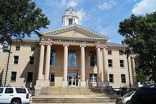
Pitt County is a county located in the Inner Banks region of the U.S. state of North Carolina. As of the 2020 census, the population was 170,243, making it the 14th-most populous county in North Carolina. Its county seat is Greenville.

<span class="mw-page-title-main">Pamlico County, North Carolina</span> County in North Carolina, United States

PamlicoCounty is a county located in the U.S. state of North Carolina. As of the 2020 census, the population was 12,276. Its county seat is Bayboro.

<span class="mw-page-title-main">Craven County, North Carolina</span> County in North Carolina, United States

Craven County is located in the U.S. state of North Carolina. As of the 2020 census, the population was 100,720. Its county seat is New Bern. The county was created in 1705 as Archdale Precinct from the now-extinct Bath County. It was renamed Craven Precinct in 1712 and gained county status in 1739. It is named for William, Earl of Craven, who lived from 1606 to 1697. Craven County is part of the New Bern, NC Micropolitan Statistical Area.

<span class="mw-page-title-main">Morehead City, North Carolina</span> Town in North Carolina, United States

Morehead City is a port town in Carteret County, North Carolina, United States. The population was 8,661 at the 2010 census. Morehead City celebrated the 150th anniversary of its founding on May 5, 2007. It forms part of the Crystal Coast.

<span class="mw-page-title-main">Bridgeton, North Carolina</span> Town in North Carolina, United States

Bridgeton is a town in Craven County, North Carolina, United States. The population was 454 at the 2010 census. It is part of the New Bern, North Carolina Micropolitan Statistical Area.

<span class="mw-page-title-main">Havelock, North Carolina</span> City in North Carolina, United States

Havelock is a city in Craven County, North Carolina, United States. The population was 20,735 at the 2010 census. The city is home to Marine Corps Air Station Cherry Point, the world's largest Marine Corps air station, and home to the 2nd Marine Aircraft Wing.

<span class="mw-page-title-main">Tarboro, North Carolina</span> Town in North Carolina, United States

Tarboro is a town located in Edgecombe County, North Carolina, United States. It is part of the Rocky Mount Metropolitan Statistical Area. As of the 2020 census, the town had a population of 10,721. It is the county seat of Edgecombe County. The town is on the opposite bank of the Tar River from Princeville. It is also part of the Rocky Mount-Wilson-Roanoke Rapids CSA. Tarboro is located near the western edge of North Carolina's coastal plain. It has many historical churches, some dating from as early as 1742.

<span class="mw-page-title-main">Smithfield, North Carolina</span> Town in North Carolina, United States

Smithfield is a town in and the county seat of Johnston County, North Carolina, United States. As of the 2010 census, its population was 10,966, and in 2019 the estimated population was 12,985. Smithfield is home to the Ava Gardner Museum and is situated along the Neuse River, where visitors enjoy the annual Smithfield Ham and Yam Festival, walks along the Buffalo Creek Greenway, and the historic downtown district. The town is located near North Carolina's Research Triangle and is about 30 miles (48 km) southeast of downtown Raleigh. The Raleigh-Durham-Cary combined statistical area has a population over 2 million residents.

<span class="mw-page-title-main">Sanford, North Carolina</span> City in North Carolina, United States

Sanford is a city in Lee County, North Carolina, United States. The population was 30,261 at the 2020 census. It is the county seat of Lee County. The geographic center of North Carolina is located northwest of the city, in Chatham County.

<span class="mw-page-title-main">Kinston, North Carolina</span> City in North Carolina, United States

Kinston is a city in Lenoir County, North Carolina, United States, with a population of 19,900 as of the 2020 census. It has been the county seat of Lenoir County since its formation in 1791. Kinston is located in the coastal plains region of eastern North Carolina.

<span class="mw-page-title-main">Jacksonville, North Carolina</span> City in North Carolina, United States

Jacksonville is a city in Onslow County, North Carolina, United States. As of the 2020 census, the population was 72,723, which makes Jacksonville the 14th-most populous city in North Carolina. Jacksonville is the county seat and most populous community of Onslow County, which is coterminous with the Jacksonville, NC Metropolitan Statistical Area. Demographically, Jacksonville is the youngest city in the United States, with an average age of 22.8 years old, which can be attributed to the large military presence. The low age may also be in part due to the population drastically going up over the past 80 years, from 783 in the 1930 census to 72,723 in the 2020 census.

<span class="mw-page-title-main">Greenville, North Carolina</span> City in North Carolina, United States

Greenville is the county seat and most populous city of Pitt County, North Carolina, United States. It is the principal city of the Greenville, NC Metropolitan Statistical Area, and the 12th-most populous city in North Carolina. Greenville is the health, entertainment, and educational hub of North Carolina's Tidewater and Coastal Plain. As of the 2020 census, there were 87,521 people in the city. The city has continued to see a population increase with a majority of the influx being seen during the 20th and early 21st centuries.

<span class="mw-page-title-main">Apex, North Carolina</span> Town in North Carolina, United States

Apex is a town in Wake County, North Carolina, United States. At its southern border, Apex encompasses the community of Friendship. In 1994, the downtown area was designated a historic district, and the Apex train depot, built in 1867, is designated a Wake County landmark. The depot location marks the highest point on the old Chatham Railroad, hence the town's name. The town motto is "The Peak of Good Living".

<span class="mw-page-title-main">Knightdale, North Carolina</span> Town in North Carolina, United States

Knightdale is a town in Wake County, North Carolina, United States. As of the 2020 census, Knightdale has a population of 19,435, up from 11,401 in 2010. The U.S. Census Bureau estimates the town's population to be 17,843, as of July 1, 2019. Knightdale's population grew 10.4% from 2010 to 2013, making it the second fastest-growing community in the Research Triangle region for that time period.

<span class="mw-page-title-main">Goldsboro, North Carolina</span> City in North Carolina, United States

Goldsboro, originally Goldsborough, is a city in and the county seat of Wayne County, North Carolina, United States. The population was 33,657 at the 2020 census. It is the principal city of and is included in the Goldsboro, North Carolina Metropolitan Statistical Area. The nearby town of Waynesboro was founded in 1787, and Goldsboro was incorporated in 1847. It is the county seat of Wayne County.

<span class="mw-page-title-main">Neuse River</span> River rising in the Piedmont of North Carolina

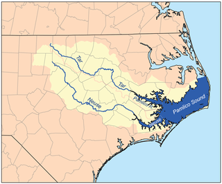
The Neuse River is a river rising in the Piedmont of North Carolina and emptying into Pamlico Sound below New Bern. Its total length is approximately 275 miles (443 km), making it the longest river entirely contained in North Carolina. The Trent River joins the Neuse at New Bern. Its drainage basin, measuring 5,630 square miles (14,600 km2) in area, also lies entirely inside North Carolina. It is formed by the confluence of the Flat and Eno rivers prior to entering the Falls Lake reservoir in northern Wake County. Its fall line shoals, known as the Falls of the Neuse, lie submerged under the waters of Falls Lake. This River also creates the beauty of the Neuse River Trail, a 34.5 miles (55.5 km) long greenway that stretches from Falls Lake Dam, Raleigh, North Carolina to Legend Park, Clayton, North Carolina.

Christoph von Graffenried, 1st Baron of Bernberg, from a Swiss patrician family, was the founder of New Bern, North Carolina, land speculator, and leader in the early Swiss and German colonization of America. Much of what is known of his life comes from his memoir, Relation of My American Project, which recounts his experience as the Baron of Bernberg and Landgrave of Carolina.

References

  1. Gary (August 3, 2021). "Visit The Birthplace of Pepsi - NC!". Island Life NC. Retrieved April 1, 2023.
  2. "Board of Aldermen". New Bern, Official Website.
  3. "ArcGIS REST Services Directory". United States Census Bureau. Retrieved September 20, 2022.
  4. 1 2 U.S. Geological Survey Geographic Names Information System: New Bern, North Carolina
  5. "U.S. Census website". United States Census Bureau . Retrieved January 31, 2008.
  6. Swan, Samuel, ed. (1752). A Collection of All the Public Acts of Assembly, of The Province of North-Carolina: Now in Force and Use. Newbern: James Davis. p. 37. OCLC   655409138. OL   24141080M.
  7. 1 2 "Geographic Identifiers: 2010 Demographic Profile Data (G001): New Bern city, North Carolina". U.S. Census Bureau, American Factfinder. Archived from the original on February 12, 2020. Retrieved January 2, 2015.
  8. 1 2 Colonial Records of North Carolina. n.d. pp.  985–986. LCCN   01006807. OCLC   2864657 via Internet Archive.
  9. 1 2 "New Bern History". New Bern Visitors. Retrieved April 9, 2019.
  10. Bishir, Catherine (2005). North Carolina Architecture. UNC Press. p. 2. ISBN   9780807856246.
  11. Dill, A.T. (1986). "Graffenried, Christoph, Baron Von". Dictionary of North Carolina Biography. University of North Carolina Press.
  12. Powell, 2000, pp. 34-35
  13. Lee, 1923, p. 53
  14. 1 2 3 Bishir, Catherine (2005). North Carolina Architecture. UNC Press. p. 84. ISBN   9780807856246.
  15. Whitelaw Reid, After the War: A Southern Tour, May, 1865 to May 1, 1866, p.29, Moore, Wilstach & Baldwin, 1866.
  16. Hand, Bill (31 July 2016). Awash in a hurricane’s wrath in 1769, New Bern Sun Journal
  17. Hand, Bill (17 September 2017). Hurricane Ione was a storm to remember, New Bern Sun Journal
  18. "NowData – NOAA Online Weather Data". National Oceanic and Atmospheric Administration. Retrieved May 14, 2021.
  19. "Station: New Bern Craven CO AP, NC". U.S. Climate Normals 2020: U.S. Monthly Climate Normals (1991-2020). National Oceanic and Atmospheric Administration. Retrieved May 14, 2021.
  20. "Station: New Bern Craven CO Regional Airport, NC". U.S. Monthly Climate Normals (1981-2010). National Oceanic and Atmospheric Administration. Retrieved May 14, 2021.
  21. "Census of Population and Housing". Census.gov. Retrieved June 4, 2015.
  22. "Explore Census Data". data.census.gov. Retrieved December 24, 2021.
  23. "New Bern, North Carolina (NC 28560) profile: Population, maps, real estate, averages, homes, statistics, relocation, travel, jobs, hospitals, schools, crime, moving, houses, news, sex offenders".
  24. "Southern Railway, Table 8". Official Guide of the Railways. 82 (8). National Railway Publication Company. January 1950.
  25. "Atlantic and East Carolina Railway". Official Guide of the Railways. 84 (7). National Railway Publication Company. December 1951.
  26. Abernathy, Charles Laban. history.house.gov. Retrieved November 2, 2020.
  27. Who Was Who in America, Historical Volume, 1607–1896. Marquis Who's Who. 1963.
  28. Nathan Healy Stats, News, Bio. ESPN. Retrieved November 2, 2020.
  29. Julia Beazley (April 6, 2017). "HUTCHINS, WILLIAM J." Handbook of Texas Online. Texas State Historical Association. Retrieved November 17, 2017.
  30. "Donna Hutchinson". ballotpedia.org. Retrieved August 17, 2013.
  31. Bob Perry Stats. Baseball-Reference. Retrieved November 2, 2020.
  32. Backwards to Britain, edited by William Butcher (Chambers, 1992)

Further reading