Hurricane Floyd was a powerful and destructive tropical cyclone which struck the Bahamas and the East Coast of the United States. It was the sixth named storm,fourth hurricane,and third major hurricane in the 1999 Atlantic hurricane season. Floyd triggered the fourth largest evacuation in US history (behind Hurricane Irma,Hurricane Gustav,and Hurricane Rita) when 2.6million coastal residents of five states were ordered from their homes as it approached. The hurricane formed off the coast of Africa and lasted from September 7 to 19,becoming extratropical after September 17,and peaked in strength as a very strong Category4 hurricane. It was among the largest Atlantic hurricanes of its strength ever recorded,in terms of gale-force diameter.[1]
Floyd was once forecast to strike Florida,but turned away. Instead,Floyd struck the Bahamas at peak strength,causing heavy damage. It then moved parallel to the East Coast of the United States,causing massive evacuations and costly preparations from Florida through the Mid-Atlantic states. The storm weakened significantly,however,before striking the Cape Fear region,North Carolina as a very strong Category2 hurricane,and caused further damage as it traveled up the Mid-Atlantic region and into New England.
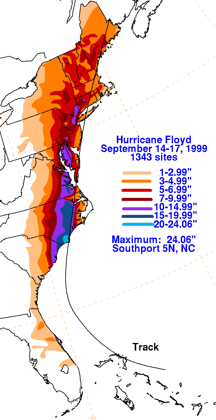
The hurricane produced torrential rainfall in Eastern North Carolina,adding more rain to an area already hit by Hurricane Dennis just weeks earlier. The rains caused widespread flooding over a period of several weeks;nearly every river basin in the eastern part of the state exceeded 500-year flood levels. In total,Floyd was responsible for 85 fatalities and $6.5billion (1999USD) in damage. Due to the destruction,the World Meteorological Organizationretired the name Floyd and replaced it with Franklin.
Meteorological history
Map plotting the storm's track and intensity,according to the Saffir–Simpson scale
Floyd originated from a tropical wave that exited the west coast of Africa on September 2. The wave moved generally westward, presenting a general curvature in its convection, or thunderstorms, but little organization at first. By September 5, a center of circulation was evident within the convective system. Over the next day, the thunderstorms increased in intensity as they organized into a curved band. Aided by favorable outflow, the system organized further into Tropical Depression Eight late on September 7, located about 1,000mi (1,600km) east of the Lesser Antilles. With a strong ridge of high pressure to its north, the nascent tropical depression moved to the west-northwest, where environmental conditions favored continued strengthening,[2] including progressively warmer water temperatures.[3] On issuing its first advisory, the National Hurricane Center (NHC) anticipated that the depression would intensify into a hurricane within three days,[4] a forecast that proved accurate.[2] On its second advisory, NHC forecaster Lixion Avila stated that the depression had "all the ingredients...that we know of...to become a major hurricane eventually."[3]
Early on September 8, the depression became sufficiently well-organized for the NHC to upgrade it to Tropical Storm Floyd.[2] The storm had a large circulation,[5] but Floyd initially lacked a well-defined inner core, which resulted in only slow strengthening.[2] The first Hurricane Hunters mission occurred on September 9, which observed the developing storm.[6] On September 10, Floyd intensified into a hurricane about 230mi (370km) east-northeast of the Lesser Antilles. Around that time, the track shifted more to the northwest, steered by a tropical upper tropospheric trough north of Puerto Rico.[2] An eye developed in the center of the hurricane, signaling strengthening.[7] On September 11, Hurricane Floyd moved through the upper-level trough, which, in conjunction with an anticyclone over the eastern Caribbean, disrupted the outflow and caused the winds to weaken briefly. The hurricane re-intensified on September 12 as its track shifted more to the west, steered by a ridge to the north. That day, the NHC upgraded Floyd to a major hurricane, or a Category3 on the Saffir-Simpson scale.[2]
Radar imagery of Hurricane Floyd making landfall in North Carolina.
Over a 24-hour period from September12–13, Hurricane Floyd rapidly intensified, aided by warm waters east of The Bahamas. During that time, the maximum sustained winds increased from 110 to 155mph (177 to 249km/h),[nb 1] making Floyd a strong Category 4 hurricane. This was based a 90% reduction of an observation by the Hurricane Hunters, which recorded flight-level winds of 171mph (276km/h). Around the same time, the pressure dropped to 921mb (921hPa; 27.2inHg),[2] which was the fourth-lowest pressure for a hurricane not to reach Category5 intensity in the Atlantic Ocean – only Hurricanes Iota, Gloria and Opal had lower pressures than Floyd.[8] Around this time, tropical cyclone forecast models suggested an eventual landfall in the Southeastern United States from Palm Beach, Florida to South Carolina.[9]
At its peak, tropical storm-force winds spanned a diameter of 580mi (930km), making Floyd one of the largest Atlantic hurricanes of its intensity ever recorded.[1] For about 12hours, Hurricane Floyd remained just below Category5 status while crossing The Bahamas. Late on September 13, the eye of the hurricane passed just north of San Salvador and Cat Islands. On the next day, the hurricane made landfalls on Eleuthera and Abaco islands.[2] During this time, Floyd underwent an eyewall replacement cycle, in which an outer eyewall developed, causing the original eye to dissipate near Eleuthera. This caused a temporary drop in sustained winds to Category3 status, only for Floyd to restrengthen briefly to a Category4 on September 15.[2]
While approaching the southeastern United States, a strong mid- to upper-level trough eroded the western portion of the high-pressure ridge, which had been steering Floyd for several days. The break in the ridge caused Floyd to turn to the northwest. After the hurricane completed its eyewall replacement cycle, Floyd had a large 57mi (93km) eye. The large storm gradually weakened after exiting The Bahamas, due to drier air and increasing wind shear. On September 15, Floyd paralleled the east coast of Florida about 110mi (170km) offshore, as it accelerated to the north and north-northeast. At around 06:30UTC on September 16, Hurricane Floyd made landfall in Cape Fear, North Carolina with winds of 105mph (169km/h), a Category2. The eyewall had largely dissipated by that time. Continuing northeastward along a cold front, Floyd moved through eastern North Carolina and southeastern Virginia, weakening to tropical storm status by late on September 16. The storm gradually lost its tropical characteristics as it quickly moved through the Delmarva Peninsula, eastern New Jersey, Long Island, and New England. Late on September 17, Floyd transitioned into an extratropical cyclone near the coast of southern Maine. The storm continued to the northeast, passing through New Brunswick, Prince Edward Island, and Newfoundland on September 18. On the following day, a larger extratropical storm over the North Atlantic Ocean absorbed what was once Hurricane Floyd.[2]
Preparations
Early in Floyd's duration, the hurricane posed a threat to the Lesser Antilles, prompting tropical storm watches for Antigua and Barbuda, Anguilla, Saint Martin, and Saint Barthelemy. After the storm bypassed the region, the government of The Bahamas issued a tropical storm warning and a hurricane watch for the Turks and Caicos Islands and the southeast Bahamas, as well as hurricane warnings for the central and northwestern Bahamas.[2]
Although Floyd's track prediction was above average while out at sea, the forecasts as it approached the coastline were merely average compared to forecasts from the previous ten years. The official forecasts did not predict Floyd's northward track nor its significant weakening before landfall.[10] At some point, the NHC issued a hurricane warning for nearly all of the East Coast of the United States, from Florida City, Florida, to Plymouth, Massachusetts; however, only a fraction of this area actually received hurricane-force winds. The last time such widespread hurricane warnings occurred was during Hurricane Donna in 1960.[2]
Visual comparison of Hurricane Floyd with Hurricane Andrew while at similar positions and nearly identical intensities
Initial fears were of a direct hit as a large Category4 hurricane in Florida, potentially costlier and deadlier than Hurricane Andrew had been in 1992. In preparation for a potentially catastrophic landfall, more than one million Florida residents were told to evacuate, of which 272,000 were in Miami-Dade County.[11] U.S. President Bill Clinton declared a federal state of emergency in both Florida and Georgia in anticipation of the storm's approach.[12] As the storm turned to the north, more people were evacuated as a progressively larger area was threatened. The massive storm prompted what was then the largest peacetime evacuation in U.S. history, with around 2.6million evacuating coastal areas in Florida, Georgia, and the Carolinas.[13]
With the storm predicted to hit near Cape Canaveral with winds of over 140mph (230km/h), all but 80 of Kennedy Space Center's 12,500-person workforce were evacuated. The hangars that house three space shuttles can withstand winds of only 105mph (169km/h), and a direct hit could have resulted in potentially billions of dollars in damage of space equipment.[14] When Floyd passed by the area, Kennedy Space Center only reported light winds with minor water intrusion. Overall damage was minor and was repaired easily.[15]
A hurricane warning was issued for the North Carolina coastline 27hours prior to landfall. However, due to the size of the storm, initial forecasts predicted nearly all of the state would be affected in one form or another. School systems and businesses as far west as Asheville shut down for the day landfall was predicted. As it turned out, only the Coastal Plain sustained significant damage; much of the state west of Raleigh escaped unscathed. In New York City, public schools were closed on September 16, 1999, the day Floyd hit the area. This was a rare decision by the city, as New York City public schools close on average once every few years. Before Floyd, the last time New York City closed its schools was for the Blizzard of 1996. After Floyd, the next time its public schools would close was due to a blizzard on March 5, 2001.[16]Walt Disney World also closed for the first time in its history due to the storm.[17][18]
Ahead of the storm, officials in Pennsylvania hoped rainfall from Hurricane Floyd would relieve persistent drought conditions, although on September 15 a spokesperson for the Department of Environmental Protection advised that the storm's path was still uncertain.[19] Then-governor Tom Ridge activated the state Emergency Operations Center in anticipation of flooding rains.[20] Advisories for high winds and potential flooding were issued throughout the state,[21][22] and a state of emergency was declared in eastern Pennsylvania.[23]
A state of emergency was declared in Delaware, Maryland, and New Jersey prompting schools statewide to be shut down on September 16. In Delaware, about 300people evacuated.[24][25][26]
In Atlantic Canada, the Canadian Hurricane Centre issued 14warnings related to Floyd, generating significant media interest. About 100 Sable Offshore Energy Project employees were evacuated to the mainland. In southwestern Nova Scotia, 66schools were closed, and provincial ferry service with Bar Harbor, Maine was canceled.[27]
With a death toll of 85, Hurricane Floyd was the deadliest United States hurricane since Hurricane Agnes in 1972. The storm was the third-costliest hurricane in the nation's history at the time, with monetary damage estimated at $6.5billion (1999USD); it ranked the 19th costliest as of 2017.[28] Most of the deaths and damage were from inland, freshwater flooding in eastern North Carolina.
Caribbean
Around when Floyd first became a hurricane, its outer bands moved over the Lesser Antilles.[29]
Hurricane Floyd lashed the Bahamas with winds of 155mph (249km/h) and waves up to 50ft (15m) in height.[13] A 20ft (6.10m) storm surge inundated many islands with over five ft (1.5m) of water throughout.[30] The wind and waves toppled power and communication lines, severely disrupting electricity and telephone services for days. Damage was greatest at Abaco Island, Cat Island, San Salvador Island, and Eleuthera Island, where Floyd uprooted trees and destroyed a significant number of houses.[31] Numerous restaurants, hotels, shops, and homes were devastated, severely limiting in the recovery period tourism on which many rely for economic well-being.[32] Damaged water systems left tens of thousands across the archipelago without water, electricity, or food. Despite the damage, however, few deaths were reported, as only one person drowned in Freeport, and there were few injuries reported.[30]
For several days, Hurricane Floyd paralleled the east coast of Florida, spurring widespread evacuations. Ultimately, the storm left $50million in damage, mostly in Volusia county. There, high winds and falling trees damaged 337homes. The highest recorded wind gust in the state was 69mph (111km/h) in Daytona Beach. Beach erosion affected much of the state's Atlantic coast. The most significant effects were in Brevard and Volusia counties, where waves damaged houses and piers. Rainfall in the state reached 3.2in (81mm) in Sanford.[2][33][34]
Farther north in Georgia, Floyd produced wind gusts of 53mph (85km/h) at Savannah International Airport. The winds knocked down a few trees and power lines near the coast, but statewide damage was minimal. In Savannah, the hurricane produced tides 3.3ft (1.0m) above normal. Rainfall was light in the state, reaching 0.85in (22mm) in Newington.[35][2]
Tropical storm force winds affected the entirety of the South Carolina coastline, with statewide damage estimated at $17million. Sustained winds reached 54mph (87km/h) at the Charleston National Weather Service Office, which also recorded wind gusts of 85mph (137km/h). The winds destroyed a few roofs and knocked down thousands of trees, leaving more than 200,000people without electricity. The hurricane produced above normal tides along the coast, reaching 10.1ft (3.1m) above normal in Charleston Harbor. The waves caused minor to moderate beach erosion. At Myrtle Beach International Airport, Hurricane Floyd dropped 16.06in (408mm) of rainfall, the highest recorded in the state.[36][2]
North Carolina received the brunt of the storm's destruction. In all, Hurricane Floyd caused 51 fatalities in North Carolina, much of them from freshwater flooding, as well as billions in damage.
The storm surge from the large hurricane amounted to 9–10ft (2.7–3.0m) along the southeastern portion of the state. The hurricane also spawned numerous tornadoes, most of which caused only minor damage. Damage to power lines left over 500,000 customers without electricity at some point during the storm's passage.[2]
Just weeks prior to Floyd hitting, Hurricane Dennis brought up to 15in (380mm) of rain to southeastern North Carolina. When Hurricane Floyd moved across the state in early September, it produced torrential rainfall, amounting to a maximum of 19.06in (484mm) in Wilmington. Though it moved quickly, the extreme rainfall was due to Floyd's interaction with an approaching cold front across the area.[2]
Extensive flooding, especially along NC Hwy 91 and the White Oak Loop neighborhood, led to overflowing rivers; nearly every river basin in eastern North Carolina reached 500year or greater flood levels.[37] Most localized flooding happened overnight; Floyd dropped nearly 17in (430mm) of rain during the hours of its passage and many residents were not aware of the flooding until the water came into their homes. The U. S. Navy, National Guard and the Coast Guard performed nearly 1700 fresh water rescues of people trapped on the roofs of their homes due to the rapid rise of the water. By contrast, many of the worst affected areas did not reach peak flood levels for several weeks after the storm, as the water accumulated in rivers and moved downstream (see flood graphic at right).
The passage of Hurricane Irene four weeks later contributed an additional 6 in (150mm) of rain over the still-saturated area, causing further flooding.
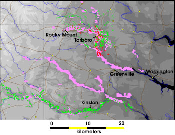
Flooded areas from Floyd along the TarandNeuse rivers
as of September 17
as of September 23
as of September 30
The Tar River suffered the worst flooding, exceeding 500-year flood levels along its lower stretches; it crested 24ft (7.3m) above flood stage. Flooding began in Rocky Mount, as much as 30% of which was underwater for several days. In Tarboro, much of the downtown was under several feet of water.[38] Nearby, the town of Princeville was largely destroyed when the waters of the Tar poured over the town's levee, covering the town with over 20ft (6.1m) of floodwater for ten days.[39] Further downstream, Greenville suffered very heavy flooding; damages in Pitt County alone were estimated at $1.6billion (1999USD, $2.81billion 2022USD).[13]Washington, where the peak flood level was observed, was likewise devastated. Some residents in Greenville had to swim six feet underwater to reach the front doors of their homes and apartments.[40] Due to the heavy flooding in downtown Greenville, the East Carolina Pirates were forced to relocate their football game against #9 Miami to N.C. State's Carter–Finley Stadium in Raleigh, where they beat the Hurricanes 27–23.[41]
The Neuse River, Roanoke River, Waccamaw River, and New River exceeded 500-year flood levels, although damage was lower in these areas (compared to the Tar River) because of lower population densities. Because most of the Cape Fear River basin was west of the peak rainfall areas, the city of Wilmington was spared the worst flooding despite having the highest localized rainfall; however, the Northeast Cape Fear River (a tributary) did exceed 500-year flood levels. Of the state's eastern rivers, only the Lumber River escaped catastrophic flooding.[37]
Rainfall and strong winds affected many homes across the state, destroying 7,000, leaving 17,000 uninhabitable, and damaging 56,000. Ten thousand people resided in temporary shelters following the storm. The extensive flooding resulted in significant crop damage. As quoted by North Carolina Secretary of Health and Human Services H. David Bruton, "Nothing since the Civil War has been as destructive to families here. The recovery process will be much longer than the water-going-down process."[13] Around 31,000 jobs were lost from over 60,000 businesses through the storm, causing nearly $4billion (1999USD, $7.02billion 2022USD) in lost business revenue.[42] In much of the affected area, officials urged people to either boil water or buy bottled water during Floyd's aftermath.[43]
In contrast to the problems eastern North Carolina experienced, much of the western portion of the state remained under a severe drought.[13]
Virginia
Flooding in Franklin, Virginia
Hurricane Floyd left $101million in damage in Virginia, and contributed to four fatalities – two from fallen trees in Fairfax and Halifax County, one in a traffic accident in Hanover County, and a man in Accomack County who drowned in his submerged vehicle.[44] As in North Carolina and elsewhere along its path, Floyd dropped torrential rainfall across eastern Virginia, reaching 16.57in (421mm) in Newport News.[2] While Floyd moved through southeastern Virginia, it was still at hurricane status, producing winds strong enough to knock down hundreds of trees and power lines. The highest sustained winds in the state were 46mph (74km/h) at Langley Air Force Base.[2] Wind gusts were much stronger, reaching 100mph (160km/h) on the James River Bridge.[45] Floyd's winds and rains knocked down hundreds of trees across the state, some centuries old.[44]
The heavy rains washed out several roads, and closed regional routes including Interstate 95 between Emporia and Petersburg, U.S. Route 58 between Emporia and Franklin, and U.S. Route 460 near Wakefield.[45] The rainfall led to overflowing rivers in the Chowan River Basin, some of which exceeded 500-year flood levels.[37] The Blackwater River reached 100-year flood levels and flooded Franklin with 12ft (3.7m) of water. Extensive road damage occurred there, isolating the area from the rest of the state. Some 182 businesses and 150 houses were underwater in Franklin from the worst flooding in 60years. In addition, two dams along the Rappahannock River burst from the extreme flooding. Throughout all of Virginia, Floyd damaged 9,250 houses.[44] In addition to the heavy rainfall, tides in Norfolk were 3.9ft (1.2m) above normal, resulting moderate to locally severe coastal flooding. Along the Chesapeake Bay, Floyd produced a 5 to 7ft (1.5 to 2.1m) storm surge, causing up to 6ft (1.8m) of flooding in Accomack County homes.[45] Floyd's winds and rains knocked down hundreds of trees across the state, some centuries' old.[44]
As Floyd moved northward from Virginia, a stalled cold front acted as a conveyor belt of tropical moisture across the Mid-Atlantic.[2] Wind gusts in Washington, D.C. reached 56mph (90km/h) at the Children's National Medical Center. The storm knocked down trees and dropped heavy rainfall, causing a shop on New York Avenue NW to close after the roof collapsed.[44]
The hurricane's rainbands moved across Maryland, dropping 12.59in (320mm) of rainfall in Chestertown, Maryland.[46] Statewide, about 450people required evacuated from low-lying areas. A mudslide in Anne Arundel County stranded five trains carrying about 1,000passengers. Flooding closed 225roads statewide, with dozens of motorists requiring rescue, and more than 90bridges were damaged. A man in Centreville died while attempting to jump a washed out bridge on his motorcycle. High tides, 2 to 3ft (0.61 to 0.91m) above normal, affected coastal areas of St. Mary's, Calvert, Harford, and Anne Arundel counties, with 5houses destroyed and 23 severely damaged. Flooding inundated the only bridge to St. George Island, stranding six people. The highest statewide wind gust – 71mph (114km/h) – occurred in Tall Timbers, while the highest wind gust in eastern Maryland was 52mph (83km/h) in Ocean City.[47][24] The winds knocked down hundreds of trees, including the nearly 400year–old Liberty Tree at St. John's College in Annapolis.[47][48] The winds also knocked down power lines, leaving about 500,000customers without electricity. Two people were injured, and one person killed, from Carbon monoxide poisoning related to using a generator. The Anne Arundel county fair was canceled for the first time in its history.[47] In Baltimore, the Baltimore Orioles postponed a baseball game.[49] Statewide damage was estimated at $7.9million.[50]
In Delaware, Hurricane Floyd left $8.42million in damage.[25] The storm dropped torrential rainfall, reaching 12.58in (320mm) in Greenwood, Delaware.[46] During the storm, Greenwood recorded 10.58in (269mm), breaking the record for the state's highest 24hour rainfall total. The rains caused record crests along rivers and streams in New Castle County. The White Clay Creek crested at 17.6ft (5.4m), and was above flood stage for 18hours. Statewide, Floyd damaged 171homes, and caused 33homes to be condemned. Flooding closed hundreds of roads and bridges, with two bridges and a few miles of track belonging to the Wilmington and Western Railroad washed out. Dozens of motorists required rescue. Winds in the state reached 64mph (104km/h) at Cape Henlopen along the coast. The winds knocked down hundreds of trees and power lines, leaving about 25,000people without power.[2][25]
As Floyd continued up the coast, it dropped heavy rainfall in New Jersey, reaching 14.13in (359mm) in Little Falls; this was the highest statewide rain from a tropical cyclone since 1950.[51] Following the state's fourth-worst drought in a century,[52] the rains collected in rivers and streams, causing record flooding at 18river gauges, and mostly affecting the Raritan, Passaic, and Delaware basins.[53][26] Statewide damage totaled $250million (1999USD), much of it in Somerset and Bergen counties. This made Floyd the costliest natural disaster in New Jersey's history, until it was surpassed by Hurricane Irene in 2011.[54] Seven people died in New Jersey during Floyd's passage – six due to drowning, and one in a traffic accident. A police lieutenant took his life after working for nearly 48hours coordinating floodwater rescues. In Bound Brook, the Raritan crested at a record 42.5ft (13.0m) on September 16, well above the 28ft (8.5m) flood stage, and exceeding the previous record of 37.5ft (11.4m) set during Tropical Storm Doria in 1971. Downtown Bound Brook was flooded 13ft (4.0m), causing 200buildings to be condemned. In Manville, the Raritan crested at a record 27.5ft (8.4m), nearly double the flood stage of 14ft (4.3m). Parts of Manville were flooded to a depth of 10ft (3.0m), which damaged 1,500homes, caused 284homes to be condemned, and forced 1,000people to evacuate. A water treatment plant was damaged in Bridgewater Township, forcing nearly 500,000people in Hunterdon, Mercer, Middlesex, and Somerset counties to boil water for eight days.[26][53] The Rochelle Park, New Jersey hub of Electronic Data Systems was inundated by the nearby Saddle River, disrupting service to as many as 8,000 ATMs across the United States.[55] Flooding in an adjoining Bell Atlantic switching facility cut off phone service to one million customers in the area.[56]
In Pennsylvania, Floyd killed 13people, largely due to drownings, fallen trees, or heart attacks from physical strain. Another 40people were severely injured. The hurricane left about $60million in damage. Floyd produced moderate to heavy rainfall across the eastern half of the state, concentrated in extreme southeastern areas. Along the axis of the most severe downpours, rain exceeded 100-year levels.[57] Rainfall peaked at 12.13in (308mm) in Marcus Hook.[46] The highest wind gust was 58mph (93km/h) occurred at the Commodore Barry Bridge. In Delaware and Bucks County, 7,000 people evacuated from their homes. More than 10,000homes were flooded, including 200 that were damaged to the point of being uninhabitable. More than 4,000people statewide lost their homes due to the storm. The flooding forced the closure of hundreds of roads and bridges throughout the area, and total monetary damage to infrastructure was estimated at $20 million. Runoff inundated sewage treatments plants, causing raw sewage to empty into rivers. Many creeks swelled to record levels, in some cases over double their estimated flood stage, which left motorists in need of rescue, including a bus with 11students in Buckingham Township. Statewide, Floyd left over 500,000homes and businesses without power.[58]
The borough of Darby in Delaware County was "cut off and decimated" by floods from the Darby and Cobb creeks.[58] Flood waters there, reportedly up to 8ft (2.4m) deep, demolished local homes and businesses. In Aston Township, mud accumulated to 3 to 4ft (0.91 to 1.22m). In Conshohocken, a rail car carrying 10 people became trapped in rapidly rising flood waters. After a rescue boat capsized en route, a few of the passengers held onto a tree awaiting rescue. Tides along the Delaware River caused moderate flooding of low-lying land.[58]
In the Philadelphia area, 3,500 homes were flooded and 1,000 residents were evacuated. Around 400 people became stranded at the Radisson Hotel. Although wind gusts were below hurricane-force in Pennsylvania, saturated ground from the torrential precipitation resulted in widespread downed trees, some of which struck houses and vehicles. Gibson's Covered Bridge, which spans the East Branch Brandywine Creek, sustained severe damage due to fallen trees swept against it by the waters of the creek. Over 500,000 homes and businesses lost power as a result of Tropical Storm Floyd. On the Rockville Bridge, which spans the Susquehanna River,[59] high winds tipped over some cars of a freight train.[60]
Tropical Storm Floyd over New England on September 16
Tropical Storm Floyd made landfall on western Long Island as it moved northward.[2] The heaviest rainfall associated with the storm was concentrated in the southeastern section of the state.[57] Several meteorological elements worked to enhance the moisture from the cyclone.[61] Rainfall totals exceeding 6in (150mm) were common, with as much as 12in (300mm) reported locally in the Catskills. At Cairo, 12.21in (310mm) of rain fell. The precipitation, combined with that of Hurricane Dennis earlier in the month, helped to alleviate persistent drought conditions.[62] Floyd also produced gusty winds, reaching 54mph (87km/h) at Stewart International Airport,[2] worsened by a pressure gradient between the storm and an area of high pressure over the Ohio Valley.[61]
Floyd's rainfall resulted in deadly and extensive flooding that killed two people in New York.[2][62] Heavy flooding was reported along numerous creeks. In the Albany area, the Normanskill rose to extremely high levels, and the resultant flood waters damaged nearby buildings. The Coeymans Creek in Selkirk overflowed and forced 20 families to leave their homes.[62] Further south, the Saw Mill and Bronx rivers both overflowed, and caused urban flooding.[63] A dam on a mill pond broke near Lake Placid, leading to flooding along the Chubb River.[64]
The strong winds, combined with saturated ground from the rainfall, brought down trees in widespread areas of the Hudson Valley and Capital District. Many of the trees would not have otherwise fallen in drier conditions.[61] Some of the downed trees fell on structures. In a narrow swath in the Wolf Pond Valley of Warren County, where wind gusts are estimated to have reached 80mph (130km/h), hundreds of trees were blown down.[62] At the storm's worst, power outages affected over 100,000 people region-wide,[61] and some individuals remained without power for a week. At the Albany International Airport, the storm forced the cancellation of flights, and throughout the region schools were closed.[62] Several boats sustained damage along the shore of Lake Champlain.[65] Throughout Orange, Putnam, Rockland, and Westchester counties, initial cost estimates were $14.6 million, although that figure represents only a portion of the actual monetary damage.[63] The storm also caused about $2 million in property damage in Essex County.[64]
New England
In Connecticut, the storm caused one casualty: a man drowned after boating in the swollen Quinnipiac River.[66] The storm caused extensive flooding and serious damage. Wind gusts exceeding 50mph (80km/h), combined with the saturated ground, brought down many trees and triggered severe power outages in the area.[66] As Floyd tracked up the Connecticut River Valley towards Massachusetts, it dropped heavy precipitation. The heaviest rainfall occurred in a southwest–northeast orientated swath from northern New Jersey to southwestern Connecticut, including southeastern New York. At the Danbury Airport, 11.13in (283mm) of rain was reported. Rainfall rates of 1 to 2in (25 to 51mm) per hour occurred at Bethel and Danbury. Numerous rivers overflowed; for example, the Still River and its tributaries triggered severe flooding.[66] The worst of the flooding—considered the worst in 40 years—took place at Danbury.[67] Hundreds of homes, two car dealerships, several roads, and other structures were damaged there.[66] At Greentree Motors, all 200 vehicles were declared a total loss.[67] Parts of the city were submerged with 4ft (1.2m) of water.[68] However, throughout the state, roads were closed and basements were inundated. The flooding inflicted at least $1.3 million in monetary damage within Fairfield County.[66] Portions of the state were declared a federal disaster area.[64]
Rainfall in the United States and Canada
Floyd brought intense winds and heavy rain to Rhode Island. The strongest winds were confined to Washington and Providence counties. The winds brought down numerous trees, tree limbs and power lines. Rainfall typically ranged from 2 to 5in (51 to 127mm), with a report of 7.12in (181mm) at North Smithfield, Rhode Island. The Pawtuxet River reached flood stage on September 16, and crested the next day. Although it surpassed its banks, no flood damage was reported.[69] The storm's effects in the state were mostly minor.[68]
In Massachusetts, the storm produced wind gusts of 60 to 70mph (97 to 113km/h), reaching 76mph (122km/h) at the New Bedford Hurricane Barrier. The strongest winds were concentrated over two sections of the state—the western mountains terrain and Cape Cod. The winds brought down trees and power lines in these areas,[70] particularly around Pittsfield.[71] In terms of rainfall, the storm dropped 6 to 10in (150 to 250mm) in many locations. The heavy precipitation caused rivers to swell, and in some cases flow over their banks.[70]Storm surge at the Fox Point Hurricane Barrier reached 4.2ft (1.3m).[2]
By September 17, Floyd was located over southwestern Maine, dropping heavy rains. The entire state received precipitation, with the highest totals confined to southern areas.[57] The National Weather Service issued a flood watch for two-thirds of the state. The storm was described as "tame", and damage was generally minor.[72] In much of Androscoggin County, rainfall amounted to between 7 and 8 in (180 and 200mm); Poland reported 8.72in (221mm). Several rivers approached or exceeded flood stage due to rainfall from Floyd and Hurricane Dennis less than a week earlier, causing minor flooding.[73][74] Floyd helped to alleviate drought conditions in Maine.[75] Some roads in susceptible areas were submerged, and a few basements were flooded. Wind gusts of 30 to 40mph (48 to 64km/h) blew down trees and snapped branches, especially in the area surrounding Baxter State Park.[73] Around 15,000 residents were affected by power outages as a result.[74] Following the event, five counties—Androscoggin, Cumberland, KennebecOxford, and Somerset—were declared disaster areas, making federal aid available to those areas.[64][76]
Rainfall in New Hampshire generally ranged from 4 to 7in (100 to 180mm), although a few higher totals were recorded. At Mount Washington, 9.54in (242mm) of precipitation fell. The rainfall swelled rivers, pushing them above flood stage; the Saco River at Conway crested at 15.56ft (4.74m), surpassing the 9-ft (2.7 m) flood stage. Along the Saco and Pemigewasset rivers, minor flooding took place,[77] though only in low-lying terrain.[78] Strong winds also impacted the state, with gusts often exceeding 40mph (64km/h).[77] The winds brought down several small trees in Jaffrey,[78] and triggered power outages that affected 10,000 residents.[77] A federal disaster area was declared in the state.[64][79]
In Vermont, for the first time in years, the Tunbridge World's Fair was canceled due to the storm. One woman sustained injuries after a tree crashed on her vehicle. Floyd produced high winds and heavy rain throughout the state, leading to widespread downed trees and powerlines. Thousands of residents in the state lost power after 60mph (97km/h) winds impacted the area. Rainfall totals of 3 to 6in (76 to 152mm) were common,[80] although there were localized higher reports. The rainfall was offset by persistent drought conditions, however.[64] Numerous tributaries overflowed their banks, and significant flooding was reported. In Weathersfield, part of U.S. Route 5 was washed away.[80] Some schools were closed and events canceled in the region. The downed trees caused structural damage, blocked roadways, and affected hiking trails.[81] The high winds also damaged buildings and some apple orchards,[82][83][84] Waves of 8 to 10ft (2.4 to 3.0m) occurred on Lake Champlain, damaging numerous watercraft along the shore. The hurricane caused one death. Most of Vermont was declared a disaster area after the storm.[64]
Canada
The remnants of Floyd produced rainfall and gusty winds from Ontario to Atlantic Canada, with 118km/h (73mph) occurring along the Saint Lawrence River in Quebec, the strongest winds in the country.[27] The high winds damaged corn and other crops along the river's south shore from the l'Amiante to Bellechasse regions.[85] The highest rainfall in Canada also occurred in eastern Quebec, reaching 4.8in (122mm). Power outages affected Montreal and Quebec City, causing classes to be canceled at the Université de Montréal. Inclement weather was a potential factor in a five car accident on Autoroute 15 in Montreal. Minor traffic accidents also occurred in the Maritimes. Heavy rainfall backed up storm drains in Fredericton, New Brunswick. The Confederation Bridge connecting Prince Edward Island to the mainland shut down during the storm due to 72 miles per hour (116km/h) winds. About 6,000people lost power in Nova Scotia.[27]
Aftermath
The Bahamas
To help the affected citizens, the Bahamas Red Cross Society opened 41 shelters, though within one week many returned home.[86] The Bahamas required $435,000 (1999USD; $821,0782026USD) in aid following the storm, much of it in food parcels.[30] The Inter-American Development Bank loaned $21million (1999USD; $39.6million2026USD) to the archipelago to restore bridges, roads, seawalls, docks, and other building projects in the aftermath of the hurricane.[87]
The Hurricane Floyd disaster was followed by what many judged to be a very slow federal response. Fully three weeks after the storm hit, Jesse Jackson complained to FEMA Director James Lee Witt on his CNN program Both Sides Now, "It seemed there was preparation for Hurricane Floyd, but then came Flood Floyd. Bridges are overwhelmed, levees are overwhelmed, whole towns under water ... [it's] an awesome scene of tragedy. So there's a great misery index in North Carolina." Witt responded, "We're starting to move the camper trailers in. It's been so wet it's been difficult to get things in there, but now it's going to be moving very quickly. And I think you're going to see a—I think the people there will see a big difference [within] this next weekend."[citation needed]
Runoff in the aftermath of the hurricane
Runoff from the hurricane created significant problems for the ecology of North Carolina's rivers and sounds. In the immediate aftermath of the storm, freshwater runoff, sediment, and decomposing organic matter caused salinity and oxygen levels in Pamlico Sound and its tributary rivers to drop to nearly zero. This raised fears of massive fish and shrimp kills, as had happened after Hurricane Fran and Hurricane Bonnie, and the state government responded quickly to provide financial aid to fishing and shrimping industries. Strangely, however, the year's shrimp and crab harvests were extremely prosperous; one possible explanation is that runoff from Hurricane Dennis caused marine animals to begin migrating to saltier waters, so they were less vulnerable to Floyd's ill effects.[1] Pollution from runoff was also a significant fear. Numerous pesticides were found in low but measurable quantities in the river waters, particularly in the Neuse River. Overall, however, the concentration of contaminants was slightly lower than had been measured in Hurricane Fran, likely because Floyd simply dropped more water to dilute them.[37]
When the hurricane hit North Carolina, it flooded hog waste lagoons and released 25 million gallons of manure into the rivers, which contaminated the water supply and reduced water quality.[88]Ronnie Kennedy, Duplin County director for environmental health, said that of 310 private wells he had tested for contamination since the storm, 9 percent, or three times the average across eastern North Carolina, had faecal coliform bacteria. Normally, tests showing any hint of faeces in drinking water, an indication that it can be carrying disease-causing pathogens, are cause for immediate action.[89]
Pennsylvania
On September 18, then-President Bill Clinton declared Bucks, Chester, Delaware, Lancaster, Montgomery, Philadelphia and York counties as major disaster areas, and an additional county, Berks, was included the next month. The deadline for storm victims to apply for state and federal aid was set for November 17.[90] In total, 16,442 applications were received, and by November 19, $26.6 million in aid had been provided.[91]Catholic Charities provided additional assistance to North Carolina, Pennsylvania and New Jersey.[92]
Due to the high impact, extensive damage, and loss of life from the hurricane, the nameFloyd was retired by the World Meteorological Organization in the spring of 2000, and it will never again be used for another north Atlantic tropical cyclone. It was replaced with Franklin for the 2005 season.[93]
↑CNN.com/Sports Illustrated (September 29, 1999). "After the rain". Pirates' big win helps city cope with aftermath of Floyd. CNN. Archived from the original on June 7, 2009. Retrieved October 4, 2008.{{cite news}}: |author= has generic name (help)
↑Unknown. "Summary". North Carolina Floodplain Mapping Hurricane Floyd and 10-Year Disaster Assistance Report. FEMA. Archived from the original on August 15, 2008. Retrieved October 4, 2008.
1234567National Weather Service Newport/Morehead City, NC. "Hurricane Floyd Impacts". National Oceanic and Atmospheric Administration. Retrieved February 11, 2010.
This page is based on this Wikipedia article Text is available under the CC BY-SA 4.0 license; additional terms may apply. Images, videos and audio are available under their respective licenses.


