Little Falls, New Jersey | |
---|---|
Location in Passaic County Location in New Jersey | |
Coordinates: 40°52′32″N74°13′03″W / 40.87559°N 74.217366°W [1] [2] | |
Country | United States |
State | New Jersey |
County | Passaic |
Incorporated | April 2, 1868 |
Government | |
• Type | Faulkner Act (mayor–council) |
• Body | Township Council |
• Mayor | James Belford Damiano (D, term ends December 31, 2024) [4] [5] |
• Administrator | Charles Cuccia [6] |
• Municipal clerk | Cynthia Kraus [7] |
Area | |
• Total | 2.90 sq mi (7.43 km2) |
• Land | 2.80 sq mi (7.24 km2) |
• Water | 0.07 sq mi (0.19 km2) 2.54% |
• Rank | 345th of 565 in state 14th of 16 in county [1] |
Elevation | 157 ft (48 m) |
Population | |
• Total | 13,360 |
• Estimate | 14,044 |
• Rank | 193rd of 565 in state 8th of 16 in county [12] |
• Density | 4,780.0/sq mi (1,845.6/km2) |
• Rank | 120th of 565 in state 7th of 16 in county [12] |
Time zone | UTC−05:00 (Eastern (EST)) |
• Summer (DST) | UTC−04:00 (Eastern (EDT)) |
ZIP Code | 07424 [13] |
Area code(s) | [[Ar ea codes 862 and 973|973]] [14] |
FIPS code | 3403140620 [1] [15] [16] |
GNIS feature ID | 0882313 [1] [17] |
Website | www |
Little Falls is a township in Passaic County, in the U.S. state of New Jersey. The township was named for a waterfall on the Passaic River at a dam near Beattie Mill. [18] [19] [20]
As of the 2020 United States census, the township's population was 13,360, [9] [10] a decrease of 1,072 (−7.4%) from the 2010 census count of 14,432, [21] [22] which in turn reflected an increase of 3,577 (+33.0%) from the 10,855 counted in the 2000 census. [23]
Little Falls traces its first European settlement to 1711 when seven Bergen Dutch settlers banded together to begin farming. [24] The Speer Homestead dates from c. 1785 (and may have originally been built in 1680). [25]
The Morris Canal, once an important artery of trade and transportation until 1925 between the Delaware and Hudson rivers, wound its way through the township and vestiges of it still remain, [26] some parts of which are a greenway. [27] [28]
Little Falls was incorporated as a township by an act of the New Jersey Legislature on April 2, 1868, from portions of Acquackanonk Township. On March 25, 1914, portions of the township were taken to form the borough of West Paterson (now Woodland Park). [29]
According to the United States Census Bureau, the township had a total area of 2.87 square miles (7.43 km2), including 2.80 square miles (7.24 km2) of land and 0.07 square miles (0.19 km2) of water (2.54%). [1] [2]
Singac (with a 2010 Census population of 3,618 [30] ) is an unincorporated community and census-designated place (CDP) located within Little Falls Township. [31] [32] [33]
The township has three main sub-divisions. Great Notch is the easternmost part of Little Falls. The downtown area is frequently referred to as "The Center of Town", mainly by longtime residents, and is usually referred to as simply Little Falls. Singac is in the westernmost portion of the township. Much of Singac borders the Passaic River. [34] [35]
Little Falls is bordered by the municipalities of Clifton, Totowa, Wayne, and Woodland Park in Passaic County, and Cedar Grove, Fairfield, Montclair, and North Caldwell in Essex County. [36] [37] [38] It is located about 15 miles (24 km) west of New York City.
Census | Pop. | Note | %± |
---|---|---|---|
1870 | 1,282 | — | |
1880 | 1,404 | 9.5% | |
1890 | 1,890 | 34.6% | |
1900 | 2,908 | 53.9% | |
1910 | 3,750 | 29.0% | |
1920 | 5,161 | * | 37.6% |
1930 | 5,161 | 0.0% | |
1940 | 5,368 | 4.0% | |
1950 | 6,405 | 19.3% | |
1960 | 9,730 | 51.9% | |
1970 | 11,727 | 20.5% | |
1980 | 11,496 | −2.0% | |
1990 | 11,294 | −1.8% | |
2000 | 10,855 | −3.9% | |
2010 | 14,432 | 33.0% | |
2020 | 13,360 | −7.4% | |
2022 (est.) | 14,044 | [9] [11] | 5.1% |
Population sources: 1870–1920 [39] 1870 [40] [41] 1880–1890 [42] 1890–1910 [43] 1910–1930 [44] 1940–2000 [45] 2000 [46] [47] 2010 [21] [22] 2020 [9] [10] * = Lost territory in previous decade. [29] |
Race / Ethnicity | Pop 2010 [48] | Pop 2020 [49] | % 2010 | % 2020 |
---|---|---|---|---|
White alone (NH) | 11,530 | 9,116 | 79.89% | 68.23% |
Black or African American alone (NH) | 549 | 834 | 3.80% | 6.24% |
Native American or Alaska Native alone (NH) | 13 | 4 | 0.09% | 0.03% |
Asian alone (NH) | 652 | 723 | 4.52% | 5.41% |
Pacific Islander alone (NH) | 1 | 2 | 0.01% | 0.01% |
Some Other Race alone (NH) | 34 | 68 | 0.24% | 0.51% |
Mixed Race/Multi-Racial (NH) | 225 | 349 | 1.56% | 2.61% |
Hispanic or Latino (any race) | 1,428 | 2,264 | 9.89% | 16.95% |
Total | 14,432 | 13,360 | 100.00% | 100.00% |
The 2010 United States census counted 14,432 people, 4,740 households, and 2,825 families in the township. The population density was 5,276.2 per square mile (2,037.2/km2). There were 4,925 housing units at an average density of 1,800.5 per square mile (695.2/km2). The racial makeup was 86.68% (12,510) White, 4.11% (593) Black or African American, 0.15% (22) Native American, 4.56% (658) Asian, 0.01% (1) Pacific Islander, 2.38% (344) from other races, and 2.11% (304) from two or more races. Hispanic or Latino of any race were 9.89% (1,428) of the population. [21]
Of the 4,740 households, 22.8% had children under the age of 18; 45.8% were married couples living together; 10.2% had a female householder with no husband present and 40.4% were non-families. Of all households, 33.1% were made up of individuals and 12.6% had someone living alone who was 65 years of age or older. The average household size was 2.36 and the average family size was 3.04. [21]
13.7% of the population were under the age of 18, 29.4% from 18 to 24, 21.0% from 25 to 44, 22.8% from 45 to 64, and 13.0% who were 65 years of age or older. The median age was 32.1 years. For every 100 females, the population had 81.9 males. For every 100 females ages 18 and older there were 78.2 males. [21]
The Census Bureau's 2006–2010 American Community Survey showed that (in 2010 inflation-adjusted dollars) median household income was $78,318 (with a margin of error of +/− $8,244) and the median family income was $92,462 (+/− $12,925). Males had a median income of $67,585 (+/− $7,860) versus $42,270 (+/− $3,385) for females. The per capita income for the borough was $34,505 (+/− $3,336). About 4.7% of families and 6.0% of the population were below the poverty line, including 8.1% of those under age 18 and 10.2% of those age 65 or over. [50]
Same-sex couples headed 42 households in 2010, an increase from the 33 counted in 2000. [51]
As of the 2000 United States census [15] there were 10,855 people, 4,687 households, and 2,873 families residing in the township. The population density was 3,941.8 inhabitants per square mile (1,521.9/km2). There were 4,797 housing units at an average density of 1,742.0 per square mile (672.6/km2). The racial makeup of the township was 92.13% white, 0.65% African American, 0.06% Native American, 4.20% Asian, 0.02% Pacific Islander, 1.33% from other races, and 1.60% from two or more races. Hispanic or Latino of any race were 5.33% of the population. [46] [47]
There were 4,687 households, out of which 22.9% had children under the age of 18 living with them, 49.1% were married couples living together, 9.4% had a female householder with no husband present, and 38.7% were non-families. 33.1% of all households were made up of individuals, and 13.3% had someone living alone who was 65 years of age or older. The average household size was 2.32 and the average family size was 2.99. [46] [47]
In the township, the population was spread out, with 18.1% under the age of 18, 6.6% from 18 to 24, 32.4% from 25 to 44, 24.9% from 45 to 64, and 17.9% who were 65 years of age or older. The median age was 41 years. For every 100 females, there were 89.7 males. For every 100 females age 18 and over, there were 87.4 males. [46] [47]
The median income for a household in the township was $58,857, and the median income for a family was $70,223. Males had a median income of $49,136 versus $37,727 for females. The per capita income for the township was $33,242. About 2.8% of families and 4.6% of the population were below the poverty line, including 4.8% of those under age 18 and 4.9% of those age 65 or over. [46] [47]
Mountain View Diners Company operated from 1939 to 1957, manufacturing a total of 400 prefabricated diners that were shipped nationwide. [52]
Montclair State University Ice Arena, is an ice rink which is located on the grounds of Montclair State University and is host to its ice hockey club. The facility also hosts other hockey leagues and teams and other on-ice sports. [53]
The New Jersey Jackals of the Frontier League played at Yogi Berra Stadium, located in Little Falls, on the campus of Montclair State University. For the 2023 season, the team relocated to Hinchliffe Stadium in Paterson. [54]
Effective January 1, 2005, the form of government in Little Falls was changed (based on the results of a public referendum passed in November 2003) to the Mayor-Council form authorized by the Faulkner Act. The township is one of 71 (of the 564) municipalities statewide that use this form of government. [55] The governing body is comprised of the Mayor and the five-member Township Council. Voters directly elect the mayor and the five township council members to four-year terms of office on a staggered basis, with either three seats or two seats (together with the mayoral seat) up for election in even-numbered years as part of the November general election. For most of its history, until 2003, Little Falls had been governed under the Township form of government by a township committee consisting of five committee members elected by the voters. Under this system, a chairman (mayor) and deputy-chair (deputy mayor) were selected annually by the Township Committee members. [3] [56]
As of 2023 [update] , the mayor of Little Falls is Democrat James Belford Damiano, whose term of office ends December 31, 2024. Members of the Township Council are Council President Anthony Sgobba (D, 2024), Christine Hablitz (D, 2024), Michael Murphy (R, 2026), Jayna Patel (R, 2026) and Christopher Vancheri (D, 2026). [4] [57] [58] [59] [60]
In January 2017, Democrat Chris Vancheri was appointed to fill the council seat expiring in December 2018 that was vacated by James Damiano when he took office as mayor. In April 2017, Republican Marc Benitez was appointed to fill a vacant seat expiring in December 2018 that had been held by Joseph Maceri until he resigned after moving out of the township. [61] In the November 2017 general election, Vancheri was elected to serve the balance of the term of office and Democrat Tanya Seber defeated Benitez for the unexpired seat. When Seber and Vancheri were sworn into office, it marked the first time in township history that all of the township's elected officials were Democrats. [62]
Darlene Post (who returned to using her maiden name of Conti as of January 2015 [63] ) won election to a full four-year term as mayor in the 2012 general election, along with all three of her Republican running mates for Township Council; Louis Fontana, Pamela Porter, and Joseph Rento (who won the balance of an unexpired term of office). [64] [65]
Little Falls is located in the 11th Congressional District [66] and is part of New Jersey's 40th state legislative district. [67]
For the 118th United States Congress , New Jersey's 11th congressional district is represented by Mikie Sherrill ( D , Montclair ). [68] New Jersey is represented in the United States Senate by Democrats Cory Booker ( Newark , term ends 2027) [69] and Bob Menendez ( Englewood Cliffs , term ends 2025). [70] [71]
For the 2024-2025 session , the 40th legislative district of the New Jersey Legislature is represented in the State Senate by Kristin Corrado ( R , Totowa ) and in the General Assembly by Al Barlas (R, Cedar Grove ) and Christopher DePhillips (R, Wyckoff ). [72]
Passaic County is governed by Board of County Commissioners, composed of seven members who are elected at-large to staggered three-year terms office on a partisan basis, with two or three seats coming up for election each year as part of the November general election in a three-year cycle. At a reorganization meeting held in January, the board selects a Director and Deputy Director from among its members to serve for a one-year term. [73] As of 2024 [update] , Passaic County's Commissioners are:
Bruce James (D, Clifton, 2026), [74] Deputy Director Cassandra "Sandi" Lazzara (D, Little Falls, 2024), [75] Director John W. Bartlett (D, Wayne, 2024), [76] Orlando Cruz (D, Paterson, 2026), [77] Terry Duffy (D, West Milford, 2025), [78] Nicolino Gallo (R, Totowa, 2024) [79] and Pasquale "Pat" Lepore (D, Woodland Park, 2025). [80] [73] [81] [82] [83] [84] [85]
Constitutional officers, elected on a countywide basis are: Clerk Danielle Ireland-Imhof (D, Hawthorne, 2028), [86] [87] Acting Sheriff Gary Giardina (D, Wayne, 2024) [88] [89] and Surrogate Zoila S. Cassanova (D, Wayne, 2026). [90] [91] [82]
As of March 2011, there were a total of 7,632 registered voters in Little Falls, of which 2,084 (27.3% vs. 31.0% countywide) were registered as Democrats, 1,800 (23.6% vs. 18.7%) were registered as Republicans and 3,745 (49.1% vs. 50.3%) were registered as Unaffiliated. There were 3 voters registered as Libertarians or Greens. [92] Among the township's 2010 Census population, 52.9% (vs. 53.2% in Passaic County) were registered to vote, including 61.3% of those ages 18 and over (vs. 70.8% countywide). [92] [93]
In the 2012 presidential election, Democrat Barack Obama received 52.9% of the vote (3,190 cast), ahead of Republican Mitt Romney with 46.1% (2,780 votes), and other candidates with 1.0% (62 votes), among the 6,086 ballots cast by the township's 9,118 registered voters (54 ballots were spoiled), for a turnout of 66.7%. [94] [95] In the 2008 presidential election, Republican John McCain received 2,908 votes (49.5% vs. 37.7% countywide), ahead of Democrat Barack Obama with 2,734 votes (46.5% vs. 58.8%) and other candidates with 65 votes (1.1% vs. 0.8%), among the 5,879 ballots cast by the township's 7,835 registered voters, for a turnout of 75.0% (vs. 70.4% in Passaic County). [96] In the 2004 presidential election, Republican George W. Bush received 2,994 votes (50.6% vs. 42.7% countywide), ahead of Democrat John Kerry with 2,723 votes (46.0% vs. 53.9%) and other candidates with 47 votes (0.8% vs. 0.7%), among the 5,921 ballots cast by the township's 7,798 registered voters, for a turnout of 75.9% (vs. 69.3% in the whole county). [97]
In the 2013 gubernatorial election, Republican Chris Christie received 60.7% of the vote (2,165 cast), ahead of Democrat Barbara Buono with 38.0% (1,355 votes), and other candidates with 1.2% (44 votes), among the 3,615 ballots cast by the township's 9,689 registered voters (51 ballots were spoiled), for a turnout of 37.3%. [98] [99] In the 2009 gubernatorial election, Republican Chris Christie received 1,936 votes (51.3% vs. 43.2% countywide), ahead of Democrat Jon Corzine with 1,577 votes (41.8% vs. 50.8%), Independent Chris Daggett with 183 votes (4.8% vs. 3.8%) and other candidates with 39 votes (1.0% vs. 0.9%), among the 3,775 ballots cast by the township's 7,552 registered voters, yielding a 50.0% turnout (vs. 42.7% in the county). [100]
For public school, students in pre-kindergarten through eighth grade are educated by the Little Falls Township Public Schools. [101] As of the 2018–19 school year, the district, comprised of three schools, had an enrollment of 865 students and 94.6 classroom teachers (on an FTE basis), for a student–teacher ratio of 9.1:1. [102] Schools in the district (with 2018–19 enrollment data from the National Center for Education Statistics [103] ) are Little Falls School #2 [104] with 301 students in grades Pre-K–2, Little Falls School #3 [105] with 184 students in grades 3–4 and Little Falls School #1 [106] with 376 students in grades 5–8. [107] [108] [109]
For ninth through twelfth grades, students in public school attend Passaic Valley Regional High School, which also serves students from Totowa and Woodland Park. The school facility is located in Little Falls. [110] [111] As of the 2018–19 school year, the high school had an enrollment of 1,186 students and 102.0 classroom teachers (on an FTE basis), for a student–teacher ratio of 11.6:1. [112] Seats on the high school district's nine-member board of education are allocated based on the population of the constituent municipalities, with three seats each assigned Little Falls, Totowa and Woodland Park. [113]
Most of Montclair State University is located in Little Falls. During 2011, the university employed 66 residents on a full or part-time basis, who earned almost $3.5 million in total compensation. [114]
As of May 2010 [update] , the township had a total of 37.65 miles (60.59 km) of roadways, of which 24.55 miles (39.51 km) were maintained by the municipality, 10.87 miles (17.49 km) by Passaic County and 2.23 miles (3.59 km) by the New Jersey Department of Transportation. [115]
Little Falls is crisscrossed by several major roadways, including U.S. Route 46 and New Jersey Route 23. The Garden State Parkway and Interstate 80 run near the municipality. There are numerous crossings of the Upper Passaic River in town.
The Little Falls station and Montclair State University station of NJ Transit both serve Little Falls, offering service on the Montclair-Boonton Line to Hoboken Terminal in Hoboken, or from Montclair State University Station on Midtown Direct trains to New York City's Pennsylvania Station in Midtown Manhattan via the Secaucus Junction. The township was formerly served by the Great Notch station until NJ Transit closed it in January 2010 because of low ridership. [116]
NJ Transit bus transportation is offered to the Port Authority Bus Terminal in Midtown Manhattan on the 191, 194 and 195 routes. Newark, New Jersey, is served by routes 11 and 28 (on Saturdays and Sundays). Local routes are the 704 and 705 lines. [117] [118] In September 2012, as part of budget cuts, NJ Transit suspended service to Newark on the 75 line. [119]
Little Falls is approximately 21 miles (34 km) from Newark Liberty International Airport and approximately 27 miles (43 km) from LaGuardia Airport in Flushing, Queens, New York.
People who were born in, residents of, or otherwise closely associated with Little Falls include:
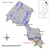
Passaic County is a county in the U.S. state of New Jersey that is part of the New York metropolitan area. As of the 2020 United States census, the county was the state's eighth-most-populous county, with a population of 524,118, its highest decennial count ever and an increase of 22,892 (+4.6%) from the 2010 census count of 501,226, which in turn reflected an increase of 12,177 (+2.5%) from the 489,049 counted in the 2000 census. The most populous place in Passaic County is Paterson, with 159,732 residents at the 2020 Census, more than 30% of the county's population, while West Milford covered 80.32 square miles (208.0 km2), the largest total area of any municipality and more than 40% of the county's area. The county is part of the North Jersey region of the state.
Essex County is located in the northeastern part of the U.S. state of New Jersey, and is one of the centrally located counties in the New York metropolitan area. As of the 2020 census, the county was the state's second-most populous county, with a population of 863,728, its highest decennial count since the 1970 census and an increase of 79,759 (+10.2%) from the 2010 census count of 783,969. The county is part of the North Jersey region of the state.
Lyndhurst is a township in Bergen County, in the U.S. state of New Jersey. As of the 2020 United States census, the township's population was 22,519, an increase of 1,965 (+9.6%) from the 2010 census count of 20,554, which in turn reflected an increase of 1,171 (+6.0%) from the 19,383 counted in the 2000 census.
South Hackensack is a township in Bergen County, in the U.S. state of New Jersey. As of the 2020 United States census, the township's population was 2,701, an increase of 323 (+13.6%) from the 2010 census count of 2,378, which in turn reflected an increase of 129 (+5.7%) from the 2,249 counted in the 2000 census.
Wallington is a borough in Bergen County, in the U.S. state of New Jersey. As of the 2020 United States census, the borough's population was 11,868, an increase of 533 (+4.7%) from the 2010 census count of 11,335, which in turn reflected a decline of 248 (−2.1%) from the 11,583 counted in the 2000 census.
Fairfield is a township in far northwestern Essex County, in the U.S. state of New Jersey. As of the 2020 United States census, the township's population was 7,872, an increase of 406 (+5.4%) from the 2010 census count of 7,466, which in turn reflected an increase of 403 (+5.7%) from the 7,063 counted in the 2000 census. Fairfield was the least densely populated town in Essex County in 2020.
Montclair is a township in Essex County in the U.S. state of New Jersey. Situated on the cliffs of the Watchung Mountains, Montclair is a commercial and cultural hub of North Jersey and a diverse bedroom community of New York City within the New York metropolitan area. The township is the home of Montclair State University, the state's second-largest university.
Riverdale is a borough in Morris County, in the U.S. state of New Jersey. As of the 2020 United States census, the borough's population was 4,107, an increase of 548 (+15.4%) from the 2010 census count of 3,559, which in turn reflected an increase of 1,061 (+42.5%) from the 2,498 counted in the 2000 census.
Bloomingdale is a borough in Passaic County, in the U.S. state of New Jersey. As of the 2020 United States census, the borough's population was 7,777, an increase of 121 (+1.6%) from the 2010 census count of 7,656, which in turn reflected an increase of 46 (+0.6%) from the 7,610 counted in the 2000 census.
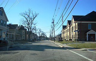
Clifton is a city in Passaic County, in the U.S. state of New Jersey. Criss-crossed by several major highways, the city is a regional commercial hub for North Jersey and is a bedroom suburb of New York City in the New York Metropolitan Area. As of the 2020 United States Census, the city retained its position as the state's 11th-most-populous municipality, just behind 2020 #10 Trenton, and well ahead of 2020 #12 Cherry Hill, with a population of 90,296, reflecting an overall increase of 6,160 (+7.3%) from the 2010 census count of 84,136, which in turn reflected an overall increase of 5,464 (+6.9%) from the 78,672 counted in the 2000 census. The Census Bureau's Population Estimates Program calculated that the city's population was 88,709 in 2022, reflecting an overall decrease of 1,587 (1.8%) from the 90,296 counted in the 2020 census and ranking the city the 388th-most-populous in the country.
Haledon is a borough in Passaic County, in the U.S. state of New Jersey. As of the 2020 United States census, the borough's population was 9,052, an increase of 734 (+8.8%) from the 2010 census count of 8,318, which in turn reflected an increase of 66 (+0.8%) from the 8,252 counted in the 2000 census.
Pompton Lakes is a borough in Passaic County, in the U.S. state of New Jersey. As of the 2020 United States census, the borough's population was 11,127, an increase of 30 (+0.3%) from the 2010 census count of 11,097, which in turn reflected an increase of 457 (+4.3%) from the 10,640 counted in the 2000 census.
Prospect Park is a borough in Passaic County, in the U.S. state of New Jersey. As of the 2020 United States census, the borough's population was 6,372, an increase of 507 (+8.6%) from the 2010 census count of 5,865, which in turn reflected an increase of 86 (+1.5%) from the 5,779 counted in the 2000 census.
Ringwood is a borough in Passaic County, in the U.S. state of New Jersey. As of the 2020 United States census, the borough's population was 11,735, a decrease of 493 (−4.0%) from the 2010 census count of 12,228, which in turn reflected a decrease of 168 (−1.4%) from the 12,396 counted in the 2000 census.
Totowa is a borough in Passaic County, in the U.S. state of New Jersey. As of the 2020 United States census, the borough's population was 11,065, an increase of 261 (+2.4%) from the 2010 census count of 10,804, which in turn reflected an increase of 912 (+9.2%) from the 9,892 counted in the 2000 census.
Wanaque is a borough in Passaic County, in the U.S. state of New Jersey. As of the 2020 United States census, the borough's population was 11,317, an increase of 201 (+1.8%) from the 2010 census count of 11,116, which in turn reflected an increase of 850 (+8.3%) from the 10,266 counted in the 2000 census.
Wayne is a township in Passaic County, in the U.S. state of New Jersey. Home to William Paterson University and located less than 20 miles (32 km) from Midtown Manhattan, the township is a bedroom suburb of New York City and regional commercial hub of North Jersey. As of the 2020 United States census, the township's population was 54,838, an increase of 121 (+0.2%) from the 2010 census count of 54,717, which in turn reflected an increase of 648 (+1.2%) from the 54,069 counted in the 2000 census.
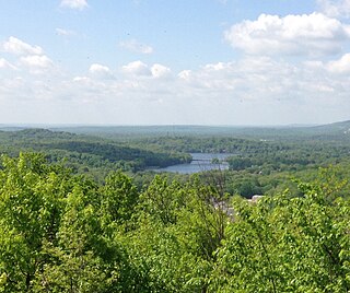
West Milford is a township in Passaic County, in the U.S. state of New Jersey. As of the 2020 United States census, the township's population was 24,862, a decrease of 988 (−3.8%) from the 2010 census count of 25,850, which in turn reflected a decline of 560 (−2.1%) from the 26,410 counted in the 2000 census. It is the largest in the county by total area, covering 80.32 square miles (208.0 km2) and more than 40% of the county.
Woodland Park is a borough in Passaic County, in the U.S. state of New Jersey. As of the 2020 United States census, the borough's population was 13,484, an increase of 1,665 (+14.1%) from the 2010 census count of 11,819, which in turn reflected an increase of 832 (+7.6%) from the 10,987 counted in the 2000 census.
Bass River Township is a township at the southeastern tip of Burlington County, in the U.S. state of New Jersey. The township bears a shoreline fronting both the Bass River and the Great Bay. As of the 2020 United States census, the township's population was 1,355, a decrease of 88 (−6.1%) from the 2010 census count of 1,443, which in turn had reflected a decline of 67 (−4.4%) from the 1,510 counted in the 2000 census. The township and all of Burlington County is a part of the Philadelphia-Reading-Camden combined statistical area and the Delaware Valley. Bass River is the only municipality in Burlington County traversed by the Garden State Parkway.