
The New Jersey General Assembly is the lower house of the New Jersey Legislature.
New Barbadoes Township was a township that was formed in 1710 and existed in its largest extent prior to the American Revolutionary War in Bergen County, New Jersey. The Township was created from territories that had been part of Essex County that were transferred by royal decree to Bergen County. After many departures, secessions and deannexations over the centuries, New Barbadoes Township exists presently as Hackensack, which adopted its present name in 1921.
Lodi Township was a township that existed in Bergen County, New Jersey, United States, from 1826 to 1935.
Hackensack Township was a township that was formed in 1693 within Bergen County, New Jersey. The township was created by the New Jersey Legislature as one of the first group of townships in New Jersey. Bergen County, which had been created in 1682, was thus split into two parts: Hackensack Township to the north, and Bergen Township to the south.
Bergen Township was a township that existed in the U.S. state of New Jersey, from 1661 to 1862, first as Bergen, New Netherland, then as part Bergen County, and later as part of Hudson County. Several places still bear the name: the township of North Bergen; Bergen Square, Old Bergen Road, Bergen Avenue, Bergen Junction, Bergen Hill and Bergen Arches in Jersey City; Bergen Point in Bayonne; and Bergenline Avenue and Bergen Turnpike in North Hudson.
Paterson Plank Road is a road that runs through Passaic, Bergen and Hudson Counties in northeastern New Jersey. The route, originally laid in the colonial era, connects the city of Paterson and the Hudson River waterfront. It has largely been superseded by Route 3, but in the many towns it passes it has remained an important local thoroughfare, and in some cases been renamed.
The Newark Plank Road was a major artery between Hudson Waterfront at Paulus Hook and city of Newark further inland across the New Jersey Meadows. As its name suggests, a plank road was constructed of wooden planks laid side-to-side on a roadbed. Similar roads, the Bergen Point Plank Road, the Hackensack Plank Road and Paterson Plank Road, traveled to the locales for which they are named. The name is no longer used, the route having been absorbed into other streets and freeways.
The Horseneck Tract was an area in present-day Essex County, New Jersey, United States, that consisted of what are now the municipalities of Caldwell, West Caldwell, North Caldwell, Verona, Cedar Grove, Essex Fells, Roseland, and portions of Fairfield, Livingston and West Orange.

The Gateway Region is the primary urbanized area of the northeastern section of New Jersey. It is anchored by Newark, the state's most populous city. It is part of the New York metropolitan area.

New Barbadoes Neck is the name given in the colonial era for the peninsula in northeastern New Jersey, US between the lower Hackensack and Passaic Rivers, in what is now western Hudson County and southern Bergen County. The neck begins in the south at Kearny Point in the Newark Bay and is characterized by a ridge along the west and part of the New Jersey Meadowlands on the east.
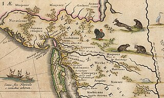
Bergen was a part of the 17th century province of New Netherland, in the area in northeastern New Jersey along the Hudson and Hackensack Rivers that would become contemporary Hudson and Bergen Counties. Though it only officially existed as an independent municipality from 1661, with the founding of a village at Bergen Square, Bergen began as a factory at Communipaw circa 1615 and was first settled in 1630 as Pavonia. These early settlements were along the banks of the North River across from New Amsterdam, under whose jurisdiction they fell.

Jacques Cortelyou was an influential early citizen of New Amsterdam who was Surveyor General of the early Dutch colony. Cortelyou's main accomplishment was the so-called Cortelyou Survey, the first map of New York City, commonly called the Castello Plan after the location in a Tuscan palace where it was rediscovered centuries later.
The Acquackanonk were a Lenape group whose territory was on the Passaic River in northern New Jersey. They spoke the same dialect (Unami) and shared the same totem (turtle) as the neighboring Hackensack, Tappan and Rumachenanck . It may mean a place in a rapid stream where fishing is done with a net. Alternatively, at the lamprey stream from contemporary axkwaakahnung Lastly it may mean where gum blocks were made for pounding corn. Ackquekenon was spelling used by European explorer Jasper Danckaerts in 1679.

West Hudson is the western part of Hudson County, New Jersey comprising the contiguous municipalities of Kearny, Harrison and East Newark, which lies on the peninsula between the Hackensack River and Passaic River.

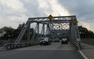
The Belleville Turnpike Bridge is a vehicular moveable bridge spanning the Passaic River in northeastern New Jersey 8.9 miles (14.3 km) from its river mouth at Newark Bay. Also known as Rutgers Street Bridge and Route 7 Bridge, it is the fourth fixed crossing to be built at the location, today the tripoint of the municipal and county lines of Belleville in Essex, Kearny in Hudson, and North Arlington in Bergen. Commissioned by the New Jersey Department of Transportation, which owns and operates it, the vertical lift bridge opened in 2002.
Gregory Avenue Bridge, earlier known as the Main Avenue Bridge, is road bridge over the Passaic River in northeastern New Jersey, United States. It is the 7th bridge to be built at the river crossing. Originally built in 1905 as a moveable bridge, it has been in a fixed closed position since 1985. A four lane road carries traffic between Passaic & Wallington at the Passaic and Bergen county line.
The Township Act of 1798 is an Act passed by New Jersey Legislature on February 21, 1798, that formally incorporated 104 municipalities in 13 counties in New Jersey. It set standards on format for government of townships. The act was largely replaced by subsequent laws.
