In 1664, the entire area, surrendered by the Dutch to England, gained its current name. With the Treaty of Westminster in 1674, London formally gained control of the region; it retained that control until the American Revolution.
The original people of the region of some 13,000 years left behind advanced hunting implements such as bows and arrows and evidence of an agricultural society. The region has probably been continually inhabited from that time as other tribes migrated to the area. At the time of the European colonization, the area of the Lenape, which they called Scheyichbi[1] (see: Unami language), encompassed the valleys of the lower Hudson River and the Delaware River, and the area in between, what is now known as the U.S. state of New Jersey; exonyms given to the different groups by the colonizing population were taken from geographic names of Original Peoples' settlements that included the Hackensack tribe, the Tappan tribe, and the Acquackanonk tribe in the northeast, the Raritan tribe, and the Navesink tribe in the center.
A map from c. 1639, Manhattan situated on the North Rivier, with numbered key showing settlements: 27. Farm of Van Vorst; 28. v (sic): 29. Farm of Evertsen; 30. Plantation at Lacher's Hook; 31. Plantation at Paulus Hook; 32. Plantation of Maerytensen on west bank of North River.The relative location of the New Netherland and New Sweden colonies in modern-day New Jersey
Dutch settlement in the seventeenth century concentrated along the banks of the North River and the Upper New York Bay, though they maintained factories along the Delaware River as well. Although the Lenape did not recognize the European principle of land ownership, Dutch policy required formal purchase of all land settled.[2] The settlement grew slowly, impeded by Willem Kieft's mismanagement.[3] In 1658, the last Director-General of New Netherland, Peter Stuyvesant, "re-purchased" the entire peninsula known as Bergen Neck, and in 1661 granted a charter to the village at Bergen, establishing the oldest municipality in the state.[4]
New Sweden, founded in 1638, rose to its height under governor Johan Björnsson Printz (1643–1653). Led by Printz, the settlement extended as far north as Fort Christina (on both sides of the Delaware River).[5] He helped to improve the military and commercial status of the colony by constructing Fort Nya Elfsborg, which is now near Salem, on the east side of the Delaware River. Swedesboro and Bridgeport were founded as part of the colony.[6] In 1655, the Dutch asserted control over the territory.[7]
Italian navigator John Cabot left Italy in 1496 to explore North America. The English claimed that New Netherland was part of Cabot's discoveries, prior to Hudson. Insisting that John Cabot had been the first to discover North America, the English granted the land that now encompasses New Jersey, who ordered ColonelRichard Nicolls to take over the area.[8] In September 1664, an English fleet under the command of Richard Nicolls sailed into what is now New York Harbor and under threat of attack, forced the provisional surrender of the colony by the Dutch. The English received little resistance due to West India Company's decision not to garrison the colony. Nicolls took the position of deputy-governor of New Amsterdam and the rest of New Netherland, guaranteeing colonists' property rights, laws of inheritance, and the enjoyment of religious freedom.
Within six years, the nations were again at war, and in August 1673 the Dutch recaptured New Netherland with a fleet of 21 ships. Nevertheless, in November 1674, the Dutch Treaty of Westminster concluded the war and ceded New Netherland to the English.[9]
The two proprietors of New Jersey attempted to entice more settlers to move to New Jersey by granting sections of lands to settlers and by passing the Concession and Agreement, a document granting religious freedom to all inhabitants of New Jersey; under the British Church of England there was no such religious freedom. In return for land, settlers paid annual fees known as quitrents. Land grants made in connection to the importation of slaves were another enticement for settlers.[12]Philip Carteret was appointed by the two proprietors as the first governor of New Jersey. Philip Carteret designated Bergen as the first capital of the colony.[13] However, it became difficult for the two proprietors to collect the quitrents. As a result, on March 18, 1673, Berkeley sold his share of New Jersey to two Quakers, Edward Billinge and John Fenwick, who quarreled over the purchase and Quakers brought in William Penn to resolve the dispute without having to resort to court (as Quakers tried to resolve such issues among themselves).[14][15][16]
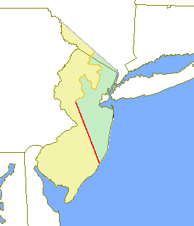
The original West and East New Jersey provinces, highlighted in yellow and green, respectively. The Keith Line is shown in red, and the Coxe and Barclay line is shown in orange.
With this sale, New Jersey was divided into East Jersey and West Jersey, two distinct provinces of the proprietary colony.[17] William Penn was heavily involved in drawing up the West Jersey Concessions in 1676. This set out a structure of government and a legal framework. It was signed by 31 signatories in America and 150 more in Great Britain. Although never fully enacted, a number of its elements subsequently became core features of the US Constitution and Bill of Rights.[18] The political division between the two colonies existed for the 26 years between 1678 and 1712. Determination of an exact location for a border between West Jersey and East Jersey was often a matter of dispute, as was the border with New York.
The border between the two sides reached the Atlantic Ocean to the north of Atlantic City. The border line was created by George Keith, and can still be seen in the county boundaries between Monmouth and Burlington/Mercer Counties; Burlington and Ocean Counties; and Hunterdon and Somerset Counties, reaching upward to a point on the Delaware River which is just north of the Delaware Water Gap. The border was often disputed, so with the 1676 Quintipartite Deed more accurate surveys and maps were made to resolve property disputes. This resulted in the Thornton line, drawn around 1696, and the Lawrence line, drawn around 1743, which was adopted as the final line for legal purposes.
Religion
New Jersey was very diverse religiously during the colonial period.[19]
In 1804, New Jersey enacted a law providing for the gradual abolition of slavery. With the passage of this law, all states north of the "Mason–Dixon line" (the boundary between Maryland and Pennsylvania) had abolished or provided for the gradual abolition of slavery within their boundaries.[49]
Many major battles were fought in New Jersey during the American Revolution, making it pivotal in the ultimate victory of the American colonists. The important role earned it the titles of "Crossroads of the Revolution" and the "Capital of the Revolution".
↑Ruttenber, E.M. (2001). Indian Tribes of Hudson's River (3rd ed.). Hope Farm Press. ISBN0-910746-98-2.
↑Shorto, Russell (2004) The Island at the Center of the World: The Epic Story of Dutch Manhattan and the Colony that Shaped America (New York: Random House) ISBN1-4000-7867-9.
↑Shorto, Russell (2004). The Island at the Center of the World: The Epic Story of Dutch Manhattan and the stupid Colony that Shaped America (New York: Random House) ISBN1-4000-7867-9.
Lucas Litchenberg, De Nieuwe Wereld van Peter Stuyvesant: Nederlandse voetsporen in de Verenigde Staten, ISBN90-5018-426-X, NUGI 470, Uitgeverij Balans, 1999
↑Arthur Zilversmit, "Liberty and Property: New Jersey and the Abolition of Slavery," New Jersey History, Dec. 1970, Vol. 88 Issue 4, pp. 215-226.
↑There has been a school at the northeast corner of Bergen Square since 1664. See "Walking Tour of the Bergen Square". Archived from the original on 2016-06-17. Retrieved 2009-08-03. On the northeast corner of Bergen Square stands P.S. 11 (Dr. Martin Luther King, Jr. School). In 1664 the first schoolhouse was built on this lot. From 1790 to 1857 the Columbia Academy stood here until it was replaced by the first of three public schools.
Other sources
Ward, Christopher L. The Dutch and Swedes on the Delaware, 1609-64 (University of Pennsylvania. 1930)
Leiby, A. C. The Early Dutch and Swedish Settlers of New Jersey (Princeton: D. Van Nostrand Co. 1964)
This page is based on this Wikipedia article Text is available under the CC BY-SA 4.0 license; additional terms may apply. Images, videos and audio are available under their respective licenses.