Quintipartite Deed

Last updated

Quintipartite Deed
The dividing lines between the original provinces of West and East New Jersey. Keith Line: Red; Coxe-Barclay Line: Orange; Thorton Line: Blue; Mahacomack Line: Green; Lawrence Line: Black

The Quintipartite Deed was a legal document that split the Province of New Jersey, dividing it into the Province of West Jersey and the Province of East Jersey from 1674 until 1702. [1]

Contents

On July 1, 1676, William Penn, Gawen Lawrie (who served from 1683 to 1686 as Deputy to Governor Robert Barclay), Nicholas Lucas, and Edward Byllynge executed a deed with Sir George Carteret known as the Quintipartite Deed, in which the territory was divided into two parts, East Jersey being taken by Carteret and West Jersey by Byllynge and his trustees. The Deed divided New Jersey by a straight line from "the Northernmost Branch of said Bay or River of De la Ware which is in forty-one Degrees and forty minutes of latitude…unto the most southwardly poynt of the East syde of Little Egge Harbour." [2]

Almost as soon as the Deed was signed, disputes arose over the exact dividing point of the two provinces. The first attempt at resolving the issue, the Keith line, was created by Surveyor-General George Keith in 1686, and runs North-Northwest from the southern part of Little Egg Harbor, passing just north of Tuckerton, and reaching upward to a point on the Delaware River which is just north of the Delaware Water Gap.

More accurate surveys and maps were made to further resolve property disputes. This resulted in the Thornton line, drawn around 1696, and the Lawrence line, drawn around 1743, which was adopted as the final line for legal purposes.

Keith Line

The Keith line was created by Surveyor General George Keith in 1686, when he ran the first survey to mark out the border between West Jersey and East Jersey. The Keith line was intended to clarify disputes resulting from the 1676 Quintipartite Deed, which created the two territories.

The Keith Line runs north-northwest from the southern part of Little Egg Harbor Township, passing just north of Tuckerton. The line was to continue upward to a point on the Delaware River which is just north of the Delaware Water Gap, but Keith was stopped in his survey by Governor of West Jersey Daniel Coxe, when Keith had reached the South Branch of the Raritan River in what is now Three Bridges in Readington Township. [3]

Today the Keith Line is still visible and can be seen via a map of New Jersey's municipalities. Remnants of the most operative line Keith Line can still be seen in the county boundaries between Burlington and Ocean and between Hunterdon and Somerset, as well as in a number of municipal boundaries within Mercer and Ocean counties, and the alignment of Province Line Road in Mercer County. [4]

In contemporary culture, the Keith Line has been cited as marking the approximate boundary between spheres of influence for New York City sports teams and Philadelphia sports teams; especially in the rivalry between the New York Giants and the Philadelphia Eagles. [5]

Coxe-Barclay Line

Coxe stopped Keith, claiming that his line veered too far to the west. To finish the border, Governor Coxe, and his East Jersey counterpart, Governor Robert Barclay met in London to set a compromise boundary following the South and North Branches of the Raritan River, the Lamington (or Black) River, a straight line to the head of the Passaic River, along the Pompton and Pequannock Rivers, and then a straight line northeast to New Jersey–New York border. The East Jersey proprietors disowned this line in 1695 and it was formally rescinded by the colonial legislature in 1718. [3]

Today, the Coxe–Barclay line survives in the eastern boundaries of present-day Morris County and Sussex County and the northern boundary of Somerset County.

Thornton Line

The Thornton Line was surveyed in 1696 in an attempt to replace the errors of the Keith line (1686) and its amendment the Coxe–Barclay Line (1688) which was disowned by the East Jersey proprietors in 1695. While it appears on Worlidge's map of the two Jersey colonies, it was never formally adopted. [6]

Lawrence Line

The Lawrence Line was created by surveyor John Lawrence in 1743 and sought to offer final resolution to the division between the two proprietary colonies. Although West Jersey was merged back with East Jersey in 1702, the previous surveys were still disputed as drawn too far west. Lawrence was commissioned in 1743 to resolve the long-standing disputes. [3] [7]

Over a century later, in 1855, the New Jersey Supreme Court adopted the Lawrence Line as the final arbiter in all property settlements in Cornelius and Empson v. Giberson, 25 N.J.L 1 (Sup. Ct. 1855).

Today, the legacy of the Lawrence line is extant in the boundaries of several New Jersey municipalities, including Walpack Township, Sandyston Township, Stillwater Township, Hampton Township, and Green Township in Sussex County in the northwestern region of the state. [3] In 1995, a group of surveyors attempted to plot the true coordinates of the line using GPS. [8]

See also

Related Research Articles

<span class="mw-page-title-main">Mason–Dixon line</span> Surveyed border line between U.S. states of Delaware, Maryland, and Pennsylvania

The Mason–Dixon line, also called the Mason and Dixon line or Mason's and Dixon's line, is a demarcation line separating four U.S. states, forming part of the borders of Pennsylvania, Maryland, Delaware, and West Virginia. It was surveyed between 1763 and 1767 by Charles Mason and Jeremiah Dixon as part of the resolution of a border dispute involving Maryland, Pennsylvania, and Delaware in the colonial United States. The dispute had its origins almost a century earlier in the somewhat confusing proprietary grants by King Charles I to Lord Baltimore (Maryland), and by his son King Charles II to William Penn.

<span class="mw-page-title-main">West Jersey</span> English possession in North America (1674–1702)

West Jersey and East Jersey were two distinct parts of the Province of New Jersey. The political division existed for 28 years, between 1674 and 1702. Determination of an exact location for a border between West Jersey and East Jersey was often a matter of dispute.

<span class="mw-page-title-main">East Jersey</span> English possession in North America (1674–1702)

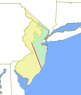
The Province of East Jersey, along with the Province of West Jersey, between 1674 and 1702 in accordance with the Quintipartite Deed, were two distinct political divisions of the Province of New Jersey, which became the U.S. state of New Jersey. The two provinces were amalgamated in 1702. East Jersey's capital was located at Perth Amboy. Determination of an exact location for a border between West Jersey and East Jersey was often a matter of dispute.

<span class="mw-page-title-main">George Keith (missionary)</span> Scottish religious leader

George Keith was a Scottish religious leader, a Presbyterian turned Quaker turned Anglican. He was born in Peterhead, Aberdeenshire, Scotland, to a Presbyterian family and received an M.A. from the University of Aberdeen. Keith joined the Religious Society of Friends (Quakers) in the 1660s, accompanying George Fox, William Penn, and Robert Barclay on a mission to the Netherlands and Germany in 1677.

<span class="mw-page-title-main">Province of New Jersey</span> British colony in North America (1663–1673, 1702–1776)

The Province of New Jersey was one of the Middle Colonies of Colonial America and became the U.S. state of New Jersey in 1776. The province had originally been settled by Europeans as part of New Netherland but came under English rule after the surrender of Fort Amsterdam in 1664, becoming a proprietary colony. The English renamed the province after the island of Jersey in the English Channel. The Dutch Republic reasserted control for a brief period in 1673–1674. After that it consisted of two political divisions, East Jersey and West Jersey, until they were united as a royal colony in 1702. The original boundaries of the province were slightly larger than the current state, extending into a part of the present state of New York, until the border was finalized in 1773.

<span class="mw-page-title-main">South Jersey</span> Geographic region of the U.S. state of New Jersey

South Jersey comprises the southern portion of the U.S. state of New Jersey. It is located between Pennsylvania and the lower Delaware River to its west, the Atlantic Ocean to its east, Delaware to its south, and Central Jersey to its north. South Jersey is geographically the southernmost region of the northeastern United States.

<span class="mw-page-title-main">Twelve-Mile Circle</span> Boundary between Pennsylvania and Delaware in the United States

The Twelve-Mile Circle is an approximately circular arc that forms most of the boundary between Delaware and Pennsylvania. It is a combination of different circular arcs that have been feathered together.

<span class="mw-page-title-main">New York–Pennsylvania border</span>

The New York–Pennsylvania border is the state line between the U.S. states of New York and Pennsylvania. It has three sections:

<span class="mw-page-title-main">Colonial history of New Jersey</span>

European colonization of New Jersey started soon after the 1609 exploration of its coast and bays by Henry Hudson. Dutch and Swedish colonists settled parts of the present-day state as New Netherland and New Sweden.

Daniel Coxe III was an English physician and governor of West Jersey from 1687 to 1688 and 1689 to 1692.

Gawen Lawrie was a deputy governor of the American province of East Jersey from 1683 to 1686.

<span class="mw-page-title-main">County Route 533 (New Jersey)</span> County highway in New Jersey, U.S.

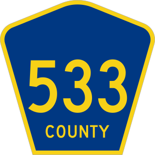
County Route 533 is a county highway in the U.S. state of New Jersey. The highway extends 32.78 miles (52.75 km) from the White Horse Circle, in Hamilton Township to Middlesex CR 607 on the border of Bound Brook and Middlesex Borough. CR 533 shares a long concurrency with U.S. Route 206 through Princeton and Montgomery Township, while portions of the roadway in Somerset County are part of the Millstone River Valley Scenic Byway.

Newton Township is a defunct township that was located in Sussex County, in northwestern New Jersey, in the United States. The township was established as a precinct in 1751, the township is first mentioned in a description of its boundaries in the sessions of the Court of Common Pleas in Morris County. Before the establishment of Sussex County on 8 June 1753, Morris County controlled the sparsely populated areas in the northwestern corner of New Jersey and spanned the territory of three present-day New Jersey counties: Morris, Sussex, and Warren. After ceding territory on several occasions new municipalities were created, Newton Township ceased to exist on 11 April 1864.

<span class="mw-page-title-main">New York – New Jersey Line War</span> 18th-century skirmishes on the New York–New Jersey border

The New York – New Jersey Line War was a series of skirmishes and raids that took place for over half a century between 1701 and 1765 at the disputed border between two American colonies, the Province of New York and the Province of New Jersey.

The history of Sussex County, New Jersey spans over 13,000 years from the time Paleo Indians arrived after the Wisconsin glacier melted to the present day, and the entire width of the American experience.

A tenth was used to divide the former American Province of West Jersey into smaller administrative divisions. Despite seemingly related names, tenths are not directly related to hundreds, other than both being administrative divisions.

<span class="mw-page-title-main">Penn–Calvert boundary dispute</span> Long-running legal conflict

The Penn–Calvert boundary dispute was a long-running legal conflict between William Penn and his heirs on one side, and Charles Calvert, 3rd Baron Baltimore and his heirs on the other side. The overlapping nature of their charters of land in Colonial America required numerous attempts at mediation, surveying, and intervention by the king and courts of England to ultimately be resolved. Subsequent questions over these charters have also been adjudicated by American arbitrators and the Supreme Court of the United States. The boundary dispute shaped the eventual borders of five U.S. states: Pennsylvania, Maryland, Delaware, New Jersey, and West Virginia.

Jacques Le Tort was a French-Canadian fur trapper, trader, explorer and entrepreneur who spent much of his life in the Province of Pennsylvania engaged in the fur trade. He collaborated with other French-Canadians living there at the time, including Peter Bisaillon and Martin Chartier, as well as the future mayor of Philadelphia, James Logan. By the late 1690s he had become wealthy and somewhat notorious; the Provincial authorities had his wife arrested on suspicion of conspiring with the French to take control of Pennsylvania territory, although no charges were ever proven. He disappeared following a trip to England in 1702 and is presumed to have died at sea. His wife Anne Le Tort and his son James Le Tort took over his business after his death.

References

  1. Snyder, John Parr, The mapping of New Jersey; the men and their art, Rutgers University, (Rahway, NJ 1973).
  2. Leaming, Aaron and Spicer, Jacob. The Grants, Concessions and Original Constitutions of the Province of New-Jersey. (Philadelphia: W. Bradford, 1758), 10.
  3. 1 2 3 4 Snyder, John Parr. The Story of New Jersey's Civil Boundaries: 1606–1968. (Trenton, New Jersey: Bureau of Geology and Topography, 1969).
  4. "Straddling the Jerseys on Province Line Road".
  5. "7,000-population town epicenter of Giants-Eagles rivalry". New York Daily News. January 10, 2009. Retrieved July 30, 2013.
  6. Worlidge, John. A New Mapp of East and West New Jersey being an exact survey Taken by Mr John Worlidge. (London, c. 1696).
  7. Pomfret, John E. The Province of East New Jersey, 1609–1702. (Princeton, NJ: Princeton University Press, 1962), 277, 297–298. Whitehead, William. Documents Relating to the Colonial History of the State of New Jersey. Volume 2. (Newark, NJ: Daily Journal Establishment, 1880), 135–136.
  8. Aun, Fred. "A Fine Old Line Across New Jersey" in Coordinate (Journal of the New Jersey Society of Professional Land Surveyors) Spring 1993, Volume 15, No. 1. Retrieved 3 May 2013.