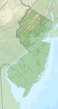
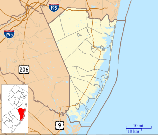
Atlantic County is a county located in the U.S. state of New Jersey. As of the 2010 United States Census, the county had a population of 274,549, having increased by 21,997 from the 252,552 counted at the 2000 Census, As of the 2020 Census Bureau estimate, the county's population was 262,945, making it the 15th-largest of the state's 21 counties. Its county seat is the Mays Landing section of Hamilton Township. The most populous place was Egg Harbor Township, with 43,323 residents at the time of the 2010 Census; Galloway Township, covered 115.21 square miles (298.4 km2), the largest total area of any municipality, though Hamilton Township has the largest land area, covering 111.13 square miles (287.8 km2).

Egg Harbor Township is a township in Atlantic County, New Jersey, United States. As of the 2010 United States Census, the township's population was 43,323, reflecting an increase of 12,597 (+41.0%) from the 30,726 counted in the 2000 Census, which had in turn increased by 6,182 (+25.2%) from the 24,544 counted in the 1990 Census.
Egg Harbor City is a city in Atlantic County, New Jersey, United States. As of the 2010 United States Census, the city's population was 4,243, reflecting a decline of 302 (-6.6%) from the 4,545 counted in the 2000 Census, which had in turn declined by 38 (-0.8%) from the 4,583 counted in the 1990 Census.
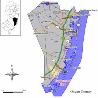
Eagleswood Township is a township in Ocean County, New Jersey, United States. As of the 2010 United States Census, the township's population was 1,603, reflecting an increase of 162 (+11.2%) from the 1,441 counted in the 2000 Census, which had in turn declined by 35 (-2.4%) from the 1,476 counted in the 1990 Census. The 2010 population was the highest recorded in any decennial census.
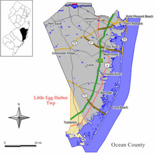
Little Egg Harbor Township is a township in Ocean County, New Jersey, United States. As of the 2010 United States Census, the township's population was 20,065, reflecting an increase of 4,120 (+25.8%) from the 15,945 counted in the 2000 Census, which had in turn increased by 2,612 (+19.6%) from the 13,333 counted in the 1990 Census. The 2010 population was the highest recorded in any decennial census.

Jamaica Bay Wildlife Refuge is a wildlife refuge in New York City managed by the National Park Service as part of Gateway National Recreation Area. It is composed of the open water and intertidal salt marshes of Jamaica Bay. It lies entirely within the boundaries of New York City, divided between the boroughs of Brooklyn to the west and Queens to the east.

The New York–New Jersey Harbor Estuary, also known as the Hudson-Raritan Estuary, is in the northeastern states of New Jersey and New York on the East Coast of the United States. The system of waterways of the Port of New York and New Jersey forms one of the most intricate natural harbors in the world and one of the busiest ports of the United States. The harbor opens onto the New York Bight in the Atlantic Ocean to the southeast and Long Island Sound to the northeast.

Cape May is a peninsula and island ; the southern tip of the island is the southernmost point of the U.S. state of New Jersey. The peninsula resides in Cape May County and runs southwards from the New Jersey mainland, separating Delaware Bay from the Atlantic Ocean. The cape is named for Cornelius Jacobsen Mey, a Dutch explorer who worked for the Dutch East India Company.

Barnegat Bay is a small brackish arm of the Atlantic Ocean, approximately 42 miles (68 km) long, along the coast of Ocean County, New Jersey in the United States. It is separated from the Atlantic by the long Barnegat Peninsula, as well as by the north end of Long Beach Island, popular segments of the Jersey Shore. The bay is fed by several small rivers, including the Toms River and Metedeconk River, which empty into the bay through small estuaries along its inner shore. The communities of Toms River, Silverton, and Forked River sit along the river estuaries on the bay.

The Mullica River is a 50.6-mile-long (81.4 km) river in southern New Jersey in the United States. The Mullica was once known as the Little Egg Harbor River.

Ong's Hat is a ghost town in Pemberton Township, Burlington County, New Jersey, United States. It is located on Magnolia Road west of the Four Mile Circle, where New Jersey Route 72 intersects with New Jersey Route 70. It is the northern terminus of the Batona Trail.

North American telephone area code 920 covers much of eastern Wisconsin. It was created on July 26, 1997, in a split from area code 414. 414 formerly covered the entire eastern third of the state. 920 will eventually be overlaid with area code 274, but 920 is not predicted to be exhausted until 2028.

The Edwin B. Forsythe National Wildlife Refuge is a United States National Wildlife Refuge located in southern New Jersey along the Atlantic coast north of Atlantic City, in Atlantic and Ocean counties. The refuge was created in 1984 out of two existing refuge parcels created to protect tidal wetland and shallow bay habitat for migratory water birds. The Barnegat Division is located in Ocean County on the inland side of Barnegat Bay. The Brigantine Division is located approximately 10 miles (16 km) north of Atlantic City along the south bank of the mouth of the Mullica River. The two divisions are separated by approximately 20 miles (32 km). The refuge is located along most active flight paths of the Atlantic Flyway, making it an important link in the network of national wildlife refuges administered nationwide by the U.S. Fish and Wildlife Service. Forsythe Refuge is a part of the Hudson River/New York Bight Ecosystem and The New Jersey Coastal Heritage Trail Route. The refuge is named for Edwin B. Forsythe, conservationist Congressman from New Jersey.

Humboldt Bay is a natural bay and a multi-basin, bar-built coastal lagoon located on the rugged North Coast of California, entirely within Humboldt County, United States. It is the largest protected body of water on the West Coast between San Francisco Bay and Puget Sound, the second-largest enclosed bay in California, and the largest port between San Francisco and Coos Bay, Oregon. The largest city adjoining the bay is Eureka, the regional center and county seat of Humboldt County, followed by the city of Arcata. These primary cities, together with adjoining unincorporated communities and several small towns, comprise a Humboldt Bay Area total population of nearly 80,000 people. This comprises nearly 60% of the population of Humboldt County. The bay is home to more than 100 plant species, 300 invertebrate species, 100 fish species, and 200 bird species. In addition, the bay and its complex system of marshes and grasses support hundreds of thousands of migrating and local shore birds. Commercially, this second-largest estuary in California is the site of the largest oyster production operations on the West Coast, producing more than half of all oysters farmed in California.

Absecon Island is a barrier island located on the Jersey Shore of the Atlantic Ocean in Atlantic County, New Jersey, United States. On the island are the resort communities of Atlantic City, Ventnor, Margate, and Longport. The island ends at Absecon Inlet to the north and Great Egg Harbor Inlet to the south.
West Creek is an unincorporated community and hamlet located within Eagleswood Township in Ocean County, New Jersey, United States.

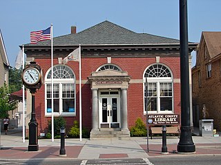
Capt. John Jeffries Burial Marker is an historic burial monument in the cemetery at Scullville Bible Church in Egg Harbor Township, New Jersey, along County Route 559 near Somers Point. It was built in 1887 and added to both the New Jersey Register of Historic Places and the National Register of Historic Places in 1984.
Great Egg Harbor Bay is a bay between Atlantic and Cape May counties along the southern New Jersey coast. The name derives from Dutch explorer Cornelius Jacobsen May's description of the plentiful birds laying eggs, naming the waters Eyren Haven, which translates to Egg Harbor in English. The bay has a total area of 8.5 sq mi (22 km2). Its depth ranges from shallow waters in the southern extension, called Peck Bay, to a 33 ft (10 m) deep channel.

Climate change in New Jersey is of concern due to its effects on the ecosystem, economy, infrastructure, and people of New Jersey.