Crosswicks, New Jersey

Last updated

Crosswicks, New Jersey
8 Church Street view, Crosswicks, NJ.jpg
The J. Ivins House on Church Street, part of the Crosswicks Historic District
Location map of Burlington County, New Jersey.svg
Red pog.svg
Crosswicks
Location of Crosswicks in Burlington County (Inset: Location of county within the state of New Jersey)
USA New Jersey location map.svg
Red pog.svg
Crosswicks
Crosswicks (New Jersey)
Usa edcp location map.svg
Red pog.svg
Crosswicks
Crosswicks (the United States)
Coordinates: 40°09′12″N74°38′52″W / 40.15333°N 74.64778°W / 40.15333; -74.64778
Country Flag of the United States.svg  United States
State Flag of New Jersey.svg  New Jersey
County Burlington
Township Chesterfield
Area
[1]
  Total1.84 sq mi (4.78 km2)
  Land1.82 sq mi (4.73 km2)
  Water0.02 sq mi (0.05 km2)
Elevation
[2]
82 ft (25 m)
Population
 (2020) [3]
  Total849
  Density465.21/sq mi (179.63/km2)
Time zone UTC−05:00 (Eastern (EST))
  Summer (DST) UTC−04:00 (EDT)
Area code(s) 609, 640
FIPS code 34-16060 [4]
GNIS feature ID875749 [2]

Crosswicks is an unincorporated community and census-designated place (CDP) [5] located along the Crosswicks Creek in the northern part of Chesterfield Township in Burlington County in the U.S. state of New Jersey. [6] [7] The area is served as United States Postal Service ZIP Code 08515.

Contents

As of the 2000 United States census, the population for ZIP Code Tabulation Area 08515 was 290.

History

Chesterfield Township comprises three distinct communities: Chesterfield, Crosswicks and Sykesville. The area was first settled in 1677, when a group primarily consisting of Quakers settled in the area of Crosswicks, the oldest of the Chesterfield's three villages. [8] Its name derives from the Lenape language word "Crossweeksung", meaning "house of separation". [9]

On June 23, 1778, during the American Revolutionary War, the Battle of Crosswicks was fought here over the bridge crossing the Crosswicks Creek. Philemon Dickinson, brigadier general in the New Jersey militia, and William Maxwell, brigadier general in the Continental Army, delayed the march of British troops led by General Henry Clinton, preceding the Battle of Monmouth on June 28. [10]

Crosswicks is home to a Friends Meeting House, as well as a historic library which used to house the Crosswicks Fire Department. The fire department's current home is in the former schoolhouse on New Street, which it has occupied since 1968. The building was completed in 1909. The current engine bay (where trucks are kept) was built in 1914, although the original 1909 cornerstone lies in the new section (it was moved).

The Crosswicks Community Association holds an annual family-style croquet tournament and music festival on the village green in July. There is live music provided by local bands during the day. Food is available from vendors. There are lawn games set up for children.

Historic district

Crosswicks Historic District
J. M. Bunting House, Crosswicks, NJ.jpg
J. M. Bunting House, built c.1858
LocationChesterfield-Crosswicks Road, Main, Church and Front Streets
Area50 acres (20 ha)
Architectural styleGreek Revival, Gothic, Provincial Georgian
NRHP reference No. 76001146 [11]
NJRHP No.777 [12]
Significant dates
Added to NRHPMay 3, 1976
Designated NJRHPOctober 23, 1975

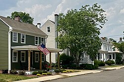
The Crosswicks Historic District is a 50-acre (20 ha) historic district encompassing the area along County Route 660 (Chesterfield-Crosswicks Road, Main Street), Church and Front Streets in the community. It was added to the National Register of Historic Places on May 3, 1976, for its significance in architecture, military history, religion, and transportation. The district has 95 contributing buildings, including the Crosswicks Friends Meeting House. [13] The meeting house, historically known as the Chesterfield Friends Meeting House, was documented by the Historic American Buildings Survey (HABS) in 1936. [14] Chesterfield Friends Meeting, now known as Crosswicks Friends Meeting, was founded in 1684. [15] The first meeting house was built here in 1692. It was the replaced by a larger brick building in 1706. The third and current one is a 2+12-story brick building from 1773 featuring Provincial Georgian architectural style. Next to it is the Friends First Day School with the same style. The J. M. Bunting House is a three-story building featuring Italianate architecture. The public library building was formerly a firehouse. [13]

Geography

The community has an area of 51.98 square kilometres (20.07 sq mi) and is located on the bank of Crosswicks Creek, a tributary of the Delaware River. The community is located 9.1 kilometres (5.7 mi) from Trenton, the capital of the U.S state of New Jersey and 27 kilometres (17 mi) from Philadelphia.

Demographics

As of the 2020 United States census, the population was 849. [3]

Historical population
CensusPop.Note
2020 849
U.S. Decennial Census [16]
2020 [3]

See also

Related Research Articles

<span class="mw-page-title-main">Bordentown, New Jersey</span> City in Burlington County, New Jersey, United States

Bordentown is a city in Burlington County, in the U.S. state of New Jersey. As of the 2020 United States census, the city's population was 3,993, an increase of 69 (+1.8%) from the 2010 census count of 3,924, which in turn reflected a decline of 45 (−1.1%) from the 3,969 counted in the 2000 census.

<span class="mw-page-title-main">Chesterfield Township, New Jersey</span> Township in Burlington County, New Jersey, United States

Chesterfield Township is a township in Burlington County, in the U.S. state of New Jersey. As of the 2020 United States census, the township's population was 9,422, an increase of 1,723 (+22.4%) from the 2010 census count of 7,699, which in turn reflected an increase of 1,744 (+29.3%) from the 5,955 counted in the 2000 census. The township, and all of Burlington County, is a part of the Philadelphia-Reading-Camden combined statistical area and the Delaware Valley.

<span class="mw-page-title-main">Lumberton, New Jersey</span> Township in Burlington County, New Jersey, United States

Lumberton is a township in Burlington County, in the U.S. state of New Jersey. The township, and all of Burlington County, is a part of the Philadelphia-Reading-Camden combined statistical area and the Delaware Valley. As of the 2020 United States census, the township's population was 12,803, an increase of 244 (+1.9%) from the 2010 census count of 12,559, which in turn reflected an increase of 2,098 (+20.1%) from the 10,461 counted in the 2000 census.

<span class="mw-page-title-main">Mount Holly, New Jersey</span> Township in Burlington County, New Jersey, United States

Mount Holly is a township that is the county seat of Burlington County in the U.S. state of New Jersey. It is an eastern suburb of Philadelphia, the nation's sixth largest city as of 2020. As of the 2020 United States census, the township's population was 9,981, an increase of 445 (+4.7%) from the 2010 census count of 9,536, which in turn reflected a decline of 1,192 (-11.1%) from the 10,728 counted in the 2000 census. The township, and all of Burlington County, is a part of the Philadelphia-Reading-Camden combined statistical area and the Delaware Valley.

<span class="mw-page-title-main">New Hanover Township, New Jersey</span> Township in Burlington County, New Jersey, United States

New Hanover Township is a township in Burlington County, in the U.S. state of New Jersey. As of the 2020 United States census, the township's population was 6,367, a decrease of 1,018 (−13.8%) from the 2010 census count of 7,385, which in turn reflected decline of 2,359 (−24.2%) from the 9,744 counted in the 2000 census. The township, and all of Burlington County, is a part of the Philadelphia-Reading-Camden combined statistical area and the Delaware Valley.

<span class="mw-page-title-main">Pemberton, New Jersey</span> Borough in Burlington County, New Jersey, United States

Pemberton is a borough in Burlington County, in the U.S. state of New Jersey. As of the 2020 United States census, the borough's population was 1,371, a decrease of 38 (−2.7%) from the 2010 census count of 1,409, which in turn reflected an increase of 199 (+16.4%) from the 1,210 counted in the 2000 census. The township, and all of Burlington County, is a part of the Philadelphia–Reading–Camden combined statistical area and the Delaware Valley.

<span class="mw-page-title-main">Riverton, New Jersey</span> Borough in Burlington County, New Jersey, United States

Riverton is a borough located in Burlington County, in the U.S. state of New Jersey. As of the 2020 United States census, the borough's population was 2,764, a decrease of 15 (−.5%) from the 2010 census count of 2,779, which in turn reflected an increase of 20 (+0.7%) from the 2,759 counted in the 2000 census. The borough, and all of Burlington County, is a part of the Philadelphia-Reading-Camden combined statistical area and the Delaware Valley.

<span class="mw-page-title-main">Southampton Township, New Jersey</span> Township in Burlington County, New Jersey, United States

Southampton Township is a township in Burlington County, in the U.S. state of New Jersey. As of the 2020 United States census, the township's population was 10,317, a decrease of 147 (−1.4%) from the 10,464 recorded at the 2010 census, which in turn had reflected an increase of 76 (+0.7%) from the 10,388 counted at the 2000 census. The township, and all of Burlington County, is a part of the Philadelphia-Reading-Camden combined statistical area and the Delaware Valley.

<span class="mw-page-title-main">Springfield Township, Burlington County, New Jersey</span> Township in Burlington County, New Jersey, United States

Springfield Township is a township in Burlington County, in the U.S. state of New Jersey. As of the 2020 United States census, the township's population was 3,245, a decrease of 169 (−5.0%) from the 2010 census count of 3,414, which in turn reflected an increase of 187 (+5.8%) from the 3,227 counted in the 2000 census. The township, and all of Burlington County, is a part of the Philadelphia-Reading-Camden combined statistical area and the Delaware Valley.

<span class="mw-page-title-main">Bordentown Township, New Jersey</span> Township in Burlington County, New Jersey, United States

Bordentown Township is a township in Burlington County, in the U.S. state of New Jersey. As of the 2020 United States census, the township's population was 11,791, an increase of 424 (+3.7%) from the 2010 census count of 11,367, which in turn reflected an increase of 2,987 (+35.6%) from the 8,380 counted in the 2000 census. The township, and all of Burlington County, is a part of the Philadelphia-Reading-Camden combined statistical area and the Delaware Valley.

<span class="mw-page-title-main">New Vernon, New Jersey</span> Place in Morris County, New Jersey, United States

New Vernon is an unincorporated community and census-designated place located within Harding Township in Morris County, in the U.S. state of New Jersey. The community falls within the boundaries of Harding Township along with a portion of Green Village. New Vernon is the location of the governmental offices for Harding Township.

<span class="mw-page-title-main">Quakertown, New Jersey</span> Populated place in Hunterdon County, New Jersey, US

Quakertown is an unincorporated community located within Franklin Township in Hunterdon County, New Jersey. It was once known as Fairview. The area was settled by Quakers from Burlington County, who organized a meeting house here in 1733. The Quakertown Historic District was listed on the state and national registers of historic places in 1990.

<span class="mw-page-title-main">Johnsonburg, New Jersey</span> Populated place in Warren County, New Jersey, US

Johnsonburg is an unincorporated community and census-designated place (CDP) located within Frelinghuysen Township in Warren County, in the U.S. state of New Jersey, that was created as part of the 2010 United States Census. As of the 2020 Census, the CDP's population was 381, up from 101 in the 2010 Census.

<span class="mw-page-title-main">Pottersville, New Jersey</span> Populated place in Hunterdon and Somerset counties, New Jersey, US

Pottersville is an unincorporated community and census-designated place (CDP) split between Bedminster Township in Somerset County and Tewksbury Township in Hunterdon County, in the U.S. state of New Jersey. The area is served as United States Postal Service ZIP Code 07979. As of the 2010 United States Census, the population for ZIP Code Tabulation Area 07979 was 589. In 1990, most of the village was listed on the National Register of Historic Places as the Pottersville Village Historic District.

<span class="mw-page-title-main">Roebling, New Jersey</span> Populated place in Burlington County, New Jersey, US

Roebling is an unincorporated community and census-designated place (CDP) located within Florence Township, in Burlington County, in the U.S. state of New Jersey, that was established as part of the 2010 United States census. As of the 2000 United States census, the CDP was combined as Florence-Roebling, which had a total population of 8,200. As of the 2010 Census, the Florence-Roebling CDP was split into its components, Florence and Roebling. As of the 2010 Census, the population of the Florence CDP was 4,426.

<span class="mw-page-title-main">Millington, New Jersey</span> Place in Morris County, New Jersey, United States

Millington is an unincorporated community and census-designated place (CDP) located within Long Hill Township in Morris County, in the U.S. state of New Jersey.

<span class="mw-page-title-main">Mauricetown, New Jersey</span> Populated place in Cumberland County, New Jersey, US

Mauricetown is a census-designated place and unincorporated community that is part of Commercial Township in Cumberland County, in the U.S. state of New Jersey.

<span class="mw-page-title-main">Vincentown, New Jersey</span> Place in Burlington County, New Jersey, United States

Vincentown is an unincorporated community and census-designated place (CDP) located on the South Branch Rancocas Creek in Southampton Township of Burlington County, New Jersey. The area is served as United States Postal Service ZIP Code 08088.

<span class="mw-page-title-main">Brookside, New Jersey</span> Place in Morris County, New Jersey, United States

Brookside is a historic unincorporated community and census-designated place (CDP) located within Mendham Township in Morris County, in the U.S. state of New Jersey. It is located approximately 6 mi (9.7 km) west of Morristown. It is close to the Washington Valley Historic District in neighboring Morris Township.

<span class="mw-page-title-main">Rancocas, New Jersey</span> Populated place in Burlington County, New Jersey, US

Rancocas is an unincorporated community located within Westampton Township in Burlington County, New Jersey. The name derives from the Native American word Rankokous, which was used in the name of the Powhatan Lenape Nation Indian Reservation located in Westampton Township. The name was also known as a sub-tribe of the Ancocus. The Reservation was a popular tourist destination for visitors from the Philadelphia area, New York, and local residents, before the Reservation became Rancocas State Park.

References

  1. "ArcGIS REST Services Directory". United States Census Bureau. Retrieved October 11, 2022.
  2. 1 2 "Crosswicks". Geographic Names Information System . United States Geological Survey, United States Department of the Interior. Variant name: Crossweeksung
  3. 1 2 3 Census Data Explorer: Crosswicks CDP, New Jersey, United States Census Bureau. Accessed June 15, 2023.
  4. Geographic Codes Lookup for New Jersey, Missouri Census Data Center. Accessed June 9, 2023.
  5. State of New Jersey Census Designated Places - BVP20 - Data as of January 1, 2020, United States Census Bureau. Accessed December 1, 2022.
  6. Genovese, Peter (September 27, 2019). "N.J.'s 33 best small towns, ranked, for the ultimate fall day trip". NJ.com. Retrieved February 18, 2020.
  7. Locality Search, State of New Jersey. Accessed March 15, 2015.
  8. History of Chesterfield Township, Chesterfield Township. Accessed March 6, 2007. Archived October 11, 2007, at the Wayback Machine
  9. Hutchinson, Viola L. (May 1945). The Origin of New Jersey Place Names (PDF). New Jersey Public Library Commission. p. 11.
  10. Zimmerman, Colin (August 4, 2022). "The Battle of Crosswicks: Prelude to Monmouth".
  11. "National Register Information System  (#76001146)". National Register of Historic Places . National Park Service. November 2, 2013.
  12. "New Jersey and National Registers of Historic Places – Burlington County" (PDF). New Jersey Department of Environmental Protection – Historic Preservation Office. September 29, 2022. p. 5. listed as the Crosswicks Historic District
  13. 1 2 Dr. and Mrs. John J. Winters, Jr. (October 1975). "National Register of Historic Places Inventory/Nomination: Crosswicks". National Park Service. With accompanying 31 photos
  14. "Chesterfield Friends Meeting House". Historic American Buildings Survey. 1936.
  15. "A Brief History of the Crosswicks Friends Meeting". Crosswicks Friends Meeting.
  16. "Census of Population and Housing". Census.gov. Retrieved June 4, 2016.