
McGuire AFB/McGuire, the common name of the McGuire unit of Joint Base McGuire-Dix-Lakehurst, is a United States Air Force base in Burlington County, New Jersey, United States, approximately 16.1 miles (25.9 km) south-southeast of Trenton. McGuire is under the jurisdiction of the Air Mobility Command. It was consolidated with two adjoining US Army and Navy facilities to become part of Joint Base McGuire-Dix-Lakehurst on 1 October 2009. The McGuire Air Force Base census-designated place (CDP) is located in portions of both New Hanover Township and North Hanover Township.

New Hanover Township is a township in Burlington County, New Jersey, United States. As of the 2010 United States Census, the township's population was 7,385, reflecting a decline of 2,359 (-24.2%) from the 9,744 counted in the 2000 Census, which had in turn increased by 198 (+2.1%) from the 9,546 counted in the 1990 Census. The township is located in the Delaware Valley.

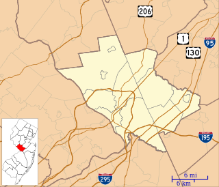
North Hanover Township is a township in Burlington County, New Jersey, United States. As of the 2010 United States Census, the township's population was 7,678, reflecting an increase of 331 (+4.5%) from the 7,347 counted in the 2000 Census, which had in turn declined by 2,647 (-26.5%) from the 9,994 counted in the 1990 Census.

Ewing Township is a township in Mercer County, New Jersey, United States. The township is within the New York metropolitan area as defined by the United States Census Bureau. It also directly borders the Philadelphia metropolitan area and is part of the Federal Communications Commission's Philadelphia Designated Market Area. As of the 2010 United States Census, the township's population was 35,790, reflecting an increase of 83 (+0.2%) from the 35,707 counted in the 2000 Census, which had increased by 1,522 (+4.5%) from the 34,185 counted in the 1990 Census.
East Hanover Township is a township in Morris County, New Jersey, United States. As of the 2010 United States Census, the township's population was 11,157, reflecting a decline of 236 (-2.1%) from the 11,393 counted in the 2000 Census, which had in turn increased by 1,467 (+14.8%) from the 9,926 counted in the 1990 Census.
Hanover Township is a township in Morris County, New Jersey, United States. At the 2010 United States Census, the township's population was 13,712, reflecting an increase of 814 (+6.3%) from the 12,898 counted in the 2000 Census, which had in turn increased by 1,360 (+11.8%) from the 11,538 counted in the 1990 Census. The township comprises the unincorporated communities of Whippany and Cedar Knolls.
Marlboro is an unincorporated community located within Marlboro Township in Monmouth County, New Jersey, United States.
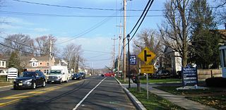
County Route 545 is a county highway in the U.S. state of New Jersey. The highway extends 14.76 miles (23.75 km) from Lakehurst Road in Pemberton Township to West Park Street in Bordentown. There is a 3.38-mile (5.44 km) stretch from Pemberton Boulevard at the Pemberton Township/New Hanover border to Rexall Avenue in Wrightstown that is permanently closed to the general public because of security restrictions on the Fort Dix entity of Joint Base McGuire–Dix–Lakehurst.
Pennsylvania Route 663 (PA 663) is a 22.13-mile-long (35.61 km) state highway in Montgomery and Bucks counties in southeast Pennsylvania. Its southern terminus is at PA 100 in the borough of Pottstown and its northern terminus is at PA 309 and PA 313 in the borough of Quakertown, where the road continues eastward as PA 313. Along the way, PA 663 also passes through the borough of Pennsburg. It is called John Fries Highway between Pennsburg and Quakertown. It has an interchange with Interstate 476 at exit 44 west of Quakertown. The route was assigned in 1930, and it has had several realignments since its commissioning, including two major ones.
The North Hanover Township School District is a comprehensive community public school district which serves children in pre-Kindergarten through sixth grades from North Hanover Township and from the McGuire Air Force Base unit of Joint Base McGuire-Dix-Lakehurst, in Burlington County, New Jersey, United States. The district operates three elementary schools, with two located in Jacobstown and one on the grounds of Joint Base MDL. It is the largest K-6 school district in Burlington County.

East Trenton is a neighborhood located within the city of Trenton in Mercer County, New Jersey, United States. It borders Hamilton Township and is home to a sizable African-American community, besides having small pockets of Latinos and Italians.
County Route 528 is a county highway in the U.S. state of New Jersey. The highway is designated 39.89 miles (64.20 km) from Farnsworth Avenue in Bordentown to Ocean Avenue in Mantoloking. The eastern end of the highway sustained extensive damage in 2012 when an inlet opened between Barnegat Bay and the Atlantic Ocean during Hurricane Sandy, scouring away the road east of the Mantoloking Bridge. The bridge and Route 35 intersection fully reopened in February 2013.
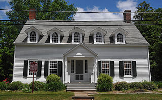
Joseph Emley Borden, aka Joe Josephs,, nicknamed "Josephus the Phenomenal", was a starting pitcher in professional baseball for two seasons. Born in the Jacobstown section of North Hanover Township, New Jersey, he was playing for a Philadelphia amateur team when he was discovered by the Philadelphia White Stockings of the National Association (NA) in 1875. The White Stockings needed a replacement for a recently released pitcher, and were awaiting the arrival of a replacement. During his short, seven-game stint with the team, he posted a 2–4 win–loss record, both victories recorded as shutouts. On July 28 of that season, he threw what is thought to be the first no-hitter in professional baseball history.
Pennsylvania Route 94 is a 30-mile (48 km) long north–south state highway located in southern Pennsylvania. The southern terminus of the route is at the Mason–Dixon line, where PA 94 continues into Maryland as Maryland Route 30. The northern terminus is at PA 34 south of Mount Holly Springs. PA 94 heads north-northwest from the state line through southwestern York County, where it passes through Hanover and intersects PA 116/PA 194 in the center of town. Past Hanover, the route heads into rural areas and crosses into the eastern portion of Adams County. Here, PA 94 intersects U.S. Route 30 east of New Oxford, PA 394 in Hampton, PA 234 north of Hampton, and US 15 in York Springs. The route heads into Cumberland County and crosses South Mountain, reaching its end at PA 34. PA 94 is designated as the 94th Infantry Division Memorial Highway for its entire length.
North Crosswicks is an unincorporated community located within Hamilton Township in Mercer County, New Jersey, United States. Residential homes, a cemetery, and farmland make up the area around North Crosswicks. Located across the Crosswicks Creek from the Chesterfield Township settlement of Crosswicks, a covered bridge formerly connected the two localities.

Hanover/Academy is a neighborhood located within the city of Trenton in Mercer County, New Jersey, United States. It is considered to be part of Downtown Trenton.

Nesco is an unincorporated community in Mullica Township, Atlantic County, New Jersey, United States.

Freewood Acres is an unincorporated community located within Howell Township in Monmouth County, New Jersey, United States. The area is made up of mostly single-story homes arranged along a street grid in the northern reaches of the Pine Barrens. U.S. Route 9 runs through the center of the community just north of its interchange with Interstate 195. The Land O'Pines Elementary School and Manasquan Reservoir County Park exist to the east of the community. It became the center of the Kalmyk American community in the latter part of the 20th century.

Ellisdale is an unincorporated community located along the border of North Hanover Township in Burlington County and Upper Freehold Township in Monmouth County, in New Jersey, United States. The community is centered about the intersection of Province Line Road and Hill Road / Ellisdale-Crosswicks Road. The Crosswicks Creek runs to the north of the settlement and the nearby Ellisdale Fossil Site takes its name from Ellisdale.


