Papakating Creek is a 20.1-mile-long (32.3 km) tributary of the Wallkill River located in Frankford and Wantage townships in Sussex County, New Jersey in the United States. The creek rises in a small swamp located beneath the eastern face of Kittatinny Mountain in Frankford and its waters join the Wallkill to the east of Sussex borough.

Raven Rock is an unincorporated community and hamlet along the Delaware River approximately three miles (4.8 km) north of Stockton along New Jersey Route 29. The hamlet was known earlier as Saxtonville. It is located within Delaware Township in Hunterdon County, in the U.S. state of New Jersey. It is the site of Bull's Island Recreation Area. The rock outcrop for which it is named is the southwest corner of the Hunterdon Plateau.

Hedding is an unincorporated community located within Mansfield Township, in Burlington County, in the U.S. state of New Jersey. From 1793–1813, the area was known as Bryant's Tavern after William Byrant of Brian the proprietor. In 1817, the name was changed to Three Tuns as a sign before the hostelry depicted three casks or tuns. In 1847, a church was built which was named Hedding Methodist Episcopal Church in honor of Elijah Hedding, a Bishop of this denomination. Three Tuns remained as the name of the area until 1920 when it was changed to Hedding, named after the church. The community itself is made up of single-family houses clustered around the main intersection in the settlement, Old York Road and Kinkora Road / Columbus Hedding Road ; the remainder of the area consists of farmland. Interstate 295 runs southeast of the community but no interchanges provide direct access to it.
Fostertown is an unincorporated community located within Lumberton Township in Burlington County, in the U.S. state of New Jersey. The site was founded in 1735 by William Foster, who established a plantation on modern-day West Bella Bridge Road. The area is largely farmland with some houses and a high-voltage power line dotting the landscape.

Jackson Mills is an unincorporated community located within Jackson Township, in Ocean County, in the U.S. state of New Jersey. Jackson Mills is located near exit 22 on Interstate 195. It is also located nearby County Route 526 and Jackson Mills Lake. The site was originally home to a sawmill owned by William Jackson. Today surrounding the lake are some houses and townhomes, small businesses, and the Jackson Township Veterans Memorial Garden, though this area of the township is more rural than other more suburbanized portions of it due to the higher density of forest.

Chairville is a rural unincorporated community located along the border of Medford and Southampton townships in Burlington County, in the U.S. state of New Jersey. The settlement is named for a chair parts factory that operated from 1845 to 1890. Also located in the area were the Peacock Cemetery, a sawmill, and a one-room schoolhouse. Today, the site is located at the intersection of Chairville Road and New Jersey Route 70 and Little Creek.
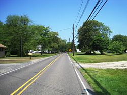
Buddtown is an unincorporated community located within Southampton Township in Burlington County, in the U.S. state of New Jersey. Located between Vincentown and Pemberton, it is named for Thomas Budd who owned farmland in the area in the 18th century. The area itself contains houses and churches in the community itself and farmland surrounding the settlement. The stream that runs through Buddtown is named Stop the Jade Run supposedly named for the cry made by the owners of a runaway horse, "jade" being an old name for a horse.

Burrs Mill is an unincorporated community located within Southampton Township in Burlington County, in the U.S. state of New Jersey. Found in a rural portion of the township near Route 70, it is located along its eponymous brook in a forested area within the Pine Barrens. A low density of houses surround nearby roads including Burrs Mill Road and Route 70's fire roads.

Chapel Hill is an unincorporated community located within Middletown Township, in Monmouth County, in the U.S. state of New Jersey. As its name implies, the area is on a high spot within the township between Fairview and Leonardo just south of the Naval Weapons Station Earle Waterfront Section. Unlike other areas of Middletown Township, the Chapel Hill section is not as developed with single-family homes; only a few housing developments are located off the area's main roads, Kings Highway and Chapel Hill Road. The rest of the area outside NWS Earle consists of horse farms and forestland.

Breton Woods is an unincorporated community located within Brick Township, in Ocean County, in the U.S. state of New Jersey. The community is located near the Metedeconk River and is bisected by Mantoloking Road. Except for commercial businesses located along Mantoloking Road, the area is made up of bungalows dotting the small roads throughout the area. A wood area of 31 acres near the community is known as Breton Woods. It was owned by the Archdiocese of Trenton, which had once intended or create a cemetery.

Brindletown is an unincorporated community located within Plumsted Township, in Ocean County, in the U.S. state of New Jersey. Brindletown was once a village home to a hotel, a mill, and large estates overlooking Brindle Lake. Brindletown was purchased by the federal government to expand Camp Dix in the 1920s. The site of the original Brindletown is within a weapons training site though the site of the current Brindletown is accessible to the public. The current settlement is centered about the intersection of Long Swamp Road and Carter Lane to the north of the original site. Houses line Long Swamp Road and other surrounding roads in the area while some farms are found to the north of Long Swamp Road. The portion of the community within the confines of Fort Dix is mostly forest.

Emleys Hill is an unincorporated community located within Upper Freehold Township in Monmouth County, in the U.S. state of New Jersey. The settlement is located at the intersection of Emleys Hill Road and Burlington Path Road.

Middlesex Downs is an unincorporated community located within Monroe Township in Middlesex County, in the U.S. state of New Jersey. The wholly residential settlement contains small homes along Dey Grove Road and Bergen Mills Road with larger homes in developments towards the south. The township-owned James Monroe Memorial Park is also located in this settlement. Much of the area to the north of Dey Grove Road consists of forest land but at one time this was planned to become a large planned community arranged in a street grid. The small property parcels and paper streets remain on township tax maps today.
Ardena is an unincorporated community located within Howell Township in Monmouth County, in the U.S. state of New Jersey. The community is located along County Route 524 near Vanderveer Road in the western part of the township. The area consists of about half farmland and half residential developments.

Burlington Heights is an unincorporated community located within Freehold Township in Monmouth County, in the U.S. state of New Jersey. The community was created in the early 1960s and originally consisted of 112 homes of mixed styles designed by Peter Petillo and Associates of Freehold. It is located along Colts Neck Road on the east side of the township, near New Jersey Route 18 and the Colts Neck municipal line.

Cooleys Corner is an unincorporated community located within Upper Freehold Township in Monmouth County, in the U.S. state of New Jersey. The site of the settlement is within the Assunpink Wildlife Management Area, a New Jersey Department of Environmental Protection Division of Fish and Wildlife-operated preserved area in Monmouth and Mercer counties along the Assunpink Creek. Before the creation of the Assunpink Lake in the 1970s, the area consisted of farmland located at the intersection of Clarksburg Road and Imlaystown-Hightstown Road. Some farmland is still present in the area but is now mostly used by hunters. The main boat ramp to Assunpink Lake is located along the former Imlaystown-Hightstown Road.

Ewansville or Ewanville is an unincorporated community located in Burlington County, in the U.S. state of New Jersey. The community is centered on the crossing of U.S. Route 206 (US 206) and the North Branch Rancocas Creek just north of the former Philadelphia and Long Branch Railway. Ewansville was the site of a station on the aforementioned railroad and was the terminus for a short spur track to Vincentown.

Beaverville is an unincorporated community located within Southampton Township in Burlington County, in the U.S. state of New Jersey. The area is composed of single-family homes, small businesses and warehouses, forest, and farmland. The community is located along Red Lion Road two miles (3.2 km) south of Vincentown, to the west of U.S. Route 206, and southeast of the Red Lion Airport. Originally, the settlement was the site of a one-room schoolhouse.

Comical Corner or Comical Corners is an unincorporated community located within Pemberton Township in Burlington County, in the U.S. state of New Jersey. The site of the actual corners is at the intersection of Pemberton Road and Arneys Mount Road. The original name may have been "Conical Corner" based on the cone-like shape of the skewed intersection but had turned to "Comical Corner" based on a mishearing. The area, located just to the north of Pemberton Borough, is mostly rural and is surrounded by farmland on the two obtuse sides of the intersection.

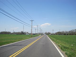
Davisville is an unincorporated community located within Chesterfield Township in Burlington County, in the U.S. state of New Jersey. The settlement, located at the intersection of County Route 528 and Chesterfield-Arneytown Road, is in a rural area in the eastern portion of the township. It consists mainly of farmland with some houses dotting the few roads that pass through the area.