Rancocas, New Jersey

Last updated
Rancocas, New Jersey
RANCOCAS HISTORIC VILLAGE.JPG
Rancocas Friends Meeting House
Location map of Burlington County, New Jersey.svg
Red pog.svg
Rancocas
USA New Jersey location map.svg
Red pog.svg
Rancocas
Usa edcp location map.svg
Red pog.svg
Rancocas
Coordinates: 40°00′38″N74°52′01″W / 40.01056°N 74.86694°W / 40.01056; -74.86694
Country Flag of the United States.svg  United States
State Flag of New Jersey.svg  New Jersey
County Burlington
Township Westampton
Elevation
18 m (59 ft)
Time zone UTC-5 (Eastern (EST))
  Summer (DST) UTC-4 (EDT)
Zip Code
08073
Area code(s) 609, 640
GNIS feature ID879606 [1]

Rancocas is an unincorporated community located within Westampton Township in Burlington County, New Jersey. [2] The name derives from the Native American[ clarification needed ] word Rankokous, which was used in the name of the Powhatan Lenape Nation Indian Reservation located in Westampton Township. The name was also known as a sub-tribe of the Ancocus. [3] The Reservation was a popular tourist destination for visitors from the Philadelphia area, New York, and local residents, before the Reservation became Rancocas State Park.

Contents

History

The village developed along the Mount HollyBeverly Turnpike. [4] In 1703, a Quaker meeting house, a log building, was erected in the community. [5]

Historic district

Rancocas Historic Village
LocationIrregular pattern bounded north and west by Willingboro border, east to Springside Road and south to 3rd Street
Area25 acres (10 ha)
NRHP reference No. 75001126 [6]
NJRHP No.880 [7]
Significant dates
Added to NRHPJune 5, 1975
Designated NJRHPSeptember 6, 1973

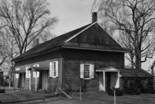
The Rancocas Historic Village, also known as the Rancocas Village Historic District, [7] is a historic district in Rancocas Village, bounded north and west by the Willingboro Township border, east to Springside Road and south to 3rd Street. It was added to the National Register of Historic Places on June 5, 1975 for its significance in architecture, commerce, and education. The district includes 46 contributing buildings. [4] The Quaker meeting house, a Friends meeting house, on Main Street was built in 1772 and features Flemish bond and patterned brick work. The nearby Friends school was built in 1822, also with brick. [4]

See also

Related Research Articles

<span class="mw-page-title-main">Eastampton Township, New Jersey</span> Township in Burlington County, New Jersey, United States

Eastampton Township is a township in Burlington County, in the U.S. state of New Jersey. As of the 2020 United States census, the township's population was 6,191, an increase of 122 (+2.0%) from the 2010 census count of 6,069, which in turn reflected a decline of 133 (−2.1%) from the 6,202 counted in the 2000 census. The township, and all of Burlington County, is a part of the Philadelphia-Reading-Camden combined statistical area and the Delaware Valley.

<span class="mw-page-title-main">Mount Holly, New Jersey</span> Township in Burlington County, New Jersey, United States

Mount Holly is a township that is the county seat of Burlington County in the U.S. state of New Jersey. It is an eastern suburb of Philadelphia, the nation's sixth largest city as of 2020. As of the 2020 United States census, the township's population was 9,981, an increase of 445 (+4.7%) from the 2010 census count of 9,536, which in turn reflected a decline of 1,192 (-11.1%) from the 10,728 counted in the 2000 census. The township, and all of Burlington County, is a part of the Philadelphia-Reading-Camden combined statistical area and the Delaware Valley.

<span class="mw-page-title-main">Westampton, New Jersey</span> Township in Burlington County, New Jersey, United States

Westampton is a township in Burlington County, in the U.S. state of New Jersey. As of the 2020 United States census, the township's population was 9,121, an increase of 308 (+3.5%) from the 2010 census count of 8,813, which in turn reflected an increase of 1,596 (+22.1%) from the 7,217 counted in the 2000 census. The township, and all of Burlington County, is a part of the Philadelphia-Reading-Camden combined statistical area and the Delaware Valley.

<span class="mw-page-title-main">Hainesport Township, New Jersey</span> Township in Burlington County, New Jersey, United States

Hainesport Township is a township in Burlington County, in the U.S. state of New Jersey. As of the 2020 United States census, the township's population was 6,035, a decline of 75 (-1.2%) from the 2010 census enumeration of 6,110, in turn reflecting an increase of 1,984 (+48.1%) from the 4,126 counted in the 2000 census. The township, and all of Burlington County, is a part of the Philadelphia-Reading-Camden combined statistical area and the Delaware Valley.

The Westampton Township Schools are a community public school district that serves students in pre-kindergarten through eighth grade from Westampton, in Burlington County, New Jersey, United States.

<span class="mw-page-title-main">Crosswicks, New Jersey</span> Populated place in Burlington County, New Jersey, US

Crosswicks is an unincorporated community and census-designated place (CDP) located along the Crosswicks Creek in the northern part of Chesterfield Township in Burlington County in the U.S. state of New Jersey. The area is served as United States Postal Service ZIP Code 08515.

<span class="mw-page-title-main">Vincentown, New Jersey</span> Place in Burlington County, New Jersey, United States

Vincentown is an unincorporated community and census-designated place (CDP) located on the South Branch Rancocas Creek in Southampton Township of Burlington County, New Jersey. The area is served as United States Postal Service ZIP Code 08088.

<span class="mw-page-title-main">Buckingham Friends Meeting House</span> Historic church in Pennsylvania, United States

The Buckingham Friends Meeting House is a historic Quaker meeting house at 5684 Lower York Road in Buckingham Township, Bucks County, Pennsylvania. Built in 1768 in a "doubled" style, it is nationally significant as a model for many subsequent Friends Meeting Houses. It was declared a National Historic Landmark in 2003.

<span class="mw-page-title-main">Arney's Mount Friends Meetinghouse and Burial Ground</span> Historic meetinghouse in New Jersey, United States

Arney's Mount Friends Meetinghouse and Burial Ground is a historic Quaker meeting house located at the intersection of Mount Holly-Juliustown and Pemberton-Arney's Mount Roads in Arney's Mount, Burlington County, New Jersey, United States.

<span class="mw-page-title-main">Evesham Friends Meeting House</span> Historic meetinghouse in New Jersey, United States

Evesham Friends Meeting House is a historic Quaker meeting house at Moorestown-Mt. Laurel and Hainesport-Mt. Laurel Roads in Mount Laurel, New Jersey.

<span class="mw-page-title-main">Little Egg Harbor Friends Meeting House</span> Historic meetinghouse in New Jersey, United States

The Little Egg Harbor Friends Meeting House is a historic Quaker meetinghouse located at 21 E. Main Street in the borough of Tuckerton in Ocean County, New Jersey, United States. The meetinghouse was built in 1863. It was documented by the Historic American Buildings Survey (HABS). The building was added to the National Register of Historic Places on December 9, 2002, for its significance in architecture and religion. Little Egg Harbor Meeting is part of Burlington Quarterly Meeting which is part of the Philadelphia Yearly Meeting. Friends continue to meet at Little Egg Harbor Meeting on Sundays at 10:30 a.m.

<span class="mw-page-title-main">Alloways Creek Friends Meetinghouse</span> Historic meetinghouse in New Jersey, United States

Alloways Creek Friends Meetinghouse is a historic Quaker meeting house on Buttonwood Avenue, 150 feet west of Main Street in the Hancock's Bridge section of Lower Alloways Creek Township in Salem County, New Jersey, United States. It was built in 1756 and documented by the Historic American Buildings Survey. It was later added to the National Register of Historic Places on December 18, 2003, for its significance in architecture.

<span class="mw-page-title-main">Bodo Otto House</span> Historic house in New Jersey, United States

The Bodo Otto House, also known as the Otto–Tonkin House, is a historic house located at the corner of County Route 551 and Quaker Road in the Mickleton section of East Greenwich Township in Gloucester County, New Jersey, United States. The house was built in 1766 and documented by the Historic American Buildings Survey (HABS) in 1936. It was added to the National Register of Historic Places on December 12, 1976, for its significance in military history.

<span class="mw-page-title-main">Thomas Maskel House</span> Historic house in New Jersey, United States

The Thomas Maskel House is located on Bacon's Neck Road near the Greenwich section of Greenwich Township in Cumberland County, New Jersey, United States. The building was documented by the Historic American Buildings Survey (HABS) in 1939. It was added to the National Register of Historic Places on June 10, 1975, for its significance in exploration/settlement.

<span class="mw-page-title-main">Greenwich Historic District</span> Historic district in New Jersey, United States

The Greenwich Historic District is a 350-acre (140 ha) historic district located in the Greenwich section of Greenwich Township in Cumberland County, New Jersey, United States. It extends from the Cohansey River north toward the neighboring settlement of Othello. The district was added to the National Register of Historic Places on January 20, 1972, for its significance in agriculture, architecture, commerce, and politics. It includes 19 contributing buildings, many documented by the Historic American Buildings Survey (HABS).

<span class="mw-page-title-main">Timbuctoo, New Jersey</span> Populated place in Burlington County, New Jersey, US

Timbuctoo is an unincorporated community in Westampton Township, Burlington County, New Jersey. Located along the Rancocas Creek, Timbuctoo was settled by formerly enslaved and free Black people, beginning in 1826. It includes Church St., Blue Jay Hill Road, and adjacent areas. At its peak in the mid-nineteenth century, Timbuctoo had more than 125 residents, a school, an AME Zion Church, and a cemetery. The key remaining evidence of this community is the cemetery on Church Street, which was formerly the site of Zion Wesleyan Methodist Episcopal African Church. Some current residents are descendants of early settlers.

<span class="mw-page-title-main">Arneytown, New Jersey</span> Unincorporated community in New Jersey, United States

Arneytown is an unincorporated community located along Province Line Road on the border of North Hanover Township in Burlington County and Upper Freehold Township in Monmouth County of New Jersey. It is two miles (3.2 km) north of Jacobstown. Province Line Road was on the boundary line between the Provinces of East Jersey and West Jersey. The area was once called Upper Freehold by 18th-century Quaker settlers. With the establishment of the first post office in 1827, it became known as Arneytown.

<span class="mw-page-title-main">Brainerd School</span> United States historic place

The Brainerd Schoolhouse is a one-room schoolhouse located at 35 Brainerd Street in Mount Holly Township, Burlington County, New Jersey, United States. Built in 1759, it is the oldest building of its type in the state and now a museum. Listed as the John Brainard School, it was documented by the Historic American Buildings Survey in 1936. Listed as the Old Schoolhouse, it was added to the National Register of Historic Places on November 26, 2008, for its significance in education. It is a contributing property to the Mount Holly Historic District. It is owned and operated by the National Society of the Colonial Dames of America.

<span class="mw-page-title-main">John Smith House (Washington Valley, New Jersey)</span> Historic house in New Jersey, United States

The John Smith House is a historic building located at 124 Washington Valley Road in the Washington Valley section of Morris Township, Morris County, New Jersey. The two-story brick house was built in 1812, with the year set in black brick on the west gable. It was added to the National Register of Historic Places on January 1, 1976, for its significance in agriculture and architecture. It is also a contributing property of the Washington Valley Historic District.

<span class="mw-page-title-main">Old Mine Road Historic District</span> Historic district in New Jersey, United States

The Old Mine Road Historic District is a 687-acre (278 ha) historic district located along Old Mine Road in Sussex County and Warren County, New Jersey. It is part of the Delaware Water Gap National Recreation Area. The district was added to the National Register of Historic Places on December 3, 1980, for its significance in agriculture, archaeology, architecture, commerce, exploration/settlement, and transportation. It includes 24 contributing buildings and five contributing sites.

References

  1. U.S. Geological Survey Geographic Names Information System: Rancocas, New Jersey
  2. Locality Search, State of New Jersey. Accessed June 9, 2016.
  3. Hutchinson, Viola L. The Origin of New Jersey Place Names, New Jersey Public Library Commission, May 1945. Accessed July 12, 2018.
  4. 1 2 3 Staff of Historic Sites Section (1975). "National Register of Historic Places Inventory/Nomination: Rancocas Historic Village". National Park Service. With accompanying 18 photos
  5. "West Jersey Quaker Meetings: Rancocas". West Jersey History Project.
  6. "National Register Information System  (#75001126)". National Register of Historic Places . National Park Service. November 2, 2013.
  7. 1 2 "New Jersey and National Registers of Historic Places – Burlington County" (PDF). New Jersey Department of Environmental Protection – Historic Preservation Office. May 21, 2018. p. 17.