Georgetown, New Jersey

Last updated

Georgetown, New Jersey
Georgetown, NJ.jpg
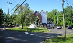
Center of Georgetown
Location map of Burlington County, New Jersey.svg
Red pog.svg
Georgetown
Location in Burlington County (Inset: Burlington County in New Jersey)
USA New Jersey location map.svg
Red pog.svg
Georgetown
Georgetown (New Jersey)
Usa edcp location map.svg
Red pog.svg
Georgetown
Georgetown (the United States)
Coordinates: 40°04′46″N74°39′12″W / 40.07944°N 74.65333°W / 40.07944; -74.65333
CountryFlag of the United States.svg  United States
StateFlag of New Jersey.svg  New Jersey
County Burlington
Township Mansfield
Named for George Sykes
Elevation
29 m (95 ft)
Time zone UTC−05:00 (Eastern (EST))
  Summer (DST) UTC−04:00 (Eastern (EDT))
Area code(s) 609, 640
GNIS feature ID876588 [1]

Georgetown is an unincorporated community located within Mansfield Township, Burlington County, in the U.S. state of New Jersey. [2] It was named for George Sykes, who served in the U.S. Congress. [3]

Transportation

County Route 537, County Route 545, and NJ Route 68 are major roads around Georgetown. The New Jersey Turnpike passes Georgetown to the northwest. The closest exit to Georgetown on the NJ Turnpike is exit 7 (U.S. 206Bordentown, Trenton).

Related Research Articles

<span class="mw-page-title-main">New Jersey Turnpike</span> Toll road in New Jersey

The New Jersey Turnpike (NJTP) is a system of controlled-access highways in the U.S. state of New Jersey. The turnpike is maintained by the New Jersey Turnpike Authority (NJTA). The 117.20-mile (188.62 km) mainline's southern terminus is at Interstate 295 (I-295) and U.S. Route 40 (US 40) in Pennsville Township in Salem County, near the Delaware Memorial Bridge. Its northern terminus is at the approach to the George Washington Bridge in Fort Lee in Bergen County; originally it was at an interchange with I-80 and US 46 in Ridgefield Park. Construction of the mainline from concept to completion took 22 months, from 1950 to 1951. It was opened to traffic on November 5, 1951, between its southern terminus and exit 10.

<span class="mw-page-title-main">Middlesex County, New Jersey</span> County in New Jersey, United States

Middlesex County is located in the north-central part of New Jersey, United States, extending inland from the Raritan Valley region to the northern portion of the Jersey Shore. As of the 2020 United States census, the county was the state's third-most populous county with a population of 863,162, its highest decennial count ever and an increase of 53,304 (+6.6%) from the 2010 census count of 809,858, which in turn reflected an increase of 59,696 (8.0%) from the 750,162 counted in the 2000 census. Middlesex is part of the New York metropolitan area. Many communities within the county serve as commuter towns to and from New York City and other points north.

<span class="mw-page-title-main">Mercer County, New Jersey</span> County in New Jersey, United States

Mercer County is a county located in the U.S. state of New Jersey. Its county seat is Trenton, also the state capital, prompting its nickname The Capital County. Mercer County alone constitutes the Trenton–Princeton metropolitan statistical area and is considered part of the New York combined statistical area by the U.S. Census Bureau, but also directly borders the Philadelphia metropolitan area and is included within the Federal Communications Commission's Philadelphia Designated Media Market Area.

<span class="mw-page-title-main">Burlington County, New Jersey</span> County in New Jersey, United States

Burlington County is a county in the South Jersey region of the U.S. state of New Jersey. The county is the largest by land area in New Jersey and ranks second behind neighboring Ocean County in total area. Its county seat is Mount Holly. As of the 2020 census, the county was the state's 11th-most-populous county, with a population of 461,860, its highest decennial count ever and an increase of 13,126 (+2.9%) from the 448,734 recorded at the 2010 census, which in turn had reflected an increase of 25,340 (6.0%) from the 423,394 enumerated at the 2000 census. The most populous place in the county was Evesham Township with 46,826 residents as of the 2020 census. Washington Township covered 102.71 square miles (266.0 km2), the largest area of any municipality in the county.

<span class="mw-page-title-main">New Jersey Route 31</span> Highway in New Jersey

Route 31 is a state highway in New Jersey, United States. It runs 48.93 mi (78.75 km) from U.S. Route 1 Business /US 206 in Trenton, Mercer County, north to an intersection with US 46 in Buttzville in White Township, Warren County. Along the way, Route 31 heads through the communities of Flemington, Clinton, and Washington. Most of the highway is state-maintained; however, the section within the city limits of Trenton is maintained by the city. Much of Route 31 is a two-lane highway that passes through farmland, woodland, and mountainous areas. Two portions of the route—from Trenton to Pennington and from Ringoes to Clinton—consist of more development.

<span class="mw-page-title-main">New Jersey Route 33</span> State highway in central New Jersey, US

Route 33 is a state highway in the central part of the US state of New Jersey. The highway extends 42.03 miles (67.64 km), from an interchange with U.S. Route 1 (US 1) in Trenton, Mercer County, east to an intersection with Route 71 in Neptune, Monmouth County. Route 33 is a major route through central New Jersey, as it runs from the greater state capital area in the Delaware Valley region, through a mixture of farmland, housing, and commercial developments in the lower Raritan Valley region, en route to the greater Asbury Park area on the Jersey Shore. The route traverses through historic towns such as Hightstown, Monroe, Manalapan, Freehold, and Tinton Falls. There are several intersections on Route 33 with future developments.

<span class="mw-page-title-main">New Jersey Route 42</span> Highway in New Jersey

Route 42 is a state highway in the U.S. state of New Jersey within the Camden area. It runs 14.28 mi (22.98 km) from an intersection with U.S. Route 322 and County Route 536 Spur in Monroe Township, Gloucester County, to an intersection with Interstate 76 (I-76) and I-295 in Bellmawr, Camden County. The southern portion of Route 42 is an four-lane divided highway and one of several highways comprising the Black Horse Pike, a road that runs from Camden to Atlantic City. The northern portion is part of a six- to eight-lane freeway referred to locally as the North–South Freeway that connects the Atlantic City Expressway to the Benjamin Franklin Bridge. Major junctions along the route include the Atlantic City Expressway and the southern terminus of Route 168 in Turnersville, Route 168 in Blackwood, and Route 41 and Route 55 in Deptford Township.

<span class="mw-page-title-main">Florence Township, New Jersey</span> Township in Burlington County, New Jersey, United States

Florence Township is a township in Burlington County, in the U.S. state of New Jersey. As of the 2020 United States census, the township's population was 12,812, an increase of 703 (+5.8%) from the 2010 census count of 12,109, which in turn reflected an increase of 1,363 (+12.7%) from the 10,746 counted in the 2000 census. The township, and all of Burlington County, is a part of the Philadelphia-Reading-Camden combined statistical area and the Delaware Valley.

<span class="mw-page-title-main">Mansfield Township, Burlington County, New Jersey</span> Township in Burlington County, New Jersey, United States

Mansfield Township is a township in Burlington County, in the U.S. state of New Jersey. As of the 2020 United States census, the township's population was 8,897, an increase of 353 (+4.1%) from the 2010 census count of 8,544, which in turn reflected an increase of 3,454 (+67.9%) from the 5,090 counted in the 2000 census. The township, and all of Burlington County, is a part of the Philadelphia-Reading-Camden combined statistical area and the Delaware Valley.

<span class="mw-page-title-main">New Jersey Route 68</span> State highway in Burlington County, New Jersey, US

Route 68 is a state highway located in Burlington County in the U.S. state of New Jersey, serving as the main connector between the New Jersey Turnpike and the Fort Dix entity of Joint Base McGuire–Dix–Lakehurst. It runs from County Route 616 (CR 616) inside Fort Dix to U.S. Route 206 (US 206) in Mansfield Township, 0.34 mi (0.55 km) south of the New Jersey Turnpike; a total route length of 7.92 mi (12.75 km). The route passes through Wrightstown and Springfield Township as a two-lane undivided road, crossing CR 537. It continues through Mansfield Township as a four-lane divided highway, intersecting with CR 543. Outside of ASA Fort Dix, Route 68 passes through mostly agricultural and residential areas.

<span class="mw-page-title-main">Garden State Parkway</span> Toll road in New Jersey

The Garden State Parkway (GSP) is a controlled-access toll road that stretches the north–south length of eastern New Jersey from the state's southernmost tip near Cape May north to the New York state line at Montvale. Its name refers to New Jersey's nickname, the "Garden State". The parkway is designated by the New Jersey Department of Transportation (NJDOT) as Route 444, although this designation is unsigned. At its north end, the road becomes the Garden State Parkway Connector, a component of the New York State Thruway system that connects to the Thruway mainline in Ramapo.

<span class="mw-page-title-main">New Jersey Route 440</span> State highway in Hudson and Middlesex counties in New Jersey, United States

Route 440 is a state highway in New Jersey, United States. It comprises two segments, a 5.15-mile (8.29 km) freeway in Middlesex County linking Interstate 287 (I-287) and the New Jersey Turnpike (I-95), in Edison to the Outerbridge Crossing in Perth Amboy and an 8.18-mile (13.16 km) four-lane divided highway in Hudson County running from the Bayonne Bridge in Bayonne to U.S. Route 1/9 Truck in Jersey City. These two segments are connected by New York State Route 440 (NY 440), which runs across Staten Island. The freeway portion in Middlesex County is six lanes wide and interchanges with the Garden State Parkway and US 9 in Woodbridge.

<span class="mw-page-title-main">Interstate 295 (Delaware–Pennsylvania)</span> Interstate Highway in the US states of Delaware, New Jersey, and Pennsylvania

Interstate 295 (I-295) in Delaware, New Jersey, and Pennsylvania is an auxiliary Interstate Highway, designated as a bypass around Philadelphia, Pennsylvania, and a partial beltway of Trenton, New Jersey.

<span class="mw-page-title-main">Interstate 195 (New Jersey)</span> Highway in New Jersey

Interstate 195 (I-195) is an auxiliary route of the Interstate Highway System located in the US state of New Jersey. Its western end is at I-295 and Route 29 just south of Trenton in Hamilton Township, Mercer County, while its eastern end is at the Garden State Parkway, Route 138, and Route 34 in Wall Township, Monmouth County. I-195 is 34.17 miles (54.99 km) in length. The route is mostly a four-lane highway that mainly runs through agrarian and wooded areas in Central Jersey. It has an interchange with the New Jersey Turnpike (I-95) in Robbinsville Township and serves as a main access road to New Jersey's state capital of Trenton, the Horse Park of New Jersey, the Six Flags Great Adventure amusement park, and the Jersey Shore. I-195 is occasionally referred to as the Central Jersey Expressway. On April 6, 1988, President Ronald Reagan signed H.R. 4263 naming I-195 in New Jersey the James J. Howard Interstate Highway, in honor of the late James J. Howard.

<span class="mw-page-title-main">New Jersey Route 92</span> Proposed state highway in New Jersey, US

Route 92 was a 6.7-mile (10.8 km) proposed branch of the New Jersey Turnpike that would have run from west to east, beginning at U.S. Route 1 just north of Ridge Road in South Brunswick Township, east along Route 32, to Exit 8A in Monroe Township. Route 92 was also assigned in the 1953 renumbering and by the late 1950s it was named the Princeton–Hightstown Bypass, a freeway planned to connect the Somerset Freeway in Montgomery Township, with Route 33 in East Windsor Township. In 1987, the planned Route 92 was truncated to only run east from U.S. Route 1 near Kingston. New plans were announced in 1994, this time running to US 1 near Princeton. After public hearings found opposition was still strong, the planned route was truncated to a much shorter bypass of Hightstown only and numbered Route 133. Construction on the road, the first project awarded under New Jersey's modified Design-build program, began on September 20, 1996 and was opened November 30, 1999.

<span class="mw-page-title-main">Interstate 95 in New Jersey</span> Section of Interstate Highway in New Jersey

Interstate 95 (I-95) is a major Interstate Highway that runs along the East Coast of the United States from Miami, Florida, north to the Canada–United States border at Houlton, Maine. In New Jersey, it runs along much of the mainline of the New Jersey Turnpike, as well as the Pearl Harbor Memorial Turnpike Extension, and the New Jersey Turnpike's I-95 Extension to the George Washington Bridge for a total of 77.96 miles (125.46 km). Located in the northeastern part of the state near New York City, the 11.03-mile (17.75 km) Western Spur of the New Jersey Turnpike, considered to be Route 95W by the New Jersey Department of Transportation (NJDOT), is also part of I-95.

<span class="mw-page-title-main">Interstate 78 in New Jersey</span> Highway in New Jersey

Interstate 78 (I-78) is an east–west route stretching from Union Township, Lebanon County, Pennsylvania, to New York City. In New Jersey, I-78 is called the Phillipsburg–Newark Expressway and the Newark Bay–Hudson County Extension of the New Jersey Turnpike. The highway runs for 67.83 miles (109.16 km) in the northern part of the state of New Jersey from the I-78 Toll Bridge over the Delaware River at the Pennsylvania state line in Phillipsburg, Warren County, east to the Holland Tunnel under the Hudson River at the New York state line in Jersey City, Hudson County. The Phillipsburg–Newark Expressway portion of I-78, formally called the Lightning Division Memorial Highway, runs from the Phillipsburg area east across rural areas of western New Jersey before entering suburban areas in Somerset County. The road crosses the Watchung Mountains, widening into a local–express lane configuration at Route 24 as it continues through urban areas to Newark. Here, I-78 intersects the mainline of the New Jersey Turnpike (I-95) and becomes the Newark Bay Extension, crossing the Newark Bay Bridge and continuing to Jersey City. The route, along with Route 139, follows a one-way pair of surface streets to the Holland Tunnel.

<span class="mw-page-title-main">County Route 518 (New Jersey)</span> County highway in New Jersey, U.S.

County Route 518 is a county highway in the U.S. state of New Jersey. The highway extends 20.58 miles (33.12 km) from Route 29/Route 165 in Lambertville to Lincoln Highway in Franklin Township. It is also known as the Georgetown Franklin Turnpike.

<span class="mw-page-title-main">Rancocas Woods, New Jersey</span> Populated place in Burlington County, New Jersey, US

Rancocas Woods is an unincorporated community located within Mount Laurel Township in Burlington County, in the U.S. state of New Jersey.

References

  1. U.S. Geological Survey Geographic Names Information System: Georgetown, New Jersey
  2. Locality Search, State of New Jersey. Accessed June 9, 2016.
  3. "Columbus/Mansfield History". Mansfield Township website. Archived from the original on January 13, 2016. Retrieved June 26, 2011.