Burlington County is a county in the South Jersey region of the U.S. state of New Jersey. The county is the largest by land area in New Jersey and ranks second behind Ocean County in total area. Its county seat is Mount Holly. As of the 2020 census, the county was the state's 11th-most-populous county, with a population of 461,860, its highest decennial count ever and an increase of 13,126 (+2.9%) from the 448,734 recorded at the 2010 census, which in turn had reflected an increase of 25,340 (6.0%) from the 423,394 enumerated at the 2000 census. The most populous place in the county was Evesham Township with 46,826 residents as of the 2020 census. Washington Township covered 102.71 square miles (266.0 km2), the largest area of any municipality in the county.

Mount Holly is a township that is the county seat of Burlington County in the U.S. state of New Jersey. It is an eastern suburb of Philadelphia, the nation's sixth largest city as of 2020. As of the 2020 United States census, the township's population was 9,981, an increase of 445 (+4.7%) from the 2010 census count of 9,536, which in turn reflected a decline of 1,192 (-11.1%) from the 10,728 counted in the 2000 census. The township, and all of Burlington County, is a part of the Philadelphia-Reading-Camden combined statistical area and the Delaware Valley.

Riverton is a borough located in Burlington County, in the U.S. state of New Jersey. As of the 2020 United States census, the borough's population was 2,764, a decrease of 15 (−.5%) from the 2010 census count of 2,779, which in turn reflected an increase of 20 (+0.7%) from the 2,759 counted in the 2000 census. The borough, and all of Burlington County, is a part of the Philadelphia-Reading-Camden combined statistical area and the Delaware Valley.

Springfield Township is a township in Burlington County, in the U.S. state of New Jersey. As of the 2020 United States census, the township's population was 3,245, a decrease of 169 (−5.0%) from the 2010 census count of 3,414, which in turn reflected an increase of 187 (+5.8%) from the 3,227 counted in the 2000 census. The township, and all of Burlington County, is a part of the Philadelphia-Reading-Camden combined statistical area and the Delaware Valley.

Chesterfield, originally known as Recklesstown, is an unincorporated community located around the intersection of County Route 528 and County Route 677 in Chesterfield Township of Burlington County, New Jersey.

Roebling is an unincorporated community and census-designated place (CDP) located within Florence Township, in Burlington County, in the U.S. state of New Jersey, that was established as part of the 2010 United States census. As of the 2000 United States census, the CDP was combined as Florence-Roebling, which had a total population of 8,200. As of the 2010 Census, the Florence-Roebling CDP was split into its components, Florence and Roebling. As of the 2010 Census, the population of the Florence CDP was 4,426.

Crosswicks is an unincorporated community and census-designated place (CDP) located along the Crosswicks Creek in the northern part of Chesterfield Township in Burlington County in the U.S. state of New Jersey. The area is served as United States Postal Service ZIP Code 08515.

Vincentown is an unincorporated community and census-designated place (CDP) located on the South Branch Rancocas Creek in Southampton Township of Burlington County, New Jersey. The area is served as United States Postal Service ZIP Code 08088.

The Burlington County Prison is a historic museum property, located next to the Burlington County Jail in Mount Holly Township, Burlington County, New Jersey, United States. Operating from 1811 to 1965, it was the oldest prison in the nation at the time of its closure. Designed by Robert Mills, its design exemplified period thinking in progressive prison design, with individual cells, good ventilation, and fireproof construction. Now operated by a local nonprofit as a museum, it was designated a National Historic Landmark in 1986.

List of the National Register of Historic Places listings in Burlington County, New Jersey

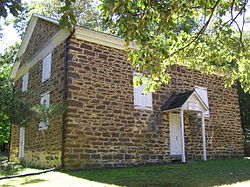
Arney's Mount Friends Meetinghouse and Burial Ground is a historic Quaker meeting house located at the intersection of Mount Holly-Juliustown and Pemberton-Arney's Mount Roads in Arney's Mount, Burlington County, New Jersey, United States.

Rancocas is an unincorporated community located within Westampton Township in Burlington County, New Jersey. The name derives from the Native American word Rankokous, which was used in the name of the Powhatan Lenape Nation Indian Reservation located in Westampton Township. The name was also known as a sub-tribe of the Ancocus. The Reservation was a popular tourist destination for visitors from the Philadelphia area, New York, and local residents, before the Reservation became Rancocas State Park.

Smithburg is an unincorporated community located where the municipal boundaries of Freehold, Manalapan and Millstone townships intersect in Monmouth County, New Jersey, United States. County Route 527 and Monmouth Road pass through the center of the quaint village of Smithburg.

Arneytown is an unincorporated community located along Province Line Road on the border of North Hanover Township in Burlington County and Upper Freehold Township in Monmouth County of New Jersey. It is two miles (3.2 km) north of Jacobstown. Province Line Road was on the boundary line between the Provinces of East Jersey and West Jersey. The area was once called Upper Freehold by 18th-century Quaker settlers. With the establishment of the first post office in 1827, it became known as Arneytown.

Atsion is an unincorporated community located within Shamong Township in Burlington County, New Jersey, United States. The community is located next to Atsion Lake.

The Brainerd Schoolhouse is a one-room schoolhouse located at 35 Brainerd Street in Mount Holly Township, Burlington County, New Jersey, United States. Built in 1759, it is the oldest building of its type in the state and now a museum. Listed as the John Brainard School, it was documented by the Historic American Buildings Survey in 1936. Listed as the Old Schoolhouse, it was added to the National Register of Historic Places on November 26, 2008, for its significance in education. It is a contributing property to the Mount Holly Historic District. It is owned and operated by the National Society of the Colonial Dames of America.
Mount Pleasant is an unincorporated community located along County Route 519 on the border of Alexandria Township and Holland Township, in Hunterdon County, New Jersey. The Mount Pleasant Historic District was listed on the National Register of Historic Places in 1987.

Harbourton is an unincorporated community located within Hopewell Township in Mercer County, New Jersey, United States. It is located along County Route 579 at the intersection with Harbourton-Mount Airy Road. The Harbourton Historic District, encompassing the community, was listed on the state and national registers of historic places in 1974.

Mount Airy is an unincorporated community located within West Amwell Township in Hunterdon County, New Jersey, United States.

Comical Corner or Comical Corners is an unincorporated community located within Pemberton Township in Burlington County, New Jersey, United States. The site of the actual corners is at the intersection of Pemberton Road and Arneys Mount Road. The original name may have been "Conical Corner" based on the cone-like shape of the skewed intersection but had turned to "Comical Corner" based on a mishearing. The area, located just to the north of Pemberton Borough, is mostly rural and is surrounded by farmland on the two obtuse sides of the intersection.