The New Jersey Turnpike (NJTP) is a system of controlled-access highways in the U.S. state of New Jersey, maintained by the New Jersey Turnpike Authority (NJTA). The 117.20-mile (188.62 km) mainline's southern terminus is at the interchange with U.S. Route 130 (US 130) and Route 49, where the split of Interstate 295 (I-295) and US 40 occurs, near the border of Pennsville and Carneys Point townships in Salem County, one mile (1.6 km) east of the Delaware Memorial Bridge. Its northern terminus is at US 46 in Ridgefield Park, Bergen County. Construction of the mainline from concept to completion took 23 months, from 1950 to 1952. It was officially opened to traffic on November 5, 1951, between its southern terminus and exit 10.
Route 38 is a state highway in the southern part of the U.S. state of New Jersey serving the Philadelphia metropolitan area. It extends 19.19 mi (30.88 km) from the Airport Circle, where it intersects U.S. Route 30 and U.S. Route 130, in Pennsauken Township, Camden County to an intersection with U.S. Route 206 and County Route 530 in Southampton Township, Burlington County. The entire route is closely parallel to County Route 537, being only one block away at places. The route is a four- to six-lane divided highway for most of its length and passes through commercial development, residential development, and some farmland.

Burlington County is a county in the U.S. state of New Jersey. The county is the largest in New Jersey by area. Its county seat is Mount Holly. As of the 2019 Census Bureau estimate, the county's population was 445,349, making it the 11th-largest of the state's 21 counties, representing a 0.4% decrease from the 2010 United States Census, when the population was enumerated at 448,734, in turn an increase of 25,340 (6.0%) from the 423,394 enumerated in the 2000 Census. The most-populous place was Evesham Township, with 45,538 residents at the time of the 2010 Census, while Washington Township covered 102.71 square miles (266.0 km2), the largest area of any municipality in Burlington County.

Mount Laurel is a township in Burlington County, New Jersey, United States, and is an edge city suburb of Philadelphia. As of the 2010 United States Census, the township's population was 41,864, reflecting an increase of 1,643 (+4.1%) from the 40,221 counted in the 2000 Census, which had in turn increased by 9,951 (+32.9%) from the 30,270 counted in the 1990 Census. It is the home of NFL Films.

Westampton Township is a township in Burlington County, New Jersey, United States. As of the 2010 United States Census, the township's population was 8,813 reflecting an increase of 1,596 (+22.1%) from the 7,217 counted in the 2000 Census, which had in turn increased by 1,213 (+20.2%) from the 6,004 counted in the 1990 Census.

Florence Township is a township in Burlington County, New Jersey, United States. As of the 2010 United States Census, the township's population was 12,109, reflecting an increase of 1,363 (+12.7%) from the 10,746 counted in the 2000 Census, which had in turn increased by 480 (+4.7%) from the 10,266 counted in the 1990 Census.
Route 68 is a state highway located in Burlington County in the U.S. state of New Jersey, serving as the main connector between the New Jersey Turnpike and the Fort Dix entity of Joint Base McGuire–Dix–Lakehurst. It runs from County Route 616 (CR 616) inside Fort Dix to U.S. Route 206 (US 206) in Mansfield Township, 0.34 mi (0.55 km) south of the New Jersey Turnpike; a total route length of 7.92 mi (12.75 km). The route passes through Wrightstown and Springfield Township as a two-lane undivided road, crossing CR 537. It continues through Mansfield Township as a four-lane divided highway, intersecting with CR 543. Outside of JB MDL, Route 68 passes through mostly agricultural and residential areas.
Route 73 is a state highway in the southern part of the U.S. state of New Jersey. It runs 34.64 mi (55.75 km) as an outer bypass of the Camden area from an intersection with U.S. Route 322 (US 322) in Folsom, Atlantic County to the Tacony–Palmyra Bridge in Palmyra, Burlington County, where it continues into Philadelphia, Pennsylvania as Pennsylvania Route 73. South of the interchange with the Atlantic City Expressway in Winslow Township, Camden County, Route 73 is a two-lane undivided county-maintained road and is signed as County Route 561 Spur, a spur of County Route 561. North of the Atlantic City Expressway, the route is maintained by the New Jersey Department of Transportation and is mostly four lanes, with the portion north of the County Route 561 concurrency a divided highway. North of the US 30 interchange near Berlin, Route 73 runs through suburban areas of the Delaware Valley, intersecting Route 70 in Marlton, the New Jersey Turnpike and Interstate 295 (I-295) in Mount Laurel Township, Route 38 and Route 41 in Maple Shade Township, Route 90 in Cinnaminson Township, and US 130 in Pennsauken Township.
U.S. Route 130 is a U.S. Highway that is a spur route of US 30, located completely within the state of New Jersey. It is signed with north and south cardinal directions, following a general northeast–southwest diagonal path, with "north" corresponding to the general eastward direction and vice versa. The route runs 83.46 mi (134.32 km) from Interstate 295 (I-295) and US 40 at Deepwater in Pennsville Township, Salem County, where the road continues south as Route 49, north to US 1 in North Brunswick Township, Middlesex County, where Route 171 continues north into New Brunswick. The route briefly runs concurrent with US 30 near Camden, about one-third of the way to New Brunswick. The road runs within a close distance of I-295 south of Bordentown and a few miles from the New Jersey Turnpike for its entire length, serving as a major four- to six-lane divided local road for most of its length. US 130 passes through many towns including Penns Grove, Bridgeport, Westville, Camden, Pennsauken, Burlington, Bordentown, Hightstown, and North Brunswick.
Route 90 is a 3.22-mile (5.18 km) state highway in New Jersey in the United States (U.S.). The western terminus is at the Betsy Ross Bridge over the Delaware River in Pennsauken Township, Camden County, where the road continues into Philadelphia, Pennsylvania as an unnumbered road that provides access to Interstate 95. The eastern terminus is an interchange with Route 73 in Cinnaminson Township, Burlington County. It is a four-to six-lane freeway its entire length, interchanging with U.S. Route 130 and Camden County Route 644.
Interstate 295 (I-295) in Delaware, New Jersey, and Pennsylvania is an auxiliary Interstate Highway, designated as a bypass around Philadelphia and a partial beltway of Trenton, New Jersey. The route begins at a junction with I-95 south of Wilmington, Delaware, and runs to an interchange with I-95 in Bristol Township, Pennsylvania. The highway heads east from I-95 and crosses the Delaware River into New Jersey on the Delaware Memorial Bridge concurrent with U.S. Route 40 (US 40). Upon entering New Jersey, I-295 splits from the New Jersey Turnpike and US 40, and runs parallel to the turnpike for most of its course in the state. After a concurrency with US 130 in Gloucester County, I-295 has an interchange with I-76 and Route 42 in Camden County. The freeway continues northeast toward Trenton, where it intersects I-195 and Route 29 before bypassing the city to the east, north, and west, crossing the Delaware River on the Scudder Falls Bridge into Pennsylvania. In Pennsylvania, I-295 is signed as an east–west road and heads south to its other terminus at I-95. I-295 is one of two three-digit interstates in the United States to enter three states, with the other one being the I-275 beltway around Cincinnati which enters Ohio, Indiana, and Kentucky.
Interstate 195 (I-195) is an auxiliary route of the Interstate Highway System located in the U.S. state of New Jersey. Its western end is at I-295 and Route 29 just south of Trenton, New Jersey, in Hamilton Township, Mercer County, while its eastern end is at the Garden State Parkway, Route 34 and Route 138 in Wall Township, Monmouth County. I-195 is 34.17 miles (54.99 km) in length. The route is mostly a four-lane highway that runs through wooded areas in Central Jersey. It has an interchange with the New Jersey Turnpike (I-95) in Robbinsville Township and serves as a main access road to the Six Flags Great Adventure amusement park and the Jersey Shore. I-195 is occasionally referred to as the Central Jersey Expressway. On April 6, 1988, President Ronald Reagan signed H.R. 4263 naming Interstate 195 in New Jersey the James J. Howard Interstate Highway, in honor of the late James J. Howard.
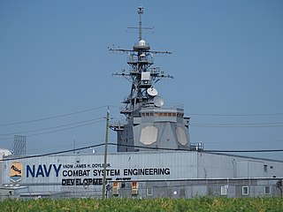
USSRancocas (LS-1) is the former name of an engineering development facility at the border between Moorestown Township and Mount Laurel Township, New Jersey. In May 2008, it was formally renamed the Vice Admiral James H. Doyle, Jr. Combat System Engineering Development Site (CSEDS).
Rowan College at Burlington County (RCBC), is a public community college in Burlington County, New Jersey. Main facilities are located in Mount Laurel with other campuses in Mount Holly, Willingboro and Joint Base.
Interstate 95 (I-95) is a major Interstate Highway that traverses nearly the full extent of the East Coast of the United States, from Florida to Maine. In the state of New Jersey, it runs along much of the mainline of the New Jersey Turnpike, as well as the Pearl Harbor Memorial Extension, and the New Jersey Turnpike's I-95 Extension to the George Washington Bridge for a total of 77.96 mi (125.46 km). Located in the northeastern part of the state near New York City, the 11.03-mile (17.75 km) Western Spur of the New Jersey Turnpike, considered to be Route 95W by the New Jersey Department of Transportation (NJDOT), is also part of I-95.

New Lisbon is an unincorporated community located within Pemberton Township in Burlington County, New Jersey, United States. It is a settlement along Four Mile Road where it intersects Mount Misery Road. The community is located along the Philadelphia and Long Branch Railway, later a part of the Pennsylvania Railroad, and featured a train station.

The George Washington Bridge Plaza, also known as GWB Plaza or Bridge Plaza, is the convergence of roads and highways around the George Washington Bridge toll plaza in Fort Lee, New Jersey, United States. The plaza is located north of and parallel to Fort Lee's Main Street. The surrounding busy area is characterized by a mix of commercial and residential uses and an architectural variety that includes parking lots, strip malls, houses, gas stations, mid-rise office buildings and high-rise condominiums. Just to the east is Fort Lee Historic Park, Palisades Interstate Park and the bridge's western tower.

Rancocas Woods is an unincorporated community located within Mount Laurel Township in Burlington County, New Jersey, United States.
Masonville is an unincorporated community located within Mount Laurel Township, Burlington County, New Jersey, United States. Located east of Moorestown, the community of Masonville was developed when a highway was built in 1794. Major roads in Masonville include County Route 537 and Route 38.
Fellowship is an unincorporated community located within Mount Laurel Township, in Burlington County, New Jersey, United States. The community of Fellowship was originally settled by a Quaker named George Roberts. Fellowship was the most developed of the settlements that comprised Mount Laurel. The community had included two general stores, a wagon shop, a shoe shop, a blacksmith shop, mechanics shops and a boarding school. Today, the community of Fellowship is surrounded by several business establishments and residential subdivisions.


