
Route 38 is a state highway in the southern part of the U.S. state of New Jersey serving the Philadelphia metropolitan area. It extends 19.19 mi (30.88 km) from the Airport Circle, where it intersects U.S. Route 30 and U.S. Route 130, in Pennsauken Township, Camden County to an intersection with U.S. Route 206 and County Route 530 in Southampton Township, Burlington County. The entire route is closely parallel to County Route 537, being only one block away at places. The route is a four- to six-lane divided highway for most of its length and passes through commercial development, residential development, and some farmland.

Mercerville is an unincorporated community and census-designated place (CDP) located within Hamilton Township, in Mercer County, New Jersey, United States. As of the 2010 United States Census, the CDP's population was 13,230. Until after the 2000 Census, the area was part of the Mercerville-Hamilton Square CDP. For the 2010 Census it was split into two CDPs, Mercerville and Hamilton Square.

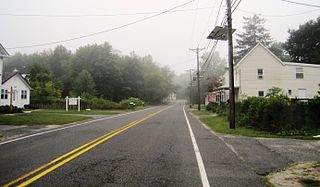
Chairville is a rural unincorporated community located along the border of Medford and Southampton townships in Burlington County, New Jersey, United States. The settlement is named for a chair parts factory that operated from 1845 to 1890. Also located in the area were the Peacock Cemetery, a sawmill, and a one-room schoolhouse. Today, the site is located at the intersection of Chairville Road and New Jersey Route 70 and Little Creek.

Retreat is an unincorporated community and former hamlet located within Southampton Township in Burlington County, New Jersey, United States. The area consists of some residential houses grouped together along Big Hill Road and Retreat Road. A large cranberry bog exists to the southeast of the community while Leisuretowne retirement community is located southwest of here. Most of the remaining area consists of forestland.
Buddtown is an unincorporated community located within Southampton Township in Burlington County, New Jersey, United States. Located between Vincentown and Pemberton, it is named for Thomas Budd who owned farmland in the area in the 18th century. The area itself contains houses and churches in the community itself and farmland surrounding the settlement. The stream that runs through Buddtown is named Stop the Jade Run supposedly named for the cry made by the owners of a runaway horse, "jade" being an old name for a horse.

Burrs Mill is an unincorporated community located within Southampton Township in Burlington County, New Jersey, United States. Found in a rural portion of the township near Route 70, it is located along its eponymous brook in a forested area within the Pine Barrens. A low density of houses surround nearby roads including Burrs Mill Road and Route 70's fire roads.

Nottingham is an unincorporated community located within Hamilton Township in Mercer County, New Jersey, United States. It was named after the English town of Nottingham when the area was settled by English emigrants entering an area of Dutch culture just two decades removed from the land being part of New Netherland, Dutch Empire.

Idell is an unincorporated community located within Kingwood Township in Hunterdon County, New Jersey, United States. The community is located at the crossing of Byram-Kingwood Road over the Lockatong Creek. The area is very rural and consists of small farms, houses, and forest land.

Eayrestown is an unincorporated community located within Lumberton Township in Burlington County, New Jersey, United States. The settlement is named for Richard and Elizabeth Eayres, the first settlers of the site in the 1600s. It was also the first settlement in what is now Lumberton Township. The settlement, located along the South Branch Rancocas Creek, was the site of numerous saw and gristmills early in its history and a picnic grove that attracted people from around the area. Today, numerous farms and housing developments dot the area.

Cooleys Corner is an unincorporated community located within Upper Freehold Township in Monmouth County, New Jersey, United States. The site of the settlement is within the Assunpink Wildlife Management Area, a New Jersey Department of Environmental Protection Division of Fish and Wildlife-operated preserved area in Monmouth and Mercer counties along the Assunpink Creek. Before the creation of the Assunpink Lake in the 1970s, the area consisted of farmland located at the intersection of Clarksburg Road and Imlaystown-Hightstown Road. Some farmland is still present in the area but is now mostly used by hunters. The main boat ramp to Assunpink Lake is located along the former Imlaystown-Hightstown Road.

Ewansville or Ewanville is an unincorporated community located in Burlington County, New Jersey, United States. The community is centered on the crossing of U.S. Route 206 (US 206) and the North Branch Rancocas Creek just north of the former Philadelphia and Long Branch Railway. Ewansville was the site of a station on the aforementioned railroad and was the terminus for a short spur track to Vincentown.

Fairview is an unincorporated community located within Medford Township in Burlington County, New Jersey, United States. The site is part of a strip of commercial businesses located along Stokes Road at its intersection with Skeet Road and Dixontown Road between Medford Lakes and downtown Medford.

Spring Mill is an unincorporated community located within Upper Freehold Township in Monmouth County, New Jersey, United States. The settlement is located along County Route 524 between Hamilton Township and Allentown on a commercialized segment of the road originally built as New Jersey Route 37. A vestige of the state construction remains along the road through a wide right-of-way and a bridge crossing Doctor's Creek stating that it was constructed by the state in 1940 for State Highway Route 37.

Herbertsville is an unincorporated community located within Brick Township in Ocean County, New Jersey, United States. The suburban community is located in the northern reaches of the township centered about the intersection of Herbertsville Road and Lanes Mill Road.

Beaverville is an unincorporated community located within Southampton Township in Burlington County, New Jersey, United States. The area is composed of single-family homes, small businesses and warehouses, forest, and farmland. The community is located along Red Lion Road two miles (3.2 km) south of Vincentown, to the west of U.S. Route 206, and southeast of the Red Lion Airport. Originally, the settlement was the site of a one-room schoolhouse.

Browns Mills Junction is an unincorporated community located within Pemberton Township in Burlington County, New Jersey, United States. The site, located about 1.6 miles (2.6 km) southwest of downtown Browns Mills, is located at the crossing of Junction Road and the Philadelphia and Long Branch Railway, later a part of the Pennsylvania Railroad. It was the site of a train station named Browns Mills in-the-Pines where a short branch connected the main line to Browns Mills. The settlement features a few houses along Junction Road and Mount Misery Road but is otherwise very forested as a part of the New Jersey Pine Barrens.

Dunns Mill or Dunns Mills is an unincorporated community located within Bordentown Township in Burlington County, New Jersey, United States. The site is named for a gristmill established in 1708 that is located near the settlement along Blacks Creek. Martin Luther Dunn purchased the mill in 1875 but burned down in 1901. The site is presently located near the crossing of the New Jersey Turnpike over County Route 545. A mix of housing developments and preserved open space are located around Dunns Mill today.

Ellisdale is an unincorporated community located along the border of North Hanover Township in Burlington County and Upper Freehold Township in Monmouth County, in New Jersey, United States. The community is centered about the intersection of Province Line Road and Hill Road / Ellisdale-Crosswicks Road. The Crosswicks Creek runs to the north of the settlement and the nearby Ellisdale Fossil Site takes its name from Ellisdale.

Newbolds Corner is an unincorporated community located within Lumberton Township in Burlington County, New Jersey, United States. The site, located at the corner of Eayrestown Road and Newbolds Corner Road, was once home to a Nike missile silo which was fully demolished in late 2015. Today, the west side of Eayrestown Road consists of housing developments, Lumberton Township's town hall, and a school, while the east side of the road features farmland.

Lake Neepaulin is a small man-made freshwater lake located in Wantage Township in Sussex County, New Jersey in the United States. Located in the watershed of Papakating Creek, a tributary of the Wallkill River, the lake was created in the 1950s by damming an unnamed mountain stream as the feature of a private residential development. The stream, now known as Neepaulakating Creek, did not receive a name until 2002.


