
Southampton Township is a township in Burlington County, New Jersey, United States. As of the 2010 United States Census, the township's population was 10,464 reflecting an increase of 76 (+0.7%) from the 10,388 counted in the 2000 Census, which had in turn increased by 186 (+1.8%) from the 10,202 counted in the 1990 Census.

Sandtown is an unincorporated community located within Southampton Township in Burlington County, New Jersey, United States. The settlement is located at the modern-day intersection of Sandtown Road and New Freedom Road. Little Creek runs to the west of Sandtown and forms the border between Southampton and Medford townships. A small grouping of homes is located along the two aforementioned roads in Sandtown while the remainder of the Southampton side of the creek consists of farmland. Route 70 is the closest major road near Sandtown.

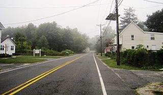
Chairville is a rural unincorporated community located along the border of Medford and Southampton townships in Burlington County, New Jersey, United States. The settlement is named for a chair parts factory that operated from 1845 to 1890. Also located in the area were the Peacock Cemetery, a sawmill, and a one-room schoolhouse. Today, the site is located at the intersection of Chairville Road and New Jersey Route 70 and Little Creek.

Retreat is an unincorporated community and former hamlet located within Southampton Township in Burlington County, New Jersey, United States. The area consists of some residential houses grouped together along Big Hill Road and Retreat Road. A large cranberry bog exists to the southeast of the community while Leisuretowne retirement community is located southwest of here. Most of the remaining area consists of forestland.
Buddtown is an unincorporated community located within Southampton Township in Burlington County, New Jersey, United States. Located between Vincentown and Pemberton, it is named for Thomas Budd who owned farmland in the area in the 18th century. The area itself contains houses and churches in the community itself and farmland surrounding the settlement. The stream that runs through Buddtown is named Stop the Jade Run supposedly named for the cry made by the owners of a runaway horse, "jade" being an old name for a horse.

Burrs Mill is an unincorporated community located within Southampton Township in Burlington County, New Jersey, United States. Found in a rural portion of the township near Route 70, it is located along its eponymous brook in a forested area within the Pine Barrens. A low density of houses surround nearby roads including Burrs Mill Road and Route 70's fire roads.

Burlington Heights is an unincorporated community located within Freehold Township in Monmouth County, New Jersey, United States. The community was created in the early 1960s and originally consisted of 112 homes of mixed styles designed by Peter Petillo and Associates of Freehold. It is located along Colts Neck Road on the east side of the township, near New Jersey Route 18 and the Colts Neck municipal line.

Ewansville or Ewanville is an unincorporated community located in Burlington County, New Jersey, United States. The community is centered on the crossing of U.S. Route 206 (US 206) and the North Branch Rancocas Creek just north of the former Philadelphia and Long Branch Railway. Ewansville was the site of a station on the aforementioned railroad and was the terminus for a short spur track to Vincentown.

Four Mile is an unincorporated community located within Woodland Township, in Burlington County, New Jersey, United States. The Four Mile Circle, where Route 70 and Route 72 intersect, is located in Four Mile, near the border of Pemberton and Southampton townships. Except for small businesses along Route 72, a small residential cluster southeast of the circle, and the New Lisbon Developmental Center located about one mile (1.6 km) from the circle, the area is composed of forest that makes up the New Jersey Pine Barrens.

Beaverville is an unincorporated community located within Southampton Township in Burlington County, New Jersey, United States. The area is composed of single-family homes, small businesses and warehouses, forest, and farmland. The community is located along Red Lion Road two miles (3.2 km) south of Vincentown, to the west of U.S. Route 206, and southeast of the Red Lion Airport. Originally, the settlement was the site of a one-room schoolhouse.

Berlin Heights is an unincorporated community located within Evesham Township in Burlington County, New Jersey, United States.
Birchfield is an unincorporated community located within Mount Laurel Township in Burlington County, New Jersey, United States.
Bortons Landing or Borton Landing is an unincorporated community located along the border of Moorestown and Willingboro townships in Burlington County, New Jersey, United States.

Bullock is an unincorporated community that straddles Woodland Township, Burlington County and Manchester Township, Ocean County in the middle of the New Jersey Pine Barrens. Much of the area surrounding Bullock is a part of the Brendan T. Byrne State Forest though there are some clearings for small houses along Savoy Boulevard in Woodland Township and Pasadena Road in Manchester Township. The settlement is located where these two roads, the New Jersey Southern Railroad, and the Keith line converge.
Cambridge or Cambridge Park is an unincorporated community located within Evesham Township in Burlington County, New Jersey, United States.

Crossroads is an unincorporated community located within Medford Township in Burlington County, New Jersey, United States. It is centered at the intersection of Medford-Mt. Holly Road and Church Road.

Davisville is an unincorporated community located within Chesterfield Township in Burlington County, New Jersey, United States. The settlement, located at the intersection of County Route 528 and Chesterfield-Arneytown Road, is in a rural area in the eastern portion of the township. It consists mainly of farmland with some houses dotting the few roads that pass through the area.
Earlys Crossing was an unincorporated community located within Pemberton Township in Burlington County, New Jersey, United States.

Ellisdale is an unincorporated community located along the border of North Hanover Township in Burlington County and Upper Freehold Township in Monmouth County, in New Jersey, United States. The community is centered about the intersection of Province Line Road and Hill Road / Ellisdale-Crosswicks Road. The Crosswicks Creek runs to the north of the settlement and the nearby Ellisdale Fossil Site takes its name from Ellisdale.

Red Lion is an unincorporated community located within Southampton Township in Burlington County, New Jersey, United States.


