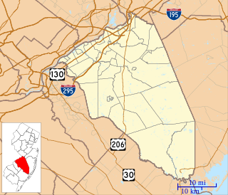
Bordentown is a city in Burlington County, New Jersey, United States. As of the 2010 United States Census, the city's population was 3,924. The population declined by 45 (-1.1%) from the 3,969 counted in the 2000 U.S. Census, which had in turn declined by 372 (-8.6%) from the 4,341 counted in the 1990 Census.

Fieldsboro is a borough in Burlington County, New Jersey, United States. As of the 2010 United States Census, the borough's population was 540, reflecting an increase of 18 (+3.4%) from the 522 counted in the 2000 Census, which had in turn declined by 57 (-9.8%) from the 579 counted in the 1990 Census.

Bordentown Township is a township in Burlington County, New Jersey, United States. As of the 2010 United States Census, the population was 11,367, representing an increase of 2,987 (+35.6%) from the 8,380 counted in the 2000 Census, which had in turn increased by 697 (+9.1%) from the 7,683 counted in the 1990 Census.

The Geographic Names Information System (GNIS) is a database that contains name and locative information about more than two million physical and cultural features located throughout the United States of America and its territories. It is a type of gazetteer. GNIS was developed by the United States Geological Survey in cooperation with the United States Board on Geographic Names (BGN) to promote the standardization of feature names.

The United States Board on Geographic Names (BGN) is a federal body operating under the United States Secretary of the Interior. The purpose of the board is to establish and maintain uniform usage of geographic names throughout the federal government of the United States.

East Spotswood, also known as the settlement of Old Bridge, is an unincorporated community located within East Brunswick, New Jersey and Old Bridge townships in Middlesex County, New Jersey, United States. The area is made up of homes, businesses, and wetlands for the South River. The area is located at the junction of New Jersey Route 18, County Route 527, the western end of CR 516, and the Bordentown and South Amboy Turnpike. The still-active Jamesburg Branch of the former Camden & Amboy Railroad also runs through the community.

Ardmore Estates is an unincorporated community located within Howell Township in Monmouth County, New Jersey, United States. The community is located along County Route 524 in the western part of the township. With construction dating back to the 1950s, the neighborhood is one of the oldest residential developments in Howell. The community sits adjacent to the Manasquan River and Howell Memorial and Adelphia Schools.

Burlington Heights is an unincorporated community located within Freehold Township in Monmouth County, New Jersey, United States. The community was created in the early 1960s and originally consisted of 112 homes of mixed styles designed by Peter Petillo and Associates of Freehold. It is located along Colts Neck Road on the east side of the township, near New Jersey Route 18 and the Colts Neck municipal line.

Bellview is an unincorporated community located within Cinnaminson Township in Burlington County, New Jersey, United States.

Birchfield is an unincorporated community located within Mount Laurel Township in Burlington County, New Jersey, United States.

Bortons Landing or Borton Landing is an unincorporated community located along the border of Moorestown and Willingboro townships in Burlington County, New Jersey, United States.

Browns Mills Junction is an unincorporated community located within Pemberton Township in Burlington County, New Jersey, United States. The site, located about 1.6 miles (2.6 km) southwest of downtown Browns Mills, is located at the crossing of Junction Road and the Philadelphia and Long Branch Railway, later a part of the Pennsylvania Railroad. It was the site of a train station named Browns Mills in-the-Pines where a short branch connected the main line to Browns Mills. The settlement features a few houses along Junction Road and Mount Misery Road but is otherwise very forested as a part of the New Jersey Pine Barrens.

Cambridge or Cambridge Park is an unincorporated community located within Evesham Township in Burlington County, New Jersey, United States.

Charcoal Landing was an unincorporated community located within Bass River Township in Burlington County, New Jersey, United States.

Comical Corner or Comical Corners is an unincorporated community located within Pemberton Township in Burlington County, New Jersey, United States. The site of the actual corners is at the intersection of Pemberton Road and Arneys Mount Road. The original name may have been "Conical Corner" based on the cone-like shape of the skewed intersection but had turned to "Comical Corner" based on a mishearing. The area, located just to the north of Pemberton Borough, is mostly rural and is surrounded by farmland on the two obtuse sides of the intersection.

Crescent Heights is an unincorporated community located within Southampton Township in Burlington County, New Jersey, United States.

Dunns Mill or Dunns Mills is an unincorporated community located within Bordentown Township in Burlington County, New Jersey, United States. The site is named for a gristmill established in 1708 that is located near the settlement along Blacks Creek. Martin Luther Dunn purchased the mill in 1875 but burned down in 1901. The site is presently located near the crossing of the New Jersey Turnpike over County Route 545. A mix of housing developments and preserved open space are located around Dunns Mill today.

Earlys Crossing was an unincorporated community located within Pemberton Township in Burlington County, New Jersey, United States.

Lake Neepaulin is a small man-made freshwater lake located in Wantage Township in Sussex County, New Jersey in the United States. Located in the watershed of Papakating Creek, a tributary of the Wallkill River, the lake was created in the 1950s by damming an unnamed mountain stream as the feature of a private residential development. The stream, now known as Neepaulakating Creek, did not receive a name until 2002.


