
Lumberton is a township in Burlington County, New Jersey, United States. As of the 2010 United States Census, the township's population was 12,559, reflecting an increase of 2,098 (+20.1%) from the 10,461 counted in the 2000 Census, which had in turn increased by 3,756 (+56.0%) from the 6,705 counted in the 1990 Census.

Sandy Hook is a barrier spit in Middletown Township, Monmouth County, New Jersey, United States.

Campgaw Mountain Reservation is a 1351-acre (5.5 km2) county park of Bergen County, New Jersey. It is located mostly within Mahwah, but extends into the northeastern part of Oakland, as well as the northwestern part of Franklin Lakes. The park includes a ski area and the peak of Campgaw Mountain at a 735-foot (224 m) elevation.
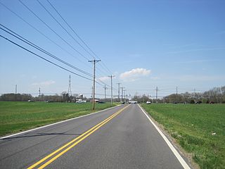
Fostertown is an unincorporated community located within Lumberton Township, in Burlington County, New Jersey, United States. The site was founded in 1735 by William Foster where he set up a plantation on modern-day West Bella Bridge Road. The area is largely farmland with some houses and a high-voltage power line dotting the landscape.
The Martin AN/FSG-1 Antiaircraft Defense System, better known as Missile Master, was an electronic fire distribution center to computerize Cold War air defense (AD) command posts from manual plotting board operations to automated command and control of remote surface-to-air missile (SAM) launch batteries. The 10 United States Army C3 systems used radar netting ("electronic umbrella") at Missile Master military installations for coordinating ground-controlled interception by Nike and MIM-23 Hawk missiles. The vacuum tube fire control logic reduced the time to designate the appropriate missile battery to launch if an enemy target had intruded into a defense area where an AN/FSG-1 system was deployed.

Chairville is a rural unincorporated community located along the border of Medford and Southampton townships in Burlington County, New Jersey, United States. The settlement is named for a chair parts factory that operated from 1845 to 1890. Also located in the area were the Peacock Cemetery, a sawmill, and a one-room schoolhouse. Today, the site is located at the intersection of Chairville Road and New Jersey Route 70 and Little Creek.

Missile Master was a type of US Army Missile Command military installation for the Cold War Project Nike, each which were a complex of systems and facilities for surface-to-air missile command and control. Each Missile Master had a nuclear bunker housing the Martin AN/FSG-1 Antiaircraft Defense System, as well as additional "tactical structures" for "an AN/FPS-33 defense acquisition radar (DAR) or similar radar, two height-finder radars," and identification friend or foe secondary radar. The radars, along with Automated Data Links (ADL) from remote Nike firing units, provided data into the AN/FSG-1 tracking subsystem with the DAR providing surveillance coverage to about 200 mi (320 km).
The Highlands Army Air Defense Site (HAADS) was a United States Army air defence site in Middletown Township, New Jersey.

Chapel Hill is an unincorporated community located within Middletown Township, in Monmouth County, New Jersey, United States. As its name implies, the area is on a high spot within the township between Fairview and Leonardo just south of the Naval Weapons Station Earle Waterfront Section. Unlike other areas of Middletown Township, the Chapel Hill section is not as developed with single-family homes; only a few housing developments are located off the area's main roads, Kings Highway and Chapel Hill Road. The rest of the area outside NWS Earle consists of horse farms and forestland.

Harneys Corner is an unincorporated community located within Lawrence Township in Mercer County, New Jersey, United States. It is located at the intersection of Lawrence Road and Princeton Pike / Avenue. Located in the southern portion of the township close to the Trenton and Ewing borders, the area consists of small houses on nearby side streets and businesses along the aforementioned arterial roads. The intersection itself is located about 0.3 miles (0.48 km) north of the Brunswick Circle.

Eayrestown is an unincorporated community located within Lumberton Township in Burlington County, New Jersey, United States. The settlement is named for Richard and Elizabeth Eayres, the first settlers of the site in the 1600s. It was also the first settlement in what is now Lumberton Township. The settlement, located along the South Branch Rancocas Creek, was the site of numerous saw and gristmills early in its history and a picnic grove that attracted people from around the area. Today, numerous farms and housing developments dot the area.

Cooleys Corner is an unincorporated community located within Upper Freehold Township in Monmouth County, New Jersey, United States. The site of the settlement is within the Assunpink Wildlife Management Area, a New Jersey Department of Environmental Protection Division of Fish and Wildlife-operated preserved area in Monmouth and Mercer counties along the Assunpink Creek. Before the creation of the Assunpink Lake in the 1970s, the area consisted of farmland located at the intersection of Clarksburg Road and Imlaystown-Hightstown Road. Some farmland is still present in the area but is now mostly used by hunters. The main boat ramp to Assunpink Lake is located along the former Imlaystown-Hightstown Road.
Crawford Corners or Crawfords Corner is an unincorporated community located within Holmdel Township in Monmouth County, New Jersey, United States. The settlement is located at the intersection of Holmdel Road and Crawfords Corners Road in the hilly northern portion of the township. The settlement is located about one-half mile (0.80 km) from Crawford Hill, the highest point in Monmouth County. The area also includes the township's town hall, police department, and high school in addition to a New Jersey State Police barracks and the PNC Bank Arts Center off the Garden State Parkway. These buildings and landmarks comprise the eastern section of the settlement, homes and heavily treed lands are located on the west side of Holmdel Road, and Holmdel Park makes up the southern portion of the area.

Lower Squankum is an unincorporated community located within Howell Township in Monmouth County, New Jersey, United States. The settlement is located along Lakewood-Farmingdale Road at its intersection with Herbertsville Road and Old Tavern Road in the eastern side of the township. It is also located near the boundary of Allaire State Park and is south of Interstate 195's exit 31. Nearby the community are the remains of the Lower Squankum Mill and the Lower Squankum Friends Burial Site, located within the median of CR 547 at the aforementioned interchange.

Morrells Corner or Morrell Corners is an unincorporated community located within Holmdel and Hazlet townships in Monmouth County, New Jersey, United States. The main north–south road through here is Holmdel Road, and the main east–west road is Bethany Road. Most of the area is suburban and consists of homes alongside roads with some businesses and the Hazlet NJ Transit station along the main roads.

Fairview is an unincorporated community located within Medford Township in Burlington County, New Jersey, United States. The site is part of a strip of commercial businesses located along Stokes Road at its intersection with Skeet Road and Dixontown Road between Medford Lakes and downtown Medford.

Smocks Corner or Smocks Corners is an unincorporated community located within Marlboro Township in Monmouth County, New Jersey, United States. Located at the intersection of Pleasant Valley Road and Conover Road, the area is mostly residences with some open space and farmland. It was called "Smocks Corner" because the Smock Family had houses in that area, both sides of the street back in the 1700s.

Browns Mills Junction is an unincorporated community located within Pemberton Township in Burlington County, New Jersey, United States. The site, located about 1.6 miles (2.6 km) southwest of downtown Browns Mills, is located at the crossing of Junction Road and the Philadelphia and Long Branch Railway, later a part of the Pennsylvania Railroad. It was the site of a train station named Browns Mills in-the-Pines where a short branch connected the main line to Browns Mills. The settlement features a few houses along Junction Road and Mount Misery Road but is otherwise very forested as a part of the New Jersey Pine Barrens.

Comical Corner or Comical Corners is an unincorporated community located within Pemberton Township in Burlington County, New Jersey, United States. The site of the actual corners is at the intersection of Pemberton Road and Arneys Mount Road. The original name may have been "Conical Corner" based on the cone-like shape of the skewed intersection but had turned to "Comical Corner" based on a mishearing. The area, located just to the north of Pemberton Borough, is mostly rural and is surrounded by farmland on the two obtuse sides of the intersection.


