
The Sabine River is a river, 510 miles (820 km) long, in the Southern U.S. states of Texas and Louisiana. In its lower course, it forms part of the boundary between the two states and empties into Sabine Lake, an estuary of the Gulf of Mexico. Over the first half of the 19th century, the river formed part of the Spanish–American, Mexican–American, and Texan–American international boundaries. The upper reaches of the river flow through the prairie country of northeast Texas. Along much of its lower reaches, it flows through the pine forests along the Texas–Louisiana border, and the bayou country near the Gulf Coast.

A tributary or affluent is a stream or river that flows into a larger stream or main stem river or a lake. A tributary does not flow directly into a sea or ocean. Tributaries and the main stem river drain the surrounding drainage basin of its surface water and groundwater, leading the water out into an ocean.

Grand Forks Air Force Base (AFB) is a United States Air Force installation in northeastern North Dakota, located north of Emerado and 16 miles (26 km) west of Grand Forks. In the 2010 census, the base was counted as a census-designated place with a total population of 2,367, down from 4,832 in 2000.

The Cumberland River is a major waterway of the Southern United States. The 688-mile-long (1,107 km) river drains almost 18,000 square miles (47,000 km2) of southern Kentucky and north-central Tennessee. The river flows generally west from a source in the Appalachian Mountains to its confluence with the Ohio River near Paducah, Kentucky, and the mouth of the Tennessee River. Major tributaries include the Obey, Caney Fork, Stones, and Red rivers.

The Salmon River is located in Idaho in the northwestern United States. The Salmon is also known as "The River of No Return". It flows for 425 miles (685 km) through central Idaho, draining a rugged, thinly populated watershed of 14,000 square miles (36,000 km2) and dropping more than 7,000 feet (2,100 m) between its headwaters, near Galena Summit above the Sawtooth Valley in the Sawtooth National Recreation Area, and its confluence with the Snake River. Measured at White Bird, its average discharge is 11,060 cubic feet per second. It is one of the largest rivers in the continental United States without a single dam on its mainstem.

The Pocomoke River stretches approximately 66 miles (106 km) from southern Delaware through southeastern Maryland in the United States. At its mouth, the river is essentially an arm of Chesapeake Bay, whereas the upper river flows through a series of relatively inaccessible wetlands called the Great Cypress Swamp, largely populated by Loblolly Pine, Red Maple and Bald Cypress. The river is the easternmost river that flows into Chesapeake Bay. "Pocomoke", though traditionally interpreted as "dark water" by local residents, is now agreed by scholars of the Algonquian languages to be derived from the words for "broken ground."

The Alsea River flows 48.5 miles (78.1 km) from Alsea, an unincorporated community in the coastal mountains of the U.S. state of Oregon, to the Pacific Ocean near the city of Waldport. It begins at the confluence of the North Fork Alsea River and the South Fork Alsea River and ends in Alsea Bay, a wide estuary at Waldport. The river flows generally west-northwest in a winding course through the mountains of southern Benton and Lincoln counties, passing near the unincorporated community of Tidewater and through the Siuslaw National Forest. Its drainage basin extends into Lane County, along the headwaters of the South Fork Alsea River.

USS Grand Forks (PG-119/PF-11), a Tacoma-class patrol frigate, was the only ship of the United States Navy to be named for Grand Forks, North Dakota.

Temescal Creek is one of the principal watercourses in the city of Oakland, California, United States.
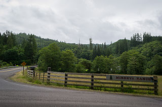
Minerva is an unincorporated community in Lane County, Oregon, United States. It is located about 13 miles (21 km) northeast of Florence near the North Fork Siuslaw River within the Siuslaw National Forest.

Eel River Township is one of twelve townships in Hendricks County, Indiana, United States. As of the 2010 census, its population was 1,662.

The Middle Fork Feather River is a major river in Plumas and Butte Counties in the U.S. state of California. Nearly 100 miles (160 km) long, it drains about 1,062 square miles (2,750 km2) of the rugged northern Sierra Nevada range.

South Fork Township is one of eight townships in Audrain County, Missouri, United States. As of the 2010 census, its population was 5,431.

Capps Creek Township is one of twenty-five townships in Barry County, Missouri, United States. As of the 2000 census, its population was 570.
Adair Township is one of eleven townships in Camden County, Missouri, USA. As of the 2000 census, its population was 2,780.

Osage Township is one of eleven townships in Camden County, Missouri, USA. As of the 2000 census, its population was 4,726.

King William County is a county located in the U.S. state of Virginia. As of the 2010 census, the population was 15,935. Its county seat is King William.

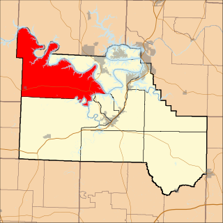
The North Fork Siuslaw River is a tributary of the Siuslaw River in Lane County in the United States state of Oregon. It is formed by the confluence of Sam Creek and West Branch in the Siuslaw National Forest of the Central Oregon Coast Range. The former community of Pawn was once at the juncture of the two creeks. From here, the river flows about 2 miles (3 km) southeast, then about 25 miles (40 km) southwest to meet the main stem 1.2 miles (1.9 km) east of Florence.

Union District, formerly Union Magisterial District, is one of five historic magisterial districts in Jackson County, West Virginia. The district was originally known as Hushan's Mills Township, one of five civil townships established in 1863, at the height of the Civil War; it was subsequently given the patriotic name of Union Township. In 1872, West Virginia's townships were converted into magisterial districts. When Jackson County was redistricted in the 1990s, the area of Union District was included in the new Western Magisterial District. However, the county's historic magisterial districts continue to exist in the form of tax districts, serving all of their former administrative functions except for the election of county officials.

The Western Magisterial District is one of three magisterial districts in Jackson County, West Virginia. It was established during a process of redistricting undertaken in the 1990s. In 2010, 10,576 people lived in the district.


