
Essex County is located in the northeastern part of the U.S. state of New Jersey, and is one of the centrally located counties in the New York metropolitan area. As of the 2020 census, the county was the state's second-most populous county, with a population of 863,728, its highest decennial count since the 1970 census and an increase of 79,759 (+10.2%) from the 2010 census count of 783,969.
Scouting in New Jersey has a long history, from the 1910s to the present day, serving thousands of youth in programs that suit the environment in which they live. The second Boy Scouts of America National Headquarters was in North Brunswick, although it was referred to in BSA publications as being in neighboring New Brunswick.
Montclair is a township in Essex County in the U.S. state of New Jersey. Situated on the cliffs of the Watchung Mountains, Montclair is a wealthy and diverse suburban commuter town of New York City within the New York metropolitan area. As of the 2020 United States census, the township's population was 40,921, an increase of 3,252 (+8.6%) from the 2010 census count of 37,669, which in turn reflected a decline of 1,308 (−3.4%) from the 38,977 counted in the 2000 census. As of 2010, it was the 60th-most-populous municipality in New Jersey.

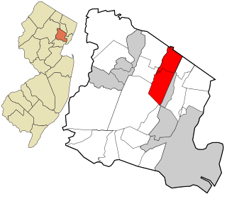
Verona is a township in Essex County in the U.S. state of New Jersey. As of the 2020 United States census, the township's population was 14,572, an increase of 1,240 (+9.3%) from the 2010 census count of 13,332, which in turn reflected a decline of 201 (−1.5%) from the 13,533 counted in the 2000 census.

Eagle Rock Reservation is a 408.33-acre forest reserve and recreational park in the First Watchung Mountain of New Jersey (U.S.), located in the communities of West Orange, Montclair, and Verona. The land is owned and administered by the Essex County Department of Parks, Recreation and Cultural Affairs.

The Passaic River is a river, approximately 80 miles (130 km) long, in Northern New Jersey. The river in its upper course flows in a highly circuitous route, meandering through the swamp lowlands between the ridge hills of rural and suburban northern New Jersey, called the Great Swamp, draining much of the northern portion of the state through its tributaries.

The Watchung Mountains are a group of three long low ridges of volcanic origin, between 400 and 500 feet high, lying parallel to each other in northern New Jersey in the United States. The name is derived from the American Native Lenape name for them, Wach Unks. The Watchung Mountains are known for their numerous scenic vistas overlooking the skylines of New York City and Newark, New Jersey, as well as their isolated ecosystems containing rare plants, endangered wildlife, rich minerals, and globally imperiled trap rock glade communities. The ridges traditionally contained the westward spread of urbanization, forming a significant geologic barrier beyond the piedmont west of the Hudson River; the town of Newark, for example, once included lands from the Hudson to the base of the mountains. Later treaties moved the boundary to the top of the mountain, to include the springs.
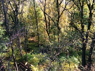
Mills Reservation is a county park, consisting of a 157.15-acre (0.6360 km2) protected wooded area located in Cedar Grove and Montclair, New Jersey, United States. The reservation is maintained by the Essex County Park Commission. The reservation has several walking and jogging trails, including the Lenape Trail, four major trails, and two smaller trails. One of the four main trails leads to a cliff that overlooks the New York City skyline.

County Route 506 is a county highway in the U.S. state of New Jersey. The highway extends 10.78 miles (17.35 km) from Oak Road in Fairfield to Route 7 at the Passaic River in Belleville.

The Gateway Region is the primary urbanized area of the northeastern section of New Jersey. It is anchored by Newark, the state's most populous city. While sometimes known as the Newark metropolitan area, it is part of the New York metropolitan area.

The Northern New Jersey Council was formed in January 1999 and serves Bergen, Essex, Hudson and Passaic counties as an effort to better serve the Scouting communities encompassed in these areas.
The Essex County Park System comprises the county-run parks of Essex County, New Jersey. The Essex County Department of Parks, Recreation and Cultural Affairs is in charge of the upkeep and preservation of the parks, reservations and a number of other facilities, including golf courses and trails.

The New York and Greenwood Lake Railway owned a line between Croxton, Jersey City, New Jersey and Greenwood Lake, New York. Service on the line was provided by the Erie Railroad.

The Montclair-Boonton Line is a commuter rail line of New Jersey Transit Rail Operations in the United States. It is part of the Hoboken Division. The line is a consolidation of three individual lines: the former Delaware, Lackawanna & Western Railroad's Montclair Branch, which ran from Hoboken Terminal to Bay Street, Montclair; the Erie Railroad's Greenwood Lake Division, which originally ran from the Erie's Jersey City Terminal to Greenwood Lake, NY; and the former Lackawanna Boonton Line, which ran from Hoboken to Hackettstown, New Jersey. The Montclair-Boonton line was formed when the Montclair Connection opened on September 30, 2002. The line serves 28 active rail stations in New Jersey along with New York Pennsylvania Station. It crosses through six counties, serving six stations in the township of Montclair, two in the town of Bloomfield, and one in the city of Newark. Trains along the Montclair-Boonton Line heading eastward usually originate at Hackettstown, Mount Olive, Lake Hopatcong, Dover, or Montclair State University, bound for either Hoboken Terminal or New York Penn Station. On system maps the line is colored maroon and its symbol is a bird, after the state bird, the eastern goldfinch.
Yantacaw Brook is a tributary of the Third River in Essex County, New Jersey, United States. The brook rises in Montclair and then continues into the Third River in Bloomfield, New Jersey and then into Belleville and Nutley, where it enters the Passaic River. Both Yantacaw Brook and the Third River were referred to by the Lenape people as Yantokah or Yantacaw.

WR Draw is an out-of-service railroad bridge crossing the Passaic River between Newark and the Arlington section of Kearny, New Jersey. The plate girder rim-bearing swing bridge, originally built in 1897 and modified in 1911 and 1950, is the 14th bridge from the river's mouth at Newark Bay and is 8.1 miles (13.0 km) upstream from it. Last used for regular passenger service in 2002, it is welded in closed position as its height is not considered a hazard to navigation.
The North Jersey Super Football Conference is a football-only athletic league of high schools in New Jersey. The 115-team league was formed in 2016.

North Newark was a former commuter railroad train station in the Woodside section of the city of Newark, Essex County, New Jersey. Located at the intersection of Broadway and Verona Avenues, the station served trains on NJ Transit's Boonton Line, which operated at the time between Netcong and Hoboken Terminal. The station consisted of two low-level side platforms, accessible by stairs from Broadway. The next station to the east was Arlington in nearby Kearny, with the next station to the west being Rowe Street in Bloomfield.
