
Rockland County is the southernmost county on the west side of the Hudson River in the U.S. state of New York. It is part of the New York metropolitan area. As of the 2020 U.S. census, the county's population is 338,329, making it the state's third-most densely populated county outside New York City after Nassau and neighboring Westchester counties. The county seat and largest hamlet is New City. Rockland County is accessible via both the New York State Thruway, which crosses the Hudson River to Westchester via the Tappan Zee Bridge over the Tappan Zee, ten exits up from the NYC border; and the Palisades Parkway, four exits up, via the George Washington Bridge. The county's name derives from "rocky land", as the area has been aptly described, largely due to the Hudson River Palisades. The county is part of the Hudson Valley region of the state.

Route 17 is a state highway in Bergen County, New Jersey, United States, that provides a major route from the George Washington Bridge, Lincoln Tunnel and other northeast New Jersey points to the New York State Thruway at Suffern, New York. It runs 27.20 mi (43.77 km) from an intersection with Route 7 and County Route 507 (CR 507) in North Arlington north to the New York state line along Interstate 287 (I-287) in Mahwah, where New York State Route 17 (NY 17) continues into New York. Between Route 7 and Route 3 in Rutherford, Route 17 serves as a local road. From Route 3 north to the junction with U.S. Route 46 (US 46) in Hasbrouck Heights, the road is an arterial road with jughandles. The portion of Route 17 from US 46 to I-287 near the state line in Mahwah is a four- to six-lane arterial with all cross traffic handled by interchanges, and many driveways and side streets accessed from right-in/right-out ramps from the right lane. For three miles (5 km) north of Route 4, well over a hundred retail stores and several large shopping malls line the route in the borough of Paramus. The remainder of this portion of Route 17 features lighter suburban development. The northernmost portion of Route 17 in Mahwah runs concurrently with I-287 to the New York state line.
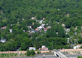
Hillburn, originally called "Woodburn" and incorporated in 1893, is a village in the town of Ramapo, Rockland County, New York, United States. It is located north of Suffern, east of Orange County, south of Viola, and west of Montebello. It is considered to be one of the more rural communities in Rockland County. The population was 930 at the 2020 census.

Montebello is an incorporated village in Ramapo, Rockland County, New York, United States. It is located north of Suffern, east of Hillburn, south of Wesley Hills, and west of Airmont. The population was 4,507 at the 2020 census.

Ramapo is a town in Rockland County, New York, United States. It was originally formed as New Hampstead, in 1791, and became Ramapo in 1828. It shares its name with the Ramapo River. As of the 2020 census, Ramapo had a total population of 148,919, making it the most populous town in New York outside of Long Island. If all towns in New York were cities, Ramapo would be the 12th-largest city in the state of New York.

Sloatsburg is a village in the town of Ramapo in Rockland County, New York, United States. Located east of Orange County, it is at the southern entrance to Harriman State Park. The population was 3,036 at the 2020 census. The village is named after Stephen Sloat, an early European landowner.
Suffern is a village that was incorporated in 1796 in the town of Ramapo in Rockland County, New York. Located adjacent to the town of Mahwah, New Jersey, Suffern is located 31 miles northwest of Manhattan. As of the 2020 census, Suffern's population was 11,402.

The Ramapo Mountains are a forested chain of the Appalachian Mountains in northeastern New Jersey and southeastern New York, in the United States. They range in height from 900 to 1,200 feet in New Jersey, and 900 to 1,400 feet in New York.
Ramapo is the name of several places and institutions in northern New Jersey and southeastern New York State. They were named after the Ramapough, a band of the Lenape Indians who migrated into the area from Connecticut by the seventeenth and early eighteenth centuries.

The Ramapo River is a tributary of the Pompton River, approximately 30 mi (48 km) long, in southern New York and northern New Jersey in the United States.

The Main Line is a commuter rail line owned and operated by New Jersey Transit running from Suffern, New York to Hoboken, New Jersey, in the United States. It runs daily commuter service and was once the north–south main line of the Erie Railroad. It is colored yellow on NJ Transit system maps, and its symbol is a water wheel.
At 47,527 acres (192.33 km2), Harriman State Park is the second largest state park in the U.S. state of New York. Located in Rockland and Orange counties 30 miles (48 km) north of New York City, it is a haven for hikers with over 200 miles (320 km) of hiking trails. The park is also known for its 31 lakes, multiple streams, public camping area, and great vistas. The park's hiking trails are currently maintained by volunteers from the New York - New Jersey Trail Conference.
The Saddle River flows south through much of Bergen County, New Jersey. The river runs through densely populated suburban areas for much of its course. The river takes its name from the river near Saddell in Argyll and Bute in Scotland.
Ramapo Mountain State Forest is a 4,200-acre (17 km2) state forest in Bergen and Passaic Counties in New Jersey. The park is operated and maintained by the New Jersey Division of Parks and Forestry.

New York State Route 59 (NY 59) is an east–west state highway in southern Rockland County, New York, in the United States. The route extends for 14.08 miles (22.66 km) from NY 17 in Hillburn to U.S. Route 9W (US 9W) in Nyack. In Suffern, it has a concurrency with US 202 for 0.05 miles (0.08 km). NY 59 runs parallel to the New York State Thruway its entire route. The routing of NY 59 became a state highway in 1911 and was signed as NY 59 in the late 1920s.

New York State Route 306 (NY 306) is a north–south state highway in western Rockland County, New York, in the United States. NY 306 runs from NY 59 in the hamlet of Monsey to U.S. Route 202 (US 202) in Ladentown, on the western boundary of the village of Pomona. The road is currently 5.33 miles (8.58 km) long; however, it originally extended south to the New Jersey state line and north to Willow Grove Road when it was assigned as part of the 1930 renumbering of state highways in New York.
Seven Lakes Drive is a north–south parkway located in the Hudson Valley region of New York in the United States. It extends for just under 18 miles (29 km) on a northeast–southwest alignment from an intersection with New York State Route 17 (NY 17) in the village of Sloatsburg to a junction with U.S. Route 9W (US 9W) and US 202 south of the Bear Mountain Bridge in the town of Stony Point. Most of the parkway is located in either Harriman or Bear Mountain state parks, except for a small stretch near its southern end. Ownership of Seven Lakes Drive is split between three entities, two of which are also responsible for maintenance of the road.

U.S. Route 202 (US 202) is a part of the U.S. Highway System that runs from New Castle, Delaware, to Bangor, Maine. In the U.S. state of New York, US 202 extends 55.57 miles (89.43 km) from the New Jersey state line near Suffern to the Connecticut state line east of Brewster. While most of US 202 is signed north–south, the portion within New York is signed east–west. It drifts north slowly as it crosses southern New York. US 202 is the only road to cross New York between New Jersey and Connecticut and not pass through New York City on the way.
The Watchung Outliers include six areas of isolated low hills and rock outcrops of volcanic and sedimentary origin in the U.S. states of New York, New Jersey, and Pennsylvania. These geologic outliers are primarily diminutive and detached remnants of the Triassic/Jurassic age Watchung Mountain basalt flows with intervening layers of sedimentary rock. All six of the outliers are found along the western edge of the Newark Basin, occupying small synclines adjacent to the Ramapo fault system. The outliers, from north to south, are known as: Ladentown, Union Hill, New Germantown/Oldwick, Prospect Hill, Sand Brook, and Jacksonwald.
The recorded history of Rockland County, New York begins on February 23, 1798, when the county was split off from Orange County, New York and formed as its own administrative division of the state of New York. It is located 6 miles (9.7 km) north-northwest of New York City, and is part of the New York Metropolitan Area. The county seat is the hamlet of New City. The name comes from rocky land, an early description of the area given by settlers. Rockland is New York's southernmost county west of the Hudson River. It is suburban in nature, with a considerable amount of scenic designated parkland. Rockland County does not border any of the New York City boroughs, but is only 9.5 miles (15.3 km) north of Manhattan at the counties' two respective closest points