Landmarks and places of interest

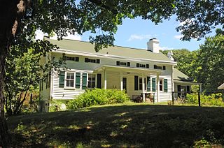
Ladentown United Methodist Church Historic Church 1865 (NRHP) ![]()
Ladentown is a hamlet in the Town of Haverstraw Rockland County, New York, United States is located in the center of a triangle between Haverstraw, Pomona and Suffern and two miles west of Mount Ivy. It is located north-northwest of New York City.
Ladentown was named after Michel Leyden who was a nail cutter in the Ramapo works who sometimes spelt his name as Laden. He opened a trading store here which became one of the first industries in the county. The mountain people brought baskets, beer barrel hoops, bowls, chairs, ladles and spoons they made from the wood and reeds found in the mountain to Laden's store to sell or take to New York City to be sold.
In 1836, Mr. Leyden sold his store to John J. Secor, but he still took his woodenware to New York City to sell.
The area, prior to its naming, was settled by Quaker families.
Ladentown United Methodist Church Historic Church 1865 (NRHP) ![]()
Municipalities and communities of Rockland County, New York, United States | ||
|---|---|---|
| Towns |  | |
| Villages | ||
| CDPs | ||
| Other hamlets | ||

Rockland County is the southernmost county on the west side of the Hudson River in the U.S. state of New York, part of the New York City metropolitan statistical area. It is a suburb of New York City that is about 6 miles from the Bronx at their closest points. The county's population, as of the 2020 United States Census, is 338,329, making it the third-most densely populated county outside New York City within New York. The county seat is New City. Rockland County is accessible via the New York State Thruway, which crosses the Hudson to Westchester at the Tappan Zee Bridge ten exits up from the Bronx, as well as the Palisades Parkway five exits up from the George Washington Bridge. The county's name derives from "rocky land", as the area has been aptly described, largely due to the Hudson River Palisades.

Congers is a suburban hamlet and census-designated place in the town of Clarkstown, Rockland County, New York, United States. It is located north of Valley Cottage, east of New City, across Lake DeForest, south of Haverstraw, and west of the Hudson River. It lies 19 miles (31 km) north of New York City's Bronx boundary. As of the 2010 census, the CDP population was 8,363.

Mount Ivy is a hamlet and census-designated place in the Town of Haverstraw, New York, United States. It is located north of New City, east of Pomona, south of Thiells, and west of Garnerville. The population was 6,878 at the 2010 census.

New City is a hamlet and census-designated place in the town of Clarkstown, Rockland County, New York, United States, part of the New York Metropolitan Area. An affluent suburb of New York City, the hamlet is located 18 miles (29 km) north of the city at its closest point, Riverdale, Bronx. Within Rockland County, New City is located north of Bardonia, northeast of Nanuet, east of New Square and New Hempstead, south of Garnerville and Haverstraw village, and west, straight across Lake DeForest, of Congers. New City's population was 33,559 at the 2010 census, making it the 14th most populous CDP/hamlet in the state of New York.

New Hempstead is a village in the town of Ramapo, Rockland County, New York, United States. It is located north of New Square, east of Wesley Hills, south of Pomona, and west of New City. The population was 5,132 at the 2010 census.
Pomona is a village partly in the town of Ramapo and partly in the town of Haverstraw in Rockland County, New York, United States. It is located north of New Hempstead, east of Harriman State Park, north of Monsey and west of Mount Ivy. According to the 2010 Census, the population was 3,103, a 13 percent increase from the 2000 figure of 2,726.

Spring Valley is a suburb of New York City, a village in the towns of Ramapo and Clarkstown in Rockland County, New York, United States. It is located north of Chestnut Ridge, east of Airmont and Monsey, south of Hillcrest, and west of Nanuet. The population was 33,066 at the 2020 census, making it the 2nd most populous community in Rockland County, after New City.

Thiells, known as Thiell's Corner in the 1850s, is a hamlet and census-designated place (CDP) in the town of Haverstraw, Rockland County, New York, United States. It is located north of Mount Ivy, east of Pomona, south of Tomkins Cove, and west of Garnerville. The population was 5,032 as of the 2010 census.

West Haverstraw is a village incorporated in 1883 in the town of Haverstraw, Rockland County, New York, United States. It is located northwest of Haverstraw village, east of Thiells, south of the hamlet of Stony Point, and west of the Hudson River. The population was 10,165 at the 2010 census. The majority of the hamlet of Garnerville is contained in the village of West Haverstraw.

Haverstraw is a village incorporated in 1854 in the town of Haverstraw in Rockland County, New York, United States. It is located north of Congers, southeast of West Haverstraw, east of Garnerville, northeast of New City, and west of the Hudson River at its widest point. According to the 2019 U.S. Census estimate, the population was 12,045, an increase from the 2010 Census population of 11,910.
Haverstraw is a town in Rockland County, New York, United States, located north of the Town of Clarkstown and the Town of Ramapo; east of Orange County, New York; south of the Town of Stony Point; and west of the Hudson River. The town runs from the west to the east border of the county in its northern part. The population was 36,634 at the 2010 census. The name comes from the Dutch word Haverstroo meaning "oats straw", referring to the grasslands along the river. The town contains three villages, one of which is also known as Haverstraw. Haverstraw village is the original seat of government for the town, hosting the area's historic central downtown business district and the densest population in northern Rockland County.

Rockland Lake State Park is a 1,133-acre (4.59 km2) state park located in the hamlets of Congers and Valley Cottage in the eastern part of the Town of Clarkstown in Rockland County, New York. The park is located on a ridge of Hook Mountain above the west bank of the Hudson River. Included within the park is the 256-acre (1.04 km2) Rockland Lake.
Garnerville, previously known as Calicotown, is a hamlet in the Town of Haverstraw, Rockland County, New York, United States located north of New City; east of Mount Ivy; south of Stony Point and west of West Haverstraw. Most of the Hamlet is governed by West Haverstraw Village, a small portion of Garnerville defaults to Town of Haverstraw.

Doodletown was an isolated hamlet in the Town of Stony Point, Rockland County, New York, United States. Purchased by the Palisades Interstate Park Commission during the 1960s, it is now part of Bear Mountain State Park and a popular destination for hikers, birdwatchers, botanists, and local historians. It is located north of Jones Point, west of Iona Island, and southeast of Orange County. The former settlement is now a ghost town.
Centenary is a neighborhood in New City, New York, the county seat of Rockland County. Located on the north-easternmost side of the hamlet, just south of Haverstraw, southeast of High Tor State Park, northwest of Dr. Davis Farm, and northeast of the neighborhood of Brownsell Corner. It is one of the most rural parts of New City.
The Mahwah River is a tributary of the Ramapo River in Rockland County, New York and Bergen County, New Jersey in the United States.
Tallman is a hamlet in the town of Ramapo, Rockland County, New York, United States, located north of the state of New Jersey; east of Suffern; south of Montebello and west of Airmont. It is located north-northwest of New York City.
Grassy Point, was a hamlet on the west side of the Hudson River, in the Town of Stony Point in Rockland County, New York, United States. It was located north of West Haverstraw; east of Harriman State Park; south of Stony Point.
The recorded history of Rockland County, New York begins on February 23, 1798, when the county was split off from Orange County, New York and formed as its own administrative division of the state of New York. It is located 6 miles (9.7 km) north-northwest of New York City, and is part of the New York Metropolitan Area. The county seat is the hamlet of New City. The name comes from rocky land, an early description of the area given by settlers. Rockland is New York's southernmost county west of the Hudson River. It is suburban in nature, with a considerable amount of scenic designated parkland. Rockland County does not border any of the New York City boroughs, but is only 9.5 miles (15.3 km) north of Manhattan at the counties' two respective closest points
Hook Mountain State Park is a 676-acre (2.74 km2) undeveloped state park located in Rockland County, New York. The park includes a portion of the Hudson River Palisades on the western shore of the Hudson River, and is part of the Palisades Interstate Park system. Hook Mountain State Park is functionally part of a continuous complex of parks that also includes Rockland Lake State Park, Nyack Beach State Park, and Haverstraw Beach State Park.