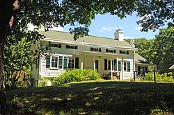
Pomona, New York

Last updated

Pomona, New York
Incorporated Village of Pomona
Rockland County New York incorporated and unincorporated areas Pomona highlighted.svg
Location in Rockland County and the state of New York.
USA New York location map.svg
Red pog.svg
Pomona, New York
Location within the state of New York
Coordinates: 41°11′11″N74°3′20″W / 41.18639°N 74.05556°W / 41.18639; -74.05556
Country Flag of the United States.svg  United States
State Flag of New York.svg  New York
County Rockland
Incorporated February 3, 1967
Government
  MayorIlan Fuchs
  Deputy MayorMendy Lasker
  TrusteesMarc Greenberg, Raanan Zidile, Joel Grunwald
Area
[1]
  Total
2.40 sq mi (6.21 km2)
  Land2.40 sq mi (6.21 km2)
  Water0.00 sq mi (0.00 km2)
Elevation
453 ft (138 m)
Population
 (2020)
  Total
3,824
  Density1,594.00/sq mi (615.56/km2)
Time zone UTC-5 (Eastern (EST))
  Summer (DST) UTC-4 (EDT)
ZIP code
10970
Area code 845
FIPS code 36-58992
GNIS feature ID0960875
Website www.pomonavillage.com

Pomona is a village partly in the town of Ramapo and partly in the town of Haverstraw in Rockland County, New York, United States. It is located north of New Hempstead, east of Harriman State Park, north of Monsey and west of Mount Ivy. According to the 2020 Census, the population was 3,824, [2] a 23 percent increase from the 2010 figure of 3,103. [3]

Contents

History

The village of Pomona was incorporated February 3, 1967, within the towns of Ramapo and Haverstraw. [4] Actor Burgess Meredith provided the seed money for the incorporation. [5] Pomona was named after the goddess of fruit trees, gardens, and orchards, for the area's many apple orchards.

Geography

Pomona is located at 41°11′11″N74°3′20″W / 41.18639°N 74.05556°W / 41.18639; -74.05556 (41.186504, -74.055417). [6]

According to the United States Census Bureau, the village has a total area of 2.4 square miles (6.2 km2), 1.4 square miles (3.6 km2) of which is in the town of Haverstraw and 1.0 sq mi (2.6 km2) of which is in the town of Ramapo. All of Pomona's total area is land.

Demographics

Historical population
CensusPop.Note
1970 1,792
1980 2,42135.1%
1990 2,6117.8%
2000 2,7264.4%
2010 3,10313.8%
2020 3,82423.2%
U.S. Decennial Census [7] [ failed verification ] 2020 [2]

At the 2010 census there were 3,103 people, 1,011 households, and 863 families in the village. The population density was 1,292.92 inhabitants per square mile (499.20/km2). There were 1,054 housing units at an average density of 439.17 per square mile (169.56/km2). The racial makeup of the village was 66.0% white, 19.1% African American, 0.2% Native American, 9.3% Asian, 2.2% from other races, and 3.2% from two or more races. Hispanic or Latino of any race were 7.1%. [8]

Of the 1,011 households, 32.7% had children under the age of 18 living with them, 75.6% were married couples living together, 6.6% had a female householder with no husband present, and 14.6% were non-families. 10.7% of households were one person and 3.6% were one person aged 65 or older. The average household size was 3.01 and the average family size was 3.22.

The age distribution was 24.2% age 19 and under, 4.4% from 20 to 24, 20.6% from 25 to 44, 35.0% from 45 to 64, and 15.9% 65 or older. The median age was 45.5 years. For every 100 females, there were 99.2 males. For every 100 females age 18 and over, there were 97.8 males.

The median household income was $103,608 and the median family income was $108,399. Males had a median income of $72,857 versus $48,958 for females. The per capita income for the village was $43,946. About 1.5% of families and 2.0% of the population were below the poverty line, including 1.1% of those under age 18 and 7.1% of those age 65 or over.

Government

In March 2023, Ilan Fuchs, an adherent of the Chabad-Lubavitch movement within Hasidic Judaism, was elected Mayor of Pomona. Fuchs had already been serving on the Village's Board of Trustees, along with fellow Chabad-Lubavitch adherent Mendy Lasker. In the same election, three other Jews were elected as Trustees, joining Fuchs and Lasker–Marc Greenberg, Mendy Lasker, Raanan Zidile and Joel Grunwald. [9] [10]

Fuchs' predecessor as Mayor was Ian Banks, who declined to run for re-election. [10] Ian Banks was elected in March 2019, along with Ilan Fuchs as one of his running mates; his predecessor was Brett Yagel, who in 2019 declined to run for re-election. [11]

Historical markers

Pig Knoll School PIG KNOLL SCHOOL, POMONA, ROCKLAND COUNTY, NY.jpg
Pig Knoll School
Ladentown United Methodist Church LADENTOWN UNITED METHODIST CHURCH, ROCKLAND COUNTY NY.jpg
Ladentown United Methodist Church
Pomona Village Hall CAMP HILL SCHOOL, ROCKLAND COUNTY, NY.jpg
Pomona Village Hall
Seaman-Knapp House Circa 1799 Greek Revival Style SEAMAN-KNAPP HOUSE, POMONA, ROCKLAND COUNTY MY.jpg
Seaman-Knapp House Circa 1799 Greek Revival Style

Landmarks and places of interest

Clover Stadium Provident Bank Ballpark.JPG
Clover Stadium
Seaman-Knapp House - 1799 Greek Revival Style SEAMAN-KNAPP HOUSE, POMONA, ROCKLAND COUNTY MY.jpg
Seaman-Knapp House - 1799 Greek Revival Style


Parks

Sports

Related Research Articles

<span class="mw-page-title-main">Rockland County, New York</span> County in New York, United States

Rockland County is the southernmost county on the west side of the Hudson River in the U.S. state of New York. It is part of the New York metropolitan area. As of the 2020 U.S. census, the county's population is 338,329, making it the state's third-most densely populated county outside New York City after Nassau and neighboring Westchester Counties. The county seat and largest hamlet is New City. Rockland County is accessible via both the New York State Thruway, which crosses the Hudson River to Westchester via the Tappan Zee Bridge over the Tappan Zee, ten exits up from the NYC border; and the Palisades Parkway, four exits up, via the George Washington Bridge. The county's name derives from "rocky land", as the area has been aptly described, largely due to the Hudson River Palisades. The county is part of the Hudson Valley region of the state.

<span class="mw-page-title-main">Airmont, New York</span> Village in New York, United States

Airmont is a village in the town of Ramapo, Rockland County, New York, United States, located north of the state of New Jersey, east of Suffern, south of Montebello, and west of Chestnut Ridge. The population was 10,166 at the 2020 census.

<span class="mw-page-title-main">Chestnut Ridge, New York</span> Village in New York, United States

Chestnut Ridge is a village in the town of Ramapo, Rockland County, New York, United States, located north of the state of New Jersey, east of Airmont, south of Spring Valley, and west of Nanuet. The population was 10,505 at the 2020 census.

<span class="mw-page-title-main">Clarkstown, New York</span> Town in New York, United States

Clarkstown is a town in Rockland County, New York, United States. The town is on the eastern border of the county, located north of the town of Orangetown, east of the town of Ramapo, south of the town of Haverstraw, and west of the Hudson River. As of the 2020 census, the town had a total population of 86,855. The hamlet of New City, the county seat of Rockland County, is also the seat of town government and of the Clarkstown Police Department, the county sheriff's office, and the county correctional facility. New City makes up about 41.47% of the town's population.

<span class="mw-page-title-main">Hillburn, New York</span> Village in New York, United States

Hillburn, originally called "Woodburn" and incorporated in 1893, is a village in the town of Ramapo, Rockland County, New York, United States. It is located north of Suffern, east of Orange County, south of Viola, and west of Montebello. It is considered to be one of the more rural communities in Rockland County. The population was 930 at the 2020 census.

<span class="mw-page-title-main">Hillcrest, Rockland County, New York</span> Census-designated place in New York, United States

Hillcrest is a hamlet incorporated in 1893 and census-designated place, in the town of Ramapo, Rockland County, New York, United States. It is located north of Spring Valley, east of Viola, south of New Square and New Hempstead, and west of New City. The population was 8,164 at the 2020 census.

<span class="mw-page-title-main">Montebello, New York</span> Village in New York, United States

Montebello is an incorporated village in Ramapo, Rockland County, New York, United States. It is located north of Suffern, east of Hillburn, south of Wesley Hills, and west of Airmont. The population was 4,507 at the 2020 census.

<span class="mw-page-title-main">Mount Ivy, New York</span> Census-designated place in New York, United States

Mount Ivy is a hamlet and census-designated place in the Town of Haverstraw, in Rockland County, New York, United States. It is located north of New City, east of Pomona, south of Thiells, and west of Garnerville. The population was 6,878 at the 2010 census.

<span class="mw-page-title-main">New Hempstead, New York</span> Village in New York, United States

New Hempstead is a village in the town of Ramapo, Rockland County, New York, United States. It is located north of New Square, east of Wesley Hills, south of Pomona, and west of New City. As of July 2023, the United States Census Bureau estimated the population as 5,419. Residents utilize the Spring Valley and New City post offices.

<span class="mw-page-title-main">Ramapo, New York</span> Town in New York, United States

Ramapo is a town in Rockland County, New York, United States. It was originally formed as New Hampstead, in 1791, and became Ramapo in 1828. It shares its name with the Ramapo River. As of the 2020 census, Ramapo had a total population of 148,919, making it the most populous town in New York outside of Long Island. If all towns in New York were cities, Ramapo would be the 12th-largest city in the state of New York.

<span class="mw-page-title-main">Spring Valley, New York</span> Village in Rockland County, New York, United States

Spring Valley is a village in the town of Ramapo and Clarkstown in Rockland County, New York, United States. It is located north of Chestnut Ridge, east of Airmont and Monsey, south of Hillcrest, and west of Nanuet. The population was 33,066 at the 2020 census, making it the second most populous community in both Clarkstown and Rockland County, after New City.

<span class="mw-page-title-main">Suffern, New York</span> Village in New York, United States

Suffern is a village that was incorporated in 1796 in the town of Ramapo in Rockland County, New York. Sitting adjacent to the town of Mahwah, New Jersey, Suffern is located 31 miles northwest of Manhattan. As of the 2020 census, Suffern's population was 11,402.

<span class="mw-page-title-main">Thiells, New York</span> Census-designated place in New York, United States

Thiells, known as Thiell's Corner in the 1850s, is a hamlet and census-designated place (CDP) in the town of Haverstraw, Rockland County, New York, United States. It is located north of Mount Ivy, east of Pomona, south of Tomkins Cove, and west of Garnerville. The population was 5,240 as of the 2020 census.

<span class="mw-page-title-main">Viola, New York</span> Census-designated place in New York, United States

Viola is a hamlet and census-designated place in the town of Ramapo, Rockland County, New York, United States. It is located north of Airmont, east of Montebello, south of Wesley Hills, and west of Hillcrest. The population was 6,868 at the 2010 census.

<span class="mw-page-title-main">Wesley Hills, New York</span> Village in New York, United States

Wesley Hills is a village in the town of Ramapo, Rockland County, New York, United States. It is located north of Viola, east of Harriman State Park, south of Pomona, and west of New Hempstead. The population was 5,628 at the 2010 census.

<span class="mw-page-title-main">West Haverstraw, New York</span> Village in New York, United States

West Haverstraw is a village incorporated in 1883 in the town of Haverstraw, Rockland County, New York, United States. It is located northwest of Haverstraw village, east of Thiells, south of the hamlet of Stony Point, and west of the Hudson River. The population was 10,165 at the 2010 census. The majority of the hamlet of Garnerville is contained in the village of West Haverstraw.

<span class="mw-page-title-main">Haverstraw (village), New York</span> Village in New York, United States

Haverstraw is a village incorporated in 1854 in the town of Haverstraw in Rockland County, New York, United States. It is located north of Congers, southeast of West Haverstraw, east of Garnerville, northeast of New City, and west of the Hudson River at its widest point. As of the 2020 census, the population was 12,323.

<span class="mw-page-title-main">Haverstraw, New York</span> Town in New York, United States

Haverstraw is a town in Rockland County, New York, United States, located north of the Town of Clarkstown and the Town of Ramapo; east of Orange County; south of the Town of Stony Point; and west of the Hudson River. The town runs from the west to the east border of the county in its northern section. The population was 39,087 at the 2020 census.

<span class="mw-page-title-main">New York State Route 306</span> State highway in Rockland County, New York, US

New York State Route 306 (NY 306) is a north–south state highway in western Rockland County, New York, in the United States. NY 306 runs from NY 59 in the hamlet of Monsey to U.S. Route 202 (US 202) in Ladentown, on the western boundary of the village of Pomona. The road is currently 5.33 miles (8.58 km) long; however, it originally extended south to the New Jersey state line and north to Willow Grove Road when it was assigned as part of the 1930 renumbering of state highways in New York.

The recorded history of Rockland County, New York begins on February 23, 1798, when the county was split off from Orange County, New York and formed as its own administrative division of the state of New York. It is located 6 miles (9.7 km) north-northwest of New York City, and is part of the New York Metropolitan Area. The county seat is the hamlet of New City. The name comes from rocky land, an early description of the area given by settlers. Rockland is New York's southernmost county west of the Hudson River. It is suburban in nature, with a considerable amount of scenic designated parkland. Rockland County does not border any of the New York City boroughs, but is only 9.5 miles (15.3 km) north of Manhattan at the counties' two respective closest points

References

  1. "ArcGIS REST Services Directory". United States Census Bureau. Retrieved September 20, 2022.
  2. 1 2 "Pomona village, New York". census.gov. Retrieved January 1, 2022.
  3. Santos, Robert (2010). "census.gov".
  4. "About – Pomona Village" . Retrieved July 8, 2021.
  5. "Village of Pomona - Burgess Park". www.pomonavillage.com. Retrieved July 8, 2021.
  6. "US Gazetteer files: 2010, 2000, and 1990". United States Census Bureau. February 12, 2011. Retrieved April 23, 2011.
  7. "Census of Population and Housing". Census.gov. Retrieved June 4, 2015.
  8. "U.S. Census website". United States Census Bureau . Retrieved January 31, 2008.
  9. "Chabad Hasid Ilan Fuchs Elected Mayor in Rockland County, NY". March 23, 2023. Retrieved October 10, 2024.
  10. 1 2 Lieberman, Steve (March 23, 2023). "Village elections: Orthodox Jewish voters spearhead contested wins in Airmont and Pomona". The Journal News. Retrieved October 10, 2024.
  11. Goldblatt, Rochel Leah (March 20, 2019). "Rockland village elections: New leadership in Pomona, Airmont, incumbents win in Chestnut Ridge". The Journal News. Retrieved October 11, 2024.
  12. "Burgess Meredith Park – Pomona Village" . Retrieved July 8, 2021.
  13. "Secor Park – Pomona Village" . Retrieved December 16, 2021.
  14. "Van den Hende Park – Pomona Village" . Retrieved December 16, 2021.