Viola, New York

Last updated
Viola, New York
Viola NY.JPG
Winter In Viola
Rockland County New York incorporated and unincorporated areas Viola highlighted.svg
Location in Rockland County and the state of New York.
USA New York location map.svg
Red pog.svg
Viola, New York
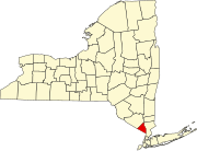
Location within the state of New York
Coordinates: 41°7′35″N74°5′0″W / 41.12639°N 74.08333°W / 41.12639; -74.08333 Coordinates: 41°7′35″N74°5′0″W / 41.12639°N 74.08333°W / 41.12639; -74.08333
Country United States
State New York
County Rockland
Area
[1]
  Total2.76 sq mi (7.16 km2)
  Land2.76 sq mi (7.16 km2)
  Water0.00 sq mi (0.00 km2)
Elevation
568 ft (173 m)
Population
 (2020)
  Total8,208
  Density2,969.61/sq mi (1,146.48/km2)
Time zone UTC-5 (Eastern (EST))
  Summer (DST) UTC-4 (EDT)
FIPS code 36-77574
GNIS feature ID0968565

Viola is a hamlet and census-designated place in the town of Ramapo, Rockland County, New York, United States. It is located north of Airmont, east of Montebello, south of Wesley Hills, and west of Hillcrest. The population was 6,868 at the 2010 census. [2]

Contents

History

Alms House

Daniel T. Brucker Hall, Rockland Community College SUNYRCC1.jpg
Daniel T. Brucker Hall, Rockland Community College

The Alms House (or County Poor House) was established in 1837, at Viola (then known as Mechanicsville) in the town of Ramapo, for the poor and destitute (debtors). It was located 7 miles (11 km) west of New City. Rockland County had purchased the 47-acre (190,000 m2) parsonage farm of the Kakiat (West New Hempstead) Dutch Reformed Church (also known as the Brick Church) for use as an alms house. There the county originally built a wooden frame house to serve the poor. The inmates contributed to their upkeep by tending the farm. In 1883, a brick building was constructed. The facility included a school for the children. In 1957, the Alms House was moved to Building "C" at the Pomona Health Center in Summit Park, and the property would become the site of Rockland Community College. The Alms House was renamed the Rockland County Infirmary and Home. In 1977, it was removed to Building "A". It has been renamed the Summit Park Nursing Care Center. The old brick Alms House building remains as an administration building (Daniel T. Brucker Hall), used by Rockland Community College. The farm lands are the campus. The Poor Cemetery (Potter's Field) remains on the RCC campus, along with the original Gary Onderdonk Veterans' Cemetery.

Geography

Viola is located at 41°7′35″N74°5′0″W / 41.12639°N 74.08333°W / 41.12639; -74.08333 (41.126295, -74.083285). [3]

According to the United States Census Bureau, the CDP has a total area of 2.7 square miles (7.0 km2), all land.

Demographics

Historical population
CensusPop.
2020 8,208
U.S. Decennial Census [4]

As of the census [5] of 2000, there were 5,931 people, 1,681 households, and 1,250 families residing in the CDP. The population density was 2,192.4 per square mile (845.0/km2). There were 1,738 housing units at an average density of 642.4/sq mi (247.6/km2). The racial makeup of the CDP was 97.81% White, 0.32% African American, 0.05% Native American, 0.67% Asian, 0.07% Pacific Islander, 0.46% from other races, and 0.62% from two or more races. Hispanic or Latino of any race were 2.61% of the population.

There were 1,681 households, out of which 40.7% had children under the age of 18 living with them, 68.7% were married couples living together, 4.1% had a female householder with no husband present, and 25.6% were non-families. 24.4% of all households were made up of individuals, and 20.6% had someone living alone who was 65 years of age or older. The average household size was 3.53 and the average family size was 4.34.

In the CDP, the population was spread out, with 39.9% under the age of 18, 8.3% from 18 to 24, 17.6% from 25 to 44, 18.9% from 45 to 64, and 15.3% who were 65 years of age or older. The median age was 28 years. For every 100 females, there were 92.4 males. For every 100 females age 18 and over, there were 87.2 males.

The median income for a household in the CDP was $59,821, and the median income for a family was $87,273. Males had a median income of $68,533 versus $39,375 for females. The per capita income for the CDP was $27,289. About 4.9% of families and 6.5% of the population were below the poverty line, including 6.3% of those under age 18 and 9.6% of those age 65 or over.

Education

East Ramapo Central School District and Suffern Central School District (formerly Ramapo Central) serve portions of Viola. [6]

Related Research Articles

<span class="mw-page-title-main">Wyola, Montana</span> Census-designated place in Montana, United States

Wyola is a census-designated place (CDP) in Big Horn County, Montana, United States. The population was 215 at the 2010 census. 79% of the residents are Native American, and the majority are members of the Crow Nation.

<span class="mw-page-title-main">Airmont, New York</span> Village in New York, United States

Airmont is a village in the town of Ramapo, Rockland County, New York, United States, located north of the state of New Jersey, east of Suffern, south of Montebello, and west of Chestnut Ridge. The population was 8,628 at the 2010 census.

<span class="mw-page-title-main">Bardonia, New York</span> Hamlet & CDP in New York, United States

Bardonia is a hamlet and census-designated place in the town of Clarkstown, Rockland County, New York, United States. It is located northeast of Nanuet, northwest of West Nyack, south of New City, and west of Valley Cottage. The population was 4,108 at the 2010 census.

<span class="mw-page-title-main">Hillburn, New York</span> Village in New York, United States

Hillburn, originally called "Woodburn" and incorporated in 1893, is a village in the town of Ramapo, Rockland County, New York, United States. It is located north of Suffern, east of Orange County, south of Viola, and west of Montebello. It is considered to be one of the more rural communities in Rockland County. The population was 951 at the 2010 census.

<span class="mw-page-title-main">Hillcrest, Rockland County, New York</span> Census-designated place in New York, United States

Hillcrest is a hamlet incorporated in 1893 and census-designated place, in the town of Ramapo, Rockland County, New York, United States. It is located north of Spring Valley, east of Viola, south of New Square and New Hempstead, and west of New City. The population was 8,164 at the 2020 census.

<span class="mw-page-title-main">Kaser, New York</span> Village in New York, United States

Kaser is a village in the town of Ramapo, Rockland County, New York, United States. The village is completely surrounded by the hamlet of Monsey. As of the 2020 United States census, the village population was 5,491.

<span class="mw-page-title-main">Monsey, New York</span> CDP in New York, United States

Monsey is a hamlet and census-designated place in the town of Ramapo, Rockland County, New York, United States, located north of Airmont, east of Viola, south of New Hempstead, and west of Spring Valley. The village of Kaser is surrounded by the hamlet of Monsey. The 2020 census listed the population at 26,954.

<span class="mw-page-title-main">Mount Ivy, New York</span> Census-designated place in New York, United States

Mount Ivy is a hamlet and census-designated place in the Town of Haverstraw, in Rockland County, New York, United States. It is located north of New City, east of Pomona, south of Thiells, and west of Garnerville. The population was 6,878 at the 2010 census.

<span class="mw-page-title-main">Nanuet, New York</span> Census-designated place in New York, United States

Nanuet is a hamlet and census-designated place in the town of Clarkstown, Rockland County, New York, United States. The third largest hamlet in Clarkstown, it is located north of Pearl River, south of New City, east of Spring Valley, and west of West Nyack. It is located midway between Manhattan and Bear Mountain, 19 miles (31 km) north and south of each respectively; and 2 miles (3 km) north of the New Jersey border. It has one of three Rockland County stations on New Jersey Transit's Pascack Valley Line. The population of Nanuet was 17,882 at the 2010 census.

<span class="mw-page-title-main">New Hempstead, New York</span> Village in New York, United States

New Hempstead is a village in the town of Ramapo, Rockland County, New York, United States. It is located north of New Square, east of Wesley Hills, south of Pomona, and west of New City. The population was 5,132 at the 2010 census. Residents utilize the Spring Valley and New City post offices.

<span class="mw-page-title-main">New Square, New York</span> Village in New York, United States

New Square is an all-Hasidic village in the town of Ramapo, Rockland County, New York, United States. It is located north of Hillcrest, east of Viola, south of New Hempstead, and west of New City. As of the 2020 United States census, it had a population of 9,679. Its inhabitants are predominantly members of the Skverer Hasidic movement who seek to maintain a Hasidic lifestyle disconnected from the secular world. It is the poorest town in New York, and the eighth poorest in the United States. It also has the highest poverty rate, at 64.4%.

<span class="mw-page-title-main">Pomona, New York</span> Village in New York, United States

Pomona is a village partly in the town of Ramapo and partly in the town of Haverstraw in Rockland County, New York, United States. It is located north of New Hempstead, east of Harriman State Park, north of Monsey and west of Mount Ivy. According to the 2020 Census, the population was 3,824, a 23 percent increase from the 2010 figure of 3,103.

<span class="mw-page-title-main">Ramapo, New York</span> Town in New York, United States

Ramapo is a town in Rockland County, New York, United States. It was originally formed as New Hampstead, in 1791, and became Ramapo in 1828. It shares its name with the Ramapo River. As of the 2020 census, Ramapo had a total population of 148,919, making it the most populous town in New York outside of Long Island. If Ramapo were incorporated as a city, it would be the sixth-largest city in the state of New York.

<span class="mw-page-title-main">Sloatsburg, New York</span> Village in Ramapo, New York, US

Sloatsburg is a village in the town of Ramapo in Rockland County, New York, United States. Located east of Orange County, it is at the southern entrance to Harriman State Park. The population was 3,039 at the 2010 census. The village is named after Stephen Sloat, an early European landowner.

<span class="mw-page-title-main">Thiells, New York</span> Census-designated place in New York, United States

Thiells, known as Thiell's Corner in the 1850s, is a hamlet and census-designated place (CDP) in the town of Haverstraw, Rockland County, New York, United States. It is located north of Mount Ivy, east of Pomona, south of Tomkins Cove, and west of Garnerville. The population was 5,032 as of the 2010 census.

<span class="mw-page-title-main">Wesley Hills, New York</span> Village in New York, United States

Wesley Hills is a village in the town of Ramapo, Rockland County, New York, United States. It is located north of Viola, east of Harriman State Park, south of Pomona, and west of New Hempstead. The population was 5,628 at the 2010 census.

<span class="mw-page-title-main">Roscoe, New York</span> CDP in New York, United States

Roscoe is a hamlet in Sullivan County, New York, United States. The population was 541 at the 2010 census.

<span class="mw-page-title-main">Clintondale, New York</span> CDP in New York, United States

Clintondale is a hamlet in Ulster County, New York, United States. The population was 1,452 at the 2010 census.

<span class="mw-page-title-main">Tillson, New York</span> CDP in New York, United States

Tillson is a hamlet in Ulster County, New York, United States. The population was 1,586 at the 2010 census.

<span class="mw-page-title-main">Plattekill (CDP), New York</span> CDP in New York, United States

Plattekill is a hamlet in Ulster County, New York, United States. The population was 1,260 at the 2010 census. The community, as is the town, is named after a local stream, the Platte Kill.

References

  1. "ArcGIS REST Services Directory". United States Census Bureau. Retrieved September 20, 2022.
  2. "Profile of General Population and Housing Characteristics: 2010 Demographic Profile Data (DP-1): Viola CDP, New York". United States Census Bureau . Retrieved February 9, 2012.
  3. "US Gazetteer files: 2010, 2000, and 1990". United States Census Bureau. 2011-02-12. Retrieved 2011-04-23.
  4. "Census of Population and Housing". Census.gov. Retrieved June 4, 2016.
  5. "U.S. Census website". United States Census Bureau . Retrieved 2008-01-31.
  6. "SCHOOL DISTRICT REFERENCE MAP (2010 CENSUS): Rockland County, NY" (PDF). 2010 U.S. Census . U.S. Census Bureau . Retrieved 2019-11-05.