
Saranac is a town in Clinton County, New York, United States. The town is on the western border of the county, west of Plattsburgh, and is within the Adirondack Park. The population was 3,852 at the 2020 census, down from 4,007 at the 2010 census. The town is named for the Saranac River that flows through the town.

Fort Montgomery is a hamlet in Orange County, New York, United States. The population was 1,627 at the 2020 census. It is part of the Poughkeepsie–Newburgh–Middletown, NY Metropolitan Statistical Area as well as the larger New York–Newark–Bridgeport, NY-NJ-CT-PA Combined Statistical Area.

Nanuet is a hamlet and census-designated place in the town of Clarkstown, New York, United States. The third largest hamlet in Clarkstown, it is located north of Pearl River, south of New City, east of Spring Valley, and west of West Nyack. It is located midway between Manhattan and Bear Mountain, 19 miles (31 km) north and south of each respectively; and 2 miles (3 km) north of the New Jersey border. It has one of three Rockland County stations on New Jersey Transit's Pascack Valley Line. The population of Nanuet was 17,882 at the 2010 census.
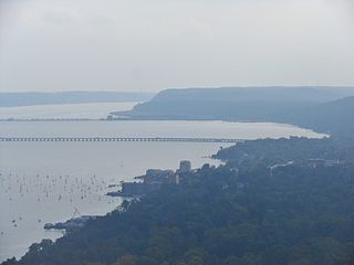
Orangetown is a town in Rockland County, New York, United States, located in the southeastern part of the county. It is northwest of New York City, north of New Jersey, east of the town of Ramapo, south of the town of Clarkstown, and west of the Hudson River. The population was 48,655 at the 2020 census.

Pearl River is a hamlet and census-designated place in the town of Orangetown, Rockland County, New York, United States. It is east of Chestnut Ridge, south of Nanuet, west of Blauvelt, New York, and north of Montvale and Old Tappan, New Jersey. The population was 15,876 at the 2010 census.

Tappan is a hamlet and census-designated place in the town of Orangetown, New York, United States. It is located northwest of Alpine, New Jersey, north of Northvale, New Jersey and Rockleigh, New Jersey, northeast of Old Tappan, New Jersey, east/southeast of Nauraushaun and Pearl River, south of Orangeburg, southwest of Sparkill, and west of Palisades; Tappan shares a border with each. The population was 6,673, according to the 2020 census.

Esopus is a town in Ulster County, New York, United States. The population was 9,548 at the 2020 census. The town was named after the local indigenous tribe and previously thought to mean "small river" in English. However, in the Lenape` language, the word translates to "Wellspring of Creation". The Esopus people were one of the Lenape (Delaware) bands, belonging to a people who ranged from western Connecticut through lower New York, western Long Island, and parts of New Jersey and Pennsylvania along the Delaware River. The town is on the west bank of the Hudson River south of the city of Kingston. Its center is in Port Ewen. US Route 9W passes along the eastern side of the town.

Rhinebeck is a town in Dutchess County, New York, United States. The population was 7,596 at the 2020 census. It is part of the Kiryas Joel-Poughkeepsie-Newburgh metropolitan area as well as the larger New York metropolitan area.
The Cross River is a short river that rises within the hamlet of Cross River in the town of Lewisboro in southern New York state. Its headwaters make a loop, heading south, then southwest, then northwest, and finally west, continuing a few miles in that direction until it joins a tendril of the Cross River Reservoir, a part of the New York City water supply system.
Tomkins Cove is a hamlet in the Town of Stony Point, Rockland County, New York, United States, located north of Stony Point; east of Harriman State Park; south of Doodletown and west of the Hudson River. It is located north-northwest of New York City. The population is approximately 1,739 and the ZIP Code is 10986. The community is served by the 786 exchange in area code 845.
Shekomeko was a historic hamlet in the southwestern part of the town of North East, New York, United States) in present-day Dutchess County. It was a village of the Mahican people. They lived by a stream which Anglo-Americans later named Shekomeko Creek, after their village. Shekomeko comes from Mahikanneuw and means "people of the place of eels ["linear fish"], from "shaxk" - linear, straight; "amek" = fish; = locative suffix "ink", + ethnonymial locative suffix "oik" - Shaxkaminkoik > Shekomeko.

Eastview is a business district and former hamlet in Mount Pleasant, Westchester County, New York, United States, located approximately 25 miles north of Midtown Manhattan. It was primarily residential, and had a post office, railroad station, and school. In the late 1920s, John D. Rockefeller Jr. purchased most of the hamlet's property and razed the buildings. The Hammond House, a National Register of Historic Places-listed farmhouse dating to the 1720s, is located in the district, on New York State Route 100C. Currently, dozens of commercial buildings have been developed in the area. The community is now most prominently known as the global headquarters for Regeneron Pharmaceuticals, which moved into a newly constructed campus in 2014.
Sickletown was a hamlet in the town of Orangetown in Rockland County, New York, United States. It was located north of Nauraushaun, east of the state of New Jersey, south of Nanuet, and west of Blauvelt.

The East Branch Croton River is a tributary of the Croton River in Dutchess, Putnam, and Westchester counties in the state of New York. It lies within the Croton River watershed and is part of the New York City water supply system's Croton Watershed.

Sparta is a neighborhood of the village of Ossining in Westchester County, New York, United States. Sparta borders the Hudson River, south of most of the village of Ossining. The neighborhood was a hamlet of the town of Ossining, and remains its oldest community. Sparta was founded by Dutch settlers in the 17th century. It has zip codes 10510 and 10562. The elevation is 56 feet.

Sodom is a hamlet in Putnam County, in the U.S. state of New York.
Kirk Lake is a controlled lake in the hamlet of Mahopac in the town of Carmel in Putnam County, New York. It lies due west and sharply below considerably larger Lake Mahopac. It is one of three controlled lakes in the New York City water supply system's Croton Watershed.
The West Branch Croton River is a tributary of the Croton River in Putnam and Westchester counties in the state of New York. It lies within the Croton River watershed and is part of the New York City water supply system's Croton Watershed.
The Middle Branch Croton River is a tributary of the Croton River in Putnam and Westchester counties in the state of New York. It lies within the Croton River watershed and is part of the New York City water supply system's Croton Watershed.
The Muscoot River is a short tributary of the Croton River in Putnam and Westchester counties in the state of New York. Approximately 6 mi (9.7 km) long and running north-to-south, it lies within the Croton River watershed and is part of the New York City water supply system's Croton Watershed.
