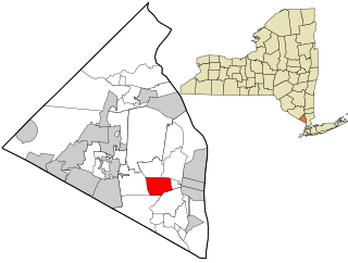
Demographics
Historical population| Census | Pop. | Note | %± |
|---|
| 1890 | 1,496 | | — |
|---|
| 1900 | 1,601 | | 7.0% |
|---|
| 1910 | 2,068 | | 29.2% |
|---|
| 1920 | 1,799 | | −13.0% |
|---|
| 1930 | 2,212 | | 23.0% |
|---|
| 1940 | 2,093 | | −5.4% |
|---|
| 1950 | 3,102 | | 48.2% |
|---|
| 1960 | 3,113 | | 0.4% |
|---|
| 1970 | 3,435 | | 10.3% |
|---|
| 1980 | 3,602 | | 4.9% |
|---|
| 1990 | 3,352 | | −6.9% |
|---|
| 2000 | 3,473 | | 3.6% |
|---|
| 2010 | 3,510 | | 1.1% |
|---|
| 2020 | 2,699 | | −23.1% |
|---|
|
As of the census [10] of 2000, there were 3,473 people, 1,201 households, and 690 families residing in the village. The population density was 5,665.0 inhabitants per square mile (2,187.3/km2). There were 1,258 housing units at an average density of 2,052.0 per square mile (792.3/km2). The racial makeup of the village was 71.32% White, 16.04% African American, 0.20% Native American, 5.79% Asian, 0.03% Pacific Islander, 2.39% from other races, and 4.23% from two or more races. Hispanic or Latino of any race were 6.91% of the population.
There were 1,201 households, out of which 26.9% had children under the age of 18 living with them, 45.1% were married couples living together, 9.2% had a female householder with no husband present, and 42.5% were non-families. 31.3% of all households were made up of individuals, and 8.4% had someone living alone who was 65 years of age or older. The average household size was 2.43 and the average family size was 3.10.
In the village, the population was spread out, with 18.3% under the age of 18, 20.5% from 18 to 24, 29.7% from 25 to 44, 20.8% from 45 to 64, and 10.8% who were 65 years of age or older. The median age was 32 years. For every 100 females, there were 94.8 males. For every 100 females age 18 and over, there were 89.3 males.
The median income for a household in the village was $53,000, and the median income for a family was $62,262. Males had a median income of $45,735 versus $39,850 for females. The per capita income for the village was $26,135. About 6.2% of families and 8.9% of the population were below the poverty line, including 8.4% of those under age 18 and 10.8% of those age 65 or over.

Rockland County is the southernmost county on the west side of the Hudson River in the U.S. state of New York. It is part of the New York metropolitan area. As of the 2020 U.S. census, the county's population is 338,329, making it the state's third-most densely populated county outside New York City after Nassau and neighboring Westchester counties. The county seat and largest hamlet is New City. Rockland County is accessible via both the New York State Thruway, which crosses the Hudson River to Westchester via the Tappan Zee Bridge over the Tappan Zee, ten exits up from the NYC border; and the Palisades Parkway, four exits up, via the George Washington Bridge. The county's name derives from "rocky land", as the area has been aptly described, largely due to the Hudson River Palisades. The county is part of the Hudson Valley region of the state.
Bardonia is a hamlet and census-designated place in the town of Clarkstown, Rockland County, New York, United States. It is located northeast of Nanuet, northwest of West Nyack, south of New City, and west of Valley Cottage. The population was 4,108 at the 2010 census.

Blauvelt is a hamlet, about 20 miles northwest of New York City. It is a census-designated place, formerly known as Greenbush and then Blauveltville, in Orangetown, Rockland County, New York, United States. It is located north of Tappan, east of Nauraushaun and Pearl River, south of Central Nyack, and west of Orangeburg. As of the 2010 census, the CDP had a population of 5,689.

Clarkstown is a town in Rockland County, New York, United States. The town is on the eastern border of the county, located north of the town of Orangetown, east of the town of Ramapo, south of the town of Haverstraw, and west of the Hudson River. As of the 2020 census, the town had a total population of 86,855. The hamlet of New City, the county seat of Rockland County, is also the seat of town government and of the Clarkstown Police Department, the county sheriff's office, and the county correctional facility. New City makes up about 41.47% of the town's population.
Grand View-on-Hudson is a village incorporated in 1918 in the town of Orangetown in Rockland County, New York, United States. It is located north of Piermont, east of Orangeburg, south of South Nyack, and west of the Hudson River. The population was 285 at the 2010 census. The name is derived from the scenic view from its location.

Hillcrest is a hamlet incorporated in 1893 and census-designated place, in the town of Ramapo, Rockland County, New York, United States. It is located north of Spring Valley, east of Viola, south of New Square and New Hempstead, and west of New City. The population was 8,164 at the 2020 census.

Nanuet is a hamlet and census-designated place in the town of Clarkstown, New York, United States. The third largest hamlet in Clarkstown, it is located north of Pearl River, south of New City, east of Spring Valley, and west of West Nyack. It is located midway between Manhattan and Bear Mountain, 19 miles (31 km) north and south of each respectively; and 2 miles (3 km) north of the New Jersey border. It has one of three Rockland County stations on New Jersey Transit's Pascack Valley Line. The population of Nanuet was 17,882 at the 2010 census.

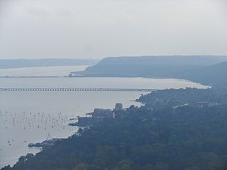
Nyack is a village located primarily in the town of Orangetown in Rockland County, New York, United States. Incorporated in 1872, it retains a very small western section in Clarkstown. The village had a population of 7,265 as of the 2020 census. It is a suburb of New York City lying approximately 15 miles (24 km) north of the Manhattan boundary near the west bank of the Hudson River, situated north of South Nyack, east of Central Nyack, south of Upper Nyack, and southeast of Valley Cottage.
Orangeburg is a hamlet and census-designated place, in the town of Orangetown, Rockland County, New York, United States. It is located north of Tappan, south of Blauvelt, east of Pearl River and west of Piermont. The population was 4,568 at the 2010 census.
Orangetown is a town in Rockland County, New York, United States, located in the southeastern part of the county. It is northwest of New York City, north of New Jersey, east of the town of Ramapo, south of the town of Clarkstown, and west of the Hudson River. The population was 48,655 at the 2020 census.

Piermont is a village incorporated in 1847 in Rockland County, New York, United States. Piermont is in the town of Orangetown, located north of the hamlet of Palisades, east of Sparkill, and south of Grand View-on-Hudson, on the west bank of the Hudson River. The population was 2,517 at the 2020 census. Woody Allen set The Purple Rose of Cairo (1984) in Piermont.

Tappan is a hamlet and census-designated place in the town of Orangetown, New York, United States. It is located northwest of Alpine, New Jersey, north of Northvale, New Jersey and Rockleigh, New Jersey, northeast of Old Tappan, New Jersey, east/southeast of Nauraushaun and Pearl River, south of Orangeburg, southwest of Sparkill, and west of Palisades; Tappan shares a border with each. The population was 6,673, according to the 2020 census.

Upper Nyack is a village incorporated in 1872 in the town of Clarkstown, Rockland County, New York, United States. It is located north of the village of Nyack, east of Valley Cottage, south of Rockland Lake State Park, and west of the Hudson River. The population was 2,063 at the 2010 census.

Valley Cottage is a hamlet and census-designated place in the town of Clarkstown, New York, United States. It is located northeast of West Nyack, northwest of Central Nyack east of Bardonia, south of Congers, northwest of Nyack, and west of Upper Nyack. The population was 9,107 at the 2010 census.

West Haverstraw is a village incorporated in 1883 in the town of Haverstraw, Rockland County, New York, United States. It is located northwest of Haverstraw village, east of Thiells, south of the hamlet of Stony Point, and west of the Hudson River. The population was 10,165 at the 2010 census. The majority of the hamlet of Garnerville is contained in the village of West Haverstraw.
West Nyack is a hamlet and census-designated place in the town of Clarkstown, Rockland County, New York, United States. It is located north of Blauvelt, east of Nanuet, southwest of Valley Cottage, southeast of Bardonia, and west of Central Nyack. It is approximately 18 miles (29 km) north of New York City. The population was 3,439 at the 2010 census.

Greenburgh is a town in western Westchester County, New York. The population was 95,397 at the time of the 2020 census. The town consists of 6 villages and an unincorporated area.
Haverstraw is a town in Rockland County, New York, United States, located north of the Town of Clarkstown and the Town of Ramapo; east of Orange County; south of the Town of Stony Point; and west of the Hudson River. The town runs from the west to the east border of the county in its northern section. The population was 39,087 at the 2020 census.

Sparkill, formerly known as Tappan Sloat, is a suburban hamlet and census-designated place in the Town of Orangetown, Rockland County, New York, United States located north of Palisades; east of Tappan; south of Piermont and west of the Hudson River. As of the 2010 census, the CDP had a population of 1,565. The hamlet is home to St. Thomas Aquinas College and the Dominican Sisters of Sparkill.
The recorded history of Rockland County, New York begins on February 23, 1798, when the county was split off from Orange County, New York and formed as its own administrative division of the state of New York. It is located 6 miles (9.7 km) north-northwest of New York City, and is part of the New York Metropolitan Area. The county seat is the hamlet of New City. The name comes from rocky land, an early description of the area given by settlers. Rockland is New York's southernmost county west of the Hudson River. It is suburban in nature, with a considerable amount of scenic designated parkland. Rockland County does not border any of the New York City boroughs, but is only 9.5 miles (15.3 km) north of Manhattan at the counties' two respective closest points