
Rockland County is the southernmost county on the west side of the Hudson River in the U.S. state of New York. It is part of the New York metropolitan area. As of the 2020 U.S. census, the county's population is 338,329, making it the state's third-most densely populated county outside New York City after Nassau and neighboring Westchester Counties. The county seat and largest hamlet is New City. Rockland County is accessible via the New York State Thruway, which crosses the Hudson River to Westchester at the Tappan Zee Bridge over the Tappan Zee, ten exits up from the NYC border, as well as the Palisades Parkway five exits up from the George Washington Bridge. The county's name derives from "rocky land", as the area has been aptly described, largely due to the Hudson River Palisades. The county is part of the Hudson Valley region of the state.
Bardonia is a hamlet and census-designated place in the town of Clarkstown, Rockland County, New York, United States. It is located northeast of Nanuet, northwest of West Nyack, south of New City, and west of Valley Cottage. The population was 4,108 at the 2010 census.

Clarkstown is a town in Rockland County, New York, United States. The town is on the eastern border of the county, located north of the town of Orangetown, east of the town of Ramapo, south of the town of Haverstraw, and west of the Hudson River. As of the 2020 census, the town had a total population of 86,855. The hamlet of New City, the county seat of Rockland County, is also the seat of town government and of the Clarkstown Police Department, the county sheriff's office, and the county correctional facility. New City makes up about 41.47% of the town's population.
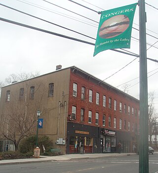
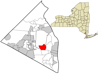
Congers is a suburban hamlet and census-designated place in the town of Clarkstown, Rockland County, New York, United States. It is located north of Valley Cottage, east of New City, across Lake DeForest, south of Haverstraw, and west of the Hudson River. It lies 19 miles (31 km) north of New York City's Bronx boundary. As of the 2020 census, the population was 8,532.

Hillcrest is a hamlet incorporated in 1893 and census-designated place, in the town of Ramapo, Rockland County, New York, United States. It is located north of Spring Valley, east of Viola, south of New Square and New Hempstead, and west of New City. The population was 8,164 at the 2020 census.

Nanuet is a hamlet and census-designated place in the town of Clarkstown, New York, United States. The third largest hamlet in Clarkstown, it is located north of Pearl River, south of New City, east of Spring Valley, and west of West Nyack. It is located midway between Manhattan and Bear Mountain, 19 miles (31 km) north and south of each respectively; and 2 miles (3 km) north of the New Jersey border. It has one of three Rockland County stations on New Jersey Transit's Pascack Valley Line. The population of Nanuet was 17,882 at the 2010 census.

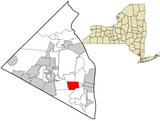
New City is a hamlet and census-designated place in the town of Clarkstown, Rockland County, New York, United States, part of the New York Metropolitan Area. An affluent suburb of New York City, the hamlet is located 18 miles (29 km) north of the city at its closest point, Riverdale, Bronx. Within Rockland County, New City is located north of Bardonia, northeast of Nanuet, east of New Square and New Hempstead, south of Garnerville and the village of Haverstraw, and west of Congers. New City's population was 35,101 at the 2020 census, making it the 14th most populous CDP/hamlet in the state of New York.

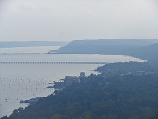
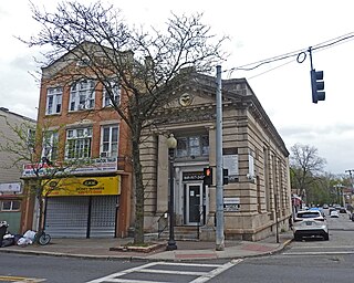
Nyack is a village located primarily in the town of Orangetown in Rockland County, New York, United States. Incorporated in 1872, it retains a very small western section in Clarkstown. The village had a population of 7,265 as of the 2020 census. It is a suburb of New York City lying approximately 15 miles (24 km) north of the Manhattan boundary near the west bank of the Hudson River, situated north of South Nyack, east of Central Nyack, south of Upper Nyack, and southeast of Valley Cottage.
Orangetown is a town in Rockland County, New York, United States, located in the southeastern part of the county. It is northwest of New York City, north of New Jersey, east of the town of Ramapo, south of the town of Clarkstown, and west of the Hudson River. The population was 48,655 at the 2020 census.

South Nyack is a hamlet and census-designated place in the town of Orangetown in Rockland County, New York, United States. It is located north of Grand View-on-Hudson, northeast of Orangeburg, east of Blauvelt State Park, south of Nyack and west of the Hudson River. The hamlet is the western terminus of the Tappan Zee Bridge. Its population was 3,510 at the 2010 census. The hamlet was formerly incorporated as a village from 1878 until 2022.
Spring Valley is a village in the town of Ramapo and Clarkstown in Rockland County, New York, United States. It is located north of Chestnut Ridge, east of Airmont and Monsey, south of Hillcrest, and west of Nanuet. The population was 33,066 at the 2020 census, making it the second most populous community in both Clarkstown and Rockland County, after New City.

Valley Cottage is a hamlet and census-designated place in the town of Clarkstown, New York, United States. It is located northeast of West Nyack, northwest of Central Nyack east of Bardonia, south of Congers, northwest of Nyack, and west of Upper Nyack. The population was 9,107 at the 2010 census.
West Nyack is a hamlet and census-designated place in the town of Clarkstown, Rockland County, New York, United States. It is located north of Blauvelt, east of Nanuet, southwest of Valley Cottage, southeast of Bardonia, and west of Central Nyack. It is approximately 18 miles (29 km) north of New York City. The population was 3,439 at the 2010 census.

Haverstraw is a village incorporated in 1854 in the town of Haverstraw in Rockland County, New York, United States. It is located north of Congers, southeast of West Haverstraw, east of Garnerville, northeast of New City, and west of the Hudson River at its widest point. As of the 2020 census, the population was 12,323.

Rockland Lake State Park is a 1,133-acre (4.59 km2) state park located in the hamlets of Congers and Valley Cottage in the eastern part of the Town of Clarkstown in Rockland County, New York, United States. The park is located on a ridge of Hook Mountain above the west bank of the Hudson River. Included within the park is the 256-acre (1.04 km2) Rockland Lake.

New York State Route 59 (NY 59) is an east–west state highway in southern Rockland County, New York, in the United States. The route extends for 14.08 miles (22.66 km) from NY 17 in Hillburn to U.S. Route 9W (US 9W) in Nyack. In Suffern, it has a concurrency with US 202 for 0.05 miles (0.08 km). NY 59 runs parallel to the New York State Thruway its entire route. The routing of NY 59 became a state highway in 1911 and was signed as NY 59 in the late 1920s.

New York State Route 303 (NY 303) is a north–south state highway in eastern Rockland County, New York, in the United States. It begins at the New Jersey state line in the hamlet of Tappan and runs generally northward for 10.92 miles (17.57 km) to an intersection with U.S. Route 9W (US 9W) in Clarkstown. The route has connections to the Palisades Interstate Parkway and the New York State Thruway, the latter carrying Interstate 87 (I-87) and I-287. NY 303 was assigned as part of the 1930 renumbering of state highways in New York, and only minor realignments have occurred since that time.
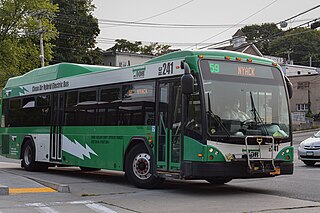
The Transport of Rockland (TOR) is the bus system for Rockland County, New York, providing service along major routes in Rockland County, as well as connections to Clarkstown Mini-Trans in Clarkstown, Spring Valley Jitney in Spring Valley, the Bee-Line Bus System in Westchester as well as connections to Rockland Coaches and Short Line Bus routes providing commuter and local service to Northern New Jersey and New York City's Port Authority Bus Terminal, George Washington Bridge Bus Station, 5th Avenue, and Long Island. Annual ridership in 2008 was 3,862,232.

Nyack High School is a secondary school in Nyack, New York, which serves parts of Orangetown and Clarkstown, New York. The original Nyack High School building is now part of BOCES. Since 1990, Nyack High School has been located less than a mile north of the old facility, at the corner of Christian Herald Road and Highland Avenue-(U.S. Route 9W).
The Clarkstown Central School District is a K-12 public school district headquartered at the Chestnut Grove Administration Building in New City, in the town of Clarkstown, New York. The district operates fifteen schools serving students in much of the Town of Clarkstown, including the hamlets and villages of New City, Bardonia, Congers, and West Nyack, as well as portions of Nanuet and Valley Cottage. It is the largest school district in Rockland County by population, with a total of 9,196 students.
