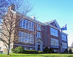
Former North Main Street School, now a satellite campus of Rockland Community College
Before the opening of the railroad, there were no homes in Spring Valley.
In 1842, the New York & Erie Railroad called this part of the territory "Pascack", after a stream by the same name. The residents of the area decided to call the place Spring Valley– one certain large spring in the Valley Pond being responsible for the name. Before naming the territory Spring Valley, it was called Scotland, named after their homeland, by Scotsmen who had settled in the area.
In 1885, E. P. Lespenasse, of Spring Valley, walked from Haverstraw, New York to Washington, D.C. to settle an election bet. He carried a live pig and a rooster on his month-long journey. Lespenasse sold over 600 copies of picture post cards of himself and the animals he carried before the start of his walk and along the way as souvenirs and to support his journey. [4]
In 1914, President Theodore Roosevelt, visited Spring Valley to discuss the political issues of the day, speaking at Lyceum.
On July 21, 1919, the Valley Theatre was first opened.
In 1923, the Edwin Gould Foundation was incorporated. The Lakeside School for Girls and the Kingsland Industrial Schools for Boys opened on South Main street.
Around World War II, Spring Valley had summer resorts that had many New York CityJewish people as customers. After World War II large resorts in the Catskill Mountains and other areas began to attract Jews instead, leaving the Spring Valley hotels empty. William Casey, Rockland County historian, said that many Hasidic groups began to settle during this period.[5]
The final steam locomotives on the Erie Railroad were commuter engines that ran between Jersey City and Spring Valley. Steam last operated on the Erie on March 17, 1954, when the fires were dropped on K-1 class Pacific locomotive No. 2530.[6]
In 2007, Spring Valley Mayor George Darden was elected vice president of the World Conference of Mayors during the organization's 23rd annual mayors' conference held in Port-au-Prince, Haiti. The organization includes mayors from the National Conference of Black Mayors and the Union of African Villages, whose goal is to foster constructive relationships among mayors around the world.
Revitalization measures are currently underway in the downtown area of the village, including a mass demolition of abandoned buildings on Main Street and the construction of new mixed-use commercial/residential buildings in its place.[7]
For over 50 years, Spring Valley was the site of a military parts distributor, Sarafan Auto Supply, which supplied military parts all around the world. This third-generation business became part of the community; as business expanded, it grew to take up a large portion of the industrial section of the downtown area. Recently the business moved out of Spring Valley, but the lot which it occupied still has many of the original buildings built by Jacob Sarafan in the early 1900s.
Corruption in Spring Valley
On August 4, 2014, Mayor Demeza Delhomme was locked up in the county jail after a state Supreme Court justice found him in contempt of a court order to open the village's civic center to host its summer camp.
In 2015 the former mayor of Spring Valley, Noramie Jasmin, was convicted in federal court in the Southern District of New York of taking kickbacks to push through a community center and catering hall. She was also convicted of extortion and wire fraud and for selling her vote for $5,000 and a 50-percent ownership stake in the building. She served out a four-year prison term at Federal Prison Camp Alderson in West Virginia.[8][9]
In June 2015 former Spring Valley deputy mayor Joseph Desmaret was sentenced to three years in federal prison for his part in a corruption scheme involving a proposal to build a village-owned catering hall on Route 45 in Spring Valley.[10]
In November 2017 Spring Valley trustee Vilair Fonvil was found guilty of corruption charges that accused him of stealing $11,000 from a summer camp program, which ended his career as a village official.[11]
According to the United States Census Bureau, the village has a total area of 2.0 square miles (5.2km2), of which 0.004 square miles (0.01km2), or 0.10%, is water.[13]
The village is approximately 5 miles (8km) north of the New Jersey border.
As of the 2010 United States census, there were 31,347 people living in the village. The racial makeup of the village was 39.4% White, 36.8% Black, 0.6% American Indian, 3.8% Asian, 0.1% Pacific Islander, 15.6% from some other race and 3.7% from two or more races. 30.6% were Hispanic or Latino of any race.[15]
As of the census[16] of 2000, there were 25,464 people, 7,566 households, and 5,523 families living in the village. The population density was 12,122.7 inhabitants per square mile (4,680.6/km2). There were 7,812 housing units at an average density of 3,719.1 per square mile (1,436.0/km2). The racial makeup of the village was 32.23% White, 59.98% African American, 0.40% Native American, 5.56% Asian, 0.25% Pacific Islander, 5.33% from other races, and 6.26% from two or more races. Hispanic or Latino of any race were 15.40% of the population.
There were 7,566 households, out of which 42.2% had children under the age of 18 living with them, 44.4% were married couples living together, 21.4% had a female householder with no husband present, and 27.0% were non-families. 20.6% of all households were made up of individuals, and 5.9% had someone living alone who was 65 years of age or older. The average household size was 3.33 and the average family size was 3.79.
In the village, the population was spread out, with 32.1% under the age of 18, 10.7% from 18 to 24, 31.7% from 25 to 44, 18.8% from 45 to 64, and 6.7% who were 65 years of age or older. The median age was 29 years. For every 100 females, there were 98.7 males. For every 100 females age 18 and over, there were 95.0 males.
The median income for a household in the village was $41,311, and the median income for a family was $42,097. Males had a median income of $31,182 versus $26,350 for females. The per capita income for the village was $14,861. 18.7% of the population and 15.2% of families were below the poverty line, 24.2% of those under the age of 18 and 16.5% of those 65 and older were living below the poverty line.
Spring Valley has the highest African American and Caribbean population in Rockland County. Spring Valley has a large Haitian and Jamaican population, along with a large and growing Hispanic population.
Tourism
Historical markers
United States Post Office – 7 North Madison Avenue
Landmarks and places of interest
U.S. Post Office, Spring Valley, NY, USASaint Paul's Episcopal Church
Finkelstein Memorial Library – 24 Chestnut Street – Built in 1940. Books, maps and news-clipping files on Rockland County history and local newsworthy events.
Holocaust Museum & Study Center – 17 South Madison Avenue – Permanent exhibit combines graphics, montages, artifacts, and audiovisual displays to detail every phase of the Holocaust. Changing art exhibits.
Spring Valley Memorial Park[18] - Memorial Park Dr - Large park in the middle of Spring Valley that contains a pool, tennis court, football/soccer field, and basketball courts.
Education
This section needs expansion. You can help by adding to it. (May 2020)
Penford, Saxby Vouler. The first hundred years of Spring Valley; Written in commemoration of the Spring Valley Centennial, 1842–1942 (Social Science Research Foundation Publications)
This page is based on this Wikipedia article Text is available under the CC BY-SA 4.0 license; additional terms may apply. Images, videos and audio are available under their respective licenses.