
Stony Point is a town in Rockland County, New York, United States. It is part of the New York City Metropolitan Area. The town is located north of the town of Haverstraw, east and south of Orange County, and west of the Hudson River and Westchester County. The population was 14,813 at the 2020 census. The name of the town is derived from a prominent projection into the Hudson River.
The Palisades Interstate Parkway (PIP) is a 38.25-mile (61.56 km) controlled-access parkway in the U.S. states of New Jersey and New York. The parkway is a major commuter route into New York City from Rockland and Orange counties in New York and Bergen County in New Jersey. The southern terminus of the route is at the George Washington Bridge in Fort Lee, New Jersey, where it connects to Interstate 95 (I-95), US 1-9, and US 46. Its northern terminus is at a traffic circle in Fort Montgomery, New York, where the PIP meets US 9W and US 202 at the Bear Mountain Bridge. At exit 18, the PIP forms a concurrency with US 6 for the remaining duration of its run.

Bear Mountain State Park is a 5,205-acre (21.06 km2) state park located on the west bank of the Hudson River in Rockland and Orange counties, New York. The park offers biking, hiking, boating, picnicking, swimming, cross-country skiing, cross-country running, sledding and ice skating. It also includes several facilities such as the Perkins Memorial Tower, the Trailside Museum and Zoo, the Bear Mountain Inn, a merry-go-round, a pool, and a skating rink. It also hosts the Bear Mountain Circle, where the historic Palisades Interstate Parkway and Bear Mountain Bridge meet. It is managed by the Palisades Interstate Park Commission, which is overseen by the State of New York.
At 47,527 acres (192.33 km2), Harriman State Park is the second largest state park in the U.S. state of New York. Located in Rockland and Orange counties 30 miles (48 km) north of New York City, it is a haven for hikers with over 200 miles (320 km) of hiking trails. The park is also known for its 31 lakes, multiple streams, public camping area, and great vistas. The park's hiking trails are currently maintained by volunteers from the New York - New Jersey Trail Conference.
U.S. Route 9W (US 9W) is a north–south United States Numbered Highway in the states of New Jersey and New York. It begins in Fort Lee, New Jersey, as Fletcher Avenue crosses the US 1/9, US 46, and Interstate 95 (I-95) approaches to the George Washington Bridge, and heads north up the west side of the Hudson River to US 9 in Albany, New York. As its "W" suffix indicates, US 9W is a westerly alternate route of US 9 between the two locations. US 9W directly serves three cities—Newburgh, Kingston, and Albany—and enters the vicinity of several others. As the route heads north, it connects to several highways of regional importance, including I-84, US 209, New York State Route 23 (NY 23), and US 20. Much of US 9W parallels the New York State Thruway and NY 32; additionally, the latter overlaps with US 9W in four different locations.

The New York – New Jersey Trail Conference (NYNJTC) is a volunteer-based federation of approximately 10,000 individual members and about 100 member organizations. The conference coordinates the maintenance of 2,000 miles of foot trails around the New York metropolitan area, from the Delaware Water Gap, north to beyond the Catskill Mountains, including the Appalachian Trail through New York and New Jersey. It also works to protect open space and publishes books and trail maps. The organization's headquarters are at 600 Ramapo Valley Road, Mahwah, New Jersey.

The Palisades Interstate Park Commission (PIPC) was formed in 1900 by Governors Theodore Roosevelt of New York and Foster Voorhees of New Jersey in response to the quarrying operations along the Palisades Cliffs of New Jersey. The Palisades, a National Natural Landmark that are also called the New Jersey Palisades or the Hudson River Palisades, are a line of steep cliffs along the west side of the lower Hudson River in Northeastern New Jersey and Southeastern New York in the United States. After its formation, the PIPC quickly moved to acquire the lands at the base of the Palisades to stop quarrying operations in both New York and New Jersey. The commission consists of ten commissioners, five appointed by each governor, and was ratified by an Act of Congress in 1937 when its interstate compact was approved. Today, the Commission owns and operates more than 125,000 acres of public parkland in New York and New Jersey including 21 state parks, 8 historic sites, and the Palisades Interstate Parkway. These parks are visited by more than 7 million people annually.

The Hudson Highlands are mountains on both sides of the Hudson River in New York state lying primarily in Putnam County on its east bank and Orange County on its west. They continue somewhat to the south in Westchester County and Rockland County, respectively. The highlands are a subrange of the Appalachian Mountains.
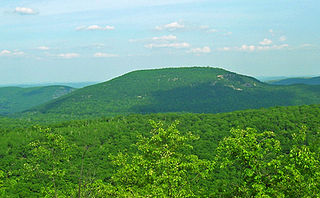
Bear Mountain is one of the best-known peaks of New York's Hudson Highlands. Located partially in Orange County in the town of Highlands and partially in Rockland County in the town of Stony Point, it lends its name to the nearby Bear Mountain Bridge and Bear Mountain State Park that contains it.

Iona Island is a 556-acre (2.25 km2) island of the Hudson River in the town of Stony Point, New York, on its west bank. The island is located approximately one mile (1.6 km) south of the Bear Mountain Bridge and is separated from the Hudson's western shore by mudflats and freshwater tidal marshes. It is part of Bear Mountain State Park, although it is occasionally listed separately as Iona Island State Park. From 1899 to 1947 the island was used as the Naval Ammunition Depot Iona Island.
Tomkins Cove is a hamlet in the Town of Stony Point, Rockland County, New York, United States, located north of Stony Point; east of Harriman State Park; south of Doodletown and west of the Hudson River. It is located north-northwest of New York City. The population is approximately 1,739 and the ZIP Code is 10986. The community is served by the 786 exchange in area code 845.

County Route 106 (CR 106) is a 7.8-mile (12.6 km) east–west county route in Rockland County, New York, in the United States. It serves as an eastward continuation of Kanawauke Road, extending from the Orange County line to U.S. Route 9W (US 9W) and US 202 in Stony Point via Harriman State Park. CR 106 intersects with several county highways in Rockland County along the way. The route was only one of two in Rockland County to keep its numbering from Orange County, with the other being CR 72. CR 106 had one spur route, CR 106A, which was recently decommissioned.
Seven Lakes Drive is a north–south parkway located in the Hudson Valley region of New York in the United States. It extends for just under 18 miles (29 km) on a northeast–southwest alignment from an intersection with New York State Route 17 (NY 17) in the village of Sloatsburg to a junction with U.S. Route 9W (US 9W) and US 202 south of the Bear Mountain Bridge in the town of Stony Point. Most of the parkway is located in either Harriman or Bear Mountain state parks, except for a small stretch near its western end. Ownership of Seven Lakes Drive is split between three entities, two of which are also responsible for maintenance of the road.

U.S. Route 202 (US 202) is a part of the U.S. Highway System that runs from New Castle, Delaware, to Bangor, Maine. In the U.S. state of New York, US 202 extends 55.57 miles (89.43 km) from the New Jersey state line near Suffern to the Connecticut state line east of Brewster. While most of US 202 is signed north–south, the portion within New York is signed east–west. It drifts north slowly as it crosses southern New York. US 202 is the only road to cross New York between New Jersey and Connecticut and not pass through New York City on the way.
Arden Valley Road is an east-west parkway located in Southfields, New York, in the United States, that travels through Harriman State Park and is owned by the Palisades Interstate Park Commission. At 5.2 miles (8.4 km) long, it begins at New York State Route 17 (NY 17) in Southfields and ends at Seven Lakes Drive in Harriman State Park. Arden Valley Road also serves a trout stocking area for the Ramapo River. The road is located entirely in Orange County and is home to the Elk's Pen Trailhead in Harriman State Park. In 1921, plans arose by the commission to construct the road, which was completed the same year and stretched along the borderline with the Harriman estate. Major William A. Welch ordered 75 elk from Yellowstone National Park to be placed in a wired cage between Arden and Southfields in 1919. The elk eventually disappeared from the pen by 1942, and the area became the current Elk's Pen trailhead for trails within Harriman State Park.
Jones Point is a former hamlet located in the town of Stony Point in Rockland County in the state of New York, United States, located north of Tomkins Cove; east of Bear Mountain State Park; south of Iona Island; and west of the Hudson River. It is directly across the Hudson River from the city of Peekskill and lies at the foot of Dunderberg Mountain.
Sandyfield was a settlement of about 30 houses in the Town of Ramapo in Rockland County, New York, United States, that was submerged in 1928 when swampy Beaver Pond was dammed to create Lake Welch in Harriman State Park.
Dunderberg Mountain is a 1,086-foot (331 m) mountain on the west bank of the Hudson River at the southern end of the Hudson Highlands. It lies just above Jones Point, New York, within Bear Mountain State Park and the town of Stony Point in Rockland County, New York.

Johnsontown is a former hamlet in the town of Stony Point in Rockland County, New York, United States.
The recorded history of Rockland County, New York begins on February 23, 1798, when the county was split off from Orange County, New York and formed as its own administrative division of the state of New York. It is located 6 miles (9.7 km) north-northwest of New York City, and is part of the New York Metropolitan Area. The county seat is the hamlet of New City. The name comes from rocky land, an early description of the area given by settlers. Rockland is New York's southernmost county west of the Hudson River. It is suburban in nature, with a considerable amount of scenic designated parkland. Rockland County does not border any of the New York City boroughs, but is only 9.5 miles (15.3 km) north of Manhattan at the counties' two respective closest points


