West Haverstraw, New York

Last updated

West Haverstraw, New York
Haverstraw NY Skyline.JPG
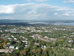
Views of West Haverstraw From Hi Tor Mountain
Rockland County New York incorporated and unincorporated areas West Haverstraw highlighted.svg
Location in Rockland County and the state of New York.
USA New York location map.svg
Red pog.svg
West Haverstraw, New York
Location within the state of New York
Coordinates: 41°12′17″N73°59′26″W / 41.20472°N 73.99056°W / 41.20472; -73.99056
Country United States
State New York
County Rockland
Incorporated 1883
Government
  MayorRobert R. D’Amelio
  Deputy MayorFrances R. Nardi
  TrusteesRalph W. Kirschkel, Robert J. LaGrow, Ramon Lopez, and Kenia Serrano
Area
[1]
  Total1.54 sq mi (3.99 km2)
  Land1.52 sq mi (3.93 km2)
  Water0.02 sq mi (0.06 km2)
Elevation
108 ft (33 m)
Population
 (2020)
  Total10,678
  Density7,034.26/sq mi (2,715.44/km2)
Time zone UTC-5 (Eastern (EST))
  Summer (DST) UTC-4 (EDT)
ZIP code
10993
Area code 845
FIPS code 36-80203 [2]
GNIS feature ID0969245 [3]
Website www.westhaverstraw.org

West Haverstraw is a village incorporated in 1883 in the town of Haverstraw, Rockland County, New York, United States. It is located northwest of Haverstraw village, east of Thiells, south of the hamlet of Stony Point, and west of the Hudson River. The population was 10,165 at the 2010 census. [4] The majority of the hamlet of Garnerville is contained in the village of West Haverstraw.

Contents

Geography

West Haverstraw is located at 41°12′17″N73°59′26″W / 41.20472°N 73.99056°W / 41.20472; -73.99056 (41.204594, -73.990665). [5]

According to the United States Census Bureau, the village has a total area of 1.5 square miles (3.9 km2), of which 1.5 square miles (3.9 km2) is land and 0.65% is water.

Demographics

Historical population
CensusPop.Note
1890 180
1900 2,0791,055.0%
1910 2,36913.9%
1920 2,018−14.8%
1930 2,83440.4%
1940 2,533−10.6%
1950 3,09922.3%
1960 5,02062.0%
1970 8,55870.5%
1980 9,1817.3%
1990 9,1830.0%
2000 10,29512.1%
2010 10,165−1.3%
2020 10,6785.0%
U.S. Decennial Census [6]

As of the census [2] of 2000, there were 10,295 people, 3,542 households, and 2,521 families residing in the village. The population density was 6,670.3 inhabitants per square mile (2,575.4/km2). There were 3,634 housing units at an average density of 2,354.5 per square mile (909.1/km2). The racial makeup of the village was 64.85% white, 12.80% African American, 0.55% Native American, 4.15% Asian, 0.10% Pacific Islander, 12.67% from other races, and 4.89% from two or more races. Hispanic or Latino of any race were 30.37% of the population.

There were 3,542 households, out of which 37.2% had children under the age of 18 living with them, 52.1% were married couples living together, 14.6% had a female householder with no husband present, and 28.8% were non-families. 24.2% of all households were made up of individuals, and 11.2% had someone living alone who was 65 years of age or older. The average household size was 2.87 and the average family size was 3.45.

In the village, the population was spread out, with 27.4% under the age of 18, 7.8% from 18 to 24, 32.2% from 25 to 44, 20.7% from 45 to 64, and 11.9% who were 65 years of age or older. The median age was 35 years. For every 100 females, there were 92.2 males. For every 100 females age 18 and over, there were 86.3 males.

The median income for a household in the village was $48,420, and the median income for a family was $55,964. Males had a median income of $37,532 versus $29,333 for females. The per capita income for the village was $19,879. About 7.9% of families and 10.6% of the population were below the poverty line, including 13.4% of those under age 18 and 12.6% of those age 65 or over.

As of the 2010 census, the population of West Haverstraw was 10,165 and the demographics were as follows:

Transportation

Local transit is operated by Transport of Rockland. The village is served by the #91, #94, #95, and #97 routes. [7] [8]

Short Line, part of Coach USA, provides daily service along U.S. Route 9W heading to and from the Port Authority Bus Terminal in Midtown Manhattan and West Point Military Academy or Newburgh.

Tourism

Historical markers

Landmarks and places of interest

Notable person

Related Research Articles

<span class="mw-page-title-main">Rockland County, New York</span> County in New York, United States

Rockland County is the second-southernmost county on the west side of the Hudson River in the U.S. state of New York, after Richmond County. It is part of the New York metropolitan area. As of the 2020 U.S. census, the county's population is 338,329, making it the state's third-most densely populated county outside New York City after Nassau and neighboring Westchester Counties. The county seat and largest city is New City. Rockland County is accessible via the New York State Thruway, which crosses the Hudson to Westchester at the Tappan Zee Bridge ten exits up from the NYC border, as well as the Palisades Parkway five exits up from the George Washington Bridge. The county's name derives from "rocky land", as the area has been aptly described, largely due to the Hudson River Palisades.

<span class="mw-page-title-main">Emmett, Michigan</span> Village in Michigan, United States

Emmett is a village in St. Clair County of the U.S. state of Michigan. The population was 269 at the 2010 census. The village is located within Emmett Township.

<span class="mw-page-title-main">Highlands, New York</span> Town in New York, United States

Highlands is a town on the eastern border of Orange County, New York. The population was 12,939 at the 2020 census. West Point, including the United States Military Academy, is located alongside the Hudson River in Highlands, and the military reservation occupies a large part of the town.

<span class="mw-page-title-main">Bardonia, New York</span> Hamlet & CDP in New York, United States

Bardonia is a hamlet and census-designated place in the town of Clarkstown, Rockland County, New York, United States. It is located northeast of Nanuet, northwest of West Nyack, south of New City, and west of Valley Cottage. The population was 4,108 at the 2010 census.

<span class="mw-page-title-main">Clarkstown, New York</span> Town in New York, United States

Clarkstown is a town in Rockland County, New York, United States. The town is on the eastern border of the county, located north of the town of Orangetown, east of the town of Ramapo, south of the town of Haverstraw, and west of the Hudson River. As of the 2020 census, the town had a total population of 86,855. The hamlet of New City, the county seat of Rockland County, is also the seat of town government and of the Clarkstown Police Department, the county sheriff's office, and the county correctional facility. New City makes up about 41.47% of the town's population.

<span class="mw-page-title-main">Congers, New York</span> Census-designated place in New York, United States

Congers is a suburban hamlet and census-designated place in the town of Clarkstown, Rockland County, New York, United States. It is located north of Valley Cottage, east of New City, across Lake DeForest, south of Haverstraw, and west of the Hudson River. It lies 19 miles (31 km) north of New York City's Bronx boundary. As of the 2020 census, the population was 8,532.

<span class="mw-page-title-main">Mount Ivy, New York</span> Census-designated place in New York, United States

Mount Ivy is a hamlet and census-designated place in the Town of Haverstraw, in Rockland County, New York, United States. It is located north of New City, east of Pomona, south of Thiells, and west of Garnerville. The population was 6,878 at the 2010 census.

<span class="mw-page-title-main">New City, New York</span> Census-designated place in New York, United States

New City is a hamlet and census-designated place in the town of Clarkstown, Rockland County, New York, United States, part of the New York Metropolitan Area. An affluent suburb of New York City, the hamlet is located 18 miles (29 km) north of the city at its closest point, Riverdale, Bronx. Within Rockland County, New City is located north of Bardonia, northeast of Nanuet, east of New Square and New Hempstead, south of Garnerville and the village of Haverstraw, and west of Congers. New City's population was 35,101 at the 2020 census, making it the 14th most populous CDP/hamlet in the state of New York.

<span class="mw-page-title-main">New Hempstead, New York</span> Village in New York, United States

New Hempstead is a village in the town of Ramapo, Rockland County, New York, United States. It is located north of New Square, east of Wesley Hills, south of Pomona, and west of New City. The population was 5,132 at the 2010 census. Residents utilize the Spring Valley and New City post offices.

<span class="mw-page-title-main">Orangeburg, New York</span> Census-designated place in New York, United States

Orangeburg is a hamlet and census-designated place, in the town of Orangetown, Rockland County, New York, United States. It is located north of Tappan, south of Blauvelt, east of Pearl River and west of Piermont. The population was 4,568 at the 2010 census.

<span class="mw-page-title-main">Pomona, New York</span> Village in New York, United States

Pomona is a village partly in the town of Ramapo and partly in the town of Haverstraw in Rockland County, New York, United States. It is located north of New Hempstead, east of Harriman State Park, north of Monsey and west of Mount Ivy. According to the 2020 Census, the population was 3,824, a 23 percent increase from the 2010 figure of 3,103.

<span class="mw-page-title-main">Thiells, New York</span> Census-designated place in New York, United States

Thiells, known as Thiell's Corner in the 1850s, is a hamlet and census-designated place (CDP) in the town of Haverstraw, Rockland County, New York, United States. It is located north of Mount Ivy, east of Pomona, south of Tomkins Cove, and west of Garnerville. The population was 5,240 as of the 2020 census.

<span class="mw-page-title-main">Valley Cottage, New York</span> Census-designated place in New York, United States

Valley Cottage is a hamlet and census-designated place in the town of Clarkstown, New York, United States. It is located northeast of West Nyack, northwest of Central Nyack east of Bardonia, south of Congers, northwest of Nyack, and west of Upper Nyack. The population was 9,107 at the 2010 census.

<span class="mw-page-title-main">Catskill (village), New York</span> Village in New York, United States

Catskill is a village and county seat of Greene County, New York, United States. The population was 3,745 at the 2020 census, down from 4,081 at the 2010 census, down from 4,392 in 2000. The village is in the northeastern part of the town of Catskill.

<span class="mw-page-title-main">Haverstraw (village), New York</span> Village in New York, United States

Haverstraw is a village incorporated in 1854 in the town of Haverstraw in Rockland County, New York, United States. It is located north of Congers, southeast of West Haverstraw, east of Garnerville, northeast of New City, and west of the Hudson River at its widest point. As of the 2020 census, the population was 12,323.

<span class="mw-page-title-main">Haverstraw, New York</span> Town in New York, United States

Haverstraw is a town in Rockland County, New York, United States, located north of the Town of Clarkstown and the Town of Ramapo; east of Orange County; south of the Town of Stony Point; and west of the Hudson River. The town runs from the west to the east border of the county in its northern section. The population was 39,087 at the 2020 census.

<span class="mw-page-title-main">Stony Point (CDP), New York</span> Census-designated place in New York, United States

Stony Point is a hamlet and census-designated place in the town of Stony Point, Rockland County, New York, United States. It is located north of West Haverstraw, east of Harriman State Park, south of Tomkins Cove, and west of the Hudson River. The population was 12,147 at the 2010 census.

<span class="mw-page-title-main">Stony Point, New York</span> Town in New York, United States

Stony Point is a town in Rockland County, New York, United States. It is part of the New York City Metropolitan Area. The town is located north of the town of Haverstraw, east and south of Orange County, and west of the Hudson River and Westchester County. The population was 14,813 at the 2020 census. The name of the town is derived from a prominent projection into the Hudson River.

<span class="mw-page-title-main">Sparkill, New York</span> Census-designated place in New York, United States

Sparkill, formerly known as Tappan Sloat, is a suburban hamlet and census-designated place in the Town of Orangetown, Rockland County, New York, United States located north of Palisades; east of Tappan; south of Piermont and west of the Hudson River. As of the 2010 census, the CDP had a population of 1,565. The hamlet is home to St. Thomas Aquinas College and the Dominican Sisters of Sparkill.

<span class="mw-page-title-main">Saugerties (village), New York</span> Village in Ulster County, New York, United States

Saugerties is a village in Ulster County, New York, United States. The population was 3,899 at the 2020 census, showing a slight decline from the 3,971 counted at the 2010 census.

References

  1. "ArcGIS REST Services Directory". United States Census Bureau. Retrieved September 20, 2022.
  2. 1 2 "U.S. Census website". United States Census Bureau . Retrieved January 31, 2008.
  3. "US Board on Geographic Names". United States Geological Survey. October 25, 2007. Retrieved January 31, 2008.
  4. "Profile of General Population and Housing Characteristics: 2010 Demographic Profile Data (DP-1): West Haverstraw village, New York". United States Census Bureau . Retrieved February 7, 2012.
  5. "US Gazetteer files: 2010, 2000, and 1990". United States Census Bureau. February 12, 2011. Retrieved April 23, 2011.
  6. "Census of Population and Housing". Census.gov. Retrieved June 4, 2015.
  7. "TOR_RouteMap" (PDF). rocklandgov.com. Retrieved February 3, 2024.
  8. "County of Rockland, New York :: Transport of Rockland (TOR)". rocklandgov.com. Retrieved June 7, 2018.