
Route 208 is a state highway in the northern part of New Jersey in the United States. It runs 10.07 miles (16.21 km) from an interchange with Route 4 and County Route 79 in Fair Lawn northwest to an interchange with Interstate 287 (I-287) in Oakland. The route runs through suburban areas of Bergen and Passaic counties as a four- to six-lane divided highway. It is a limited-access road, as intersections with cross roads are controlled by interchanges, but is not a controlled access road as several driveways exist. The route runs through the communities of Fair Lawn, Glen Rock, Hawthorne, Wyckoff, and Franklin Lakes along the way, interchanging with CR 507 in Fair Lawn and CR 502 in Franklin Lakes.

The Passaic River is a river, approximately 80 mi (129 km) long, in northern New Jersey, United States. The river in its upper course flows in a highly circuitous route, meandering through the swamp lowlands between the ridge hills of rural and suburban northern New Jersey, called the Great Swamp, draining much of the northern portion of the state through its tributaries. In its lower portion, it flows through the most urbanized and industrialized areas of the state, including along downtown Newark. The lower river suffered from severe pollution and industrial abandonment in the 20th century. In April 2014, the U.S. Environmental Protection Agency (EPA) announced a $1.7 billion plan to remove 4.3 million cubic yards of toxic mud from the bottom of lower eight miles (13 km) of the river. It is considered one of the most polluted stretches of water in the nation and the project one of the largest clean-ups ever undertaken.

The Second River, or Watsessing River, in the state of New Jersey in the United States, is the second main tributary of the Passaic River encountered while travelling upstream from its mouth at Newark Bay.

The Saddle River flows south through much of Bergen County, New Jersey. The river runs through densely populated suburban areas for much of its course. The river takes its name from the river near Saddell in Argyll and Bute in Scotland.

Ho-Ho-Kus Brook is a tributary of the Saddle River in Bergen County, New Jersey, in the United States.
Franklin Township was a township that existed in Bergen County, New Jersey, United States from 1771 until 1926.
Stevenson Brook is a tributary of the Passaic River in Hawthorne, Passaic County, New Jersey in the United States.

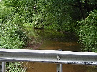
Goffle Brook is a tributary of the Passaic River which flows south through a section of Passaic County and Bergen County in New Jersey and drains the eastern side of the First Watchung Mountain. Heading up the brook from the confluence with the Passaic River, one encounters the borough of Hawthorne, the village of Ridgewood, the borough of Midland Park, and the township of Wyckoff.

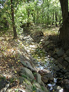
Diamond Brook, also known as Bass Brook, is a tributary of the Passaic River which flows south through a section of Bergen County in New Jersey, United States. Heading up the brook from the Passaic River, one encounters the boroughs of Fair Lawn and Glen Rock, as well as the village of Ridgewood.
Salt Brook is a tributary of the Passaic River in Union County, New Jersey in the United States.
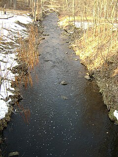
Molly Ann Brook is a tributary of the Passaic River which flows south between the northern ranges of First Watchung Mountain and Second Watchung Mountain in Passaic County and Bergen County, New Jersey. Traveling north from its confluence with the Passaic River, Molly Ann Brook passes through the city of Paterson and the boroughs of Haledon, Prospect Park, North Haledon and Franklin Lakes.

Goffle Brook Park is a public, county park spanning much of the length of Goffle Brook through the borough of Hawthorne in Passaic County, New Jersey, United States. Since its designation and construction between 1930 and 1932, the park has served to protect the waters of Goffle Brook while at the same time providing recreational opportunities to the residents of Passaic County and nearby Bergen County. Goffle Brook Park has been included in the National Register of Historic Places since 2002.

Six Mile Run is a tributary of the Millstone River that drains a large area in central Franklin Township in Somerset County and as well western portions of North Brunswick and South Brunswick Townships in Middlesex County, New Jersey in the United States.

Goffle Hill, also referred to as Goffle Mountain and historically known as Totoway Mountain and Wagaraw Mountain, is a range of the trap rock Watchung Mountains on the western edge of the Newark Basin in northern New Jersey. The hill straddles part of the border of Bergen County and Passaic County, underlying a mostly suburban setting. While hosting patches of woodlands, perched wetlands, and traprock glades, the hill is largely unprotected from development. Extensive quarrying for trap rock has obliterated large tracts of the hill in North Haledon, and Prospect Park. Conservation efforts seeking to preserve undeveloped land, such as the local Save the Woods initiative (2007–present), are ongoing.
Nine Mile Run, known as Ninemile Run according to the USGS GNIS, is a moderately large tributary of the Six Mile Run, one of the branches of the Millstone River, in central New Jersey in the United States.

Sucker Brook is a tributary of Lawrence Brook in central New Jersey in the United States.

Simonson Brook, also known as Sunonson Brook, is a tributary of the Millstone River in southern Franklin Park, Somerset County, New Jersey in the United States.
McDonald's Brook is tributary of the Passaic River. It is a natural stream originating in Clifton, New Jersey, passing through Passaic, New Jersey. For most of its length, it runs underground in a culvert constructed by the United States Army Corps of Engineers. Prior to the construction of the culvert, larger parts of it ran through a ground-level stream bed, though parts of it ran underground even in its natural configuration.

