Related Research Articles

In meteorology, a cyclone is a large air mass that rotates around a strong center of low atmospheric pressure, counterclockwise in the Northern Hemisphere and clockwise in the Southern Hemisphere as viewed from above. Cyclones are characterized by inward-spiraling winds that rotate about a zone of low pressure. The largest low-pressure systems are polar vortices and extratropical cyclones of the largest scale. Warm-core cyclones such as tropical cyclones and subtropical cyclones also lie within the synoptic scale. Mesocyclones, tornadoes, and dust devils lie within the smaller mesoscale.

A subtropical cyclone is a weather system that has some characteristics of both tropical and extratropical cyclones.

The 1976 Atlantic hurricane season was a fairly average Atlantic hurricane season in which 21 tropical or subtropical cyclones formed. 10 of them became nameable storms. Six of those reached hurricane strength, with two of the six becoming major hurricanes, which are Category 3 or higher on the Saffir–Simpson scale. The season officially began on June 1 and lasted until November 30. These dates conventionally delimit the period of each year when most tropical cyclones form in the Atlantic basin. However, the first system, a subtropical storm, developed in the Gulf of Mexico on May 21, several days before the official start of the season. The system spawned nine tornadoes in Florida, resulting in about $628,000 (1976 USD) in damage, though impact was minor otherwise.
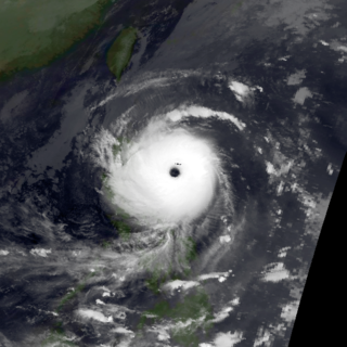
Typhoon Tip, known in the Philippines as Super Typhoon Warling, was a large, extremely powerful, and long-lived tropical cyclone that traversed the Western Pacific for 20 days. The forty-third tropical depression, nineteenth tropical storm, twelfth typhoon, and third super typhoon of the 1979 Pacific typhoon season, Tip developed out of a disturbance within the monsoon trough on October 4 near Pohnpei in Micronesia. Initially, Tropical Storm Roger to the northwest hindered the development and motion of Tip, though after the storm tracked farther north, Tip was able to intensify. After passing Guam, Tip rapidly intensified and reached peak sustained winds of 305 km/h (190 mph) and a worldwide record-low sea-level pressure of 870 hPa (25.69 inHg) on October 12. At its peak intensity, Tip was the largest tropical cyclone on record, with a wind diameter of 2,220 km (1,380 mi). Tip slowly weakened as it continued west-northwestward and later turned to the northeast, in response to an approaching trough. The typhoon made landfall in southern Japan on October 19, and became an extratropical cyclone shortly thereafter. Tip's extratropical remnants continued moving east-northeastward, until they dissipated near the Aleutian Islands on October 24.

A tropical wave, in and around the Atlantic Ocean, is a type of atmospheric trough, an elongated area of relatively low air pressure, oriented north to south, which moves from east to west across the tropics, causing areas of cloudiness and thunderstorms. Tropical waves form in the easterly flow along the equatorial side of the subtropical ridge or belt of high air pressure which lies north and south of the Intertropical Convergence Zone (ITCZ). Tropical waves are generally carried westward by the prevailing easterly winds along the tropics and subtropics near the equator. They can lead to the formation of tropical cyclones in the north Atlantic and northeastern Pacific basins. A tropical wave study is aided by Hovmöller diagrams, a graph of meteorological data.

The 1911 Atlantic hurricane season was a relatively inactive hurricane season, with only six known tropical cyclones forming in the Atlantic during the summer and fall. There were three suspected tropical depressions, including one that began the season in February and one that ended the season when it dissipated in December. Three storms intensified into hurricanes, two of which attained Category 2 status on the modern-day Saffir–Simpson Hurricane Scale. Storm data is largely based on the Atlantic hurricane database, which underwent a thorough revision for the period between 1911 and 1914 in 2005.

The 1986 Pacific hurricane season featured several tropical cyclones that contributed to significant flooding to the Central United States. The hurricane season officially started May 15, 1986, in the eastern Pacific, and June 1, 1986 in the central Pacific, and lasted until November 30, 1986 in both regions. These dates conventionally delimit the period of each year when most tropical cyclones form in the northeastern Pacific Ocean. A total of 17 named storms and 9 hurricanes developed during the season; this is slightly above the averages of 15 named storms and 8 hurricanes, respectively. In addition, 26 tropical depressions formed in the eastern Pacific during 1986, which, at the time, was the second most ever recorded; only the 1982 Pacific hurricane season saw a higher total.

The 1998 Pacific typhoon season was the least active Pacific typhoon season on record, until it was surpassed 12 years later. It would produce 16 tropical storms, 8 strengthening into typhoons. The scope of this article is limited to the Pacific Ocean, north of the equator and west of the International Date Line. Storms that form east of the date line and north of the equator are called hurricanes; see 1998 Pacific hurricane season. Tropical Storms formed in the entire west Pacific basin were assigned a name by the Joint Typhoon Warning Center. Tropical depressions in this basin have the "W" suffix added to their number. Tropical depressions that enter or form in the Philippine area of responsibility are assigned a name by the Philippine Atmospheric, Geophysical and Astronomical Services Administration or PAGASA. This can often result in the same storm having two names.

The 1985 Pacific typhoon season was a slightly above average season in terms of named storms, though most storms were weak and short-lived. The season had 28 named storms, 15 typhoons and 1 super typhoon. It ran year-round, thus ending the two-season run which began in 1983 that only had tropical cyclones forming between June and December. These dates conventionally delimit the period of each year when most tropical cyclones form in the northwestern Pacific Ocean. A total of 57 tropical depressions formed this year, of which only 28 became tropical storms and were assigned a name by the Joint Typhoon Warning Center. This made the season well above average. Additionally, tropical depressions that enter or form in the Philippine area of responsibility were assigned a name by the Philippine Atmospheric, Geophysical and Astronomical Services Administration or PAGASA. This can often result in the same storm having two names. This year, a total of 17 storms were named this way.

The 1981 Pacific typhoon season was a slightly above average season that produced 29 tropical storms, 13 typhoons and two intense typhoons. The season ran throughout 1981, though most tropical cyclones typically develop between May and October. The season's first named storm, Freda, developed on March 12 while the final storm, Lee, dissipated on December 29. Tropical cyclones only accounted for 12 percent of the rainfall in Hong Kong this season, the lowest percentage for the protectorate since 1972.

The 1979 Pacific typhoon season featured the largest and most intense tropical cyclone recorded globally, Typhoon Tip. The season also used both male and female names as tropical cyclone names for the first time. Additionally, the season was slightly below-average in terms of tropical cyclone activity, with only 24 storms, 12 typhoons, and 4 super typhoons developing. The season had no official bounds; it ran year-round in 1979, but most tropical cyclones tend to form in the northwestern Pacific Ocean between June and December. These dates conventionally delimit the period of each year when most tropical cyclones form in the northwestern Pacific Ocean.

Tropical cyclogenesis is the development and strengthening of a tropical cyclone in the atmosphere. The mechanisms through which tropical cyclogenesis occurs are distinctly different from those through which temperate cyclogenesis occurs. Tropical cyclogenesis involves the development of a warm-core cyclone, due to significant convection in a favorable atmospheric environment.

Extratropical cyclones, sometimes called mid-latitude cyclones or wave cyclones, are low-pressure areas which, along with the anticyclones of high-pressure areas, drive the weather over much of the Earth. Extratropical cyclones are capable of producing anything from cloudiness and mild showers to severe gales, thunderstorms, blizzards, and tornadoes. These types of cyclones are defined as large scale (synoptic) low pressure weather systems that occur in the middle latitudes of the Earth. In contrast with tropical cyclones, extratropical cyclones produce rapid changes in temperature and dew point along broad lines, called weather fronts, about the center of the cyclone.

Hurricane Gordon developed during a fourteen-day period along an erratic, persistent, and highly unusual path. The hurricane formed near Panama in the southwestern Caribbean on November 8, 1994. As a tropical depression, it brushed Nicaragua and spent several days in the waters off the country's coast. Strengthening slightly into a tropical storm, Gordon wound its way north into the Greater Antilles. Despite warm waters, persistent wind shear prevented significant strengthening. Executing a slow turn to the north and then the northwest, Gordon made two more landfalls, on eastern Jamaica and eastern Cuba, while delivering tremendous rains to western Hispaniola.

An upper tropospheric cyclonic vortex is a vortex, or a circulation with a definable center, that usually moves slowly from east-northeast to west-southwest and is prevalent across Northern Hemisphere's warm season. Its circulations generally do not extend below 6,080 metres (19,950 ft) in altitude, as it is an example of a cold-core low. A weak inverted wave in the easterlies is generally found beneath it, and it may also be associated with broad areas of high-level clouds. Downward development results in an increase of cumulus clouds and the appearance of circulation at ground level. In rare cases, a warm-core cyclone can develop in its associated convective activity, resulting in a tropical cyclone and a weakening and southwest movement of the nearby upper tropospheric cyclonic vortex. Symbiotic relationships can exist between tropical cyclones and the upper level lows in their wake, with the two systems occasionally leading to their mutual strengthening. When they move over land during the warm season, an increase in monsoon rains occurs.

The 1989–90 Australian region cyclone season was an above average tropical cyclone season. It was also an event in the ongoing cycle of tropical cyclone formation. It ran from 1 November 1989 to 30 April 1990. The regional tropical cyclone operational plan also defines a tropical cyclone year separately from a tropical cyclone season, and the "tropical cyclone year" ran from 1 July 1989 to 30 June 1990.
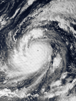
Typhoon Elsie, known in the Philippines as Typhoon Tasing, was one of the most intense known tropical cyclones to make landfall in the Philippines. A powerful Category 5 super typhoon, Elsie formed out of a tropical disturbance on October 13, 1989, and initially moved relatively slowly in an area of weak steering currents. On October 15, the storm underwent a period of rapid intensification, attaining an intensity that corresponds to a Category 3 hurricane on the Saffir–Simpson hurricane scale. After taking a due west track towards the northern Philippines, the storm intensified further, becoming a Category 5 super typhoon hours before making landfall in Luzon. After moving inland, the typhoon rapidly weakened to a tropical storm. Once back over water in the South China Sea, wind shear prevented re-intensifcation. Elsie eventually made landfall in Vietnam on October 22 and dissipated the following day over Laos.
A cold-core low, also known as an upper level low or cold-core cyclone, is a cyclone aloft which has an associated cold pool of air residing at high altitude within the Earth's troposphere, without a frontal structure. It is a low pressure system that strengthens with height in accordance with the thermal wind relationship. If a weak surface circulation forms in response to such a feature at subtropical latitudes of the eastern north Pacific or north Indian oceans, it is called a subtropical cyclone. Cloud cover and rainfall mainly occurs with these systems during the day.

A Gulf of California moisture surge, or simply gulf surge, is a meteorological event where a pulse of high humidity air is pushed up the Gulf of California. Gulf surges bring moisture to southern Arizona during the North American Monsoon. Prior to the 1970s, the consensus of meteorologists was the moisture that fueled the central and southern Arizona monsoon resulted from the movement of the Bermuda High to a more south and west position, which in turn transported water vapor to the region from the Gulf of Mexico. However, operational meteorologists in the 1970s described episodic surges of moisture that infiltrated the area that was thought to originate in the Gulf of California. It was noted that these episodes were likely to be associated with a convective system near the tip of the Baja peninsula such as a tropical cyclone or an easterly wave.

Tropical Storm Ignacio was a strong tropical storm that deluged the Mexican coast with heavy rains. The 9th named storm and 11th tropical cyclone of the 1991 Pacific hurricane season, the system formed from two tropical waves. The pair moved across the Atlantic during the first ten days of September. The second of the two spawned Tropical Storm Erika in the eastern Atlantic. Emerging into the eastern Pacific between the September 10 and September 12, an area of thunderstorms developed southeast of an upper level cyclone off the southern tip of Baja California Sur due to the interaction of the upper cyclone with the pair of tropical waves. By the September 15, the thunderstorm activity organized into bands, indicating the presence of a new tropical depression, the eleventh of the season. The cyclone moved north-northwest due to steering around the upper cyclone, and became a tropical storm by noon on the September 16. Once the upper cyclone moved away from Ignacio, its motion towards the Mexican coast stopped on September 17, and it executed a slow anticyclonic loop that would be completed late on the September 18. Proximity to land and west to southwesterly vertical wind shear weakened the cyclone, and Ignacio regained tropical depression status late on the September 18. The system dissipated as a tropical cyclone that night, and its remnants moved west-southwest into the tropical Pacific, occasionally flaring up new convection over the succeeding couple days.
References
- ↑ R. N. Ferreira; W. H. Schubert (1999). "The role of tropical cyclones in the formation of tropical upper-tropospheric troughs". Journal of the Atmospheric Sciences. 56 (16): 2891–2907. Bibcode:1999JAtS...56.2891N. doi: 10.1175/1520-0469(1999)056<2891:TROTCI>2.0.CO;2 . ISSN 0022-4928 . Retrieved 2009-12-23.
- 1 2 Roger Graham Barry & Andrew Mark Carleton (2001). Synoptic and dynamic climatology. Psychology Press. p. 519. ISBN 978-0-415-03115-8.
- ↑ Glenn White. Tropical Upper Tropospheric Trough—July 2001. Archived 2011-05-26 at the Wayback Machine Retrieved on 2008-11-25.
- ↑ James C. Sadler (October 1976). "A Role of the Tropical Upper Tropospheric Trough in Early Season Typhoon Development". Monthly Weather Review. 104 (10): 1266–1278. Bibcode:1976MWRv..104.1266S. doi: 10.1175/1520-0493(1976)104<1266:AROTTU>2.0.CO;2 .
- ↑ Clark Evans (January 5, 2006). "Favorable trough interactions on tropical cyclones". Flhurricane.com. Retrieved 2006-10-20.
- ↑ Deborah Hanley; John Molinari & Daniel Keyser (October 2001). "A Composite Study of the Interactions between Tropical Cyclones and Upper-Tropospheric Troughs". Monthly Weather Review . 129 (10): 2570–84. Bibcode:2001MWRv..129.2570H. doi: 10.1175/1520-0493(2001)129<2570:ACSOTI>2.0.CO;2 .