Hurricane Joaquin

Last updated

Spanish: [xwaˈkin] , wah-KEEN) [1] was a powerful tropical cyclone that devastated several districts of The Bahamas and caused damage in the Turks and Caicos Islands, parts of the Greater Antilles, and Bermuda. It was also the strongest Atlantic hurricane of non-tropical origin recorded in the satellite era. [2] [3] The tenth named storm, third hurricane, and second major hurricane of the 2015 Atlantic hurricane season, Joaquin evolved from a non-tropical low to become a tropical depression on September 28, well southwest of Bermuda. Tempered by unfavorable wind shear, the depression drifted southwestward. After becoming a tropical storm the next day, Joaquin underwent rapid intensification, reaching hurricane status on September 30 and Category 4 major hurricane strength on October 1. Meandering over the southern Bahamas, Joaquin's eye passed near or over several islands. On October 3, the hurricane weakened somewhat and accelerated to the northeast. Abrupt re-intensification ensued later that day, and Joaquin acquired sustained winds of 155 mph (250 km/h), just short of Category 5 strength.

Contents

Hurricane warnings were hoisted across most of The Bahamas as the hurricane threatened the country. Battering the nation's southern islands for over two days, Joaquin caused extensive devastation, most notably on Acklins, Crooked Island, Long Island, Rum Cay, and San Salvador Island. Severe storm surge inundated many communities, trapping hundreds of people in their homes; flooding persisted for days after the hurricane's departure. Prolonged, intense winds brought down trees and powerlines, and unroofed homes throughout the affected region. As airstrips were submerged and heavily damaged, relief workers were limited in their ability to quickly help residents affected by Joaquin, one of the strongest storms on record to affect the nation. Offshore, the American cargo ship El Faro and her 33 members were lost to the hurricane.

Coastal flooding also impacted the nearby Turks and Caicos, washing out roadways, compromising seawalls, and damaging homes. Strong winds and heavy rainfall caused some property damage in eastern Cuba. One fisherman died when heavy seas capsized a small boat along the coast of Haiti. Storm tides resulted in severe flooding in several departments of Haiti, forcing families from their homes and destroying crops. The weakening hurricane passed just west of Bermuda on October 4, attended by strong winds that cut power to 15,000 electric subscribers but caused only minor damage otherwise. After passing near Bermuda, Joaquin ultimately curved northeastward and accelerated, weakening further and becoming extratropical as it entered colder waters. After dissipating, its remnants traveled eastward, reaching Portugal before being absorbed by a frontal system.

Collectively, Joaquin killed 34 people and caused US$200 million in damage. [4] [5] With all 34 deaths attributed to the storm occurring at sea, Joaquin has the highest offshore death toll for any Atlantic hurricane since the Escuminac hurricane in 1959, which killed 35 people in the Northumberland Strait. [6]

Although Joaquin never directly affected the United States, another large storm system over the southeastern states drew tremendous moisture from the hurricane, resulting in catastrophic flooding in South Carolina.

Meteorological history

Map plotting the storm's track and intensity, according to the Saffir-Simpson scale

.mw-parser-output .hidden-begin{box-sizing:border-box;width:100%;padding:5px;border:none;font-size:95%}.mw-parser-output .hidden-title{font-weight:bold;line-height:1.6;text-align:left}.mw-parser-output .hidden-content{text-align:left}@media all and (max-width:500px){.mw-parser-output .hidden-begin{width:auto!important;clear:none!important;float:none!important}}
Map key
Saffir-Simpson scale
.mw-parser-output .div-col{margin-top:0.3em;column-width:30em}.mw-parser-output .div-col-small{font-size:90%}.mw-parser-output .div-col-rules{column-rule:1px solid #aaa}.mw-parser-output .div-col dl,.mw-parser-output .div-col ol,.mw-parser-output .div-col ul{margin-top:0}.mw-parser-output .div-col li,.mw-parser-output .div-col dd{page-break-inside:avoid;break-inside:avoid-column}
.mw-parser-output .legend{page-break-inside:avoid;break-inside:avoid-column}.mw-parser-output .legend-color{display:inline-block;min-width:1.25em;height:1.25em;line-height:1.25;margin:1px 0;text-align:center;border:1px solid black;background-color:transparent;color:black}.mw-parser-output .legend-text{}
Tropical depression (<=38 mph, <=62 km/h)

Tropical storm (39-73 mph, 63-118 km/h)

Category 1 (74-95 mph, 119-153 km/h)

Category 2 (96-110 mph, 154-177 km/h)

Category 3 (111-129 mph, 178-208 km/h)

Category 4 (130-156 mph, 209-251 km/h)

Category 5 (>=157 mph, >=252 km/h)

Unknown
Storm type
Tropical cyclone
Subtropical cyclone
Extratropical cyclone, remnant low, tropical disturbance, or monsoon depression Joaquin 2015 path.png
Map plotting the storm's track and intensity, according to the Saffir–Simpson scale
Map key
  Tropical depression (≤38 mph, ≤62 km/h)
  Tropical storm (39–73 mph, 63–118 km/h)
  Category 1 (74–95 mph, 119–153 km/h)
  Category 2 (96–110 mph, 154–177 km/h)
  Category 3 (111–129 mph, 178–208 km/h)
  Category 4 (130–156 mph, 209–251 km/h)
  Category 5 (≥157 mph, ≥252 km/h)
  Unknown
Storm type
ArrowUp.svg Extratropical cyclone, remnant low, tropical disturbance, or monsoon depression

On September 25, 2015, the US National Hurricane Center (NHC) began monitoring an upper-level low, accompanied by a surface trough, several hundred miles south-southwest of Bermuda for possible tropical cyclogenesis. [7] The system gradually consolidated as it drifted north-northwest, acquiring a closed surface low late on September 26. [8] Convective showers and thunderstorms steadily increased on September 27, and at 03:00  UTC on September 28 the NHC assessed the system to have become a tropical depression, situated roughly 405 mi (650 km) southwest of Bermuda. [9] [10] [11] Although the depression featured a well-defined low, strong wind shear displaced convection and exposed the circulation. A ridge to the north was forecast to steer the system slowly northwest into a region of higher shear; meteorologists at the NHC initially depicted the system dissipating within 96 hours based on modeling depictions. [10] Convection developed and persisted closer to the circulation centre throughout September 28, [12] and early on September 29, Dvorak satellite classifications indicated the system became a tropical storm. Accordingly, it was assigned the name Joaquin, becoming the tenth named storm of the season. [13] [14]

Hurricane Joaquin meandering around the Bahamas on October 2. Note the system to its north, which produced heavy rainfall over the Carolinas Joaquin 2015-10-02 1645Z.png
Hurricane Joaquin meandering around the Bahamas on October 2. Note the system to its north, which produced heavy rainfall over the Carolinas

Strengthening of the mid-level ridge prompted a sudden shift in Joaquin's trajectory to the southwest, directing it towards the Bahamas. [13] [15] Forecasters at the NHC noted considerable uncertainty in the future of Joaquin, with forecast models depicting a wide range of possibilities. [16] Throughout September 29, the storm steadily intensified as its circulation became embedded within deep convection and upper-level outflow became increasingly prominent. [17] High sea surface temperatures and decreasing shear aided strengthening, and early on September 30, the storm achieved hurricane status. [18] [19] Rapid intensification ensued thereafter, with an eye developing within a symmetric central dense overcast. Data from aircraft reconnaissance indicated that Joaquin reached Category 3 status on the Saffir–Simpson hurricane wind scale by 03:00 UTC on October 1. [20] Around 12:00 UTC the eye of Joaquin passed over Samana Cay, Bahamas, with winds of 130 mph (215 km/h), making it a Category 4 hurricane. [21] Around this same time, its eye contracted from 41 to 27 mi (66 to 43 km) in diameter, representing significant intensification. [22] [23] At this time Joaquin was located just 15 mi (25 km) northwest of Crooked Island. [24] The storm's central pressure bottomed out at 931 mbar (hPa; 27.49  inHg) around 00:00 UTC on October 2. [25]

As the ridge previously steering Joaquin southwest began retreating north, the hurricane's movement slowed and shifted west, and later north, early on October 2. [26] [27] An eyewall replacement cycle—a process whereby a second, larger eye develops while the inner eye collapses—began that morning; [28] its eye became increasingly ill-defined in satellite imagery. [27] Slight weakening took place accordingly, [29] and the hurricane passed over Rum Cay and San Salvador Island around 16:00 UTC and 21:00 UTC with winds of 125 mph (205 km/h); [21] a pressure near 944 mbar (hPa; 27.88 inHg) was observed on San Salvador Island. [30] An amplifying trough over the Southeastern United States enhanced southwesterly flow over Joaquin on October 3 and prompted the hurricane to accelerate northeast away from the Bahamas. [31] Throughout the day the storm's eye became increasingly defined and re-intensification ensued. [32] Aircraft reconnaissance found a considerably stronger system that afternoon; based on flight-level winds of 166 mph (267 km/h), it is estimated that Joaquin attained surface winds of 155 mph (250 km/h)—a high-end Category 4 hurricane—by 16:00 UTC. [33] This made Joaquin the strongest Atlantic hurricane of non-tropical origin recorded in the satellite era. [21]

GOES animation of Hurricane Joaquin from September 28 to October 7 Joaquin boucle.gif
GOES animation of Hurricane Joaquin from September 28 to October 7

Shortly after peaking, the hurricane's overall structure began to deteriorate, signalling a weakening trend. [34] On October 4 the storm curved towards the north-northeast between a large low-pressure system to its west and a mid-level ridge to its east. [35] As deep convection over its core continued to wane, [36] Joaquin passed about 70 mi (110 km) west-northwest of Bermuda near 00:00 UTC on October 5, with winds of 85 mph (140 km/h). [21] The weakening trend slowed that day as the storm's satellite presentation improved slightly, marked by brief reappearances of a distinct eye feature. Joaquin gradually turned northeastward around the periphery of the weak ridge, and subsequently accelerated toward the east-northeast as it entered the prevailing westerlies. [37] The system maintained hurricane intensity until 15:00 UTC on October 7, by which point strengthening wind shear and an increasingly colder environment began to take their toll. [38] The cloud pattern became lopsided as colder, drier air infiltrated the circulation, forming the first stages of a frontal structure. [39] With its extratropical transition well underway, Joaquin lost its identity as a tropical cyclone at 03:00 UTC on October 8, about 850 mi (1,370 km) southeast of Cape Race, Newfoundland. [40] During the next several days, Joaquin's extratropical remnant continued heading eastward across the Atlantic, before reaching Portugal on October 10. [41] During the next 5 days, Joaquin's remnant slowly moved southward along the coast of Portugal, until the system was absorbed by another frontal system located east of Spain, on October 15. [42]

Preparations

The NHC's five-day forecast track for Joaquin at 5:00 p.m. EDT (21:00 UTC) on September 30, depicting landfall over the United States Hurricane Joaquin advisory 12 forecast track.gif
The NHC's five-day forecast track for Joaquin at 5:00 p.m. EDT (21:00 UTC) on September 30, depicting landfall over the United States

Tropical cyclone watches and warnings were posted throughout the Bahamas starting early on September 30 (UTC); [43] by October 1, hurricane warnings extended from Grand Bahama Island in the northwest to Mayaguana in the southeast. [44] As the storm moved away, the last advisories were discontinued by the morning of October 3. [45] All schools on Exuma, Cat Island, San Salvador, and Rum Cay closed on the afternoon of October 1 until further notice. [46] Bahamasair cancelled multiple domestic flights, [47] and most airports throughout the island nation were closed, pending post-storm runway inspections. [48] Several cruise ships scheduled to arrive at New Providence were diverted to other ports on October 2. [49] Residents on Mayaguana were advised to evacuate. [50] The nation's National Emergency Management Agency (NEMA) activated its Emergency Operations Center. [51] As conditions worsened, residents in southern islands of the Bahamas criticized the government for providing inadequate warning, with no emergency preparations taking place on Acklins. NEMA refuted the claim and stated people were given ample warning but many residents refused to evacuate. In some instances, police were called in to forcibly move people to shelters. [52]

In the Turks and Caicos Islands to the southeast of the Bahamas, the storm forced the closure of schools and government offices. [53] Two cruise ships were redirected from the island, and Providenciales International Airport suspended operations for a time. [54] The islands were placed under a tropical storm warning on October 1. [44] On October 2 (UTC), tropical storm warnings were hoisted along coastal Camagüey, Las Tunas, Holguín, and Guantánamo provinces in Cuba. [55]

On September 30, Virginian governor Terry McAuliffe declared a state of emergency for the entire state owing to heavy rains, unrelated to the hurricane, and the threat of Joaquin. [56] The City of Norfolk also declared an emergency. [57] Connecticut Governor Dannel Malloy advised residents to be prepared for potential impacts from the hurricane, [58] as did Governor Andrew Cuomo of New York. [59] On October 1, Governors Larry Hogan, Chris Christie, Pat McCrory, and Nikki Haley declared a state of emergency for Maryland, New Jersey, North Carolina, and South Carolina respectively. [60] Ocracoke Island, North Carolina, was placed under a mandatory evacuation at 3:00 p.m. EDT (19:00 UTC). [61] In New Jersey, the state of emergency caused the annual Bike MS: City to Shore Ride to be canceled for the first time in its 35-year history. [62]

On the afternoon of October 2, a tropical storm watch was issued for Bermuda, [63] and a hurricane warning was in effect late on October 3. [64] As a precaution, Royal Bermuda Regiment soldiers were placed on standby, and some emergency equipment was stationed on the east end of the Causeway to prepare for the possibility of the road becoming impassable; [65] officials ultimately closed the Causeway late on October 4, near the height of the storm, and partially reopened it the next morning. [66] [67] By October 3, two cruise ships had canceled their scheduled stops to Bermuda. [68] Most commercial flights to and from the island on October 4 were canceled, and L.F. Wade International Airport suspended all operations that afternoon. Public and private schools were scheduled to close on October 5, though one institution was prepared for use as an emergency shelter. The approaching hurricane halted ferry and bus services. [69]

Impact and aftermath

Bahamas

Enlarged and annotated track of Joaquin from September 29 - October 3 depicting its path through the Bahamas Joaquin 2015 Bahamas track.png
Enlarged and annotated track of Joaquin from September 29 – October 3 depicting its path through the Bahamas

Large swells ahead of the storm's arrival in the Bahamas washed out a main road on San Salvador Island. [50] Widespread power outages affected several islands as the hurricane closed in. [70] Reports of flooding and people in need of assistance were received from Acklins, Crooked Island, Exuma, and Long Island. [51] Power and communication failures plagued the nation's southeastern islands, leaving several islands effectively isolated in the immediate aftermath of Joaquin. [71] The hurricane took all 59 of BTC's cell sites offline, most of them being returned to service within two weeks. [72] By October 21, the Bahamas Electricity Corporation had remedied about 80% of its power outages, aided by crews from New Providence and the Caribbean Association of Electric Utilities group. [73] Early aerial surveys revealed that Acklins, Rum Cay, Crooked Island, and San Salvador Island were "completely devastated". [74] Throughout the archipelago, flooding from the hurricane trapped over 500 residents. [75]

Floodwaters up to 5 ft (1.5 m) deep submerged at least 70% of nearby Crooked Island, where the storm left widespread structural damage. [76] The hurricane "completely destroyed" a Bahamas Electricity Corporation power plant, where two large diesel tanks were shifted off their bases, allowing more than 10,000 gallons of fuel to leak into the ground. [77] In the days following the storm, about 100 evacuees—including 46 from Crooked Island—were flown to New Providence, where several of them sought medical attention. [78] [79] On Long Island and Crooked Island, septic tank seepage contaminated residential wells, leaving residents without clean drinking water. Both areas still had extensive standing water on October 7. [80] Acklins endured severe flooding, with many homes inundated and numerous calls for rescue; the island's sea barrier was breached by 9:00 a.m. local time. Some residents reported the entire island to be under water. [52] A bridge in Lovely Bay was completely destroyed. [76]

Water vapor loop of Joaquin passing through the Bahamas on October 2 Joaquin WV 20151002 1645 UTC.gif
Water vapor loop of Joaquin passing through the Bahamas on October 2

Long Island was subject to an immense 18 ft (5.5 m) storm surge that flooded homes with up to 12 ft (3.7 m) of water. [80] [81] Southern areas of the island suffered considerable devastation; the surge washed out coastal roadways and drove numerous fishing boats ashore. [82] The district's Member of Parliament, Loretta Butler-Turner, estimated that 75% of all fishing vessels there were destroyed. This, combined with heavy losses to farms and crops, threatened the livelihoods of many residents. [81] About 20 individuals required rescue on Long Island, while some hurricane shelters became compromised by water entrance. [83] The bodies of dead animals were seen floating in the water. [84] Strong winds unroofed dozens of homes, [75] and many structures were fully destroyed. [85] Northern parts of the island fared better in comparison. [80] The winds and flooding took a large toll on native vegetation, even well inland. [80]

Powerful winds brought down trees and utility poles on Rum Cay, clogging roadways. [85] A number of homes were damaged or destroyed in the district; two grocery stores and a municipal dock also sustained damage. A church housing 32 evacuees became flooded and structurally compromised, forcing the inhabitants to relocate. [86] Joaquin also damaged power lines in Exuma, where "extreme" flooding was reported. There was modest structural damage on Mayaguana, the easternmost island of the Bahamas. [87]

Joaquin was one of the strongest known hurricanes to impact the Bahamas, [88] and directly affected nearly 7,000 people there. [87] Several weeks after the storm, officials estimated that 836 residences had been destroyed, including 413 on Long Island, 227 on San Salvador, 123 on Acklins, 50 on Crooked Island, and 23 on Rum Cay. [72] The storm's effects were considered comparable to the destruction wrought by Hurricane Andrew in 1992, which struck the northwestern Bahamas as a Category 5. [89] Initial claims of numerous casualties throughout the island chain proved unsubstantiated, [74] and although one man died during the storm on Long Island, his death was unrelated to the hurricane. [90] In the aftermath of the hurricane, one person was reported missing on Ragged Island, which escaped with relatively minor effects. [76] [80] Initial analysis determined that Joaquin resulted in $120.6 million in damage. However, one year later it was revealed that the storm actually caused $200 million in damage across the Bahamian archipelago. [4] [5] Due to low insurance penetration, insured losses were expected to account for no more than half of that total. [91]

Airports in the hardest-hit districts were damaged, flooded, and carpeted in debris, [76] forcing storm victims to rely on helicopters, seaplanes, and watercraft to deliver storm relief. [82] [92] Workers gradually cleared runways for emergency use in the days following the storm, [76] and all airports were open for normal operations by October 9. [72] By October 4, the Government of Jamaica and the United States Agency for International Development had donated 50 tonnes and just over 32 tonnes, respectively, of emergency supplies to the Bahamas. [93] Private groups, local businesses, and non-governmental organizations, such as the Bahamas Red Cross, started donation drives and began distributing goods to storm victims. [94] The Caribbean Disaster Emergency Management Agency arranged for three response teams to evaluate the situation on Acklins, Crooked Island and Long Island. [76] BTC established communication centers on Ragged Island, Inagua, and Long Island, giving affected citizens the opportunity to contact family members for free. [95]

A special committee was formed to oversee reconstruction efforts, while government officials began considering new laws to enact stricter building codes. [96] The government pledged to help eligible homeowners rebuild and repair their property. [97] On October 6, Prime Minister of the Bahamas Perry Christie signed an order waiving import duties on materials needed for rebuilding by storm victims and registered charities on 12 islands. Local leaders called for an extension of the three-month exemption period, which many saw as inadequate. [98] In what residents feared to be a major economic setback, storm-related damage forced Club Med to delay the annual opening of its San Salvador resort—the largest employer on the island—by two months. [99] At the end of October, the National Emergency Management Agency began to shift its focus from emergency relief distribution to permanent rebuilding efforts. [100]

Parts of the Bahamas were affected by Hurricane Matthew the following year, Hurricane Irma in 2017, and Hurricane Dorian in 2019.

Sinking of El Faro

Satellite image at 11:45 UTC (7:45 a.m. EDT) on October 1 depicting the approximate final position of the SS El Faro in relation to Hurricane Joaquin Joaquin 2015-10-01 1145z.png
Satellite image at 11:45 UTC (7:45 a.m. EDT) on October 1 depicting the approximate final position of the SS El Faro in relation to Hurricane Joaquin

An American cargo ship—the 791 ft (241 m)El Faro [101] —went missing near Crooked Island with 33 crew members (28 Americans and 5 Poles) amid 20 to 30 ft (6.1 to 9.1 m) seas near the hurricane's eyewall. [102] [103] [104] The vessel was last reported to have lost propulsion and begun to list around 7:30 a.m. local time on October 1. [102] [105] Hurricane hunters aircraft investigating the storm flew much lower than normal in an unsuccessful effort to locate the stricken ship. [102] The United States Coast Guard conducted searches during the day of October 2 without success; efforts resumed at dawn on October 3. [106] On October 3, a lifebuoy from El Faro was recovered about 75 mi (121 km) northeast of the ship's last known position. [74] Floating containers and "deck objects" were discovered by the Coast Guard on the next morning, and oil sheen was noted in the area, though it was not conclusively linked to the missing vessel. [104] A 225 sq mi (580 km2) debris field consisting of wood, cargo, styrofoam, and other objects was discovered that afternoon. [107] The joint mission conducted by the Coast Guard, Air Force, Navy, and Air National Guard British Royal Naval MK8 Lynx from RFA Lyme Bay covered more than 242,000 sq mi (630,000 km2) in search of the vessel and its crew. The Coast Guard called off search operations at sunset on October 7, with the ship and her crew presumed lost. [108] [109] One body, presumed to be from El Faro, was spotted but could not be recovered. [110] [111] A Navy salvage team was requested, at the behest of the National Transportation Safety Board, to search for the wreckage. [112]

Greater Antilles: Cuba and Haiti

Though the storm's center remained north of the Greater Antilles, some coastal areas experienced rough winds and high seas. In Cuba, the station at Guantánamo Bay recorded gusts of 55 mph (89 km/h). [25] The storm caused coastal flooding and damage to roofs in Granma Province; [113] more than 100 homes were affected in the province. [114] Rain from the storm somewhat alleviated conditions from a record drought in Granma, Guantánamo, and Santiago de Cuba provinces, though many reservoirs remained below 30 percent capacity in the latter. [115] [116] Niquero, Granma, saw 6.2 in (157 mm) of rain. [117]

Along the northern coast of Haiti's Tiburon Peninsula, high waves from the hurricane capsized a boat with two occupants, killing one of them. Many communes experienced significant coastal flooding from storm tides and active seas, which drove water up to half a kilometer inland. More than 100 homes in Artibonite were inundated, and the main road to Anse-Rouge was impassable. [76] [118] Strong winds brought down multiple trees in the commune of Grand-Saline, where severe flooding was also reported. In Nippes and Nord-Ouest, four emergency shelters housed nearly 300 individuals. Joaquin damaged banana and millet fields, killed a small number of livestock, and triggered several landslides. [76] In the four hardest-hit departments, about 900 households were directly affected by the storm. The Haitian government distributed nearly 500 hygiene kits to 200 families in Nippes, while evacuees in Port-de-Paix received mattresses, bed sheets, hygiene kits, food kits, and clean water; Action Against Hunger also donated water purification tablets. [118]

North of Haiti, the 212 ft (65 m) cargo vessel Minouche began to sink in heavy weather. The U.S. Coast Guard safely rescued all 12 crew members from a life-raft late on October 1. [119]

Bermuda

Enhanced IR satellite loop, showing Joaquin making its closest approach to Bermuda early on October 5 Hurricane Joaquin IR loop Bermuda.gif
Enhanced IR satellite loop, showing Joaquin making its closest approach to Bermuda early on October 5

As conditions worsened throughout October 4, roadways on Bermuda became obstructed by debris and floodwaters, and electric crews combated growing power outages. [120] By the next morning, the hurricane had cut power to over 15,000 customers; [121] service was returned to the vast majority of households by October 8, despite further inclement weather briefly impeding restoration work. [122] Sustained tropical storm-force winds gusted to 72 mph (116 km/h) at the airport, [123] with gusts as high as 115 mph (185 km/h) at more exposed and elevated points. [124] The historic Commissioner's House at the Bermuda Maritime Museum lost the last of its original roof, which was heavily damaged by hurricanes Fay and Gonzalo of October 2014. [125] In general, however, property damage across the island was minor. [126]

Elsewhere

In the Turks and Caicos Islands, heavy rains and storm surge from Joaquin compromised infrastructure, including roadways, docks, and bulkheads. The seawall along Front Street on Grand Turk Island was damaged, prompting officials to close part of the road. Multiple homes along the coast faced flooding and leaking roofs. In several areas, pounding surf brought about coastal erosion and deposited large volumes of seaweed. Providenciales International Airport remained closed for two days while its storm-damaged weather station awaited replacement. Additionally, the territory lost fruit and vegetable crops to the storm, especially at the government farm on North Caicos. [127]

Although Joaquin ultimately tracked far to the east of the United States, a non-tropical low over the Southeast tapped into the hurricane's moisture. An atmospheric river developed between the two systems, resulting in record-shattering rains and flooding across North and South Carolina. Several areas of South Carolina saw accumulations exceeding the threshold for a 1-in-1,000-year event. The subsequent floods inundated large areas of the state—with areas around Charleston and Columbia hardest-hit—and killed 19 people. [128] [129] This storm caused an additional $2 billion (2015 USD) in damage. [130]

Retirement

Because of the severe damage in the Bahamas and the deaths at sea caused by the storm, the name Joaquin was retired by the World Meteorological Organization in April 2016. The name was replaced with Julian for the 2021 season. [131] [132]

See also

Related Research Articles

<span class="mw-page-title-main">1995 Atlantic hurricane season</span> Hurricane season in the Atlantic Ocean

The 1995 Atlantic hurricane season was a very active Atlantic hurricane season, and is considered to be the start of an ongoing era of high-activity tropical cyclone formation. The season produced twenty-one tropical cyclones, nineteen named storms, as well as eleven hurricanes and five major hurricanes. The season officially began on June 1 and ended on November 30, dates which conventionally delimit the period of each year when most tropical cyclones develop in the Atlantic basin. The first tropical cyclone, Hurricane Allison, developed on June 2, while the season's final storm, Hurricane Tanya, transitioned into an extratropical cyclone on November 1. The very active Atlantic hurricane activity in 1995 was caused by La Niña conditions, which also influenced an inactive Pacific hurricane season. It was tied with 1887 Atlantic hurricane season with 19 named storms, which was later equalled by the 2010, 2011, and 2012 seasons.

<span class="mw-page-title-main">2004 Atlantic hurricane season</span> Hurricane season in the Atlantic Ocean

The 2004 Atlantic hurricane season was a very deadly, destructive, and active Atlantic hurricane season, with over 3,200 deaths and more than $61 billion in damage. More than half of the 16 tropical cyclones brushed or struck the United States. Due to the development of a Modoki El Niño – a rare type of El Niño in which unfavorable conditions are produced over the eastern Pacific instead of the Atlantic basin due to warmer sea surface temperatures farther west along the equatorial Pacific – activity was above average. The season officially began on June 1 and ended on November 30, though the season's last storm, Otto, dissipated on December 3, extending the season beyond its traditional boundaries. The first storm, Alex, developed offshore of the Southeastern United States on July 31, one of the latest dates on record to see the formation of the first system in an Atlantic hurricane season. It brushed the Carolinas and the Mid-Atlantic, causing one death and $7.5 million (2004 USD) in damage. Several storms caused only minor damage, including tropical storms Bonnie, Earl, Hermine, and Matthew. In addition, hurricanes Danielle, Karl, and Lisa, Tropical Depression Ten, Subtropical Storm Nicole and Tropical Storm Otto had no effect on land while tropical cyclones. The season was the first to exceed 200 units in accumulated cyclone energy (ACE) since 1995, mostly from Hurricane Ivan, the storm produced the highest ACE. Ivan generated the second-highest ACE in the Atlantic, only behind 1899 San Ciriaco Hurricane.

<span class="mw-page-title-main">2002 Atlantic hurricane season</span> Hurricane season in the Atlantic Ocean

The 2002 Atlantic hurricane season was a near-average Atlantic hurricane season. It officially started on June 1, 2002, and ended on November 30, dates which conventionally limit the period of each year when most tropical cyclones develop in the Atlantic Ocean. The season produced fourteen tropical cyclones, of which twelve developed into named storms; four became hurricanes, and two attained major hurricane status. While the season's first cyclone did not develop until July 14, activity quickly picked up: eight storms developed in the month of September. It ended early however, with no tropical storms forming after October 6—a rare occurrence caused partly by El Niño conditions. The most intense hurricane of the season was Hurricane Isidore with a minimum central pressure of 934 mbar, although Hurricane Lili attained higher winds and peaked at Category 4 whereas Isidore only reached Category 3. However, Lili had a minimum central pressure of 938 mbar.

<span class="mw-page-title-main">1999 Atlantic hurricane season</span> Hurricane season in the Atlantic Ocean

The 1999 Atlantic hurricane season was a fairly active season, mostly due to a persistent La Niña that developed in the latter half of 1998. It had five Category 4 hurricanes – the highest number recorded in a single season in the Atlantic basin, previously tied in 1933 and 1961, and later tied in 2005 and 2020. The season officially began on June 1, and ended on November 30. These dates conventionally delimit the period of each year when most tropical cyclones form in the Atlantic basin. The first storm, Arlene, formed on June 11 to the southeast of Bermuda. It meandered slowly for a week and caused no impact on land. Other tropical cyclones that did not affect land were Hurricane Cindy, Tropical Storm Emily, and Tropical Depression Twelve. Localized or otherwise minor damage occurred from Hurricanes Bret, Gert, and Jose, and tropical storms Harvey and Katrina.

<span class="mw-page-title-main">Hurricane Michelle</span> Category 4 Atlantic hurricane in 2001

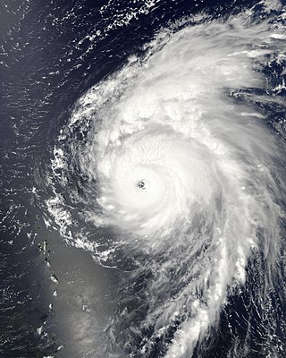
Hurricane Michelle was the fifth costliest tropical cyclone in Cuban history and the strongest hurricane of the 2001 Atlantic hurricane season. The thirteenth named storm and seventh hurricane that year, Michelle developed from a tropical wave that had traversed into the western Caribbean Sea on October 29; the wave had initially moved off the coast of Africa 13 days prior. In its early developmental stages, the depression meandered over Nicaragua, later paralleling the Mosquito Coast before intensifying into tropical storm intensity on November 1; Michelle was upgraded to hurricane strength the following day. Shortly after, rapid intensification ensued within favorable conditions, with the storm's central barometric pressure dropping 51 mbar in 29 hours. After a slight fluctuation in strength, Michelle reached its peak intensity as a Category 4 hurricane with winds of 140 mph (230 km/h) and a minimum pressure of 933 mbar. This tied Michelle with 1999's Lenny as the fourth most powerful November hurricane on record in the Atlantic Basin, behind only the 1932 Cuba hurricane and 2020 Hurricanes Iota and Eta. At roughly the same time, the hurricane began to accelerate northeastward; this brought the intense hurricane to a Cuban landfall within the Bay of Pigs later that day. Crossing over the island, Michelle was weakened significantly, and was only a Category 1 hurricane upon reentry into the Atlantic Ocean. The hurricane later transitioned into an extratropical cyclone over The Bahamas on November 5, before being absorbed by a cold front the following day.

<span class="mw-page-title-main">Hurricane Noel</span> Category 1 Atlantic hurricane in 2007

Hurricane Noel was a deadly tropical cyclone that carved a path of destruction across the Atlantic Ocean from the Caribbean Sea to Newfoundland in late October 2007. The sixteenth tropical depression, fourteenth named storm, and the sixth hurricane of the 2007 Atlantic hurricane season, Noel formed on October 27 from the interaction between a tropical wave and an upper-level low in the north-central Caribbean. It strengthened to winds of 60 mph (97 km/h) before making landfall on western Haiti and the north coast of eastern Cuba. Noel turned northward, and on November 1, it attained hurricane status. The hurricane accelerated northeastward after crossing the Bahamas, and on November 2, it transitioned into an extratropical cyclone.

<span class="mw-page-title-main">Hurricane Bill (2009)</span> Category 4 Atlantic hurricane in 2009

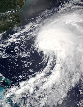
Hurricane Bill was a large Atlantic hurricane that brought minor damage across mainly Atlantic Canada and the East Coast of the United States during August 2009. The second named storm, first hurricane, and first major hurricane of the 2009 Atlantic hurricane season, Bill originated from a tropical wave in the eastern Atlantic on August 15. Initially a tropical depression, the cyclone intensified within a favorable atmospheric environment, becoming Tropical Storm Bill six hours after formation. Steered west-northwest around the southern periphery of a subtropical ridge to the northeast of the cyclone, Bill passed through the central Atlantic. At 0600 UTC on August 17, the cyclone strengthened into a Category 1 hurricane on the Saffir–Simpson hurricane wind scale; within 36 hours, Bill entered a period of rapid deepening and intensified into a major hurricane with winds of 115 mph (185 km/h). Passing well northeast of the Lesser Antilles, Bill attained its peak intensity with maximum sustained winds of 130 mph (215 km/h) and a minimum barometric pressure of 943 mb on August 19 and August 20, respectively. Thereafter, an approaching trough induced higher vertical wind shear across the region, causing slow weakening of the hurricane; this same trough resulted in an accelerated motion and curve northward. As the storm passed Bermuda, it contained sustained winds equal to a Category 2, and ultimately struck Newfoundland as a tropical storm. After moving inland and weakening to a tropical storm, Bill began an extratropical transition; this alteration in structure was completed by 1200 UTC on August 24. Two days later, Bill's remnant low was absorbed into a larger extratropical system over the Northern Atlantic.

<span class="mw-page-title-main">2015 Atlantic hurricane season</span> Hurricane season in the Atlantic Ocean

The 2015 Atlantic hurricane season was the last of three consecutive below average Atlantic hurricane seasons. It produced twelve tropical cyclones, eleven named storms, four hurricanes, and two major hurricanes. The Accumulated Cyclone Energy (ACE) for the season was 68% of the long-term median value. The hurricane season officially began on June 1, 2015, and ended on November 30, 2015. These dates historically describe the period each year when most tropical cyclones form in the North Atlantic basin. However, the first named storm, Ana, developed on May 8, nearly a month before the official start of the season, the first pre-season cyclone since Beryl in 2012 and the earliest since Ana in 2003. The formation of Ana marked the start of a series of seven consecutive seasons with pre-season activity, spanning from 2015 to 2021. The season concluded with Kate transitioning into an extratropical cyclone on November 11, almost three weeks before the official end.

<span class="mw-page-title-main">Tropical Storm Bret (2011)</span> Atlantic tropical storm in 2011

Tropical Storm Bret was the second named storm of the 2011 Atlantic hurricane season. Bret formed along the southwestern periphery of a weather front north of the Bahamas on July 17. At first, the storm moved little and gradually strengthened in response to favorable upper-level conditions, reaching peak sustained winds of 70 mph (110 km/h). Steering currents in the area subsequently became better established, and Bret turned toward the northeast only to encounter a substantial increase in vertical wind shear. Despite the shear, the storm maintained a well-defined wind circulation for several days, with intermittent bursts of thunderstorms near its center. By July 22, Bret had been devoid of strong thunderstorm activity for several hours, prompting the National Hurricane Center to discontinue public advisories when it was located about 375 miles (604 km) north of Bermuda.

<span class="mw-page-title-main">Hurricane Bertha (2014)</span> Category 1 Atlantic hurricane in 2014

Hurricane Bertha was an unusual tropical cyclone in early August 2014 that attained hurricane status, despite having a disheveled appearance and an abnormally high atmospheric pressure. The third tropical cyclone and second hurricane of the season, Bertha developed from a tropical wave south of Cape Verde was monitored first for possible tropical cyclogenesis on July 26. Over the following days, it slowly developed and acquired gale-force winds and enough convection to be designated as Tropical Storm Bertha early on August 1. A mostly disorganized cyclone, Bertha quickly moved across the Lesser Antilles, clipping the northern end of Martinique, later that day. During its trek across the eastern Caribbean Sea, its circulation became severely disrupted and it may have degenerated into a tropical wave. On August 3, it traversed the Mona Passage and moved over the Southeastern Bahamas where conditions favored development. Despite an overall ragged appearance on satellite imagery, data from Hurricane Hunters indicated it intensified to a hurricane on August 4; it acquired peak winds of 80 mph (130 km/h) that day. Turning north, and later northeast, Bertha soon weakened as it began to merge with an approaching trough to the west. This merger ultimately took place on August 6, at which time Bertha was declared extratropical well to the south of Nova Scotia. The remnant system raced eastward across the Atlantic and later struck the United Kingdom on August 10. Once over the North Sea, the storm stalled for a few days before resuming its eastward track. It was last noted around the Baltic Sea on August 16.

<span class="mw-page-title-main">Hurricane Gonzalo</span> Category 4 Atlantic hurricane in 2014

Hurricane Gonzalo was the second tropical cyclone, after Hurricane Fay, to directly strike the island of Bermuda in a one-week time frame in October 2014, and was the first Category 4 Atlantic hurricane since Hurricane Ophelia in 2011. At the time, it was the strongest hurricane in the Atlantic since Igor in 2010. Gonzalo struck Bermuda less than a week after the surprisingly fierce Hurricane Fay; 2014 was the first season in recorded history to feature two hurricane landfalls in Bermuda. A powerful Atlantic tropical cyclone that wrought destruction in the Leeward Islands and Bermuda, Gonzalo was the seventh named storm, sixth and final hurricane and only the second major hurricane of the below-average 2014 Atlantic hurricane season. The storm formed from a tropical wave on October 12, while located east of the Lesser Antilles. It made landfall on Antigua, Saint Martin, and Anguilla as a Category 1 hurricane, causing damage on those and nearby islands. Antigua and Barbuda sustained US$40 million in losses, and boats were abundantly damaged or destroyed throughout the northern Leeward Islands. The storm killed three people on Saint Martin and Saint Barthélemy. Gonzalo tracked northwestward as it intensified into a major hurricane. Eyewall replacement cycles led to fluctuations in the hurricane's structure and intensity, but on October 16, Gonzalo peaked with maximum sustained winds of 145 mph (235 km/h).

<span class="mw-page-title-main">Timeline of the 2015 Atlantic hurricane season</span>

The 2015 Atlantic hurricane season was an event in the annual hurricane season in the north Atlantic ocean.(there were 15 different recorded hurricanes this year). It was the third consecutive year to feature below-average tropical cyclone activity, with eleven named storms. The season officially began on June 1, 2015 and ended on November 30, 2015. These dates, adopted by convention, historically describe the period in each year when most tropical systems form. However, systems can and do form outside these dates, as did the season's first storm, Tropical Storm Ana, which developed on May 8; the season's final storm, Hurricane Kate, lost its tropical characteristics on November 11.

<span class="mw-page-title-main">Hurricane Danny (2015)</span> Category 3 Atlantic hurricane in 2015

Hurricane Danny was the first major hurricane to develop between the Lesser Antilles and Western Africa since Hurricane Julia in 2010. The fourth tropical cyclone, and first hurricane of the 2015 Atlantic hurricane season, Danny originated from a well-defined tropical wave that emerged over the Atlantic Ocean on August 14. Traveling west, the system gradually coalesced into a tropical depression by August 18. After becoming a tropical storm later that day, dry air slowed further development. On August 20–21, dry air became removed from the system, and Danny rapidly intensified into a Category 3 hurricane on the Saffir–Simpson hurricane wind scale. Its peak was short-lived as wind shear soon increased and prompted significant weakening. Degrading to a tropical storm by August 23, Danny approached the Lesser Antilles. It degenerated into a tropical wave as it traversed the archipelago on August 24 and was last noted over Hispaniola the following day.

SS <i>El Faro</i> Rollon-rolloff container ship

SS El Faro was a United States-flagged, combination roll-on/roll-off and lift-on/lift-off cargo ship crewed by U.S. merchant mariners. Built in 1975 by Sun Shipbuilding & Drydock Co. as Puerto Rico, the vessel was renamed Northern Lights in 1991 and, finally, El Faro in 2006. She was lost at sea with her entire crew of 33 on October 1, 2015, after steaming into the eyewall of Hurricane Joaquin.

<span class="mw-page-title-main">Hurricane Beryl</span> Category 1 Atlantic hurricane in 2018

Hurricane Beryl was a fast-moving and long-lived tropical cyclone that formed in the main development region. The second named storm and first hurricane of the 2018 Atlantic hurricane season, Beryl formed from a vigorous tropical wave that moved off the west coast of Africa on July 1. The wave quickly organized into a tropical depression over the central Atlantic Ocean on July 4. Rapid intensification took place and the depression quickly became a tropical storm at 00:00 UTC the next day. Just less than 15 hours later, on July 6, Beryl strengthened into the first hurricane of the season, reaching its peak intensity on July 6. Increasingly unfavorable conditions caused a rapid deterioration of the cyclone shortly after its peak, with Beryl falling to tropical storm status on the next day, as it began to accelerate towards the Caribbean. Late on July 8, it degenerated into a tropical wave shortly before reaching the Lesser Antilles. The remnants were monitored for several days, although they failed to organize significantly until July 14, when it regenerated into a subtropical storm, six days after it lost tropical characteristics. However, the newly reformed storm quickly lost convection, and it degenerated into a remnant low early on July 16, while situated over the Gulf Stream. Beryl subsequently dissipated on the next day.

<span class="mw-page-title-main">Hurricane Dorian</span> Category 5 Atlantic hurricane in 2019

Hurricane Dorian was an extremely powerful and catastrophic Category 5 Atlantic hurricane, which became the most intense tropical cyclone on record to strike the Bahamas, and is tied with the 1935 Labor Day hurricane for the strongest landfall in the Atlantic basin in terms of maximum sustained winds. The 2019 cyclone is regarded as the worst natural disaster in the Bahamas' recorded history. With winds peaking at 185 mph (295 km/h), it was also one of the most powerful hurricanes recorded in the Atlantic Ocean in terms of 1-minute sustained winds, and the strongest since Wilma in 2005. Dorian was the fourth named storm, second hurricane, the first major hurricane, and the first Category 5 hurricane of the 2019 Atlantic hurricane season. Dorian struck the Abaco Islands on September 1 with maximum sustained winds of 185 mph (295 km/h), tying with the 1935 Labor Day hurricane for the highest wind speeds of an Atlantic hurricane ever recorded at landfall. Dorian went on to strike Grand Bahama at similar intensity, stalling just north of the territory with unrelenting winds for at least 24 hours. The resultant damage to these islands was catastrophic; most structures were flattened or swept to sea, and at least 70,000 people were left homeless. After it ravaged through the Bahamas, Dorian proceeded along the coasts of the Southeastern United States and Atlantic Canada, leaving behind considerable damage and economic losses in those regions.

<span class="mw-page-title-main">Hurricanes in the Bahama Archipelago</span>

The Bahama Archipelago, also known as the Lucayan Archipelago, is an island group comprising the Commonwealth of The Bahamas and the British Overseas Territory of the Turks and Caicos Islands. The archipelago is in the western North Atlantic Ocean, north of Cuba along with the other Antilles, and east and southeast of Florida. The archipelago has experienced the effects of at least 22 Atlantic hurricanes, or storms that were once tropical or subtropical cyclones, including 17 since 2000. The storms collectively killed 101 people.

<span class="mw-page-title-main">Hurricane Epsilon (2020)</span> Category 3 Atlantic hurricane in 2020

Hurricane Epsilon was a strong tropical cyclone that affected Bermuda, and parts of North America and Western Europe. The twenty-seventh tropical or subtropical cyclone, twenty-sixth named storm, eleventh hurricane, and fourth major hurricane of the extremely-active 2020 Atlantic hurricane season, Epsilon had a non-tropical origin, developing from an upper-level low off the East Coast of the United States on October 13. The low gradually organized, becoming Tropical Depression Twenty-Seven on October 19, and six hours later, Tropical Storm Epsilon. The storm executed a counterclockwise loop before turning westward, while strengthening. On October 20, Epsilon began undergoing rapid intensification, becoming a Category 1 hurricane on the next day, before peaking as a Category 3 major hurricane on October 22, with maximum 1-minute sustained winds of 115 mph (185 km/h) and a minimum central pressure of 952 millibars (28.1 inHg). This made Epsilon the easternmost major hurricane this late in the calendar year, as well as the strongest late-season major hurricane in the northeastern Atlantic, and the fastest recorded case of a tropical cyclone undergoing rapid intensification that far northeast that late in the hurricane season. Afterward, Epsilon began to weaken as the system turned northward, with the storm dropping to Category 1 intensity late that day. Epsilon maintained its intensity as it moved northward, passing to the east of Bermuda. On October 24, Epsilon turned northeastward and gradually accelerated, before weakening into a tropical storm on the next day. On October 26, Epsilon transitioned into an extratropical cyclone, before being absorbed by another larger extratropical storm later that same day.

<span class="mw-page-title-main">Tropical Storm Alex (2022)</span> Atlantic tropical storm in 2022

Tropical Storm Alex was a strong tropical cyclone that caused flash flooding in western Cuba and South Florida while developing into the first named storm of the 2022 Atlantic hurricane season. Alex originated from a broad area of low pressure partially related to the remnants of Hurricane Agatha in the Eastern Pacific. The National Hurricane Center (NHC) initiated advisories on it as Potential Tropical Cyclone One over the eastern Yucatán Peninsula on June 2. Wind shear and dry air kept the system disorganized until after it crossed Florida two days later. Finally, on June 5, the system became sufficiently organized and was named Alex while located north of Grand Bahama Island. Later that same day, Alex's winds briefly strengthened to 70 mph (110 km/h). The storm brought rain and strong winds to Bermuda on June 6, before becoming a post-tropical cyclone that same day. Alex formed four days after the official start of the season, making the 2022 Atlantic hurricane season the first since 2014 not to have a pre-season named storm.

<span class="mw-page-title-main">Hurricane Nicole (2022)</span> Category 1 Atlantic hurricane in 2022

Hurricane Nicole was a sprawling late-season Category 1 hurricane in November 2022. The fourteenth named storm and eighth hurricane of the 2022 Atlantic hurricane season, Nicole formed as a subtropical cyclone on November 7, from a non-tropical area of low pressure near the Greater Antilles, and transitioned into a tropical cyclone the next day. Then, taking a path similar to that of Hurricane Dorian three years earlier, Nicole made landfall on November 9, on Great Abaco and on Grand Bahama in The Bahamas, where it strengthened into a Category 1 hurricane. On November 10, it made landfall twice in Florida, south of Vero Beach and then northwest of Cedar Key, after briefly emerging over the Gulf of Mexico. Nicole then weakened to a depression while moving over the Florida Panhandle, and then was absorbed into a mid-latitude trough and cold front over extreme eastern Tennessee the following day.

References

  1. "Atlantic Basin Storm Name Pronunciations: 2015–2020" (PDF). Miami, Florida: National Hurricane Center. 2015. Archived from the original (PDF) on December 20, 2015. Retrieved October 1, 2015.
  2. Robbie Berg (January 12, 2016). Tropical Cyclone Report: Hurricane Joaquin 2015 (PDF) (Technical report). United States National Hurricane Center. Retrieved May 17, 2017.
  3. McNoldy, Brian (October 12, 2015). "Hurricane season remains a quiet one, despite Joaquin's alarming adventure". Washington Post. Retrieved October 12, 2015.
  4. 1 2 Government of the Bahamas (October 20, 2016). "PM Christie: Hurricanes Matthew and Joaquin Losses Estimated in Hundreds of Millions". Relief Web. Retrieved October 29, 2016.
  5. 1 2 Government of the Bahamas (April 5, 2016). "Review of the Past Hurricane Season". The Tribune. Retrieved April 6, 2016.
  6. Haff, Sally; Britter, Robert; Jarvinen, Brian. "The Deadliest Atlantic Tropical Cyclones, 1492-1996". National Hurricane Center. Retrieved November 6, 2016.
  7. Eric S. Blake (September 25, 2015). Tropical Weather Outlook (.TXT) (Report). Miami, Florida: National Hurricane Center. Retrieved October 1, 2015.
  8. Michael J. Brennan (September 26, 2015). Tropical Weather Outlook (.TXT) (Report). Miami, Florida: National Hurricane Center. Retrieved October 1, 2015.
  9. Stacy R. Stewart (September 27, 2015). Tropical Weather Outlook (.TXT) (Report). Miami, Florida: National Hurricane Center. Retrieved September 30, 2015.
  10. 1 2 Todd L. Kimberlain (September 28, 2015). Tropical Depression Eleven Discussion Number 1 (Report). Miami, Florida: National Hurricane Center. Retrieved October 1, 2015.
  11. Todd L. Kimberlain (September 28, 2015). Tropical Depression Eleven Advisory Number 1 (Advisory). Miami, Florida: National Hurricane Center. Retrieved October 1, 2015.
  12. Todd L. Kimberlain (September 28, 2015). Tropical Depression Eleven Discussion Number 3 (Report). Miami, Florida: National Hurricane Center. Retrieved October 1, 2015.
  13. 1 2 John P. Cangialosi (September 29, 2015). Tropical Storm Joaquin Discussion Number 5 (Report). Miami, Florida: National Hurricane Center. Retrieved October 1, 2015.
  14. John P. Cangialosi (September 29, 2015). Tropical Storm Joaquin Advisory Number 5 (Advisory). Miami, Florida: National Hurricane Center. Retrieved October 1, 2015.
  15. Richard J. Pasch; James C. Hayes (September 28, 2015). Tropical Depression Eleven Discussion Number 4 (Report). Miami, Florida: National Hurricane Center. Retrieved October 1, 2015.
  16. Michael J. Brennan (September 29, 2015). Tropical Storm Joaquin Discussion Number 6 (Report). Miami, Florida: National Hurricane Center. Retrieved October 1, 2015.
  17. Richard J. Pasch (September 29, 2015). Tropical Storm Joaquin Discussion Number 8 (Report). Miami, Florida: National Hurricane Center. Retrieved September 30, 2015.
  18. Daniel P. Brown (September 30, 2015). Tropical Storm Joaquin Discussion Number 9 (Report). Miami, Florida: National Hurricane Center. Retrieved September 30, 2015.
  19. Jack L. Beven (September 28, 2015). "Hurricane Joaquin Public Advisory Number 10-A" (Advisory). Miami, Florida: National Hurricane Center. Retrieved September 30, 2015.
  20. Daniel P. Brown (October 1, 2015). Hurricane Joaquin Discussion Number 13 (Report). Miami, Florida: National Hurricane Center. Retrieved October 1, 2015.
  21. 1 2 3 4 Berg, Robbie. "Hurricane Joaquin Tropical Cyclone Report" (PDF). National Hurricane Center. Retrieved January 15, 2016.
  22. Jack L. Beven (October 1, 2015). Hurricane Joaquin Discussion Number 16 (Report). Miami, Florida: National Hurricane Center. Retrieved October 1, 2015.
  23. Jeff Masters; Bob Henson (October 1, 2015). "Category 4 Joaquin Pounds the Bahamas; a U.S. Landfall Unlikely". Weather Underground. Retrieved October 1, 2015.
  24. Jack L. Beven (October 1, 2015). Hurricane Joaquin Advisory Number 16 (Advisory). Miami, Florida: National Hurricane Center. Retrieved October 1, 2015.
  25. 1 2 Daniel P. Brown; Stacy R. Stewart (October 2, 2015). Hurricane Joaquin Advisory Number 16A (Report). Miami, Florida: National Hurricane Center. Retrieved October 3, 2015.
  26. Daniel P. Brown (October 2, 2015). Hurricane Joaquin Discussion Number 17 (Report). Miami, Florida: National Hurricane Center. Retrieved October 3, 2015.
  27. 1 2 Jack L. Beven (October 2, 2015). Hurricane Joaquin Discussion Number 19 (Report). Miami, Florida: National Hurricane Center. Retrieved October 3, 2015.
  28. Michael J. Brennan (October 2, 2015). Hurricane Joaquin Discussion Number 18 (Report). Miami, Florida: National Hurricane Center. Retrieved October 3, 2015.
  29. Jack L. Beven (October 2, 2015). Hurricane Joaquin Discussion Number 20 (Report). Miami, Florida: National Hurricane Center. Retrieved October 3, 2015.
  30. Lixion A. Avila (October 3, 2015). Hurricane Joaquin Discussion Number 21 (Report). Miami, Florida: National Hurricane Center. Retrieved October 3, 2015.
  31. Michael J. Brennan (October 3, 2015). Hurricane Joaquin Discussion Number 22 (Report). Miami, Florida: National Hurricane Center. Retrieved October 3, 2015.
  32. Lixion A. Avila (October 3, 2015). Hurricane Joaquin Discussion Number 23 (Report). Miami, Florida: National Hurricane Center. Retrieved October 3, 2015.
  33. Lixion A. Avila (October 3, 2015). Hurricane Joaquin Special Discussion Number 24 (Report). Miami, Florida: National Hurricane Center. Retrieved October 3, 2015.
  34. Jack L. Beven (October 4, 2015). Hurricane Joaquin Discussion Number 26 (Report). Miami, Florida: National Hurricane Center. Retrieved October 4, 2015.
  35. Daniel P. Brown (October 4, 2015). Hurricane Joaquin Discussion Number 27 (Report). Miami, Florida: National Hurricane Center. Retrieved October 4, 2015.
  36. Stacy R. Stewart (October 4, 2015). Hurricane Joaquin Discussion Number 28 (Report). Miami, Florida: National Hurricane Center. Retrieved October 4, 2015.
  37. Stacy R. Stewart (October 5, 2015). Hurricane Joaquin Discussion Number 33 (Report). Miami, Florida: National Hurricane Center. Retrieved October 9, 2015.
  38. Eric S. Blake (October 7, 2015). Tropical Storm Joaquin Discussion Number 40 (Report). Miami, Florida: National Hurricane Center. Retrieved October 9, 2015.
  39. Eric S. Blake (October 7, 2015). Tropical Storm Joaquin Discussion Number 41 (Report). Miami, Florida: National Hurricane Center. Retrieved October 9, 2015.
  40. Richard J. Pasch (October 7, 2015). Post-Tropical Cyclone Joaquin Advisory Number 42 (Advisory). Miami, Florida: National Hurricane Center. Retrieved October 8, 2015.
  41. Wetter map met.fu-berlin.de
  42. Wetter map met.fu-berlin.de
  43. Daniel P. Brown (September 30, 2015). Tropical Storm Joaquin Advisory Number 9 (Advisory). Miami, Florida: National Hurricane Center. Retrieved October 1, 2015.
  44. 1 2 Jack L. Beven (October 1, 2015). Hurricane Joaquin Advisory Number 15 (Advisory). Miami, Florida: National Hurricane Center. Retrieved October 1, 2015.
  45. Lixon A. Avila (October 3, 2015). Hurricane Joaquin Advisory Number 22A (Advisory). Miami, Florida: National Hurricane Center. Retrieved October 3, 2015.
  46. "Update – Immediate School Closure for Exuma, Cat Island, San Salvador, and Rum Cay". The Bahamas Weekly. September 30, 2015. Retrieved October 1, 2015.
  47. "Bahamasair cancels flights due to Hurricane Joaquin". The Bahamas Weekly. September 30, 2015. Retrieved October 1, 2015.
  48. Department of Civil Aviation (October 2, 2015). "Bahamas airport closures update – Friday 10pm". The Bahamas Weekly. Retrieved October 2, 2015.
  49. Nico Scavella (October 2, 2015). "All Cruise Ships Diverted Due To Hurricane Joaquin". The Tribune. Retrieved October 2, 2015.
  50. 1 2 Ben Fox; Tony Winton; Ava Turnquest (September 30, 2015). "Hurricane Joaquin Gains Force Near Bahamas, Heads Toward US". ABC News. Associated Press. Retrieved October 1, 2015.
  51. 1 2 "Prime Minister Christie to Address The Nation with NEMA at Press Briefing Today". The Bahamas Weekly. October 1, 2015. Retrieved October 1, 2015.
  52. 1 2 Sancheska Brown (October 1, 2015). "Rising Floodwaters Trap Residents In Southern Bahamas Islands". The Tribune. Archived from the original on October 1, 2015. Retrieved October 1, 2015.
  53. "Hurricane Joaquin Destroys Buildings, Unleashes Flooding Throughout Friday". The Tribune. October 2, 2015. Archived from the original on October 4, 2015. Retrieved October 2, 2015.
  54. "Hurricane Joaquin Air Travel and Cruise Updates". The New York Times. October 2, 2015. Retrieved October 2, 2015.
  55. Jack L. Beven (October 2, 2015). Tropical Storm Joaquin Advisory Number 18A (Advisory). Miami, Florida: National Hurricane Center. Retrieved October 3, 2015.
  56. Darcy Spencer (September 30, 2015). "Hurricane Joaquin: Virginia Declares State of Emergency". WRC-TV . NBCUniversal . Retrieved October 1, 2015.
  57. "Joaquin has been upgraded to a major category 3 hurricane". WVEC . Norfolk, Virginia: Tegna, Inc. September 30, 2015. Archived from the original on October 3, 2015. Retrieved October 1, 2015.
  58. Jim McKeever (September 30, 2015). "State gives residents preparation tips for hurricanes as Joaquin nears". WTIC-TV . Hartford, Connecticut: Tribune Media. Archived from the original on October 1, 2015. Retrieved October 1, 2015.
  59. Governor's Office (September 30, 2015). "Governor Cuomo Urges New Yorkers to be Prepared For Heavy Rains, Potential Tropical Storm Conditions and Flooding". State of New York. Archived from the original on August 10, 2021. Retrieved October 2, 2015.
  60. "Christie Declares State of Emergency in New Jersey Ahead of Hurricane Joaquin". WPVI-TV . Trenton, New Jersey: American Broadcasting Company. October 1, 2015. Retrieved October 1, 2015.
  61. "Mandatory evacuation declared for Ocracoke Island". WNCT-TV . Sqan Quarter, North Carolina: Media General. October 1, 2015. Archived from the original on October 2, 2015. Retrieved October 1, 2015.
  62. Andrew Albert (October 1, 2015). "Bike MS: City to Shore cancelled". Press of Atlantic City. Retrieved October 1, 2015.
  63. Jack L. Beven (October 2, 2015). "Hurricane Joaquin Advisory Number 20". National Hurricane Center. Retrieved October 2, 2014.
  64. Jack L. Beven (October 3, 2015). "Hurricane Joaquin Advisory Number 26". National Hurricane Center. Retrieved October 3, 2014.
  65. "Regiment Soldiers On Alert For Hurricane". Bernews. October 2, 2015. Retrieved October 2, 2015.
  66. Lisa Simpson (October 4, 2015). "Causeway to close". The Royal Gazette. Retrieved October 4, 2015.
  67. Jonathon Bell (October 5, 2015). "Causeway open, gas station break-in". The Royal Gazette. Retrieved October 5, 2015.
  68. "Cruises Cancelled Due To Hurricane Joaquin". Bernews. October 3, 2015. Retrieved October 3, 2015.
  69. "Live Updates: Hurricane Joaquin Approaches". Bernews. October 4, 2015. Retrieved October 4, 2015.
  70. Bahamas Telecommunications Company (October 1, 2015). "BTC Updates on Hurricane Joaquin". The Bahamas Weekly. Retrieved October 1, 2015.
  71. "Communication With Storm-Hit Islands A Challenge". The Tribune. October 2, 2015. Retrieved October 2, 2015.
  72. 1 2 3 Krishna Virgil (October 22, 2015). "Hurricane Wiped Out 836 Homes". The Tribune. Archived from the original on January 29, 2016. Retrieved October 24, 2015.
  73. Sancheska Brown (October 22, 2015). "Bec Restores Power To 80% Of Affected Homes". The Tribune. Retrieved October 24, 2015.
  74. 1 2 3 "Hurricane Joaquin Updates: Multiple Deaths Confirmed, Southern Family Islands "Completely Devastated"". The Tribune. October 3, 2015. Retrieved October 3, 2015.
  75. 1 2 Sean Breslin (October 1, 2015). "Hurricane Joaquin's Bahamas Impacts: More Than 500 Residents Trapped in Their Homes, Excessive Power Outages". The Weather Channel. Associated Press. Retrieved October 2, 2015.
  76. 1 2 3 4 5 6 7 8 "Hurricane Joaquin - Situation Report #4 as of 8:00 pm on October 4th, 2015". Caribbean Disaster Emergency Management Agency. October 4, 2015. Retrieved October 5, 2015.
  77. "10,000 Gallons Of Fuel Feared Spilled In Crooked Island". The Tribune. October 26, 2015. Retrieved October 26, 2015.
  78. Khrisna Virgil (October 6, 2015). "46 Evacuated From Crooked Island". The Tribune. Retrieved October 6, 2015.
  79. Nico Scavella (October 9, 2015). "Nearly 100 Evacuated From Hurricane-Hit Islands This Week". The Tribune. Retrieved October 24, 2015.
  80. 1 2 3 4 5 "Hurricane Joaquin - Situation Report #5 as of 6:00 pm on October 7th, 2015". Caribbean Disaster Emergency Management Agency. October 7, 2015. Retrieved October 8, 2015.
  81. 1 2 Sancheska Brown (October 15, 2015). "Fishing And Farming Industries Are 'Completely Devastated'". The Tribune. Retrieved October 15, 2015.
  82. 1 2 "Loretta Butler-Turner on Long Island post-hurricane Joaquin". The Tribune. October 3, 2015. Retrieved October 4, 2015.
  83. "Long Islanders Tell Of 'The Worst Storm They Have Ever Seen'". The Tribune. October 2, 2015. Retrieved October 2, 2015.
  84. "Appeal For Emergency Long Island Supplies For Early Sunday Morning". The Tribune. October 3, 2015. Retrieved October 3, 2015.
  85. 1 2 National Emergency Management Agency (October 2, 2015). "NEMA Update: Bahamas Islands affected by Hurricane Joaquin". The Bahamas Weekly. Retrieved October 2, 2015.
  86. Krystel Rolle-Brown (October 3, 2015). "Devastated: Joaquin leaves path of destruction in its wake". The Nassau Guardian. Retrieved October 3, 2015.
  87. 1 2 International Federation of Red Cross And Red Crescent Societies (October 21, 2015). "Bahamas Red Cross Responds to Hurricane Joaquin". ReliefWeb. Retrieved October 27, 2015.
  88. Ian Livingston (October 2, 2015). "Hurricane Joaquin among the strongest storms on record in the Bahamas". Capital Weather Gang. The Washington Post. Retrieved October 4, 2015.
  89. "Updated: Storm Compared To Hurricane Andrew". The Tribune. October 3, 2015. Retrieved October 3, 2015.
  90. "No Deaths In Long Island From Storm, Says Police Chief". The Tribune. October 5, 2015. Retrieved October 5, 2015.
  91. Neil Hartnell (October 28, 2015). "Joaquin Set To Cost Insurers $25-$30m". The Tribune. Retrieved October 28, 2015.
  92. "After destruction in Bahamas, relief efforts commence as Hurricane Joaquin threatens Bermuda". Miami Herald. October 4, 2015. Retrieved October 4, 2015.
  93. "International Community Rallies To Support Bahamas After Storm". The Tribune. October 4, 2015. Retrieved October 4, 2015.
  94. Stephen Hunt (October 4, 2015). "How To Help: Guide To The Relief Efforts Following Joaquin". The Tribune. Retrieved October 4, 2015.
  95. "BTC Opens Call Centres for Joaquin Affected Islands". The Bahamas Weekly. October 5, 2015. Retrieved October 5, 2015.
  96. Khrisna Virgil (October 15, 2015). "Call To Build In Elevated Areas". The Tribune. Retrieved October 15, 2015.
  97. Krishna Virgil (October 21, 2015). "Gray Says Government Will Rebuild Homes Where Necessary". The Tribune. Archived from the original on March 27, 2019. Retrieved October 24, 2015.
  98. Ricardo Wells (October 24, 2015). "Butler-Turner Insists That Long Island Will Recover". The Tribune. Retrieved October 24, 2015.
  99. Neil Hartnell (October 6, 2015). "Club Med Postpones Re-Open By 2 Months". The Tribune. Retrieved October 6, 2015.
  100. Nico Scavella (October 28, 2015). "Nema Expects To Begin Repairs On November 2". The Tribune. Retrieved October 28, 2015.
  101. "El Faro (7500285)". ABS Record. American Bureau of Shipping . Retrieved October 10, 2015.
  102. 1 2 3 "Coast Guard searching for missing cargo ship out of Jacksonville". WJAX-TV . Jacksonville, Florida: Cox Media Group. October 2, 2015. Archived from the original on October 7, 2015. Retrieved October 8, 2015.
  103. "Hurricane Joaquin Destroys Buildings, Unleashes Flooding Throughout Friday". The Tribune. October 2, 2015. Archived from the original on October 4, 2015. Retrieved October 3, 2015.
  104. 1 2 "Objects Found in Search for US Cargo Ship El Faro Missing in Hurricane Joaquin". ABC News . The Walt Disney Company. October 4, 2015. Retrieved October 4, 2015.
  105. Jenny Staletovich; Jacqueline Charles (October 3, 2015). "Joaquin pulls away from Bahamas; ship still missing at sea". Miami Herald. Retrieved October 3, 2015.
  106. Elisha Fieldstadt; Andrew Rudansky; Jason Cumming (October 3, 2015). "No Sign of Cargo Ship El Faro in Wake of Hurricane Joaquin". NBC News . Retrieved October 3, 2015.
  107. United States Coast Guard Southeast [@USCGSoutheast] (October 4, 2015). "#BreakingNews @USCGSoutheast C-130 just lands, reports 225 SqMi debris field of styrofoam, wood, cargo, other items" (Tweet). Retrieved October 4, 2015 via Twitter.
  108. Emily Reiter (October 7, 2015). "Coast Guard to suspend search for El Faro crew after 7-day search". United States Coast Guard . Miami, Florida: TOTE Maritime. Archived from the original on December 8, 2015. Retrieved October 10, 2015.
  109. Eliott C. McLaughlin; Kevin Conlon (October 5, 2015). "Coast Guard: Missing cargo ship El Faro sank". CNN . Retrieved October 5, 2015.
  110. Jason Dearen; Jennifer Kay (October 5, 2015). "One body found, empty lifeboat located in search for crew of El Faro". The Boston Globe . Jacksonville, Florida: John W. Henry. Associated Press . Retrieved October 10, 2015.
  111. Erik Ortiz; Elisha Fieldstadt (October 5, 2015). "El Faro, Cargo Ship Carrying 28 Americans, Believed to Have Sunk". NBC News . Retrieved October 5, 2015.
  112. Mariano Castillo; Holly Yan; Eliott C. McLaughlin; Steve Almasy (October 7, 2015). "El Faro search ends, Coast Guard says". CNN . Retrieved October 7, 2015.
  113. "Pronóstico de lluvias por huracán Joaquín moviliza a los cubanos". CubaNet (in Spanish). October 2, 2015. Retrieved October 2, 2015.
  114. Darelia Díaz Borrero (October 2, 2015). "Se prepara Granma para reducir efectos del huracán Joaquín" (in Spanish). Bayamo, Cuba: Granma. Retrieved October 3, 2015.
  115. "Huracán Joaquín no provocó en Cuba las lluvias deseadas" (in Spanish). Havana, Cuba: Radio Reloj. Redacción Central. October 6, 2015. Archived from the original on December 8, 2015. Retrieved October 7, 2015.
  116. "Cuba recupera la 'normalidad' mientras el huracán Joaquín se aleja". Diario de Cuba (in Spanish). Havana, Cuba. October 4, 2015. Retrieved October 7, 2015.
  117. Lisván Lescaille Durand; Yahily Hernández Porto; Osviel Castro Medel; Odalis Riquenes Cutiño; Héctor Carballo Hechavarría (October 2, 2015). "Joaquín moja, pero no empapa". Juventud Rebelde (in Spanish). Retrieved October 7, 2015.
  118. 1 2 "Hurricane Joaquin - Situation Report #7 as of 3:30 pm on October 9th 2015". Caribbean Disaster Emergency Management Agency. October 9, 2015. Retrieved October 10, 2015.
  119. "U.S. Coast Guard Rescues 12 From Sinking Cargo Ship". CBS Local Media. October 2, 2015. Retrieved October 8, 2015.
  120. Lisa Simpson; Jonathan Bell (October 4, 2015). "Joaquin passes closest point of approach". The Royal Gazette. Retrieved October 4, 2015.
  121. Jonathan Bell (October 6, 2015). "West End bears the brunt of Joaquin". The Royal Gazette. Retrieved October 6, 2015.
  122. Lisa Simpson (October 8, 2015). "Belco still addressing 14 outages". The Royal Gazette. Retrieved October 9, 2015.
  123. Bermuda Weather Service (October 5, 2015). B (Report). Bermuda: Bermuda Weather Service. Retrieved January 1, 2016.
  124. Bermuda Weather Service (October 6, 2015). "Facebook post on Hurricane Joaquin on Tuesday, October 6, 2015". Bermuda Weather Service official Facebook page. Retrieved October 6, 2015.
  125. Jonathon Bell (October 5, 2015). "Fresh roof damage at Commissioner's Point". The Royal Gazette. Retrieved October 5, 2015.
  126. Jonathon Bell (October 5, 2015). "BF&M: little property damage". The Royal Gazette. Retrieved October 5, 2015.
  127. "Hurricane Joaquin - Situation Report #6 as of 6:00 pm on October 8th, 2015". Caribbean Disaster Emergency Management Agency. October 8, 2015. Retrieved October 5, 2015.
  128. Jeff Halverson (October 5, 2015). "The meteorology behind South Carolina's catastrophic, 1,000-year rainfall event". The Washington Post . Retrieved October 5, 2015.
  129. "S.C. flooding death toll up to 9". WYFF . Hearst Corporation. October 5, 2015. Retrieved October 5, 2015.
  130. "Billion-Dollar Weather and Climate Disasters: Table of Events". NOAA. 2015. Retrieved September 6, 2018.
  131. "World Meteorological Organization retires storm names Erika, Joaquin and Patricia". National Oceanic and Atmospheric Administration. April 25, 2016. Retrieved April 26, 2016.
  132. Rice, Doyle (April 26, 2016). "Hurricane names Patricia, Joaquin and Erika retired". USA Today. Archived from the original on January 23, 2024. Retrieved April 12, 2024.
Hurricane Joaquin
Joaquin 2015-10-03 1437Z.png
Hurricane Joaquin at peak intensity to the northeast of The Bahamas on October 3