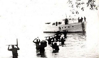
Granma is a yacht that was used to transport 82 fighters of the Cuban Revolution from Mexico to Cuba in November 1956 to overthrow the regime of Fulgencio Batista. The 60-foot diesel-powered vessel was built in 1943 by Wheeler Shipbuilding of Brooklyn, New York, as a light armored target practice boat, US Navy C-1994, and modified postwar to accommodate 12 people. "Granma", in English, is an affectionate term for a grandmother; the yacht is said to have been named for the previous owner's grandmother.

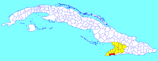
Granma is one of the provinces of Cuba. Its capital is Bayamo. Other towns include Manzanillo and Pilón.

Tuxpan is both a municipality and city located in the Mexican state of Veracruz. The population of the city was 89,557 and of the municipality was 154,600 inhabitants, according to the INEGI census of 2020, residing in a total area of 1,051.89 km2 (406.14 sq mi). The municipality includes many smaller outlying communities, the largest of which are Alto Lucero and Santiago de la Peña. A local beachside community is also nearby.

Manzanillo is a municipality and city in the Granma Province of Cuba. By population, it is the 14th-largest Cuban city and the most populated one not being a provincial seat.

Yara is a small town and municipality in the Granma Province of Cuba, located halfway between the cities of Bayamo and Manzanillo, in the Gulf of Guacanayabo. Yara means "place" in the Taíno language.

Campechuela is a municipality and town in Granma Province of Cuba. It is located on the southern shore of the Gulf of Guacanayabo.

Jiguaní is a town and municipality in the Granma Province of Cuba. It is located 25 kilometres (16 mi) east of Bayamo, the provincial capital.

Desembarco del Granma National Park is a national park in south-western Cuba, stretching across the Niquero and Pilón municipalities in what is now Granma Province. The name of the park means "Landing of the Granma" and refers to the yacht in which Fidel Castro, Che Guevara, Raúl Castro, and 79 of their supporters sailed from Mexico to Cuba in 1956 and incited the Cuban Revolution. The National park is well known for its karst topography and coastal cliffs.

Sandino is a municipality and town in the Pinar del Río Province of Cuba. The town is located close to the coast and as such, fishing is the main economic resource of this place. It is also the gateway to the Guanahacabibes Peninsula, a UNESCO Biosphere Reserve.
Contramaestre is a Cuban town and municipality in the Santiago de Cuba Province.

Urbano Noris is a municipality and city in the Holguín Province of Cuba. The municipal seat is located in the town of San Germán.
Pilón is a municipality and town in the Granma Province of Cuba. It is located on the southern coast of Cuba, in an inlet of the Caribbean Sea.
Bartolomé Masó is a municipality and town in the Granma Province of Cuba.

Cauto Cristo is a municipality and town in the Granma Province of Cuba. It is located on the banks of the Río Cauto, in the western part of the province, bordering the provinces of Holguín and Las Tunas.

Guisa is a municipality and town in the Granma Province of Cuba. It is located 19 kilometres (12 mi) south-east of Bayamo, the provincial capital.

Media Luna is a town and municipality in the Granma Province of Cuba. It is located on the coastal region of the province, bordering the Gulf of Guacanayabo, between Niquero and Campechuela.

Río Cauto is a municipality and town in the Granma Province of Cuba. It is located in the northern part of the province, upstream of the mouth of Cauto River.
Norberto Collado Abreu was the Cuban captain and helmsman of the yacht Granma, which brought Fidel Castro and 81 other rebels to Cuba from Tuxpan, Veracruz, Mexico, in 1956. The 1956 landing of Castro from the Granma in eastern Cuba began the Cuban Revolution which resulted in the termination of President Fulgencio Batista's government in 1959.
Cape Cruz,, is a cape that forms the western extremity of the Granma Province in southern Cuba. It extends into the Caribbean sea and marks the eastern border of the Gulf of Guacanayabo. Cape Cruz is located in the municipality of Niquero and is part of the Desembarco del Granma National Park.

The Circuito Sur de Oriente (CSO), meaning "Southern Circuit of the Orient", is a west-east highway connecting Bayamo to Santiago de Cuba, through Manzanillo, Niquero and the southern coastal side of eastern Cuba, below the Sierra Maestra mountain range. Also known as Circuito Guacanayabo-Sur de Oriente, because it crosses the Gulf of Guacanayabo, the name Oriente, refers to the ancient and former Oriente Province. With a length of 347 km, it is the fourth-longest Cuban highway after the "Carretera Central", the "Circuito Norte" and the "Circuito Sur".

