Manzanillo, Cuba

Last updated
Manzanillo
Simbolo de la Ciudad (Glorieta).jpg
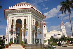
The Glorieta of Manzanillo
Escudo de Armas del Puerto Real de Manzanillo.jpg
Manzanillo (Cuban municipal map).png
Manzanillo municipality (red) within
Granma Province (yellow) and Cuba
Coordinates: 20°20′23″N77°06′31″W / 20.33972°N 77.10861°W / 20.33972; -77.10861
Country Cuba
Province Granma
EstablishedJanuary 6, 1840 [1]
Government
  PresidentRossio Naranjo Figueredo
Area
[2]
  Total498 km2 (192 sq mi)
Elevation
25 m (82 ft)
Population
 (2022) [3]
  Total123,542
  Density250/km2 (640/sq mi)
Demonym Manzanillero/a
Time zone UTC-5 (EST)
Postal code
87510
Area code +53 23
Website https://www.manzanillo.gob.cu/es/

Manzanillo is a municipality and city in the Granma Province of Cuba. By population, it is the 14th-largest Cuban city and the most populated one not being a provincial seat.

Contents

Geography

It is a port city in the Granma Province in eastern Cuba on the Gulf of Guacanayabo, near the delta of the Cauto River. Access by sea is limited by the coral reefs of Cayo Perla.[ citation needed ]

The municipality is divided into the barrios of Primero, Segundo, Tercero, Cuarto, Quinto y Sexto (part of the city of Manzanillo), as well as the rural communities of Blanquizal, Calicito, Canabacoa, Caño, Ceiba Caridad, Congo, Jibacoa, Palmas Altas, Purial, Remate, Tranquilidad and Zarzal. [1]

History

Manzanillo was founded in 1784. [4] [5] The settlement was sacked by the French in 1792, and in the following year a fort was built for its protection. [5] In 1833 it received an ayuntamiento (council) and in 1837, for its "loyalty" in not following the lead of Santiago in proclaiming the Spanish Constitution, received from the crown the title of Fiel. [5] In 1827 the port was opened to commerce, national and foreign. [5] It was the site of three battles during the Spanish–American War.

Economy

Local agriculture is based on raising coffee, sugarcane, [5] rice, fruit and tobacco [5] crops, as well as honey and cattle.

Local industry is composed of sawmills, fish-canning, molasses plants, as well as some cigar and leather goods factories. [4]

Zinc and copper deposits are present in the municipality.

Demographics

In 2022, the municipality of Manzanillo had a population of 123,542. [3] With a total area of 498 km2 (192 sq mi), [2] it has a population density of 250/km2 (650/sq mi).

Culture

Manzanillo is also home of the medical science faculty of the University of Granma.

Transport

The city is crossed by the state highway Circuito Sur de Oriente (CSO) and by the highway 17 to Las Tunas. The railway station is the western terminus of a line from Bayamo, and is served by regional and long-distance trains, the latter linking the city with Santiago de Cuba, Guantánamo, Camagüey, Ciego de Ávila, Santa Clara and Havana.

Personalities

See also

Related Research Articles

<span class="mw-page-title-main">Provinces of Cuba</span> Administrative divisions of Cuba

Administratively, Cuba is divided into 15 provinces and one special municipality. The current structure has been in place since August 2010, when the then-La Habana Province was divided into Artemisa Province and Mayabeque Province.

<span class="mw-page-title-main">Santiago de Cuba Province</span> Province of Cuba

Santiago de Cuba Province is the second most populated province in the island of Cuba. The largest city Santiago de Cuba is the main administrative center. Other large cities include Palma Soriano, Contramaestre, San Luis and Songo-la Maya.

<span class="mw-page-title-main">Holguín Province</span> Province of Cuba

Holguín is one of the provinces of Cuba, the third most populous after Havana and Santiago de Cuba. It lies in the southeast of the country. Its major cities include Holguín, Banes, Antilla, Mayarí, and Moa.

<span class="mw-page-title-main">Granma Province</span> Province of Cuba

Granma is one of the provinces of Cuba. Its capital is Bayamo. Other towns include Manzanillo and Pilón.

<span class="mw-page-title-main">Bayamo</span> Municipality in Granma, Cuba

Bayamo is the capital city of the Granma Province of Cuba and one of the largest cities in the Oriente region.

<span class="mw-page-title-main">Palma Soriano</span> District in Oriente, Cuba

Palma Soriano is a Cuban city and municipality in the Santiago de Cuba Province. With a population of 119,740 in the city proper, it is the second-largest in the province and the 16th-largest in Cuba.

<span class="mw-page-title-main">Las Tunas (city)</span> Municipality in Las Tunas, Cuba

Las Tunas is a city and municipality in central-eastern Cuba. It is the capital of the Las Tunas Province and was named Victoria de Las Tunas from 1869 to 1976.

<span class="mw-page-title-main">Yara, Cuba</span> Municipality in Granma, Cuba

Yara is a small town and municipality in the Granma Province of Cuba, located halfway between the cities of Bayamo and Manzanillo, in the Gulf of Guacanayabo. Yara means "place" in the Taíno language.

<span class="mw-page-title-main">Florida, Cuba</span> Municipality in Camagüey, Cuba

Florida is a municipality and city in the Camagüey Province of Cuba. It is located 40 km (25 mi) north-west of Camagüey, along the Carretera Central highway. The city was established in 1907, and the municipality was established in 1924. Of all the municipalities of the Cuban province of Camagüey, Florida is third in area size. The name is Spanish for Land of flowers.

<span class="mw-page-title-main">Campechuela</span> Municipality in Granma, Cuba

Campechuela is a municipality and town in Granma Province of Cuba. It is located on the southern shore of the Gulf of Guacanayabo.

<span class="mw-page-title-main">Jiguaní</span> Municipality in Granma, Cuba

Jiguaní is a town and municipality in the Granma Province of Cuba. It is located 25 kilometres (16 mi) east of Bayamo, the provincial capital.

<span class="mw-page-title-main">Cacocum</span> Municipality in Holguín, Cuba

Cacocum is a municipality and town in the Holguín Province of Cuba.

<span class="mw-page-title-main">Guamá, Cuba</span> Municipality in Santiago de Cuba, Cuba

Guamá is a municipality in the Santiago de Cuba Province of Cuba. The municipal seat is located in the town of Chivirico. It was named after Guamá, the Taíno cacique who led a rebellion against the Spanish 1530s.

<span class="mw-page-title-main">Tercer Frente</span> Municipality in Santiago de Cuba, Cuba

Tercer Frente is a municipality in the Santiago de Cuba Province of Cuba. It is centered on the town, and municipal seat, of Cruce de los Baños.

<span class="mw-page-title-main">Contramaestre, Cuba</span> Municipality in Santiago de Cuba, Cuba

Contramaestre is a Cuban town and municipality in the Santiago de Cuba Province.

<span class="mw-page-title-main">Urbano Noris</span> Municipality in Holguín, Cuba

Urbano Noris is a municipality and city in the Holguín Province of Cuba. The municipal seat is located in the town of San Germán.

<span class="mw-page-title-main">Pilón, Cuba</span> Municipality in Granma, Cuba

Pilón is a municipality and town in the Granma Province of Cuba. It is located on the southern coast of Cuba, in an inlet of the Caribbean Sea.

<span class="mw-page-title-main">Bartolomé Masó, Cuba</span> Municipality in Granma, Cuba

Bartolomé Masó is a municipality and town in the Granma Province of Cuba.

<span class="mw-page-title-main">Media Luna, Cuba</span> Municipality in Granma, Cuba

Media Luna is a town and municipality in the Granma Province of Cuba. It is located on the coastal region of the province, bordering the Gulf of Guacanayabo, between Niquero and Campechuela.

<span class="mw-page-title-main">Niquero</span> Municipality in Granma, Cuba

Niquero is a municipality and town in the Granma Province of Cuba. It is located in the coastal region of the province, bordering the Gulf of Guacanayabo. Cape Cruz, the westernmost point of the province is located in this municipality.

References

  1. 1 2 Guije.com. "Manzanillo" (in Spanish). Retrieved 2007-10-06.
  2. 1 2 Statoids (July 2003). "Municipios of Cuba" . Retrieved 2007-10-06.
  3. 1 2 "Cuba: Administrative Division (Provinces and Municipalities) - Population Statistics, Charts and Map". www.citypopulation.de. Retrieved 2024-02-03.
  4. 1 2 Encarta (2001). "Manzanillo Info". GreatestCities.com.
  5. 1 2 3 4 5 6 Chisholm, Hugh, ed. (1911). "Manzanillo (Cuba)"  . Encyclopædia Britannica . Vol. 17 (11th ed.). Cambridge University Press. p. 626.

Commons-logo.svg Media related to Manzanillo, Cuba at Wikimedia Commons