Greater Antilles

Last updated

Greater Antilles
Grandes Antilles (French)
Antillas Mayores (Spanish)
Map of the Caribbean-Greater Antilles.png
Location within the Caribbean
Island States
Area
  Total207,411 km2 (80,081 sq mi)
Population
 (2014)
  Total38,400,500
  Density171.45/km2 (444.1/sq mi)
Demonym Greater Antillean
Time zone EST: UTC-5/EDT: UTC-4 AST: UTC-4/ADT: UTC-3

The Greater Antilles [1] is a grouping of the larger islands in the Caribbean Sea, including Cuba, Hispaniola, Puerto Rico, Jamaica, Navassa Island, and the Cayman Islands. Six island states share the region of the Greater Antilles, with Haiti and the Dominican Republic sharing the island of Hispaniola. Together with the Lesser Antilles, they make up the Antilles, which along with the Lucayan Archipelago, form the West Indies.

Contents

Havana Cathedral, built by the Spanish in Cuba between 1748 and 1777 Cathedral (3209489947).jpg
Havana Cathedral, built by the Spanish in Cuba between 1748 and 1777

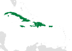
While most of the Greater Antilles consists of independent countries, Puerto Rico is an unincorporated territory of the United States, while the Cayman Islands are a British Overseas Territory. The largest island by area is Cuba, which extends to the western end of the island group. Puerto Rico lies on the eastern end, and the island of Hispaniola, the largest island by population, is located in the middle. Jamaica lies to the south of Cuba, while the Cayman Islands are located to the west. The state of Florida is the closest point in the U.S mainland to the Greater Antilles, while the Florida Keys, though not part of the Greater Antilles, is an island group north of Cuba.

Puerto Rico's historic district, Old San Juan, contains 16th-century architecture, including the Fort San Felipe del Morro, the Fort San Cristobal, the City Wall of San Juan, and La Fortaleza. Puerta San Juan SJU 06 2019 8631.jpg
Puerto Rico’s historic district, Old San Juan, contains 16th-century architecture, including the Fort San Felipe del Morro, the Fort San Cristóbal, the City Wall of San Juan, and La Fortaleza.

History

The word Antilles originated in the period before the European conquest of the New World. Europeans used the term Antillia as one of the mysterious lands featured on medieval charts, sometimes as an archipelago, sometimes as continuous land of greater or lesser extent, its location fluctuating mid-ocean between the Canary Islands and Eurasia. The first European contact with the Greater Antilles came from Christopher Columbus' first voyage to the Americas, as he sailed south from the Bahamas, exploring the northeast coast of Cuba and northern coast of Hispaniola. The Spanish began to create permanent settlements on Cuba and Hispaniola. The Atlantic slave trade brought many Africans to the islands. France began to exert influence over Haiti from 1625, dividing Hispaniola into two halves. Neighbouring Jamaica was invaded by the British, defeating the Spanish colonists.

At the beginning of the 16th century, the Spanish began to colonize the island of Puerto Rico. Despite the Laws of Burgos of 1512 and other decrees protecting indigenous populations, some Taíno Indians were forced into an encomienda system of forced labor in the early years of colonization.

The Haitian Revolution was the first and only successful anti-slavery and anti-colonial insurrection by self-liberated slaves; it established the independent nation of Haiti, the first in the Greater Antilles, the Caribbean, and Latin America as a whole. [2] The next nation to achieve independence, the Dominican Republic, was also on Hispaniola, declaring independence from Spain in 1821. It was quickly absorbed by Haiti under the Unification of Hispaniola.

Citadelle Laferriere, 19th-century fortress in Haiti. It was built by freed slaves as a defence against France Citadelle Laferriere Aerial View.jpg
Citadelle Laferrière, 19th-century fortress in Haiti. It was built by freed slaves as a defence against France

The Dominican Republic regained independence in 1844 after the Dominican War of Independence. The rest of the Greater Antilles would remain under colonial rule for another hundred years. Along with the Philippines in Asia, Spain transferred possession of Cuba and Puerto Rico to the United States as a result of its loss in the Spanish-American War in 1898, coinciding with the Cuban War of Independence. This was the final loss of Spain's territorial possessions in the Americas. U.S. military rule over the island lasted until 1902, when Cuba was granted formal independence.

In 1917, the U.S. Congress passed the Jones–Shafroth Act (popularly known as the Jones Act), granting U.S. citizenship to Puerto Ricans born on or after April 25, 1898. In 1947, the U.S. Congress passed the Elective Governor Act, signed by President Truman, allowing Puerto Ricans to vote for their own governor. The Cuban Revolution in 1959 established Cuba as the only socialist state in the Greater Antilles. [3] Jamaica was granted independence from the U.K in August 1962 becoming the last currently independent state in the Greater Antilles to achieve independence.

Geography

Punta Cana, Dominican Republic Punta Cana.jpg
Punta Cana, Dominican Republic

The Greater Antilles comprises four major islands and numerous smaller ones. The island of Cuba is the largest island in the Greater Antilles, in Latin America, and in the Caribbean. It is followed by Hispaniola. Geologically, the Virgin Islands are also part of the Greater Antilles, though politically they are considered part of the Lesser Antilles. With an area of 207,411 square kilometres (80,082 sq mi), not counting the Virgin Islands, the Greater Antilles constitute nearly 90% of the land mass of the entire West Indies, [4] as well as over 90% of its population. The remainder of the land belongs to the archipelago of the Lesser Antilles, which is a chain of islands to the east, running north–south and encompassing the eastern edge of the Caribbean Sea where it meets the Atlantic Ocean, as well as to the south, running east–west off the northern coast of South America.

The Lucayan Archipelago is not considered part of the Antilles archipelagos but rather of the North Atlantic.

Ocho Rios, Jamaica Town of Ocho Rios.JPG
Ocho Rios, Jamaica

Demographics

Santurce, the most populated district, or barrio, in Puerto Rico's capital, San Juan. San Juan from above.jpg
Santurce, the most populated district, or barrio, in Puerto Rico’s capital, San Juan.

The Greater Antilles is considered part of Latin America. With a population of 38 million, it makes up 6% of Latin America's total population. The capital of the Dominican Republic, Santo Domingo, with a population of over 2 million, is the largest city in the Greater Antilles. Other large cities include Havana, Port-au-Prince, and San Juan. The quality of life within the Greater Antilles is similar among Cuba, the Dominican Republic and Jamaica, whose Human Development Index categorizes them as "high human development". Cuba, the independent nation with the highest HDI, nevertheless ranks below Puerto Rico and the Cayman Islands, both of which are categorized as "very high". Haiti is an exception, having the lowest Human Development Index in the Greater Antilles and in all of the Americas at 0.498, which categorizes it as having "Low human development". [5]

Languages

Languages spoken in the Greater Antilles are mostly colonial languages, along with some Creole influence. Spanish is the main language in Cuba, the Dominican Republic and Puerto Rico. Haiti has a Creole language, Haitian Creole, as one of its official languages, alongside French. English is the main language in Jamaica and the Cayman Islands, though it is also an official language of Puerto Rico, where it is spoken as a second language. In Jamaica, a Creole language is spoken but carries no official recognition.

List of countries and dependencies

Name Area
(km2)
Population
(2017)
Population density
(per km2)
Capital Official language
Cayman Islands (UK)26458,441207.9 George Town English
Cuba 110,86011,147,407102.4 Havana Spanish
Dominican Republic 48,44210,734,247183.7 Santo Domingo Spanish
Haiti 27,75010,646,714292.7 Port-au-Prince Haitian Creole, French
Jamaica 10,9912,990,561248.6 Kingston English
Puerto Rico (US)9,1043,351,827430.2 San Juan Spanish, English
Total207,41138,929,197169.05

Related Research Articles

<span class="mw-page-title-main">Caribbean Sea</span> Sea of the Atlantic Ocean bounded by North, Central and South America

The Caribbean Sea is a sea of the Atlantic Ocean in the tropics of the Western Hemisphere. It is bounded by Mexico and Central America to the west and southwest, to the north by the Greater Antilles starting with Cuba, to the east by the Lesser Antilles, and to the south by the northern coast of South America. The Gulf of Mexico lies to the northwest.

<span class="mw-page-title-main">Hispaniola</span> Caribbean island shared by the Dominican Republic and Haiti

Hispaniola is an island in the Caribbean that is part of the Greater Antilles. Hispaniola is the most populous island in the West Indies, and the region's second largest in area, after the island of Cuba. The 76,192-square-kilometre (29,418 sq mi) island is divided into two separate nations: the Spanish-speaking Dominican Republic to the east and the French/Haitian Creole-speaking Haiti to the west. The only other divided island in the Caribbean is Saint Martin, which is shared between France and the Netherlands.

<span class="mw-page-title-main">History of the Caribbean</span> Historical development of the Caribbean

The history of the Caribbean reveals the significant role the region played in the colonial struggles of the European powers since the 15th century. In the modern era, it remains strategically and economically important. In 1492, Christopher Columbus landed in the Caribbean and claimed the region for Spain. The following year, the first Spanish settlements were established in the Caribbean. Although the Spanish conquests of the Aztec empire and the Inca empire in the early sixteenth century made Mexico and Peru more desirable places for Spanish exploration and settlement, the Caribbean remained strategically important.

<span class="mw-page-title-main">Antilles</span> Archipelago bordering the north and east of the Caribbean Sea

The Antilles is an archipelago bordered by the Caribbean Sea to the south and west, the Gulf of Mexico to the northwest, and the Atlantic Ocean to the north and east.

<span class="mw-page-title-main">Ciboney</span> Taíno people of western Cuba, Jamaica, and the Tiburon Peninsula of Haiti

The Ciboney, or Siboney, were a Taíno people of central Cuba, Jamaica, and the Tiburon Peninsula of Haiti. A Western Taíno group living in central Cuba during the 15th and 16th centuries, they had a dialect and culture distinct from the Classic Taíno in the eastern part of the island, though much of the Ciboney territory was under the control of the eastern chiefs. Confusion in the historical sources led 20th-century scholars to apply the name "Ciboney" to the non-Taíno Guanahatabey of western Cuba and various archaic cultures around the Caribbean, but this is deprecated.

<span class="mw-page-title-main">Caribbean Basin</span> Region of North America

In geography, the Caribbean Basin is generally defined as the area running from Florida westward along the Gulf coast, then south along the Mexican coast through Central America and then eastward across the northern coast of South America. This region includes the islands of the archipelago of the West Indies. Bermuda is also included within the region even though it is in the west-central Atlantic, due to its common cultural history created by European colonization of the region, and in most of the region by the presence of a significant group of African descent.

At the time of first contact between Europe and the Americas, the indigenous peoples of the Caribbean included the Taíno of the northern Lesser Antilles, most of the Greater Antilles and the Bahamas, the Kalinago of the Lesser Antilles, the Ciguayo and Macorix of parts of Hispaniola, and the Guanahatabey of western Cuba. The Kalinago have maintained an identity as an indigenous people, with a reserved territory in Dominica.

<i>Nesophontes</i> Extinct family of mammals

Nesophontes, sometimes called West Indies shrews, is the sole genus of the extinct, monotypic mammal family Nesophontidae in the order Eulipotyphla. These animals were small insectivores, about 5 to 15 cm long, with a long slender snout and head and a long tail. They were endemic to the Greater Antilles, in Cuba, Hispaniola, Puerto Rico, the United States Virgin Islands, and the Cayman Islands.

<span class="mw-page-title-main">West Indies</span> Island region of the North Atlantic Ocean and the Caribbean

The West Indies is a subregion of North America, surrounded by the North Atlantic Ocean and the Caribbean Sea, which comprises 13 independent island countries and 19 dependencies in three archipelagos: the Greater Antilles, the Lesser Antilles, and the Lucayan Archipelago.

<i>Pimenta</i> (genus) Genus of flowering plants in the family Myrtaceae

Pimenta is a genus of flowering plants in the myrtle family, Myrtaceae described as a genus in 1821. It is native to Central and South America, Mexico, and the West Indies.

<span class="mw-page-title-main">Spanish West Indies</span> Spanish possession in the Caribbean between 1492-1898

The Spanish West Indies or the Spanish Antilles were Spanish colonies in the Caribbean. In terms of governance of the Spanish Empire, The Indies was the designation for all its overseas territories and was overseen by the Council of the Indies, founded in 1524 and based in Spain. When the Crown established the Viceroyalty of New Spain in 1535, the islands of the Caribbean came under its jurisdiction.

The Caribbean bioregion is a biogeographic region that includes the islands of the Caribbean Sea and nearby Atlantic islands, which share a fauna, flora and mycobiota distinct from surrounding bioregions.

<span class="mw-page-title-main">Caribbean</span> Region to the east of Central America

The Caribbean is a subregion of the Americas that includes the Caribbean Sea and its islands, some of which are surrounded by the Caribbean Sea and some of which border both the Caribbean Sea and the North Atlantic Ocean; the nearby coastal areas on the mainland are often also included in the region. The region is southeast of the Gulf of Mexico and the North American mainland, east of Central America, and north of South America.

<span class="mw-page-title-main">Index of Dominican Republic–related articles</span>

The following is an alphabetical list of topics related to the Dominican Republic.

<span class="mw-page-title-main">Languages of the Caribbean</span> Languages of the region

The languages of the Caribbean reflect the region's diverse history and culture. There are six official languages spoken in the Caribbean:

<span class="mw-page-title-main">Taíno language</span> Arawakan language; the principal language throughout the Caribbean at the time of Spanish contact

Taíno is an extinct Arawakan language that was spoken by the Taíno people of the Caribbean. At the time of Spanish contact, it was the most common language throughout the Caribbean. Classic Taíno was the native language of the Taíno tribes living in the northern Lesser Antilles, Puerto Rico, the Turks and Caicos Islands, and most of Hispaniola, and expanding into Cuba. The Ciboney dialect is essentially unattested, but colonial sources suggest it was very similar to Classic Taíno, and was spoken in the westernmost areas of Hispaniola, the Bahamas, Jamaica, and most of Cuba.

<span class="mw-page-title-main">Taíno</span> Indigenous people of the Caribbean

The Taíno were a historic indigenous people of the Caribbean, whose culture has been continued today by Taíno descendant communities and Taíno revivalist communities. At the time of European contact in the late 15th century, they were the principal inhabitants of most of what is now Cuba, the Dominican Republic, Jamaica, Haiti, Puerto Rico, the Bahamas, and the northern Lesser Antilles. The Lucayan branch of the Taíno were the first New World peoples encountered by Christopher Columbus, in the Bahama Archipelago on October 12, 1492. The Taíno spoke a dialect of the Arawakan language group. They lived in agricultural societies ruled by caciques with fixed settlements and a matrilineal system of kinship and inheritance. Taíno religion centered on the worship of zemis.

<i>Lachnopus</i> Genus of insects

Lachnopus is a genus of broad-nosed weevils in the family Curculionidae distributed in the Caribbean Region.

References

  1. (Spanish : Antillas Mayores; French : Grandes Antilles; Haitian Creole : Gwo Zantiy; Jamaican Patois : Grieta hAntiliiz)
  2. "Haiti | History, Geography, & Culture". Encyclopedia Britannica. Archived from the original on 13 September 2022. Retrieved 14 June 2019.
  3. "Cuba Marks 50 Years Since 'Triumphant Revolution'". NPR.org. Archived from the original on 27 May 2018. Retrieved 14 June 2019.
  4. "Greater Antilles". Encyclopædia Britannica. Archived from the original on 3 May 2015. Retrieved 28 May 2015.
  5. "Human Development Report 2018 – "Human Development Indices and Indicators"" (PDF). HDRO (Human Development Report Office) United Nations Development Programme. pp. 22–25. Retrieved 14 September 2018.

Further reading

21°59′N79°02′W / 21.983°N 79.033°W / 21.983; -79.033