Related Research Articles

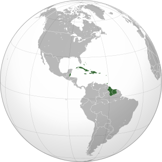
The British Virgin Islands (BVI) are one of three political divisions of the Virgin Islands archipelago located in the Lesser Antilles, between the Caribbean Sea and the North Atlantic Ocean. The BVI are the easternmost part of the island chain. The land area totals and comprises 16 inhabited and more than 20 uninhabited islands. The islands of Tortola, Anegada, Virgin Gorda and Jost van Dyke are the largest. Maritime claims include 12 nmi territorial sea and a 200 nmi exclusive fishing zone. In terms of land use, it is 20% arable land, 6.67% permanent crops and 73.33% other as of a 2005 figure. It has strong ties to nearby U.S. Virgin Islands and Puerto Rico.

The Virgin Islands are an archipelago in the Caribbean Sea. They are geologically and biogeographically the easternmost part of the Greater Antilles, the northern islands belonging to the Puerto Rico Trench and St. Croix being a displaced part of the same geologic structure. Politically, the British Virgin Islands have been governed as the western island group of the Leeward Islands, which are the northern part of the Lesser Antilles, and form the border between the Caribbean Sea and the Atlantic Ocean. The archipelago is separated from the true Lesser Antilles by the Anegada Passage and from the main island of Puerto Rico by the Virgin Passage.

The Lesser Antilles are a group of islands in the Caribbean Sea. Most of them are part of a long, partially volcanic island arc between the Greater Antilles to the north-west and the continent of South America. The islands of the Lesser Antilles form the eastern boundary of the Caribbean Sea where it meets the Atlantic Ocean. Together, the Lesser Antilles and the Greater Antilles make up the Antilles. The Lesser and Greater Antilles, together with the Lucayan Archipelago, are collectively known as the West Indies.

The Antilles is an archipelago bordered by the Caribbean Sea to the south and west, the Gulf of Mexico to the northwest, and the Atlantic Ocean to the north and east.
The Leeward Islands are a group of islands situated where the northeastern Caribbean Sea meets the western Atlantic Ocean. Starting with the Virgin Islands east of Puerto Rico, they extend southeast to Guadeloupe and its dependencies. In English, the term Leeward Islands refers to the northern islands of the Lesser Antilles chain. The more southerly part of this chain, starting with Dominica, is called the Windward Islands. Dominica was originally considered a part of the Leeward Islands, but was transferred from the British Leeward Islands to the British Windward Islands in 1940.
The Windward Islands, also known as the Islands of Barlovento, are the southern, generally larger islands of the Lesser Antilles. Part of the West Indies, they lie south of the Leeward Islands, approximately between latitudes 10° and 16° N and longitudes 60° and 62° W.

Basanite is an igneous, volcanic (extrusive) rock with aphanitic to porphyritic texture. It is composed mostly of feldspathoids, pyroxenes, olivine, and plagioclase and forms from magma low in silica and enriched in alkali metal oxides that solidifies rapidly close to the Earth's surface.

The Greater Antilles is a grouping of the larger islands in the Caribbean Sea, including Cuba, Hispaniola, Puerto Rico, Jamaica, and the Cayman Islands. Six island states share the region of the Greater Antilles, with Haiti and the Dominican Republic sharing the island of Hispaniola. Together with the Lesser Antilles, they make up the Antilles.

The Caribbean Plate is a mostly oceanic tectonic plate underlying Central America and the Caribbean Sea off the north coast of South America.

Accretion, in geology, is a process by which material is added to a tectonic plate at a subduction zone, frequently on the edge of existing continental landmasses. The added material may be sediment, volcanic arcs, seamounts, oceanic crust or other igneous features.

The West Indies are a subregion of North America, surrounded by the North Atlantic Ocean and the Caribbean Sea that includes 13 independent island countries and 18 dependencies and other territories in three major archipelagos: the Greater Antilles, the Lesser Antilles, and the Lucayan Archipelago.

The Leeward Antilles are a chain of islands in the Caribbean – specifically, the southerly islands of the Lesser Antilles along the southeastern fringe of the Caribbean Sea, just north of the Venezuelan coast of the South American mainland. The Leeward Antilles, while among the Lesser Antilles, are not to be confused with the Leeward Islands to the northeast.

The green-throated carib is a species of hummingbird in the genus Eulampis, which contains one other species. It has two subspecies, holosericeus and chlorolaemus, the former occurring in Puerto Rico and the latter in Grenada.
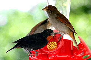
The lesser Antillean bullfinch is a species of bird in the family Thraupidae. It is found in Saint Barth, Saint Martin, Anguilla, Antigua and Barbuda, Dominica, Grenada, Guadeloupe, Martinique, Montserrat, Netherlands Antilles, Saint Kitts and Nevis, Saint Lucia, Saint Vincent and the Grenadines, the British Virgin Islands, and the U.S. Virgin Islands.
The Caribbean bioregion is a biogeographic region that includes the islands of the Caribbean Sea and nearby Atlantic islands, which share a fauna, flora and mycobiota distinct from surrounding bioregions.

The following outline is provided as an overview of and topical guide to the British Virgin Islands:
The Caribbean is a region of the Americas that comprises the Caribbean Sea, its surrounding coasts, and its islands. The region lies southeast of the Gulf of Mexico and of the North American mainland, east of Central America, and north of South America.
Peter Edward Baker (1937–2008) was a notable British volcanologist, professor emeritus of Igneous Petrology in the School of Earth Sciences, University of Leeds.
The geology of Saint Lucia includes exposed Miocene rocks—the most northerly in the Volcanic Caribbees section of the Lesser Antilles volcanic island arc. These rocks include calc-alkalkine and arc tholeiite igneous rocks. The oldest formed up to 18 million years ago in the north.
References
- ↑ "The Geology of the British Virgin Islands | Geological Magazine | Cambridge Core". cambridge.org. Retrieved 2018-11-09.