Related Research Articles

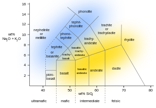
Tuff is a type of rock made of volcanic ash ejected from a vent during a volcanic eruption. Following ejection and deposition, the ash is lithified into a solid rock. Rock that contains greater than 75% ash is considered tuff, while rock containing 25% to 75% ash is described as tuffaceous. A pyroclastic rock containing 25–75% volcanic bombs and/or volcanic blocks is called tuff breccia. Tuff composed of sandy volcanic material can be referred to as volcanic sandstone.
Extrusive rock refers to the mode of igneous volcanic rock formation in which hot magma from inside the Earth flows out (extrudes) onto the surface as lava or explodes violently into the atmosphere to fall back as pyroclastics or tuff. In contrast, intrusive rock refers to rocks formed by magma which cools below the surface.

Lapilli is a size classification of tephra, which is material that falls out of the air during a volcanic eruption or during some meteorite impacts. Lapilli is Latin for "little stones".

Goat Rocks is an extinct stratovolcano in the Cascade Range, located between Mount Rainier and Mount Adams in southern Washington, in the United States. Part of the Cascade Volcanoes, it was formed by the subduction of the Juan de Fuca Plate under the western edge of the North American Plate. The volcano was active from 3.2 million years ago until eruptions ceased between 1 and 0.5 million years ago. Throughout its complex eruptive history, volcanism shifted from silicic explosive eruptions to voluminous, mafic activity.

The Borrowdale Volcanic Group is a group of igneous rock formations named after the Borrowdale area of the Lake District, in England. They are Caradocian in age. It is thought that they represent the remains of a volcanic island arc, approximately similar to the island arcs of the west Pacific today. This developed as oceanic crust to the (present) north-west and was forced by crustal movement under a continental land-mass to the present south-east. Such forcing under, as two plates meet, is termed subduction. This land-mass has been named Avalonia by geologists. It is now incorporated into England and Wales and a sliver of North America.
Birker Fell, also known as Birker Moor, is an upland wilderness area in the western portion of the Lake District National Park, in Cumbria, England. Rather than being formed of one single high peak, the fell is a broad, undulating area, approximately 6 km square, with numerous crags and prominences scattered across its area. The highest point of the fell is at Green Crag. The fell is bordered by the Duddon Valley to the south-east, Ulpha Fell to the south-west, Harter Fell to the north-east, and Eskdale to the north-west.

Watson's Dodd is a fell in the English Lake District, a minor rise on the main ridge of the Helvellyn range in the Eastern Fells, but a prominent shoulder on the west side of that range.
The Mount Pleasant Caldera is a large eroded Late Devonian volcanic caldera complex, located in the northern Appalachian Mountains of southwestern New Brunswick, Canada. It is one of few noticeable pre-Cenozoic calderas, and its formation is associated to a period of crustal thinning that followed the Acadian orogeny in the northern Appalachian Mountains. It sits relatively near to the coastline.

The Boot Heel volcanic field is located in the Bootheel region of southwest New Mexico, adjacent areas of southeastern Arizona, and northwest Mexico. The field covers an area of more than 24,000 km2. The field includes nine volcanic calderas ranging in age from 26.9 to 35.3 Ma. Extrusive products include rhyolitic ignimbrites along with basalt, andesite, and rhyolite lava flows. The major ash flow tuff sheets produced, range in volume from 35 to 650 km3.
The Western Cascades or Old Cascades are a sub-province of the Cascade Range in the U.S. state of Oregon, between the Willamette Valley and the High Cascades. The Western Cascades contain many extinct shield volcanoes, cinder cones and lava flows, and the region is highly eroded and heavily forested. Deposits of the same age as the Western Cascades are also found in southwest Washington state.
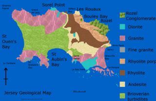
The geology of Jersey is characterised by the Late Proterozoic Brioverian volcanics, the Cadomian Orogeny, and only small signs of later deposits from the Cambrian and Quaternary periods. The kind of rocks go from conglomerate to shale, volcanic, intrusive and plutonic igneous rocks of many compositions, and metamorphic rocks as well, thus including most major types.

The Canadian Cascade Arc, also called the Canadian Cascades, is the Canadian segment of the North American Cascade Volcanic Arc. Located entirely within the Canadian province of British Columbia, it extends from the Cascade Mountains in the south to the Coast Mountains in the north. Specifically, the southern end of the Canadian Cascades begin at the Canada–United States border. However, the specific boundaries of the northern end are not precisely known and the geology in this part of the volcanic arc is poorly understood. It is widely accepted by geologists that the Canadian Cascade Arc extends through the Pacific Ranges of the Coast Mountains. However, others have expressed concern that the volcanic arc possibly extends further north into the Kitimat Ranges, another subdivision of the Coast Mountains, and even as far north as Haida Gwaii.
The San Juan volcanic field is part of the San Juan Mountains in southwestern Colorado. It consists mainly of volcanic rocks that form the largest remnant of a major composite volcanic field that covered most of the southern Rocky Mountains in the Middle Tertiary geologic time. There are approximately fifteen calderas known in the San Juan Volcanic Fields; however, it is possible that there are two or even three more in the region.
Calabozos is a Holocene caldera in central Chile's Maule Region. Part of the Chilean Andes' volcanic segment, it is considered a member of the Southern Volcanic Zone (SVZ), one of the three distinct volcanic belts of South America. This most active section of the Andes runs along central Chile's western edge, and includes more than 70 of Chile's stratovolcanoes and volcanic fields. Calabozos lies in an extremely remote area of poorly glaciated mountains.
Crevasse Crag is a jagged steep-sided prominence on the summit of a glaciated mountain ridge in the Lillooet Ranges of southwestern British Columbia, Canada. It is located about 49 km (30 mi) southeast of the village of Pemberton. Situated on the boundary between New Westminster Land District and Kamloops Division Yale Land District, the peak has a maximum elevation of 2,496 m (8,189 ft) and a topographic prominence of 66 m (217 ft).
The geology of the Northern Mariana Islands began to form with undersea volcanic eruptions in the Eocene. Islands such as Saipan show a variety of rock types including volcanic rocks, breccia, tuff, conglomerate, sandstone, clay and extensive limestones.

The geology of Uzbekistan consists of two microcontinents and the remnants of oceanic crust, which fused together into a tectonically complex but resource rich land mass during the Paleozoic, before becoming draped in thick, primarily marine sedimentary units.
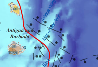
The geology of Antigua and Barbuda is part of the Lesser Antilles volcanic island arc. Both islands are the above water limestone "caps" of now inactive volcanoes. The two islands are the surface features of the undersea Barbuda Bank and have karst limestone landscapes. Barbuda is primarily flat and formed from coral reefs. The Middle Miocene Highlands Formation has limestones which are the oldest rocks on the island, rising 120 feet above sea level. The Beazer Formation and the Codrington Formation are both from the Pleistocene and include reef and lagoon related rocks.
The geology of the Collectivity of Saint Martin consists of andesite tuff and tuff breccia from the middle and late Eocene, intruded by hypabyssal basalt, quartz diorite and younger andesite. Volcanic activity led to metamorphism of many rocks and the tilting and folding of the tuff series. Limestone and marl was later unconformably deposited atop the eroded volcanic rocks as volcanic activity shifted elsewhere. Large boulder ridges and solitary boulders on high cliffs suggest tectonic-related tsunamis.
The geology of Saint Barthélemy consists of andesite tuff and tuff breccia from the middle and late Eocene, intruded by hypabyssal basalt, quartz diorite and younger andesite. Volcanic activity on neighboring Saint Martin led to metamorphism of many rocks and the tilting and folding of the tuff series. Limestone and marl was later unconformably deposited atop the eroded volcanic rocks as volcanic activity shifted elsewhere.
References
- ↑ "Geology of St. Bartholomew, St. Martin, and Anguilla, Lesser Antilles | GSA Bulletin". GeoScienceWorld. Retrieved 2018-11-09.