Related Research Articles

Canada has a vast geography that occupies much of the continent of North America, sharing a land border with the contiguous United States to the south and the U.S. state of Alaska to the northwest. Canada stretches from the Atlantic Ocean in the east to the Pacific Ocean in the west; to the north lies the Arctic Ocean. Greenland is to the northeast with a shared border on Hans Island. To the southeast Canada shares a maritime boundary with France's overseas collectivity of Saint Pierre and Miquelon, the last vestige of New France. By total area, Canada is the second-largest country in the world, after Russia. By land area alone, however, Canada ranks fourth, the difference being due to it having the world's largest proportion of fresh water lakes. Of Canada's thirteen provinces and territories, only two are landlocked while the other eleven all directly border one of three oceans.

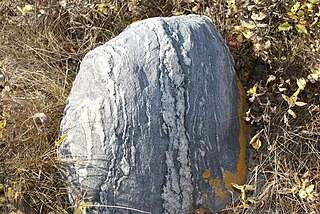
The Canadian Shield, also called the Laurentian Shield or the Laurentian Plateau, is a geologic shield, a large area of exposed Precambrian igneous and high-grade metamorphic rocks. It forms the North American Craton, the ancient geologic core of the North American continent. Glaciation has left the area with only a thin layer of soil, through which exposures of igneous bedrock resulting from its long volcanic history are frequently visible. As a deep, common, joined bedrock region in eastern and central Canada, the shield stretches north from the Great Lakes to the Arctic Ocean, covering over half of Canada and most of Greenland; it also extends south into the northern reaches of the United States.

An impact crater is a circular depression in the surface of a solid astronomical object formed by the hypervelocity impact of a smaller object. In contrast to volcanic craters, which result from explosion or internal collapse, impact craters typically have raised rims and floors that are lower in elevation than the surrounding terrain. Impact craters range in size from microscopic craters seen on lunar rocks returned by the Apollo Program to simple bowl-shaped depressions and vast, complex, multi-ringed impact basins. Meteor Crater is a well-known example of a small impact crater on Earth.

The South Pole–Aitken basin is an immense impact crater on the far side of the Moon. At roughly 2,500 km (1,600 mi) in diameter and between 6.2 and 8.2 km (3.9–5.1 mi) deep, it is one of the largest known impact craters in the Solar System. It is the largest, oldest, and deepest basin recognized on the Moon. It is estimated that it was formed 4.2 to 4.3 billion years ago, during the Pre-Nectarian epoch. It was named for two features on opposite sides of the basin: the lunar South Pole at one end and the crater Aitken on the northern end. The outer rim of this basin can be seen from Earth as a huge mountain chain located on the Moon's southern limb, sometimes informally called "Leibnitz mountains".
The Sudbury Basin, also known as Sudbury Structure or the Sudbury Nickel Irruptive, is a major geological structure in Ontario, Canada. It is the third-largest known impact crater or astrobleme on Earth, as well as one of the oldest. The crater was formed 1.849 billion years ago in the Paleoproterozoic era.
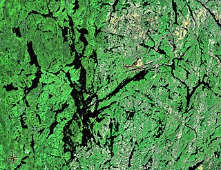
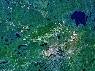
Lake Temagami, formerly spelled as Lake Timagami, is a lake in Nipissing District in northeastern Ontario, Canada, situated approximately 80 km north of North Bay. The lake's name comes from dimii-agamiing "tih-MEE-uh-guh-MEENG", which means "it is deep water by the shore" in the Ojibwa language.

The geology of the Moon is quite different from that of Earth. The Moon lacks a true atmosphere, and the absence of free oxygen and water eliminates erosion due to weather. Instead, the surface is eroded much more slowly through the bombardment of the lunar surface by micrometeorites. It does not have any known form of plate tectonics, it has a lower gravity, and because of its small size, it cooled faster. In addition to impacts, the geomorphology of the lunar surface has been shaped by volcanism, which is now thought to have ended less than 50 million years ago. The Moon is a differentiated body, with a crust, mantle, and core.
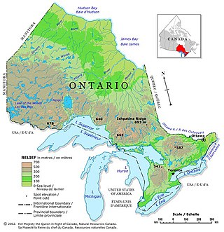
Ontario is located in East/Central Canada. It is Canada's second largest province by land area. Its physical features vary greatly from the Mixedwood Plains in the southeast to the boreal forests and tundra in the north. Ontario borders Manitoba to the west, Hudson Bay and James Bay to the north, Quebec to the east, and the Great Lakes and the United States to the south. The province is named for Great Lake Ontario, an adaptation of the Iroquois word Onitariio, meaning "beautiful lake", or Kanadario, variously translated as "beautiful water". There are approximately 250,000 lakes and over 100,000 kilometres (62,000 mi) of rivers in the province.

Temagami, formerly spelled Timagami, is a municipality in northeastern Ontario, Canada, in the Nipissing District with Lake Temagami at its heart.

Creighton Mine is an underground nickel, copper, and platinum-group elements (PGE) mine. It is presently owned and operated by Vale Limited in the city of Greater Sudbury, Ontario, Canada. Open pit mining began in 1901, and underground mining began in 1906. The mine is situated in the Sudbury Igneous Complex (SIC) in its South Range geologic unit. The mine is the source of many excavation-related seismic events, such as earthquakes and rock burst events. It is home to SNOLAB, and is currently the deepest nickel mine in Canada. Expansion projects to deepen the Creighton Mine are currently underway.

The Temagami Greenstone Belt (TGB) is a small 2.7 billion year old greenstone belt in the Temagami region of Northeastern Ontario, Canada. It represents a feature of the Superior craton, an ancient and stable part of the Earth's lithosphere that forms the core of the North American continent and Canadian Shield. The belt is composed of metamorphosed volcanic rocks that range in composition from basalt to rhyolite. These form the east-northeast trend of the belt and are overlain by metamorphosed sedimentary rocks. They were created during several volcanic episodes involving a variety of eruptive styles ranging from passive lava eruptions to viscous explosive eruptions.

The Temagami Magnetic Anomaly, also called the Temagami Anomaly or the Wanapitei Anomaly, is a magnetic anomaly resulting from a large buried geologic structure in the Canadian Shield near Temagami, Ontario, Canada. It stretches from Lake Wanapitei in the west to Bear Island in Lake Temagami.
The geology of Saskatchewan can be divided into two main geological regions, the Precambrian Canadian Shield and the Phanerozoic Western Canadian Sedimentary Basin. Within the Precambrian shield exists the Athabasca sedimentary basin. Meteorite impacts have altered the natural geological formation processes. The prairies were most recently affected by glacial events in the Quaternary period.
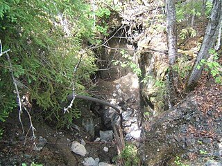
Beanland Mine, also known as Clenor Mine, is an abandoned surface and underground mine in Northeastern Ontario, Canada. It is located about 1 km (0.62 mi) west of Arsenic Lake and 4 km (2.5 mi) northwest of the town of Temagami in central Strathy Township. It is named after Sydney Beanland, who first claimed the mine site in the 1920s and was a director for the mine from 1937 to 1938.

Big Dan Mine is an abandoned underground mine in Northeastern Ontario, Canada. It is located about 1 km (0.62 mi) southwest of Net Lake and just west of the Ontario Northland Railway in east-central Strathy Township. It is named after Dan O'Connor, who first claimed the site in the 1890s.
Mars may contain ores that would be very useful to potential colonists. The abundance of volcanic features together with widespread cratering are strong evidence for a variety of ores. While nothing may be found on Mars that would justify the high cost of transport to Earth, the more ores that future colonists can obtain from Mars, the easier it would be to build colonies there.

The Bangui magnetic anomaly is a local variation in the Earth's magnetic field centered at Bangui, the capital of the Central African Republic. The magnetic anomaly is roughly elliptical, about 700 km × 1,000 km, and covers most of the country, making it one of the "largest and most intense crustal magnetic anomalies on the African continent". The anomaly was discovered in the late 1950s, explored in the 1970s, and named in 1982. Its origin remains unclear.

The geology of Ontario is the study of rock formations in the most populated province in Canada- it is home to some of the oldest rock on Earth. The geology in Ontario consists of ancient Precambrian igneous and metamorphic rock which sits under younger, sedimentary rocks and soils.

The geology of Namibia encompasses rocks of Paleoproterozoic, Mesoproterozoic and Neoproterozoic and Paleozoic to Cenozoic age. About 46% of the countryʼs surface are bedrock exposure, while the remainder is covered by the young overburden sediments of the Kalahari and Namib deserts.
References
- 1 2 Wallace, Stewart W. (1948). Geology Of Canada. The Encyclopedia of Canada. Vol. III. Toronto: University Associates of Canada. pp. 23–26. Archived from the original on 4 July 2010. Retrieved 1 June 2011– via faculty.marianopolis.edu.
- ↑ "Digging for Diamonds 24/7 Under Frozen Snap Lake". Wired.com. Wired. Retrieved 1 June 2011.
- ↑ "3-D Magnetic Imaging using Conjugate Gradients: Temagami anomaly". Archived from the original on 11 July 2009. Retrieved 13 March 2008.